Property valuation of SW 20th Street, Akron, OH (tax assessments)
Other nearby streets: Harpster Avenue  SW 19th Street (1)
SW 19th Street (2)
SW 20th Street
SW 21st Street
SW 19th Street (1)
SW 19th Street (2)
SW 20th Street
SW 21st Street
SW 19th Street (1)
SW 19th Street (2)
SW 20th Street
SW 21st Street
Listed properties vs overall distribution of properties in Akron, OH:
Advertisements
SW 20th Street
Akron, OH 44314
Find on map >>
Owner: J E PARKER
Land value: $1,070
Total value for property: $1,070
Class: Residential
Land use: Residential, Vacant Land, Lot
Land area: 701 square feet
Land frontage: 39 feet
Land depth: 18 feet
Land depth table: 150 feet
Land depth factor: 0.32
Square footage: 702 square feet
Reason: Reappraisal
Assessments for tax year: 2009
SW 20th Street
Akron, OH 44314
Find on map >>
Owner: GENEVIEVE C KARDER TRUSTEE
Land value: $260
Total value for property: $260
Class: Residential
Land use: Residential, Vacant Land, Lot
Land area: 169 square feet
Land frontage: 42 feet
Land depth: 4 feet
Land depth table: 150 feet
Land depth factor: 0.10
Square footage: 168 square feet
Reason: Reappraisal
Assessments for tax year: 2009
Sales:
-
Sale date: 02/04/2008
Old owner name: MIKE KARDER
New owner name: MIKE KARDER TRUSTEE
-
Sale date: 04/29/2008
Old owner name: MIKE KARDER TRUSTEE
New owner name: GENEVIEVE C KARDER TRUSTEE
SW 20th Street
Akron, OH 44314
Find on map >>
Owner: MICHAEL B GREEN
Land value: $1,960
Total value for property: $1,960
Class: Residential
Land use: Residential, Vacant Land, Lot
Land area: 940 square feet
Land frontage: 41 feet
Land depth: 23 feet
Land depth table: 150 feet
Land depth factor: 0.38
Square footage: 943 square feet
Reason: Reappraisal
Assessments for tax year: 2009
SW 20th Street
Akron, OH 44314
Find on map >>
Owner: HENRY S MARTIN
Land value: $790
Total value for property: $790
Class: Residential
Land use: Residential, Vacant Land, Lot
Land area: 108 square feet
Land frontage: 9 feet
Land depth: 12 feet
Land depth table: 150 feet
Land depth factor: 0.25
Square footage: 108 square feet
Reason: Reappraisal
Assessments for tax year: 2009
SW 20th Street
Akron, OH 44314
Find on map >>
Owner: PROGRESSIVE CHURCH OF GOD IN TRUE HOLINESS INC
Land value: $8,110
Total value for property: $8,110
Class: Exempt
Land use: Churches Etc Public Worship Prive
Land area: 2,949 square feet
Land depth factor: 1.00
Square footage: 2,950 square feet
Reason: Reappraisal
Assessments for tax year: 2009
Sale date: 11/21/1990
Price: $1,500
Old owner name: LORRAINE MELTON
New owner name: PROGRESSIVE CHURCH OF GOD
Validity: Valid
SW 20th Street
Akron, OH 44314
Find on map >>
Owner: VON GUNTEN PROPERTIES LLC
Land value: $14,980
Total value for property: $14,980
Class: Residential
Land use: Residential, Vacant Land, Lot
Land area: 4,748 square feet
Land frontage: 42 feet
Land depth: 113 feet
Land depth table: 150 feet
Land depth factor: 0.86
Square footage: 4,746 square feet
Reason: Miscellaneous reasons
Assessments for tax year: 2009
Sales:
-
Sale date: 09/14/1999
Price: $38,000
Old owner name: IMC MORTGAGE COMPANY
New owner name: TONY J COZZOLI III
Validity: Valid
-
Sale date: 09/14/1999
Price: $33,000
Old owner name: BARBARA KING
New owner name: IMC MORTGAGE COMPANY
Validity: Foreclosure/Sheriff Sale
-
Sale date: 04/21/2006
Price: $8,850
Old owner name: TONY J COZZOLI III
New owner name: VON GUNTEN PROPERTIES LLC
Validity: Mortgage/lender
SW 20th Street
Akron, OH 44314
Find on map >>
Owner: PAUL KANTOROWSKI
Land value: $490
Total value for property: $490
Class: Residential
Land use: Residential, Vacant Land, Lot
Land area: 1,350 square feet
Land frontage: 45 feet
Land depth: 30 feet
Land depth table: 150 feet
Land depth factor: 0.45
Square footage: 1,350 square feet
Reason: Reappraisal
Assessments for tax year: 2009
Sale date: 07/21/2000
Price: $39,500
Old owner name: LEO L LANEY
New owner name: PAUL KANTOROWSKI
Validity: Vacant
SW 20th Street
Akron, OH 44314
Find on map >>
Owner: J E PARKER
Land value: $1,650
Total value for property: $1,650
Class: Residential
Land use: Residential, Vacant Land, Lot
Land area: 736 square feet
Land frontage: 41 feet
Land depth: 18 feet
Land depth table: 150 feet
Land depth factor: 0.32
Square footage: 738 square feet
Reason: Reappraisal
Assessments for tax year: 2009
SW 20th Street
Akron, OH 44314
Find on map >>
Owner: MICHAEL FRANCES PARTNERSHIP
Land value: $1,250
Total value for property: $1,250
Class: Residential
Land use: Residential, Vacant Land, Lot
Land area: 461 square feet
Land frontage: 42 feet
Land depth: 11 feet
Land depth table: 150 feet
Land depth factor: 0.24
Square footage: 462 square feet
Reason: Reappraisal
Assessments for tax year: 2009
SW 20th Street
Akron, OH 44314
Find on map >>
Owner: PAUL KANTOROWSKI
Land value: $690
Total value for property: $690
Class: Residential
Land use: Residential, Vacant Land, Lot
Land area: 2,787 square feet
Land frontage: 45 feet
Land depth: 62 feet
Land depth table: 150 feet
Land depth factor: 0.64
Square footage: 2,790 square feet
Reason: Reappraisal
Assessments for tax year: 2009
Sale date: 07/21/2000
Price: $39,500
Old owner name: LEO L LANEY
New owner name: PAUL KANTOROWSKI
Validity: Vacant
Other nearby streets: Harpster Avenue
SW 19th Street (1)
SW 19th Street (2)
SW 20th Street
SW 21st Street
SW 19th Street (1)
SW 19th Street (2)
SW 20th Street
SW 21st Street

Recent posts about Akron, Ohio on our local forum with over 2,400,000 registered users. Akron is mentioned 2,692 times on our forum:
 | possible move to Akron Ohio (5 replies) |
| Safe/good parts of Akron? (4 replies) |
| Tell me about Akron area (17 replies) |
| Relationship between Akron and Cleveland (14 replies) |
| Akron vs Dayton? (4 replies) |
| Safe & affordable places in Akron for young woman (5 replies) |
Settings
X

Recently Added Photos

Akron, OH
Akron, OH

Akron, OH

Akron, OH
Akron, OH
Akron, OH

Akron, OH

Akron, OH

Akron, OH

Akron, OH

Akron, OH

Akron, OH
Request disassociating your name from street-level assessment address

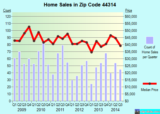
Recent home sales, price trends, and home value evaluator powered by Onboard Informatics
© 2024 Onboard Informatics. Information is deemed reliable but not guaranteed.
© 2024 Onboard Informatics. Information is deemed reliable but not guaranteed.
Some parts © 2024 Advameg, Inc.
Compilation, repackaging, or reproduction prohibited. Users are forewarned that it is incumbent upon them to verify information with the responsible state agency. Advameg, Inc. does not guarantee the data presented is up-to-date nor does it assume responsibility for updating it. Therefore any names, owners or addresses may have changed. Use of any information published here to contact the persons might be prohibited by the law.