Property valuation of Mamie Street, Barberton, OH (tax assessments)
Other nearby streets: Mamie Street (1)  Mamie Street (2)
Tapper Road
Watkins Road (1)
Watkins Road (2)
Mamie Street (2)
Tapper Road
Watkins Road (1)
Watkins Road (2)
Mamie Street (2)
Tapper Road
Watkins Road (1)
Watkins Road (2)
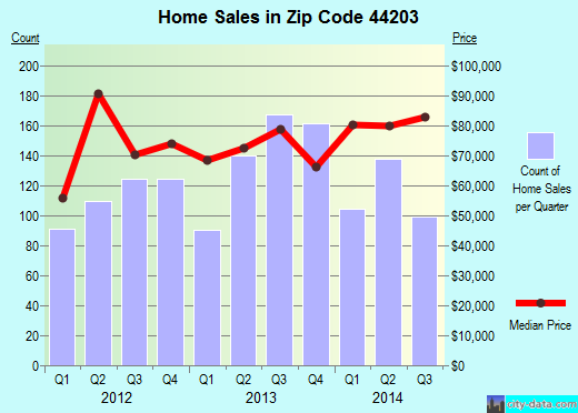
Listed properties vs overall distribution of properties in Barberton, OH:
Advertisements
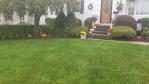
Mamie Street
Barberton, OH 44203
Find on map >>
Owner: JOHN C CROFT JR
Land value: $5,580
Total value for property: $5,580
Class: Residential
Land use: Residential, Vacant Land, Lot
Land area: 42,501 square feet
Land frontage: 100 feet
Land depth: 425 feet
Land depth table: 150 feet
Land depth factor: 1.24
Square footage: 42,500 square feet
Reason: Reappraisal
Assessments for tax year: 2009
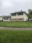
Mamie Street
Barberton, OH 44203
Find on map >>
Owner: KIM FRANCHI
Land value: $830
Total value for property: $830
Class: Residential
Land use: Residential, Vacant Land, Lot
Land area: 4,791 square feet
Land depth factor: 1.00
Square footage: 4,792 square feet
Reason: Reappraisal
Assessments for tax year: 2009
Sales:
-
Sale date: 02/02/2000
Price: $131,500
Old owner name: CHERYL L WARNER & STEVE E WARNER
New owner name: JOHN H KREPS JR & TAMI L KREPS
Validity: Multiple Parcel Sale
-
Sale date: 08/15/2000
Price: $132,000
Old owner name: JOHN H KREPS JR & TAMI L KREPS
New owner name: KIM FRANCHI
Validity: Valid
Mamie Street
Barberton, OH 44203
Find on map >>
Owner: JOHN C CROFT JR
Land value: $3,270
Total value for property: $3,270
Class: Residential
Land use: Residential, Vacant Land, Lot
Land area: 33,001 square feet
Land frontage: 100 feet
Land depth: 330 feet
Land depth table: 150 feet
Land depth factor: 1.21
Square footage: 33,001 square feet
Reason: Reappraisal
Assessments for tax year: 2009
Mamie Street
Barberton, OH 44203
Find on map >>
Owner: JOHN C CROFT JR
Land value: $5,580
Total value for property: $5,580
Class: Residential
Land use: Residential, Vacant Land, Lot
Land area: 42,000 square feet
Land frontage: 100 feet
Land depth: 420 feet
Land depth table: 150 feet
Land depth factor: 1.24
Square footage: 42,000 square feet
Reason: Reappraisal
Assessments for tax year: 2009
Mamie Street
Barberton, OH 44203
Find on map >>
Owner: JOHN C CROFT JR
Land value: $3,200
Total value for property: $3,200
Class: Residential
Land use: Residential, Vacant Land, Lot
Land area: 36,734 square feet
Land frontage: 93 feet
Land depth: 395 feet
Land depth table: 150 feet
Land depth factor: 1.23
Square footage: 36,734 square feet
Reason: Reappraisal
Assessments for tax year: 2009
Mamie Street
Barberton, OH 44203
Find on map >>
Owner: JOHN C CROFT JR
Land value: $5,700
Total value for property: $5,700
Class: Residential
Land use: Residential, Vacant Land, Lot
Land area: 33,105 square feet
Land depth factor: 1.00
Square footage: 33,106 square feet
Reason: Reappraisal
Assessments for tax year: 2009
Mamie Street
Barberton, OH 44203
Find on map >>
Owner: JOHN C CROFT JR
Land value: $5,330
Total value for property: $5,330
Class: Residential
Land use: Residential, Vacant Land, Lot
Land area: 30,927 square feet
Land depth factor: 1.00
Square footage: 30,928 square feet
Reason: Reappraisal
Assessments for tax year: 2009
Mamie Street
Barberton, OH 44203
Find on map >>
Owner: JOHN C CROFT JR
Land value: $4,350
Total value for property: $4,350
Class: Residential
Land use: Residential, Vacant Land, Lot
Land area: 25,264 square feet
Land depth factor: 1.00
Square footage: 25,265 square feet
Reason: Reappraisal
Assessments for tax year: 2009
Mamie Street
Barberton, OH 44203
Find on map >>
Owner: JOHN C CROFT JR
Land value: $4,540
Total value for property: $4,540
Class: Residential
Land use: Residential, Vacant Land, Lot
Land area: 48,787 square feet
Land depth factor: 1.00
Square footage: 48,787 square feet
Reason: Reappraisal
Assessments for tax year: 2009
Mamie Street
Barberton, OH 44203
Find on map >>
Owner: JOHN C CROFT JR
Land value: $4,430
Total value for property: $4,430
Class: Residential
Land use: Residential, Vacant Land, Lot
Land area: 25,700 square feet
Land depth factor: 1.00
Square footage: 25,700 square feet
Reason: Reappraisal
Assessments for tax year: 2009
Other nearby streets: Mamie Street (1)
Mamie Street (2)
Tapper Road
Watkins Road (1)
Watkins Road (2)
Mamie Street (2)
Tapper Road
Watkins Road (1)
Watkins Road (2)

Recent posts about Barberton, Ohio on our local forum with over 2,400,000 registered users. Barberton is mentioned 150 times on our forum:
 | What are your thoughts on the Norton/Barberton area? (1 reply) |
| Lakemore or Barberton (8 replies) |
| Looking for friends of Doug Brown (0 replies) |
| Barberton school district...and open enrollment (0 replies) |
| Looking for a good local cheese/dairy farm. (3 replies) |
| No more Barberton Gardens? (0 replies) |
Settings
X

Recently Added Photos

Barberton, OH

Barberton, OH
Middletown, OH
Middletown, OH
Lisbon, OH
Parma, OH
Cuyahoga Falls, OH

Rocky River, OH
Mayfield Heights, OH

Rocky River, OH

Garfield Heights, OH

Harrison, OH
Request disassociating your name from street-level assessment address

Recent home sales, price trends, and home value evaluator powered by Onboard Informatics
© 2024 Onboard Informatics. Information is deemed reliable but not guaranteed.
© 2024 Onboard Informatics. Information is deemed reliable but not guaranteed.
Some parts © 2024 Advameg, Inc.
Compilation, repackaging, or reproduction prohibited. Users are forewarned that it is incumbent upon them to verify information with the responsible state agency. Advameg, Inc. does not guarantee the data presented is up-to-date nor does it assume responsibility for updating it. Therefore any names, owners or addresses may have changed. Use of any information published here to contact the persons might be prohibited by the law.