Property valuation of Johnston Street, Akron, OH (tax assessments)
Other nearby streets: John Street  Johnston Street (1)
Johnston Street (2)
Johnston Street (3)
Johnston Street (4)
Johnston Street (1)
Johnston Street (2)
Johnston Street (3)
Johnston Street (4)
Johnston Street (1)
Johnston Street (2)
Johnston Street (3)
Johnston Street (4)
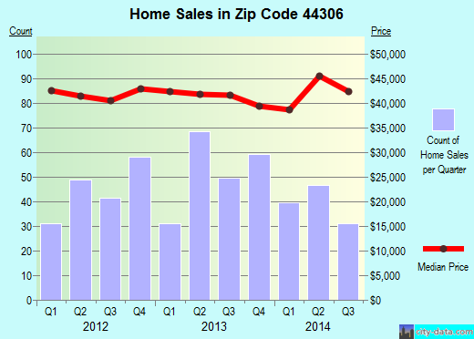
Listed properties vs overall distribution of properties in Akron, OH:
Advertisements
Johnston Street
Akron, OH
Find on map >>
Owner: MARY A HARRIS
Land value: $2,990
Total value for property: $2,990
Class: Residential
Land use: Residential, Vacant Land, Lot
Land area: 4,090 square feet
Land frontage: 31 feet
Land depth: 132 feet
Land depth table: 150 feet
Land depth factor: 0.94
Square footage: 4,092 square feet
Reason: Reappraisal
Assessments for tax year: 2009
Sales:
-
Sale date: 11/09/1995
Old owner name: GEORGE JOSEPH TRUSTEE
New owner name: BLANCHE M JOSEPH ETAL
-
Sale date: 11/30/1995
Price: $300
Old owner name: BLANCHE M JOSEPH ETAL
New owner name: PAUL M HARRIS
Validity: Valid
Source: Buyer
-
Sale date: 08/03/1998
Old owner name: PAUL M HARRIS
New owner name: MARY A HARRIS
Johnston Street
Akron, OH
Find on map >>
Owner: JOEL A HELMS
Land value: $6,750
Total value for property: $6,750
Class: Industrial
Land use: Industrial, Vacant Land
Land area: 6,534 square feet
Land depth factor: 1.00
Square footage: 6,534 square feet
Reason: Reappraisal
Assessments for tax year: 2009
Akron, OH
Find on map >>
Owner: JOEL A HELMS
Land value: $6,750
Total value for property: $6,750
Class: Industrial
Land use: Industrial, Vacant Land
Land area: 6,534 square feet
Land depth factor: 1.00
Square footage: 6,534 square feet
Reason: Reappraisal
Assessments for tax year: 2009
Johnston Street
Akron, OH
Find on map >>
Owner: CENTRAL BAPTIST CHURCH
Building value: $2,400
Land value: $13,170
Total value for property: $15,570
Class: Exempt
Land use: Churches Etc Public Worship Prive
Land area: 4,787 square feet
Land depth factor: 1.00
Square footage: 4,788 square feet
Reason: Reappraisal
Assessments for tax year: 2009
Johnston Street
Akron, OH
Find on map >>
Owner: KENNETH R KILEY
Land value: $2,590
Total value for property: $2,590
Class: Residential
Land use: Residential, Vacant Land, Lot
Land area: 1,049 square feet
Land frontage: 10 feet
Land depth: 105 feet
Land depth table: 150 feet
Land depth factor: 0.83
Square footage: 1,050 square feet
Reason: Reappraisal
Assessments for tax year: 2009
Sales:
-
Sale date: 02/26/1998
Old owner name: KENNETH R KILEY & PAMELA J KILEY
New owner name: KENNETH R KILEY & PAMELA J KILEY
-
Sale date: 02/26/1998
Price: $115,900
Old owner name: KENNETH R KILEY & PAMELA J KILEY
New owner name: KENNETH R KILEY & PAMELA J KILEY
Validity: Part Interest
-
Sale date: 11/28/2001
Price: $15,000
Old owner name: KENNETH R KILEY & PAMELA J KILEY
New owner name: KENNETH R KILEY & PAMELA J KILEY & MILLER KILEY
Validity: Vacant
-
Sale date: 08/26/2005
Price: $15,000
Old owner name: KENNETH R KILEY & PAMELA J KILEY & MILLER KILEY
New owner name: KENNETH R KILEY & PAMELA J KILEY
Validity: Part Interest
-
Sale date: 03/23/2007
Old owner name: KENNETH R KILEY & PAMELA J KILEY
New owner name: KENNETH R KILEY
-
Sale date: 05/11/2007
Old owner name: KENNETH R KILEY
New owner name: KENNETH R KILEY
Johnston Street
Akron, OH
Find on map >>
Owner: JOEL A HELMS
Land value: $8,080
Total value for property: $8,080
Class: Residential
Land use: Residential, Vacant Land, Lot
Land area: 5,536 square feet
Land frontage: 41 feet
Land depth: 135 feet
Land depth table: 150 feet
Land depth factor: 0.95
Square footage: 5,535 square feet
Reason: Reappraisal
Assessments for tax year: 2009
Johnston Street
Akron, OH
Find on map >>
Owner: KAREN L KALAVITY
Land value: $5,720
Total value for property: $5,720
Class: Commercial
Land use: Commercial Vacant Land
Land area: 3,467 square feet
Land depth factor: 1.00
Square footage: 3,468 square feet
Reason: Reappraisal
Assessments for tax year: 2009
Akron, OH
Find on map >>
Owner: KAREN L KALAVITY
Land value: $5,720
Total value for property: $5,720
Class: Commercial
Land use: Commercial Vacant Land
Land area: 3,467 square feet
Land depth factor: 1.00
Square footage: 3,468 square feet
Reason: Reappraisal
Assessments for tax year: 2009
Johnston Street
Akron, OH
Find on map >>
Owner: DONALD N PORTER
Land value: $1,250
Total value for property: $1,250
Class: Industrial
Land use: Industrial, Vacant Land
Land area: 453 square feet
Land depth factor: 1.00
Square footage: 453 square feet
Reason: Reappraisal
Assessments for tax year: 2009
Sale date: 11/28/2000
Old owner name: ETHEL M PORTER & DONALD N PORTER
New owner name: DONALD N PORTER
Johnston Street
Akron, OH
Find on map >>
Owner: DONALD N PORTER
Land value: $2,500
Total value for property: $2,500
Class: Industrial
Land use: Industrial, Vacant Land
Land area: 910 square feet
Land depth factor: 1.00
Square footage: 910 square feet
Reason: Reappraisal
Assessments for tax year: 2009
Sale date: 11/28/2000
Old owner name: ETHEL M PORTER & DONALD N PORTER
New owner name: DONALD N PORTER
Johnston Street
Akron, OH
Find on map >>
Owner: MOLLIE K LTD
Land value: $22,560
Total value for property: $22,560
Class: Commercial
Land use: Commercial Vacant Land
Land area: 8,206 square feet
Land depth factor: 1.00
Square footage: 8,205 square feet
Reason: Reappraisal
Assessments for tax year: 2009
Sales:
Akron, OH
Find on map >>
Owner: MOLLIE K LTD
Land value: $22,560
Total value for property: $22,560
Class: Commercial
Land use: Commercial Vacant Land
Land area: 8,206 square feet
Land depth factor: 1.00
Square footage: 8,205 square feet
Reason: Reappraisal
Assessments for tax year: 2009
Sales:
-
Sale date: 01/04/2001
Old owner name: OHIO CITIZENS TRUST COMPANY TRUSTEE
New owner name: FIFTH THIRD BANK TRUSTEE
-
Sale date: 03/14/2007
Old owner name: FIFTH THIRD BANK TRUSTEE
New owner name: MOLLIE K LTD
Johnston Street
Akron, OH 44306
Find on map >>
Owner: JOHN H HOWARD
Land value: $13,240
Total value for property: $13,240
Class: Residential
Land use: Residential, Vacant Land, Lot
Land area: 4,726 square feet
Land frontage: 45 feet
Land depth: 105 feet
Land depth table: 150 feet
Land depth factor: 0.83
Square footage: 4,725 square feet
Reason: Reappraisal
Assessments for tax year: 2009
Other nearby streets: John Street
Johnston Street (1)
Johnston Street (2)
Johnston Street (3)
Johnston Street (4)
Johnston Street (1)
Johnston Street (2)
Johnston Street (3)
Johnston Street (4)

Recent posts about Akron, Ohio on our local forum with over 2,400,000 registered users. Akron is mentioned 2,692 times on our forum:
 | possible move to Akron Ohio (5 replies) |
| Safe/good parts of Akron? (4 replies) |
| Tell me about Akron area (17 replies) |
| Relationship between Akron and Cleveland (14 replies) |
| Akron vs Dayton? (4 replies) |
| Safe & affordable places in Akron for young woman (5 replies) |
Settings
X

Recently Added Photos

Akron, OH
Akron, OH

Akron, OH

Akron, OH

Akron, OH
Akron, OH

Akron, OH

Akron, OH

Akron, OH

Akron, OH

Akron, OH

Akron, OH
Request disassociating your name from street-level assessment address

Recent home sales, price trends, and home value evaluator powered by Onboard Informatics
© 2024 Onboard Informatics. Information is deemed reliable but not guaranteed.
© 2024 Onboard Informatics. Information is deemed reliable but not guaranteed.
Some parts © 2024 Advameg, Inc.
Compilation, repackaging, or reproduction prohibited. Users are forewarned that it is incumbent upon them to verify information with the responsible state agency. Advameg, Inc. does not guarantee the data presented is up-to-date nor does it assume responsibility for updating it. Therefore any names, owners or addresses may have changed. Use of any information published here to contact the persons might be prohibited by the law.