Property valuation of Canton Road, Akron, OH (tax assessments)
Other nearby streets: Canton Road (1)  Canton Road (2)
Canton Road (3)
Canton Road (4)
Canton Road (5)
Canton Road (2)
Canton Road (3)
Canton Road (4)
Canton Road (5)
Canton Road (2)
Canton Road (3)
Canton Road (4)
Canton Road (5)
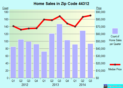
Listed properties vs overall distribution of properties in Akron, OH:
Advertisements
Canton Road
Akron, OH 44312
Find on map >>
Owner: JOHN L KLINE
Land value: $72,150
Total value for property: $72,150
Class: Commercial
Land use: Commercial Vacant Land
Land area: 43,560 square feet
Land depth factor: 1.00
Square footage: 43,560 square feet
Reason: Reappraisal
Assessments for tax year: 2009
Sales:
-
Sale date: 06/18/1996
Price: $11,750
Old owner name: WILLIAM PETROCHUK & JOHN L KLINE
New owner name: WILLIAM PETROCHUK & JOHN L KLINE
Validity: Valid
-
Sale date: 06/18/1996
Price: $11,750
Old owner name: WILLIAM PETROCHUK & JOHN L KLINE ETAL
New owner name: WILLIAM PETROCHUK & JOHN L KLINE ETAL
Validity: Valid
-
Sale date: 06/18/1996
Price: $11,750
Old owner name: WILLIAM PETROCHUK & JOHN L KLINE ETAL
New owner name: WILLIAM PETROCHUK & JOHN L KLINE ETAL
Validity: Valid
-
Sale date: 06/18/1996
Price: $35,250
Old owner name: WILLIAM PETROCHUK & JOHN L KLINE
New owner name: WILLIAM PETROCHUK & JOHN L KLINE
Validity: Valid
-
Sale date: 02/08/2006
Price: $74,000
Old owner name: WILLIAM PETROCHUK & JOHN L KLINE
New owner name: JOHN L KLINE
Validity: Vacant
Canton Road
Akron, OH 44312
Find on map >>
Owner: RODNEY D MOYERS
Land value: $1,380
Total value for property: $1,380
Class: Commercial
Land use: Commercial Vacant Land
Land area: 1,528 square feet
Land depth factor: 1.00
Square footage: 1,530 square feet
Reason: Miscellaneous reasons
Assessments for tax year: 2009
Sale date: 05/03/2007
Old owner name: RODNEY D MOYERS
New owner name: RODNEY D MOYERS
Canton Road
Akron, OH 44312
Find on map >>
Owner: KERN PROPERTIES L L C
Land value: $11,470
Total value for property: $11,470
Class: Residential
Land use: Residential, Vacant Land, Lot
Land area: 19,079 square feet
Land frontage: 60 feet
Land depth: 318 feet
Land depth table: 150 feet
Land depth factor: 1.21
Square footage: 19,079 square feet
Reason: Reappraisal
Assessments for tax year: 2009
Sale date: 04/23/1998
Price: $175,000
Old owner name: VIRGINIA V BABB
New owner name: KERN PROPERTIES L L C
Validity: Life Estate
Source: Other
Canton Road
Akron, OH 44312
Find on map >>
Owner: ECHO GETGO PARTNERS 2004
Land value: $7,350
Total value for property: $7,350
Class: Commercial
Land use: Commercial Vacant Land
Land area: 21,344 square feet
Land depth factor: 1.00
Square footage: 21,344 square feet
Reason: Reappraisal
Assessments for tax year: 2009
Sale date: 10/28/2005
Price: $140,000
Old owner name: PORTS PETROLEUM COMPANY INC
New owner name: ECHO GETGO PARTNERS 2004
Validity: Multiple Parcel Sale
Canton Road
Akron, OH 44312
Find on map >>
Owner: EISENZIMMER FREDERICK A CO TRUSTEE
Land value: $21,320
Total value for property: $21,320
Class: Residential
Land use: Residential, Vacant Land, Lot
Land area: 39,813 square feet
Land depth factor: 1.00
Square footage: 39,814 square feet
Reason: Reappraisal
Assessments for tax year: 2009
Sale date: 12/30/2004
Old owner name: FRANK B EISENZIMMER TRUSTEE
New owner name: FREDERICK A EISENZIMMER & GEORGE W EISENZIMMER
Canton Road
Akron, OH 44312
Find on map >>
Owner: PHILLIP J SAUERS
Land value: $2,420
Total value for property: $2,420
Class: Residential
Land use: Residential, Vacant Land, Lot
Land area: 11,761 square feet
Land depth factor: 1.00
Square footage: 11,761 square feet
Reason: Reappraisal
Assessments for tax year: 2009
Canton Road
Akron, OH 44312
Find on map >>
Owner: HOPKINS LAWVER FUNERAL HOME INC
Land value: $16,380
Total value for property: $16,380
Class: Commercial
Land use: Commercial Vacant Land
Land area: 5,039 square feet
Land depth factor: 1.00
Square footage: 5,040 square feet
Reason: Reappraisal
Assessments for tax year: 2009
Canton Road
Akron, OH 44312
Find on map >>
Owner: COMMUNITY BAPTIST TEMPLE
Land value: $21,450
Total value for property: $21,450
Class: Commercial
Land use: Commercial Vacant Land
Land area: 8,581 square feet
Land depth factor: 1.00
Square footage: 8,580 square feet
Reason: Miscellaneous reasons
Assessments for tax year: 2009
Sales:
-
Sale date: 09/20/2004
Price: $19,690
Old owner name: COMMUNITY BAPTIST TEMPLE
New owner name: LEDIEL PROPERTIES LLC
Validity: Investment company
-
Sale date: 03/15/2005
Old owner name: LEDIEL PROPERTIES LLC
New owner name: LEIDEL PROPERTIES LLC
-
Sale date: 04/29/2008
Price: $710,000
Old owner name: LEIDEL PROPERTIES LLC
New owner name: COMMUNITY BAPTIST TEMPLE
Validity: Church or religious organization
Canton Road
Akron, OH 44312
Find on map >>
Owner: JAMES R WHITTAKER & VICKI M POSTEN ETAL
Land value: $17,240
Total value for property: $17,240
Class: Commercial
Land use: Commercial Vacant Land
Land area: 8,620 square feet
Land depth factor: 1.00
Square footage: 8,620 square feet
Reason: Reappraisal
Assessments for tax year: 2009
Sales:
-
Sale date: 03/20/1997
Old owner name: ROSE M WHITTAKER
New owner name: JAMES R WHITTAKER ETAL
-
Sale date: 03/28/1997
Price: $108,800
Old owner name: JAMES R WHITTAKER ETAL
New owner name: JAMES R WHITTAKER & POSTEN WHITTAKER
Validity: Valid
Canton Road
Akron, OH 44312
Find on map >>
Owner: COMMUNITY BAPTIST TEMPLE
Land value: $21,880
Total value for property: $21,880
Class: Exempt
Land use: Churches Etc Public Worship Prive
Land area: 8,751 square feet
Land depth factor: 1.00
Square footage: 8,750 square feet
Reason: Reappraisal
Assessments for tax year: 2009
Sale date: 09/07/2000
Old owner name: CANTON ROAD BAPTIST CHURCH
New owner name: COMMUNITY BAPTIST TEMPLE
Other nearby streets: Canton Road (1)
Canton Road (2)
Canton Road (3)
Canton Road (4)
Canton Road (5)
Canton Road (2)
Canton Road (3)
Canton Road (4)
Canton Road (5)

Recent posts about Akron, Ohio on our local forum with over 2,400,000 registered users. Akron is mentioned 2,692 times on our forum:
 | possible move to Akron Ohio (5 replies) |
| Safe/good parts of Akron? (4 replies) |
| Tell me about Akron area (17 replies) |
| Relationship between Akron and Cleveland (14 replies) |
| Akron vs Dayton? (4 replies) |
| Safe & affordable places in Akron for young woman (5 replies) |
Settings
X

Recently Added Photos

Akron, OH
Akron, OH
Akron, OH

Akron, OH
Akron, OH
Akron, OH

Akron, OH

Akron, OH

Akron, OH

Akron, OH

Akron, OH

Akron, OH
Request disassociating your name from street-level assessment address

Recent home sales, price trends, and home value evaluator powered by Onboard Informatics
© 2024 Onboard Informatics. Information is deemed reliable but not guaranteed.
© 2024 Onboard Informatics. Information is deemed reliable but not guaranteed.
Some parts © 2024 Advameg, Inc.
Compilation, repackaging, or reproduction prohibited. Users are forewarned that it is incumbent upon them to verify information with the responsible state agency. Advameg, Inc. does not guarantee the data presented is up-to-date nor does it assume responsibility for updating it. Therefore any names, owners or addresses may have changed. Use of any information published here to contact the persons might be prohibited by the law.