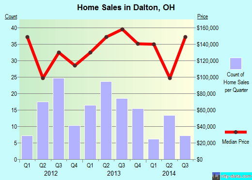
Property valuation of SW Alabama Avenue, Dalton, OH (tax assessments)

Listed properties vs overall distribution of properties in Dalton, OH:
Advertisements
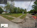
SW Alabama Avenue
Dalton, OH 44618
Find on map >>
Owner: JOSEPH T WEAVER TRUSTEE
Land value: $7,300
Total value for property: $7,300
Assessed land value: $2,560
Assessed total value for property: $2,560
Tax district: Tuscarawas Township - Tuslaw LSD
Assessments for tax year: 2010
Property use: Cauv, Agricultural Vacant Land
Property class: Agricultural
Land size: 551,034 square feet
Land type: Tillable (99%), Roadway (1%)
Transfers:
- Date: 01/25/2011
Stated value: $0
Previous owner: JOSEPH T TRUSTEE WEAVER ETAL
- Date: 08/14/2001
Stated value: $0
- Date: 02/20/1998
Stated value: $50,612
- Date: 02/20/1998
Stated value: $25,306
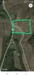
SW Alabama Avenue
Dalton, OH 44618
Find on map >>
Owner: RICKY D BECKHAM SR ETAL
Tax district: Tuscarawas Township - Tuslaw LSD
Property use: Cauv, Cash - Grain Farm
Property class: Agricultural
Land size: 493,535 square feet
Land type: Tillable (99%), Roadway (1%)
Transfers:
Dalton, OH 44618
Find on map >>
Owner: RICKY D BECKHAM SR ETAL
Tax district: Tuscarawas Township - Tuslaw LSD
Property use: Cauv, Cash - Grain Farm
Property class: Agricultural
Land size: 493,535 square feet
Land type: Tillable (99%), Roadway (1%)
Transfers:
- Date: 01/14/2013
Stated value: $0
Previous owner: REBECCA O ELLIOTT
SW Alabama Avenue
Dalton, OH 44618-9506
Find on map >>
Owner: JEFFREY D / HARVEY L AMSTUTZ REV LIVING TRUST WOODS TRUSTEE
Land value: $14,300 (it was $19,500 in 2012)
Improvement value: $5,400 (it was $3,800 in 2012)
Total value for property: $19,700 (it was $23,300 in 2012)
Assessed land value: $5,010
Assessed improvement value: $1,890
Assessed total value for property: $6,900
Tax district: Tuscarawas Township - Tuslaw LSD
Assessments for tax year: 2013
Property use: Other Residential Structures
Property class: Residential
Land size: 45,738 square feet
Land type: Excess Land (96%), Roadway (4%)
Other improvements:
- Building type: Barn, Flat
Number of stories: 1.0
Construction type: Pole
Frontage: 32 feet
Depth: 30 feet
Area: 960 square feet
Year built: 1995
Condition: Average
Value: $5,600
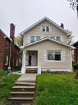
SW Alabama Avenue
Dalton, OH 44618
Find on map >>
Owner: JUDITH K / JOSEPH T WEAVER REV TRUST WEAVER TRUSTEE
Tax district: Tuscarawas Township - Tuslaw LSD
Property use: Cauv, Agricultural Vacant Land
Property class: Agricultural
Land size: 540,144 square feet
Land type: Tillable (100%), Roadway (0%)
Transfers:
Dalton, OH 44618
Find on map >>
Owner: JUDITH K / JOSEPH T WEAVER REV TRUST WEAVER TRUSTEE
Tax district: Tuscarawas Township - Tuslaw LSD
Property use: Cauv, Agricultural Vacant Land
Property class: Agricultural
Land size: 540,144 square feet
Land type: Tillable (100%), Roadway (0%)
Transfers:
- Date: 06/15/2011
Stated value: $0
Previous owner: JOSEPH T WEAVER TRUSTEE
SW Alabama Avenue
Dalton, OH 44618
Find on map >>
Owner: JOHN W FICHTER & MICHELE M FICHTER
Land value: $1,600
Total value for property: $1,600
Assessed land value: $560
Assessed total value for property: $560
Tax district: Tuscarawas Township - Tuslaw LSD
Assessments for tax year: 2010
Property use: Residential Vacant Land
Property class: Residential
Land size: 7,405 square feet
Land type: Tillable (82%), Roadway (18%)
Transfers:
- Date: 09/29/2000
Stated value: $0
SW Alabama Avenue
Dalton, OH 44618
Find on map >>
Owner: TIMOTHY R SHAFFER
Land value: $6,650
Total value for property: $6,650
Assessed land value: $2,330
Assessed total value for property: $2,330
Tax district: Tuscarawas Township - Tuslaw LSD
Assessments for tax year: 2012
Property use: Cauv, Agricultural Vacant Land
Property class: Agricultural
Land size: 442,570 square feet
Land type: Tillable (100%), Woods (0%)
SW Alabama Avenue
Dalton, OH 44618
Find on map >>
Owner: BYRON W LASH & CHERYL L LASH
Land value: $29,700
Improvement value: $167,900
Total value for property: $197,600
Assessed land value: $10,400
Assessed improvement value: $58,770
Assessed total value for property: $69,170
Tax district: Tuscarawas Township - Tuslaw LSD
Assessments for tax year: 2012
Property use: Residential Vacant Land
Property class: Residential
Land size: 20,300 square feet
Land type: Excess Land
Reason for adjusting the land value: Vacant Land
Transfers:
- Date: 10/26/2006
Stated value: $32,500
- Date: 10/06/1995
Stated value: $16,500
SW Alabama Avenue
Dalton, OH 44618
Find on map >>
Owner: TERRY A BONK & NANCY E BONK
Land value: $14,800
Total value for property: $14,800
Assessed land value: $5,180
Assessed total value for property: $5,180
Tax district: Tuscarawas Township - Tuslaw LSD
Assessments for tax year: 2012
Property use: Residential Vacant Land
Property class: Residential
Land size: 21,000 square feet
Land type: Excess Land
Reason for adjusting the land value: Vacant Land
SW Alabama Avenue
Dalton, OH 44618-9515
Find on map >>
Owner: MICHAEL B COVEY
Land value: $5,100
Total value for property: $5,100
Assessed land value: $1,790
Assessed total value for property: $1,790
Tax district: Tuscarawas Township - Tuslaw LSD
Assessments for tax year: 2012
Property use: Residential Vacant Land
Property class: Residential
Land size: 34,228 square feet
Land type: Excess Land (83%), Roadway (17%)
Reason for adjusting the land value: Vacant Land
Transfers:
- Date: 07/29/2010
Stated value: $4,650
Previous owner: CHERIE L GRAHAM
- Date: 06/25/2010
Stated value: $0
Previous owner: RALPH A GRAHAM & CHERIE L GRAHAM
SW Alabama Avenue
Dalton, OH 44618
Find on map >>
Owner: DK PROPERTY BROTHERS LLC
Land value: $2,900
Total value for property: $2,900
Assessed land value: $1,020
Assessed total value for property: $1,020
Tax district: Tuscarawas Township - Tuslaw LSD
Assessments for tax year: 2013
Property use: Residential Vacant Land
Property class: Residential
Land size: 10,890 square feet
Land type: Tillable (88%), Roadway (12%)
Transfers:
- Date: 02/19/2014
Stated value: $0
Previous owner: DEREK R SHANKLIN & KIP B SHANKLIN
- Date: 01/25/2011
Stated value: $10,000

Recent posts about Dalton, Ohio on our local forum with over 2,400,000 registered users. Dalton is mentioned 84 times on our forum:
 | CBJ Thread (52 replies) |
| Browns organization under Haslam is a cave of no return? (25 replies) |
| Whatever happened to the Industrialist families of Dayton? (151 replies) |
| Dayton Pictures Thread (151 replies) |
| Cincinnati Pictures Thread (828 replies) |
| Do you think the new Bike Transit system will work? (143 replies) |
Settings
X

Recently Added Photos
Middletown, OH
Middletown, OH

Cincinnati, OH
Cleveland, OH
Cleveland, OH
Lisbon, OH
Columbus, OH
Parma, OH

Akron, OH
Akron, OH
Cuyahoga Falls, OH
Akron, OH
Request disassociating your name from street-level assessment address

Recent home sales, price trends, and home value evaluator powered by Onboard Informatics
© 2024 Onboard Informatics. Information is deemed reliable but not guaranteed.
© 2024 Onboard Informatics. Information is deemed reliable but not guaranteed.
Some parts © 2024 Advameg, Inc.
Compilation, repackaging, or reproduction prohibited. Users are forewarned that it is incumbent upon them to verify information with the responsible state agency. Advameg, Inc. does not guarantee the data presented is up-to-date nor does it assume responsibility for updating it. Therefore any names, owners or addresses may have changed. Use of any information published here to contact the persons might be prohibited by the law.