- City-Data.com
- Washington
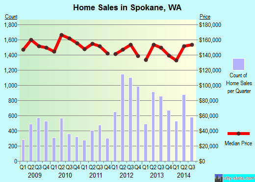
- Spokane
- Spokane County, WA property tax assessment data
Property valuation of W Mission Avenue, Spokane, WA: 1908, 1914, 1920, 1924, 1928, 2002, 2008, 2018, 2020, 2024 (tax assessments)
Listed properties vs overall distribution of properties in Spokane, WA:
1908 W Mission Avenue
Spokane, WA
Find on map >>
Owner: SPOKANE CITY OF
Land area: 7,000 square feet
Assessments for tax year: 2015
1914 W Mission Avenue
Spokane, WA
Find on map >>
Owner: SPOKANE CITY OF
Land area: 7,000 square feet
Assessments for tax year: 2015
1920 W Mission Avenue
Spokane, WA
Find on map >>
Owner: SPOKANE CITY OF
Land area: 7,000 square feet
Assessments for tax year: 2015
1924 W Mission Avenue
Spokane, WA
Find on map >>
Owner: SPOKANE CITY OF
Land area: 4,370 square feet
Assessments for tax year: 2015
1928 W Mission Avenue
Spokane, WA
Find on map >>
Owner: SPOKANE CITY OF
Land area: 5,580 square feet
Assessments for tax year: 2015
2002 W Mission Avenue
Spokane, WA
Find on map >>
Owner: SPOKANE CITY OF
Land area: 7,021 square feet
Assessments for tax year: 2015
2008 W Mission Avenue
Spokane, WA
Find on map >>
Owner: SPOKANE CITY OF
Land area: 7,023 square feet
Assessments for tax year: 2015
2018 W Mission Avenue
Spokane, WA
Find on map >>
Owner: SPOKANE CITY OF
Land area: 2,175 square feet
Assessments for tax year: 2015
2020 W Mission Avenue
Spokane, WA
Find on map >>
Owner: SPOKANE CITY OF
Land area: 7,025 square feet
Assessments for tax year: 2015
2024 W Mission Avenue
Spokane, WA
Find on map >>
Owner: SPOKANE CITY OF
Land area: 7,019 square feet
Assessments for tax year: 2015
Data:
Recently Added Photos
![]()
Spokane, WA
![]()
Spokane, WA
![]()
Spokane, WA
![]()
Spokane, WA
![]()
Spokane, WA
![]()
Spokane, WA
![]()
Spokane, WA
![]()
Spokane, WA
![]()
Spokane, WA
![]()
Spokane, WA
![]()
Spokane, WA
![]()
Spokane, WA
 W Mission Avenue