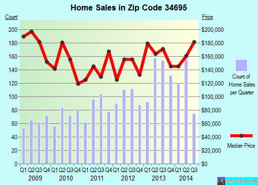
Property valuation of Kendale Drive, Safety Harbor, FL: 102, 103, 104, 105, 106, 107, 108 (tax assessments)
Other nearby streets: Country Villas Drive  Kendale Drive (1)
Kendale Drive (2)
State Road 580 (1)
State Road 580 (2)
Kendale Drive (1)
Kendale Drive (2)
State Road 580 (1)
State Road 580 (2)
Kendale Drive (1)
Kendale Drive (2)
State Road 580 (1)
State Road 580 (2)
Listed properties vs overall distribution of properties in Safety Harbor, FL:
Advertisements
Kendale Drive
Safety Harbor, FL 34695
Find on map >>
Owner: FL DEPT OF TRANS
Total land value: $37,109
Market value for property: $37,109
Millage rate: 20.0648
The amount of taxes assessed for this parcel: $744
Parcel type: Residential
Assessments for tax year: 2016
Size of the land given in width by hength: 42x122 feet
Land's use: Vacant
Land's use according to the future land use plan: Rlm - Residential Low Medium
Kendale Drive
Safety Harbor, FL 34695
Find on map >>
Owner: DEDICATED TO PUBLIC & BY PLAT BK 77 PG 7
Millage rate: 20.0648
The amount of taxes assessed for this parcel: $0
Parcel type: Residential
Assessments for tax year: 2016
Land's use: Residential Common Area
Land's use according to the future land use plan: Rlm - Residential Low Medium
Kendale Drive
Safety Harbor, FL 34695
Find on map >>
Owner: TIFFANY WEAKLEY
Total land value: $85
Market value for property: $85
Millage rate: 20.0648
The amount of taxes assessed for this parcel: $1
Parcel type: Both
Assessments for tax year: 2016
Size of the land given in width by hength: 46x121 feet
Land's use: Rights-Of-Way
Land's use according to the future land use plan: Rlm - Residential Low Medium
Sale date: 06/03/2015
Price: $193,000
Vacant or improved sale: Improved
Old owner: WILLIAM MEISNER
New owner: WEAKLEY TIFFANY
102 Kendale Drive
Safety Harbor, FL 34695
Find on map >>
Owner: RONALD SULE
Total buildings value: $85,160
Total land value: $55,813
Market value for property: $140,973
Millage rate: 20.0648
The amount of taxes assessed for this parcel: $2,828
Parcel type: Residential
Assessments for tax year: 2016
Building type: Single Family
Foundation: Continuous Footing
Floor system: Slab On Grade
Number of stories in the building: 1
The number of living units: 1
Quality factor for this building: Average
Gross area of the building: 2,120 square feet
Year property was built: 1978
Effective age: 28 years
Heating: Central Duct
Cooling type: Cooling (Central)
Size of the land given in width by hength: 70x124 feet
Land's use: Single Family
Land's use according to the future land use plan: Rlm - Residential Low Medium
Sales:
-
Sale date: 06/12/2007
Price: $180,000
Vacant or improved sale: Improved
Old owner: OLGA UNDERWOOD
New owner: CARLOS M OROZCO
-
Sale date: 10/15/2014
Price: $172,000
Vacant or improved sale: Improved
Old owner: CARLOS M OROZCO
New owner: SULE RONALD
103 Kendale Drive
Safety Harbor, FL 34695
Find on map >>
Owner: TIFFANY WEAKLEY
Total buildings value: $121,581
Total land value: $59,092
Total extra features value: $2,693
Market value for property: $183,366
Millage rate: 20.0648
The amount of taxes assessed for this parcel: $3,679
Parcel type: Residential
Assessments for tax year: 2016
Size of the land given in width by hength: 75x124 feet
Land's use: Single Family
Land's use according to the future land use plan: Rlm - Residential Low Medium
Sales:
Extra features:
Safety Harbor, FL 34695
Find on map >>
Owner: TIFFANY WEAKLEY
Total buildings value: $121,581
Total land value: $59,092
Total extra features value: $2,693
Market value for property: $183,366
Millage rate: 20.0648
The amount of taxes assessed for this parcel: $3,679
Parcel type: Residential
Assessments for tax year: 2016
Size of the land given in width by hength: 75x124 feet
Land's use: Single Family
Land's use according to the future land use plan: Rlm - Residential Low Medium
Sales:
-
Sale date: 12/14/2009
Price: $43,600
Vacant or improved sale: Improved
Old owner: DORIS R CHOQUETTE
New owner: U S BANK NA TR
-
Sale date: 03/12/2010
Price: $81,000
Vacant or improved sale: Improved
Old owner: US BANK NATL ASSN TR
New owner: SOUTH STAR EQUITY HOLDINGS INC
-
Sale date: 03/29/2010
Price: $85,000
Vacant or improved sale: Improved
Old owner: SOUTH STAR EQUITY HOLDINGS INC
New owner: MEISNER WILLIAM
-
Sale date: 06/03/2015
Price: $193,000
Vacant or improved sale: Improved
Old owner: WILLIAM MEISNER
New owner: WEAKLEY TIFFANY
Extra features:
-
Description of the extra feature: Fireplace
Value of the extra feature: $6,000
Year extra feature was added to the roll: 1977
-
Description of the extra feature: Patio/Deck
Value of the extra feature: $1,440
Year extra feature was added to the roll: 1992
104 Kendale Drive
Safety Harbor, FL 34695
Find on map >>
Owner: KIEVE MC CLOUD & LANCIA TERRY
Total buildings value: $65,825
Total land value: $56,863
Total extra features value: $493
Market value for property: $123,181
Millage rate: 20.0648
The amount of taxes assessed for this parcel: $2,471
Parcel type: Residential
Assessments for tax year: 2016
Building type: Single Family
Foundation: Continuous Footing
Floor system: Slab On Grade
Number of stories in the building: 1
The number of living units: 1
Quality factor for this building: Average
Gross area of the building: 1,848 square feet
Year property was built: 1977
Effective age: 33 years
Heating: Central Duct
Cooling type: Cooling (Central)
Size of the land given in width by hength: 70x129 feet
Land's use: Single Family
Land's use according to the future land use plan: Rlm - Residential Low Medium
Sales:
Value of the extra feature: $1,440
Year extra feature was added to the roll: 1977
Safety Harbor, FL 34695
Find on map >>
Owner: KIEVE MC CLOUD & LANCIA TERRY
Total buildings value: $65,825
Total land value: $56,863
Total extra features value: $493
Market value for property: $123,181
Millage rate: 20.0648
The amount of taxes assessed for this parcel: $2,471
Parcel type: Residential
Assessments for tax year: 2016
Building type: Single Family
Foundation: Continuous Footing
Floor system: Slab On Grade
Number of stories in the building: 1
The number of living units: 1
Quality factor for this building: Average
Gross area of the building: 1,848 square feet
Year property was built: 1977
Effective age: 33 years
Heating: Central Duct
Cooling type: Cooling (Central)
Size of the land given in width by hength: 70x129 feet
Land's use: Single Family
Land's use according to the future land use plan: Rlm - Residential Low Medium
Sales:
-
Sale date: 04/14/2006
Price: $210,000
Vacant or improved sale: Improved
Old owner: ALAN E FELDMAN
New owner: STEPHEN MARK POLING
-
Sale date: 10/27/2006
Price: $260,000
Vacant or improved sale: Improved
Old owner: STEPHEN MARK POLING
New owner: LANCIA TERRY
Value of the extra feature: $1,440
Year extra feature was added to the roll: 1977
105 Kendale Drive
Safety Harbor, FL 34695
Find on map >>
Owner: LONNIE L CHOATE & JAMIE C CHOATE
Total buildings value: $91,304
Total land value: $59,650
Total extra features value: $12,735
Market value for property: $163,689
Millage rate: 20.0648
The amount of taxes assessed for this parcel: $3,284
Parcel type: Residential
Assessments for tax year: 2016
Building type: Single Family
Foundation: Continuous Footing
Floor system: Slab On Grade
Number of stories in the building: 1
The number of living units: 1
Quality factor for this building: Average
Gross area of the building: 2,169 square feet
Year property was built: 1977
Effective age: 15 years
Heating: Central Duct
Cooling type: Cooling (Central)
Size of the land given in width by hength: 75x129 feet
Land's use: Single Family
Land's use according to the future land use plan: Rlm - Residential Low Medium
Sales:
Extra features:
Safety Harbor, FL 34695
Find on map >>
Owner: LONNIE L CHOATE & JAMIE C CHOATE
Total buildings value: $91,304
Total land value: $59,650
Total extra features value: $12,735
Market value for property: $163,689
Millage rate: 20.0648
The amount of taxes assessed for this parcel: $3,284
Parcel type: Residential
Assessments for tax year: 2016
Building type: Single Family
Foundation: Continuous Footing
Floor system: Slab On Grade
Number of stories in the building: 1
The number of living units: 1
Quality factor for this building: Average
Gross area of the building: 2,169 square feet
Year property was built: 1977
Effective age: 15 years
Heating: Central Duct
Cooling type: Cooling (Central)
Size of the land given in width by hength: 75x129 feet
Land's use: Single Family
Land's use according to the future land use plan: Rlm - Residential Low Medium
Sales:
-
Sale date: 06/17/1993
Price: $82,200
Vacant or improved sale: Improved
Old owner: THOMAS F FLYNN
New owner: MICHELE CECERE
-
Sale date: 11/23/1994
Price: $71,300
Vacant or improved sale: Improved
Old owner: MICHELE CECERE
New owner: GINA M KENNEDY
-
Sale date: 02/27/2015
Price: $216,000
Vacant or improved sale: Improved
Old owner: GINA MARIE GODUTO
New owner: CHOATE LONNIE L
Extra features:
-
Description of the extra feature: Enclosure
Value of the extra feature: $7,110
Year extra feature was added to the roll: 1977
-
Description of the extra feature: Pool
Value of the extra feature: $28,000
Year extra feature was added to the roll: 1977
-
Description of the extra feature: Fireplace
Value of the extra feature: $3,000
Year extra feature was added to the roll: 1977
106 Kendale Drive
Safety Harbor, FL 34695
Find on map >>
Owner: AMY L PATE & EUGENE M PATE
Total buildings value: $93,794
Total land value: $62,329
Total extra features value: $12,163
Market value for property: $168,286
Millage rate: 20.0648
The amount of taxes assessed for this parcel: $3,376
Parcel type: Residential
Assessments for tax year: 2016
Building type: Single Family
Foundation: Continuous Footing
Floor system: Slab On Grade
Number of stories in the building: 1
The number of living units: 1
Quality factor for this building: Average
Gross area of the building: 2,169 square feet
Year property was built: 1977
Effective age: 28 years
Heating: Central Duct
Cooling type: Cooling (Central)
Size of the land given in width by hength: 70x132 feet
Land's use: Single Family
Land's use according to the future land use plan: Rlm - Residential Low Medium
Sales:
Extra features:
Safety Harbor, FL 34695
Find on map >>
Owner: AMY L PATE & EUGENE M PATE
Total buildings value: $93,794
Total land value: $62,329
Total extra features value: $12,163
Market value for property: $168,286
Millage rate: 20.0648
The amount of taxes assessed for this parcel: $3,376
Parcel type: Residential
Assessments for tax year: 2016
Building type: Single Family
Foundation: Continuous Footing
Floor system: Slab On Grade
Number of stories in the building: 1
The number of living units: 1
Quality factor for this building: Average
Gross area of the building: 2,169 square feet
Year property was built: 1977
Effective age: 28 years
Heating: Central Duct
Cooling type: Cooling (Central)
Size of the land given in width by hength: 70x132 feet
Land's use: Single Family
Land's use according to the future land use plan: Rlm - Residential Low Medium
Sales:
-
Sale date: 08/30/1988
Price: $85,900
-
Sale date: 03/30/2011
Price: $144,000
Vacant or improved sale: Improved
Old owner: MARYANN BOUTIN
New owner: PATE EUGENE M
Extra features:
-
Description of the extra feature: Enclosure
Value of the extra feature: $7,110
Year extra feature was added to the roll: 1977
-
Description of the extra feature: Pool
Value of the extra feature: $28,000
Year extra feature was added to the roll: 1977
-
Description of the extra feature: Patio/Deck
Value of the extra feature: $900
Year extra feature was added to the roll: 1977
107 Kendale Drive
Safety Harbor, FL 34695
Find on map >>
Owner: DEBBIE L KELLY & DENNIS J KELLY
Total buildings value: $94,172
Total land value: $66,559
Total extra features value: $17,836
Market value for property: $178,567
Millage rate: 20.0648
The amount of taxes assessed for this parcel: $3,582
Parcel type: Residential
Assessments for tax year: 2016
Building type: Single Family
Foundation: Continuous Footing
Floor system: Slab On Grade
Number of stories in the building: 1
The number of living units: 1
Quality factor for this building: Average
Gross area of the building: 2,496 square feet
Year property was built: 1978
Effective age: 33 years
Heating: Central Duct
Cooling type: Cooling (Central)
Size of the land given in width by hength: 75x131 feet
Land's use: Single Family
Land's use according to the future land use plan: Rlm - Residential Low Medium
Extra features:
-
Description of the extra feature: Enclosure
Value of the extra feature: $11,260
Year extra feature was added to the roll: 2003
-
Description of the extra feature: Pool
Value of the extra feature: $28,000
Year extra feature was added to the roll: 1978
-
Description of the extra feature: Patio/Deck
Value of the extra feature: $2,520
Year extra feature was added to the roll: 1978
-
Description of the extra feature: Shed
Value of the extra feature: $1,800
Year extra feature was added to the roll: 2001
108 Kendale Drive
Safety Harbor, FL 34695
Find on map >>
Owner: MYRNA D TRE PERLMAN
Total buildings value: $105,497
Total land value: $62,555
Total extra features value: $488
Market value for property: $168,540
Millage rate: 20.0648
The amount of taxes assessed for this parcel: $3,381
Parcel type: Residential
Assessments for tax year: 2016
Building type: Single Family
Foundation: Continuous Footing
Floor system: Slab On Grade
Number of stories in the building: 1
The number of living units: 1
Quality factor for this building: Average
Gross area of the building: 1,981 square feet
Year property was built: 1977
Effective age: 23 years
Heating: Central Duct
Cooling type: Cooling (Central)
Size of the land given in width by hength: 70x132 feet
Land's use: Single Family
Land's use according to the future land use plan: Rlm - Residential Low Medium
Description of the extra feature: Patio/Deck
Value of the extra feature: $1,440
Year extra feature was added to the roll: 1977
Other nearby streets: Country Villas Drive
Kendale Drive (1)
Kendale Drive (2)
State Road 580 (1)
State Road 580 (2)
Kendale Drive (1)
Kendale Drive (2)
State Road 580 (1)
State Road 580 (2)

Recent posts about Safety Harbor, Florida on our local forum with over 2,400,000 registered users. Safety Harbor is mentioned 3,086 times on our forum:
 | Safety Harbor vs. East Lake vs. Palm Harbor (27 replies) |
| Safety Harbor Input (14 replies) |
| Thinking about a house in Safety Harbor. (7 replies) |
| 2019 Train Noise in Safety Harbor? (9 replies) |
| New Port Richey, Palm Harbor or Dunedin (68 replies) |
| Safety Harbor vs. Gulfport (8 replies) |
Settings
X

Recently Added Photos

Brandon, FL
Valrico, FL
Punta Gorda, FL

Titusville, FL

Plant City, FL
Port Orange, FL
Mexico Beach, FL
Rockledge, FL
Port Charlotte, FL
Port Charlotte, FL
Tampa, FL
Green Cove Springs, FL
Request disassociating your name from street-level assessment address

Recent home sales, price trends, and home value evaluator powered by Onboard Informatics
© 2024 Onboard Informatics. Information is deemed reliable but not guaranteed.
© 2024 Onboard Informatics. Information is deemed reliable but not guaranteed.
Some parts © 2024 Advameg, Inc.
Compilation, repackaging, or reproduction prohibited. Users are forewarned that it is incumbent upon them to verify information with the responsible state agency. Advameg, Inc. does not guarantee the data presented is up-to-date nor does it assume responsibility for updating it. Therefore any names, owners or addresses may have changed. Use of any information published here to contact the persons might be prohibited by the law.