The Heights (Jersey City Heights) neighborhood in Jersey City, New Jersey (NJ), 07306, 07307 detailed profile
Settings
X

Business Search - 14 Million verified businesses
Area: 1.565 square miles
Population: 51,528
Population density:
| The Heights (Jersey City Heights): | 32,924 people per square mile |
| Jersey City: | 19,218 people per square mile |

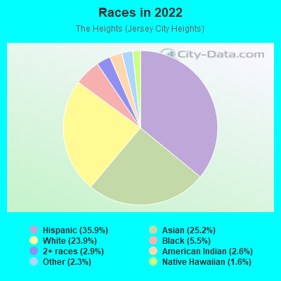
- 19,79835.9%Hispanic or Latino
- 13,89725.2%Asian
- 13,18323.9%White
- 3,0425.5%Black
- 1,5962.9%Two or more races
- 1,4292.6%American Indian
- 1,2872.3%Some other race
- 8651.6%Native Hawaiian and Other
Pacific Islander
Distribution of median household income
![Distribution of median household income]()
- 1,258Less than $10,000
- 2,634$10,000 to $19,999
- 1,961$20,000 to $29,999
- 2,855$30,000 to $39,999
- 2,044$40,000 to $49,999
- 2,069$50,000 to $59,999
- 1,550$60,000 to $74,999
- 2,825$75,000 to $99,999
- 1,921$100,000 to $124,999
- 2,316$125,000 to $149,999
- 2,212$150,000 to $199,999
- 2,562$200,000 or more

Distribution of owner-occupied house/condo value
![Distribution of owner-occupied house/condo value]()
- 1,985Less than $50,000
- 2,289$50,000 to $99,999
- 2,357$100,000 to $149,999
- 936$150,000 to $199,999
- 719$200,000 to $249,999
- 777$250,000 to $299,999
- 1,183$300,000 to $399,999
- 1,162$400,000 to $499,999
- 2,221$500,000 to $749,999
- 1,280$750,000 to $999,999
- 1,699$1,000,000 or more

Distribution of rent paid by renters
![Distribution of rent paid by renters]()
- 1,116Less than $100
- 3,341$100 to $199
- 1,339$200 to $299
- 1,619$300 to $399
- 3,468$400 to $499
- 2,069$500 to $599
- 2,273$600 to $699
- 1,490$700 to $799
- 1,015$800 to $899
- 1,168$900 to $999
- 2,783$1,000 to $1,249
- 3,090$1,250 to $1,499
- 4,120$1,500 to $1,999
- 4,112$2,000 or more

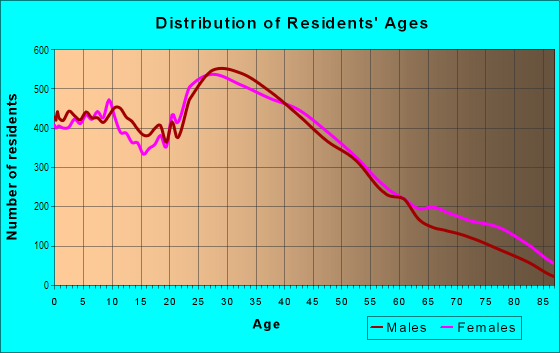
| Males: | 26,492 |
| Females: | 25,035 |
Males:
| This neighborhood: | 35.7 years |
| Whole city: | 34.1 years |
| This neighborhood: | 38.5 years |
| Whole city: | 36.2 years |
Average household size:
| The Heights (Jersey City Heights): | 5.8 people |
| Jersey City: | 2.2 people |
Percentage of family households:
| The Heights (Jersey City Heights): | 45.4% |
| Jersey City: | 39.8% |
| Here: | 39.1% |
| Jersey City: | 34.2% |
Percentage of married-couple families with children (among all households):
| The Heights (Jersey City Heights): | 32.2% |
| Jersey City: | 29.4% |
Percentage of single-mother households (among all households):
| The Heights (Jersey City Heights): | 9.9% |
| Jersey City: | 13.3% |
Percentage of never married males 15 years old and over:
Percentage of never married females 15 years old and over:
| The Heights (Jersey City Heights): | 23.4% |
| Jersey City: | 23.6% |
Percentage of never married females 15 years old and over:
| The Heights (Jersey City Heights): | 17.2% |
| city: | 22.6% |
Percentage of people that speak English not well or not at all:
| The Heights (Jersey City Heights): | 11.2% |
| Jersey City: | 7.2% |
Percentage of people born in this state:
Percentage of people born in another U.S. state:
Percentage of native residents but born outside the U.S.:
Percentage of foreign born residents:
| Here: | 34.0% |
| Jersey City: | 34.5% |
Percentage of people born in another U.S. state:
| The Heights (Jersey City Heights): | 15.9% |
| Jersey City: | 22.1% |
Percentage of native residents but born outside the U.S.:
| Here: | 4.3% |
| city: | 3.8% |
Percentage of foreign born residents:
| Here: | 45.7% |
| Jersey City: | 39.6% |
Owner-occupied
Renter-occupied

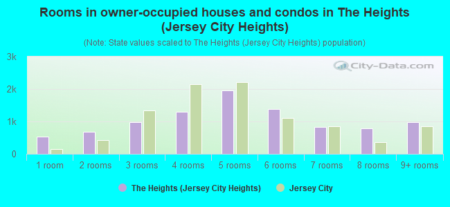
- Rooms in owner-occupied houses and condos in The Heights <
> - 5421 room
- 6732 rooms
- 9893 rooms
- 1,3004 rooms
- 1,9645 rooms
- 1,3876 rooms
- 8317 rooms
- 7868 rooms
- 9729+ rooms
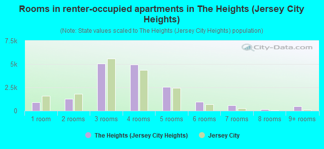
- Rooms in renter-occupied apartments in The Heights <
> - 8801 room
- 1,2632 rooms
- 5,0673 rooms
- 4,9244 rooms
- 2,5335 rooms
- 9386 rooms
- 5937 rooms
- 1798 rooms
- 4979+ rooms
Owner-occupied
Renter-occupied
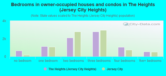
- Bedrooms in owner-occupied houses and condos in The Heights <
> - 647no bedroom
- 1,1401 bedroom
- 2,0922 bedrooms
- 2,7713 bedrooms
- 1,0604 bedrooms
- 5365+ bedrooms
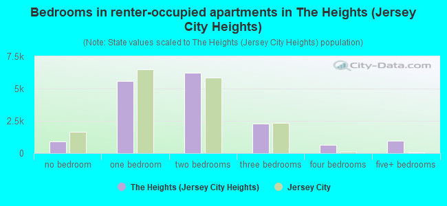
- Bedrooms in renter-occupied apartments in The Heights <
> - 888no bedroom
- 5,5771 bedroom
- 6,2032 bedrooms
- 2,2953 bedrooms
- 6484 bedrooms
- 9365+ bedrooms
Average number of cars or other vehicles available in houses/condos:
Average number of cars or other vehicles available in apartments:
| This neighborhood: | |
| Jersey City: |
Average number of cars or other vehicles available in apartments:
| Here: | 0.7 |
| city: | 0.6 |
Percentage of units with a mortgage:
| The Heights (Jersey City Heights): | 63.1% |
| Jersey City: | 69.4% |
Average estimated value of housing units in 2-unit structures in 2022 (29.6% of all units):
| This neighborhood: | $115,716 |
| Jersey City: | $571,976 |
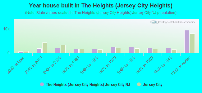
- Year house built in The Heights <
> - 4842020 or later
- 1,8022010 to 2019
- 2,1442000 to 2009
- 1,6101990 to 1999
- 1,6041980 to 1989
- 2,4811970 to 1979
- 2,4371960 to 1969
- 2,1271950 to 1959
- 2,0881940 to 1949
- 9,4871939 or earlier
City-data.com crime index for city in 2020 (higher means more crime):
| City: | 198.8 |
| U.S. average: | 219.5 |
Travel time to work (commute)
![Travel time to work (commute)]()
- 549Less than 5 minutes
- 7305 to 9 minutes
- 1,51910 to 14 minutes
- 2,24715 to 19 minutes
- 2,87820 to 24 minutes
- 92325 to 29 minutes
- 3,74630 to 34 minutes
- 65635 to 39 minutes
- 1,55340 to 44 minutes
- 4,49945 to 59 minutes
- 3,85360 to 89 minutes
- 73790 or more minutes

Means of transportation to work
![Means of transportation to work]()
- 33.3%9,016Drove a car alone
- 8.1%2,185Carpooled
- 18.6%5,033Bus
- 12.7%3,447Subway or elevated rail
- 2.3%635Long-distance train or commuter rail
- 3.1%834Light rail, streetcar or trolley
- 1.5%407Ferryboat
- 3.1%827Taxi
- 2.9%776Bicycle
- 6.9%1,858Walked
- 3.2%860Other means
- 16.2%4,389Worked at home

Time leaving home to go to work
![Time leaving home to go to work]()
- 1,10912:00 a.m. to 4:59 a.m.
- 9765:00 a.m. to 5:29 a.m.
- 6625:30 a.m. to 5:59 a.m.
- 1,5096:00 a.m. to 6:29 a.m.
- 1,2916:30 a.m. to 6:59 a.m.
- 2,4907:00 a.m. to 7:29 a.m.
- 2,7387:30 a.m. to 7:59 a.m.
- 5,5828:00 a.m. to 8:29 a.m.
- 1,5728:30 a.m. to 8:59 a.m.
- 2,0329:00 a.m. to 9:59 a.m.
- 1,16910:00 a.m. to 10:59 a.m.
- 45411:00 a.m. to 11:59 a.m.
- 1,29912:00 p.m. to 3:59 p.m.
- 8924:00 p.m. to 11:59 p.m.

Occupations of males:
- Percentage of males in management occupations (except farmers):
Here: 9.3% city: 12.9%
- Percentage of males in business and financial operations occupations:
Here: 8.1% city: 9.9%
- Percentage of males in computer and mathematical occupations:
Here: 13.0% city: 13.5%
- Percentage of males in architecture and engineering occupations:
Here: 3.4% city: 3.7%
- Percentage of males in life, physical, and social science occupations:
Here: 1.8% city: 1.1%
- Percentage of males in legal occupations:
Here: 1.4% city: 1.8%
- Percentage of males in education, training, and library occupations:
Here: 2.5% city: 3.6%
- Percentage of males in arts, design, entertainment, sports, and media occupations:
Here: 3.4% city: 3.5%
- Percentage of males in healthcare practitioners and technical occupations:
Here: 2.1% city: 2.6%
- Percentage of males in service occupations:
Here: 11.3% city: 10.4%
- Percentage of males in sales and office occupations:
Here: 13.2% city: 13.4%
- Percentage of males in construction, extraction, and maintenance occupations:
Here: 7.0% city: 5.6%
- Percentage of males in production occupations:
Here: 3.2% city: 2.8%
- Percentage of males in transportation occupations:
Here: 10.3% city: 7.2%
- Percentage of males in material moving occupations:
Here: 5.6% city: 4.2%
Occupations of females:
- Percentage of females in management occupations (except farmers):
Here: 10.9% city: 11.5%
- Percentage of females in business and financial operations occupations:
Here: 8.7% city: 11.7%
- Percentage of females in computer and mathematical occupations:
Here: 3.6% city: 5.3%
- Percentage of females in community and social services occupations:
Here: 2.8% city: 2.2%
- Percentage of females in legal occupations:
Here: 4.1% city: 2.6%
- Percentage of females in education, training, and library occupations:
Here: 6.7% city: 8.3%
- Percentage of females in arts, design, entertainment, sports, and media occupations:
Here: 4.8% city: 4.9%
- Percentage of females in healthcare practitioners and technical occupations:
Here: 5.0% city: 6.5%
- Percentage of females in service occupations:
Here: 21.4% city: 17.9%
- Percentage of females in sales and office occupations:
Here: 23.9% city: 21.2%
- Percentage of females in production occupations:
Here: 3.5% city: 2.7%
- Percentage of females in material moving occupations:
Here: 2.2% city: 1.8%
Percentage of people 16-64 in Armed Forces:
| The Heights (Jersey City Heights): | 0.1% |
| Jersey City: | 0.1% |
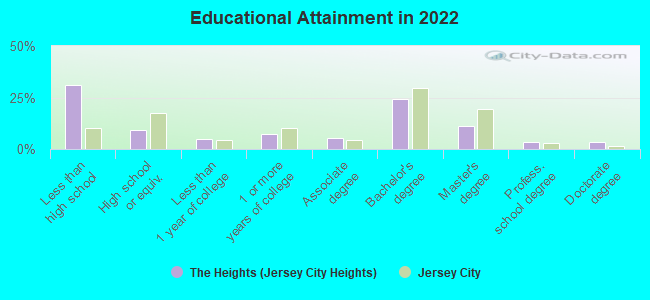
Education in this neighborhood (subdivision or community):
- Percentage of people 3 years and older in K-12 schools:
The Heights (Jersey City Heights): 20.0% Jersey City: 12.9%
- Percentage of people 3 years and older in undergraduate colleges:
The Heights (Jersey City Heights): 5.2% Jersey City: 4.5%
- Percentage of people 3 years and older in grad. or professional schools:
The Heights (Jersey City Heights): 3.7% Jersey City: 2.2%
- Percentage of students K-12 enrolled in private schools:
The Heights (Jersey City Heights): 81.4% Jersey City: 10.8%
Percentage of population below poverty level:
| The Heights (Jersey City Heights): | 12.8% |
| Jersey City: | 12.8% |
Median year owner moved in (as recorded in 2022):
Median year renter moved in (as recorded in 2022):
| The Heights (Jersey City Heights): | 2006 |
| Jersey City: | 2010 |
Median year renter moved in (as recorded in 2022):
| The Heights (Jersey City Heights): | 2014 |
| Jersey City: | 2019 |
Percentage of married-couple families with both working:
| The Heights (Jersey City Heights): | 61.5% |
| Jersey City: | 63.9% |
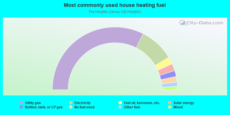
- 64.9%Utility gas
- 17.8%Electricity
- 3.8%Fuel oil, kerosene, etc.
- 3.7%Solar energy
- 3.0%Bottled, tank, or LP gas
- 2.9%No fuel used
- 2.2%Other fuel
- 1.7%Wood
Limited-access highways (interstate or state) in this neighborhood:
State Rte 139 (Hoboken Ave)
Length: 1.12 miles
Directions: E-W, N-S, SE-NW, SW-NE
Address range: 1 to 274
Directions: E-W, N-S, SE-NW, SW-NE
Address range: 1 to 274
Pulaski Skwy (State Rte 139)
Length: 0.14 miles
Directions: E-W, SE-NW
Directions: E-W, SE-NW
Highways in this neighborhood:
State Rte 501 (John F Kennedy Blvd)
Length: 1.69 miles
Directions: E-W, SW-NE
Address range: 3129 to 3700
Directions: E-W, SW-NE
Address range: 3129 to 3700
US Hwy 9 (US Hwy 1, Tonnelle Ave)
Length: 0.09 miles
Direction: SW-NE
Address range: 266 to 299
Direction: SW-NE
Address range: 266 to 299
Roads and streets:
Summit Ave
Length: 1.63 miles
Directions: N-S, SW-NE
Address range: 661 to 1199
Directions: N-S, SW-NE
Address range: 661 to 1199
Co Rd 663 (Central Ave)
Length: 1.59 miles
Direction: SW-NE
Address range: 23 to 599
Direction: SW-NE
Address range: 23 to 599
Palisade Ave
Length: 1.56 miles
Direction: SW-NE
Address range: 66 to 647
Direction: SW-NE
Address range: 66 to 647
Liberty Ave
Length: 1.43 miles
Directions: N-S, SW-NE
Address range: 138 to 611
Directions: N-S, SW-NE
Address range: 138 to 611
New York Ave (Co Rd 671)
Length: 1.32 miles
Directions: E-W, N-S, SE-NW, SW-NE
Address range: 1 to 439
Directions: E-W, N-S, SE-NW, SW-NE
Address range: 1 to 439
Co Rd 681 (Paterson Plank Rd)
Length: 1.18 miles
Directions: E-W, N-S, SE-NW, SW-NE
Address range: 1 to 520
Directions: E-W, N-S, SE-NW, SW-NE
Address range: 1 to 520
Webster Ave (Co Rd 669)
Length: 1.13 miles
Direction: SW-NE
Address range: 1 to 398
Direction: SW-NE
Address range: 1 to 398
North St
Length: 1.02 miles
Direction: E-W
Address range: 1 to 286
Direction: E-W
Address range: 1 to 286
Terrace Ave (Co Rd 649)
Length: 1.02 miles
Directions: E-W, SW-NE
Address range: 1 to 377
Directions: E-W, SW-NE
Address range: 1 to 377
Ogden Ave
Length: 0.98 miles
Direction: SW-NE
Address range: 18 to 476
Direction: SW-NE
Address range: 18 to 476
Hutton St
Length: 0.98 miles
Direction: E-W
Address range: 1 to 280
Direction: E-W
Address range: 1 to 280
Congress St
Length: 0.94 miles
Direction: E-W
Address range: 1 to 238
Direction: E-W
Address range: 1 to 238
Griffith St
Length: 0.94 miles
Direction: E-W
Address range: 25 to 299
Direction: E-W
Address range: 25 to 299
Bowers St
Length: 0.93 miles
Direction: E-W
Address range: 26 to 269
Direction: E-W
Address range: 26 to 269
Manhattan Ave
Length: 0.92 miles
Directions: E-W, SE-NW
Address range: 1 to 286
Directions: E-W, SE-NW
Address range: 1 to 286
South St
Length: 0.89 miles
Directions: E-W, SE-NW
Address range: 1 to 256
Directions: E-W, SE-NW
Address range: 1 to 256
Sherman Ave
Length: 0.88 miles
Direction: SW-NE
Address range: 3 to 327
Direction: SW-NE
Address range: 3 to 327
Beacon Ave
Length: 0.87 miles
Directions: E-W, SE-NW
Address range: 1 to 267
Directions: E-W, SE-NW
Address range: 1 to 267
Columbia Ave
Length: 0.82 miles
Direction: SW-NE
Address range: 3 to 298
Direction: SW-NE
Address range: 3 to 298
Laidlaw Ave
Length: 0.79 miles
Directions: E-W, SE-NW
Address range: 1 to 250
Directions: E-W, SE-NW
Address range: 1 to 250
Cambridge Ave (Co Rd 665)
Length: 0.78 miles
Directions: E-W, SW-NE
Address range: 1 to 806
Directions: E-W, SW-NE
Address range: 1 to 806
Hancock Ave (Co Rd 667)
Length: 0.78 miles
Directions: E-W, SW-NE
Address range: 1 to 287
Directions: E-W, SW-NE
Address range: 1 to 287
Hopkins Ave
Length: 0.77 miles
Directions: E-W, SE-NW, SW-NE
Address range: 1 to 299
Directions: E-W, SE-NW, SW-NE
Address range: 1 to 299
Zabriskie St (Co Rd 652)
Length: 0.73 miles
Directions: E-W, SE-NW
Address range: 1 to 218
Directions: E-W, SE-NW
Address range: 1 to 218
Lincoln St
Length: 0.73 miles
Direction: E-W
Address range: 1 to 207
Direction: E-W
Address range: 1 to 207
Bleecker St
Length: 0.70 miles
Directions: E-W, SE-NW
Address range: 1 to 184
Directions: E-W, SE-NW
Address range: 1 to 184
Thorne St
Length: 0.68 miles
Directions: E-W, SE-NW
Address range: 1 to 215
Directions: E-W, SE-NW
Address range: 1 to 215
Leonard St (Co Rd 668)
Length: 0.66 miles
Direction: E-W
Address range: 1 to 299
Direction: E-W
Address range: 1 to 299
St Pauls Ave
Length: 0.60 miles
Direction: SE-NW
Address range: 1 to 198
Direction: SE-NW
Address range: 1 to 198
Jefferson Ave
Length: 0.60 miles
Directions: E-W, SE-NW
Address range: 1 to 581
Directions: E-W, SE-NW
Address range: 1 to 581
Reservoir Ave
Length: 0.56 miles
Directions: E-W, SE-NW
Address range: 1 to 183
Directions: E-W, SE-NW
Address range: 1 to 183
Nelson Ave (Co Rd 659)
Length: 0.51 miles
Direction: SW-NE
Address range: 1 to 199
Direction: SW-NE
Address range: 1 to 199
Sherman Pl
Length: 0.49 miles
Direction: E-W
Address range: 1 to 145
Direction: E-W
Address range: 1 to 145
Franklin St
Length: 0.48 miles
Directions: E-W, N-S, SE-NW
Address range: 24 to 160
Directions: E-W, N-S, SE-NW
Address range: 24 to 160
Charles St
Length: 0.48 miles
Direction: E-W
Address range: 1 to 148
Direction: E-W
Address range: 1 to 148
Poplar St (Co Rd 666)
Length: 0.47 miles
Direction: E-W
Address range: 1 to 156
Direction: E-W
Address range: 1 to 156
Grace St
Length: 0.47 miles
Direction: E-W
Address range: 1 to 166
Direction: E-W
Address range: 1 to 166
Irving St
Length: 0.47 miles
Direction: E-W
Address range: 1 to 154
Direction: E-W
Address range: 1 to 154
Graham St
Length: 0.47 miles
Direction: E-W
Address range: 1 to 154
Direction: E-W
Address range: 1 to 154
Prospect St (Co Rd 654)
Length: 0.47 miles
Direction: SE-NW
Address range: 1 to 199
Direction: SE-NW
Address range: 1 to 199
Baldwin Ave
Length: 0.45 miles
Directions: N-S, SW-NE
Address range: 375 to 527
Directions: N-S, SW-NE
Address range: 375 to 527
Hague St
Length: 0.44 miles
Direction: E-W
Address range: 1 to 198
Direction: E-W
Address range: 1 to 198
Paterson St
Length: 0.43 miles
Direction: E-W
Address range: 1 to 133
Direction: E-W
Address range: 1 to 133
Oakland Ave (Co Rd 644)
Length: 0.42 miles
Direction: SW-NE
Address range: 58 to 199
Direction: SW-NE
Address range: 58 to 199
Carlton Ave (Co Rd 718)
Length: 0.42 miles
Directions: E-W, SE-NW
Address range: 1 to 134
Directions: E-W, SE-NW
Address range: 1 to 134
Waverly St
Length: 0.40 miles
Directions: SE-NW, SW-NE
Address range: 1 to 130
Directions: SE-NW, SW-NE
Address range: 1 to 130
Co Rd 660 (Ferry St)
Length: 0.39 miles
Directions: E-W, SE-NW
Address range: 21 to 149
Directions: E-W, SE-NW
Address range: 21 to 149
Fleet St
Length: 0.38 miles
Direction: SE-NW
Address range: 1 to 99
Direction: SE-NW
Address range: 1 to 99
Beach St
Length: 0.38 miles
Direction: E-W
Address range: 1 to 128
Direction: E-W
Address range: 1 to 128
Booraem Ave (Co Rd 658)
Length: 0.38 miles
Directions: N-S, SE-NW
Address range: 21 to 166
Directions: N-S, SE-NW
Address range: 21 to 166
Mountain Rd (Co Rd 731)
Length: 0.38 miles
Directions: E-W, N-S, SE-NW, SW-NE
Address range: 20 to 160
Directions: E-W, N-S, SE-NW, SW-NE
Address range: 20 to 160
Sanford Pl
Length: 0.36 miles
Directions: N-S, SE-NW
Address range: 1 to 119
Directions: N-S, SE-NW
Address range: 1 to 119
Collard St
Length: 0.33 miles
Directions: E-W, N-S, SE-NW, SW-NE
Address range: 48 to 143
Directions: E-W, N-S, SE-NW, SW-NE
Address range: 48 to 143
Western Ave
Length: 0.30 miles
Direction: SW-NE
Address range: 1 to 168
Direction: SW-NE
Address range: 1 to 168
Lake St
Length: 0.29 miles
Direction: E-W
Address range: 43 to 143
Direction: E-W
Address range: 43 to 143
Spruce St
Length: 0.26 miles
Direction: E-W
Address range: 1 to 70
Direction: E-W
Address range: 1 to 70
Ravine Ave
Length: 0.22 miles
Direction: SE-NW
Address range: 1 to 60
Direction: SE-NW
Address range: 1 to 60
Concord St
Length: 0.20 miles
Direction: SW-NE
Address range: 7 to 72
Direction: SW-NE
Address range: 7 to 72
Lineau Pl
Length: 0.20 miles
Direction: SW-NE
Address range: 1 to 56
Direction: SW-NE
Address range: 1 to 56
Montrose Ave (Co Rd 661)
Length: 0.19 miles
Directions: SE-NW, SW-NE
Address range: 1 to 63
Directions: SE-NW, SW-NE
Address range: 1 to 63
Milton Ave
Length: 0.16 miles
Direction: SW-NE
Address range: 1 to 48
Direction: SW-NE
Address range: 1 to 48
Pierce Ave
Length: 0.15 miles
Direction: SW-NE
Address range: 1 to 57
Direction: SW-NE
Address range: 1 to 57
Passaic Ave
Length: 0.15 miles
Direction: SW-NE
Address range: 1 to 48
Direction: SW-NE
Address range: 1 to 48
Stagg St
Length: 0.13 miles
Direction: SE-NW
Address range: 1 to 46
Direction: SE-NW
Address range: 1 to 46
Cliff St
Length: 0.13 miles
Direction: E-W
Address range: 1 to 48
Direction: E-W
Address range: 1 to 48
Co Rd 650 (Troy St)
Length: 0.12 miles
Directions: E-W, SE-NW
Address range: 1 to 40
Directions: E-W, SE-NW
Address range: 1 to 40
Montague Pl
Length: 0.11 miles
Directions: E-W, SE-NW
Address range: 1 to 41
Directions: E-W, SE-NW
Address range: 1 to 41
Nardone Pl
Length: 0.11 miles
Direction: SE-NW
Address range: 1 to 62
Direction: SE-NW
Address range: 1 to 62
Holland Plank Rd
Length: 0.09 miles
Directions: E-W, SW-NE
Directions: E-W, SW-NE
Floyd St
Length: 0.09 miles
Direction: SE-NW
Address range: 10 to 34
Direction: SE-NW
Address range: 10 to 34
Monmouth St
Length: 0.09 miles
Direction: N-S
Direction: N-S
Hope St
Length: 0.09 miles
Direction: SW-NE
Address range: 2 to 33
Direction: SW-NE
Address range: 2 to 33
Elm St
Length: 0.08 miles
Direction: SE-NW
Address range: 1 to 19
Direction: SE-NW
Address range: 1 to 19
Perry St
Length: 0.07 miles
Direction: SW-NE
Address range: 23 to 54360
Direction: SW-NE
Address range: 23 to 54360
Abbett St
Length: 0.07 miles
Direction: SW-NE
Address range: 1 to 31
Direction: SW-NE
Address range: 1 to 31
Nesbitt Ave (Nesbitt St)
Length: 0.07 miles
Direction: SW-NE
Address range: 1 to 22
Direction: SW-NE
Address range: 1 to 22
Reserve Ave
Length: 0.07 miles
Direction: E-W
Address range: 1 to 19
Direction: E-W
Address range: 1 to 19
Hobson St
Length: 0.06 miles
Direction: E-W
Address range: 1 to 17
Direction: E-W
Address range: 1 to 17
Hill St
Length: 0.06 miles
Direction: SE-NW
Address range: 1 to 20
Direction: SE-NW
Address range: 1 to 20
Wood Pl
Length: 0.06 miles
Direction: E-W
Address range: 1 to 20
Direction: E-W
Address range: 1 to 20
Cuneo Pl
Length: 0.06 miles
Direction: E-W
Address range: 1 to 19
Direction: E-W
Address range: 1 to 19
Bevan St
Length: 0.05 miles
Direction: N-S
Address range: 66 to 82
Direction: N-S
Address range: 66 to 82
Co Rd 663
Length: 0.05 miles
Direction: SW-NE
Direction: SW-NE
Co Rd 731
Length: 0.04 miles
Directions: E-W, SW-NE
Directions: E-W, SW-NE
Railroad features:
New Jersey Transit RR
Length: 0.40 miles
Direction: SW-NE
Direction: SW-NE
Csx RR (Penn Central RR)
Length: 0.34 miles
Directions: E-W, SW-NE
Directions: E-W, SW-NE
Norfolk Southern Rlwy
Length: 0.28 miles
Directions: E-W, SE-NW
Directions: E-W, SE-NW
Central Railroad of New Jersey
Length: 0.28 miles
Directions: E-W, N-S, SW-NE
Directions: E-W, N-S, SW-NE
Norfolk Southern Rlwy (Conrail RR)
Length: 0.08 miles
Direction: E-W
Direction: E-W