Taku (Campbell) neighborhood in Anchorage, Alaska (AK), 99515, 99518 detailed profile
Settings
X


Business Search - 14 Million verified businesses
Area: 4.561 square miles
Population: 12,387
Population density:
| Taku (Campbell): | 2,716 people per square mile |
| Anchorage: | 169 people per square mile |

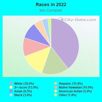
- 5,87439.6%White
- 2,34715.8%Hispanic or Latino
- 2,05813.9%Two or more races
- 1,61310.9%Native Hawaiian and Other
Pacific Islander - 1,4059.5%Asian
- 7405.0%American Indian
- 5333.6%Black
- 2681.8%Some other race
Distribution of median household income
![Distribution of median household income]()
- 210Less than $10,000
- 1,168$10,000 to $19,999
- 892$20,000 to $29,999
- 727$30,000 to $39,999
- 995$40,000 to $49,999
- 536$50,000 to $59,999
- 532$60,000 to $74,999
- 679$75,000 to $99,999
- 921$100,000 to $124,999
- 361$125,000 to $149,999
- 612$150,000 to $199,999
- 337$200,000 or more

Distribution of owner-occupied house/condo value
![Distribution of owner-occupied house/condo value]()
- 2,804Less than $50,000
- 1,674$50,000 to $99,999
- 2,905$100,000 to $149,999
- 910$150,000 to $199,999
- 243$200,000 to $249,999
- 777$250,000 to $299,999
- 828$300,000 to $399,999
- 438$400,000 to $499,999
- 507$500,000 to $749,999
- 144$750,000 to $999,999
- 35$1,000,000 or more

Distribution of rent paid by renters
![Distribution of rent paid by renters]()
- 244Less than $100
- 496$100 to $199
- 506$300 to $399
- 459$400 to $499
- 386$500 to $599
- 233$600 to $699
- 331$700 to $799
- 540$800 to $899
- 235$900 to $999
- 588$1,000 to $1,249
- 492$1,250 to $1,499
- 853$1,500 to $1,999
- 777$2,000 or more

| Males: | 6,249 |
| Females: | 6,138 |
Males:
| This neighborhood: | 34.9 years |
| Whole city: | 34.8 years |
| This neighborhood: | 34.6 years |
| Whole city: | 36.0 years |
Average household size:
| Taku (Campbell): | 6.7 people |
| Anchorage: | 2.5 people |
Percentage of family households:
| Taku (Campbell): | 51.1% |
| Anchorage: | 49.0% |
| Here: | 41.3% |
| Anchorage: | 45.5% |
Percentage of married-couple families with children (among all households):
| Taku (Campbell): | 26.5% |
| Anchorage: | 23.6% |
Percentage of single-mother households (among all households):
| Taku (Campbell): | 14.3% |
| Anchorage: | 10.8% |
Percentage of never married males 15 years old and over:
Percentage of never married females 15 years old and over:
| Taku (Campbell): | 20.3% |
| Anchorage: | 20.0% |
Percentage of never married females 15 years old and over:
| Taku (Campbell): | 16.8% |
| city: | 15.3% |
Percentage of people that speak English not well or not at all:
| Taku (Campbell): | 3.5% |
| Anchorage: | 2.1% |
Percentage of people born in this state:
Percentage of people born in another U.S. state:
Percentage of native residents but born outside the U.S.:
Percentage of foreign born residents:
| Here: | 43.0% |
| Anchorage: | 40.3% |
Percentage of people born in another U.S. state:
| Taku (Campbell): | 44.9% |
| Anchorage: | 46.0% |
Percentage of native residents but born outside the U.S.:
| Here: | 2.2% |
| city: | 3.4% |
Percentage of foreign born residents:
| Here: | 10.0% |
| Anchorage: | 10.4% |
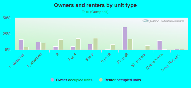
Owner-occupied
Renter-occupied

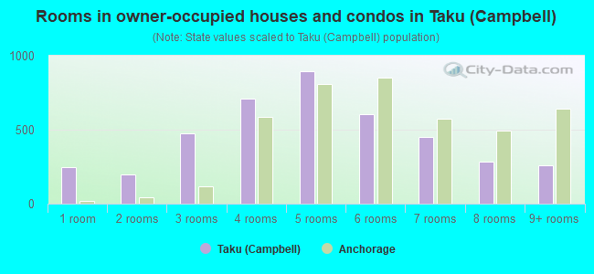
- Rooms in owner-occupied houses and condos in Taku <
> - 2491 room
- 1982 rooms
- 4773 rooms
- 7104 rooms
- 8975 rooms
- 6086 rooms
- 4527 rooms
- 2878 rooms
- 2579+ rooms
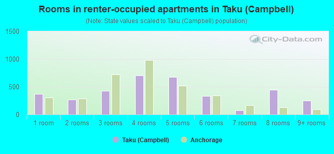
- Rooms in renter-occupied apartments in Taku <
> - 3681 room
- 2672 rooms
- 4293 rooms
- 7074 rooms
- 6795 rooms
- 3366 rooms
- 717 rooms
- 4488 rooms
- 2489+ rooms
Owner-occupied
Renter-occupied
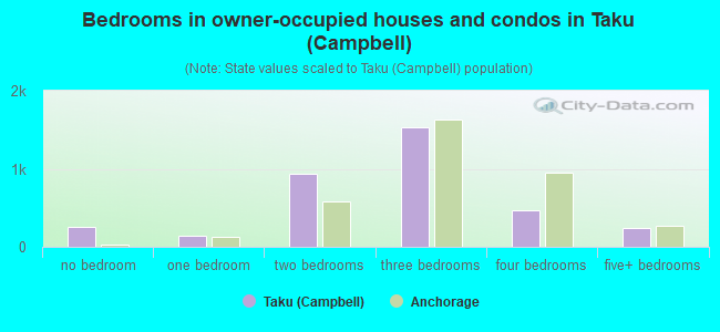
- Bedrooms in owner-occupied houses and condos in Taku <
> - 249no bedroom
- 1481 bedroom
- 9352 bedrooms
- 1,5323 bedrooms
- 4744 bedrooms
- 2445+ bedrooms
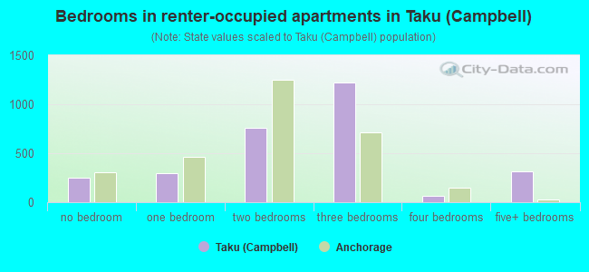
- Bedrooms in renter-occupied apartments in Taku <
> - 250no bedroom
- 2921 bedroom
- 7612 bedrooms
- 1,2243 bedrooms
- 674 bedrooms
- 3175+ bedrooms
Average number of cars or other vehicles available in houses/condos:
Average number of cars or other vehicles available in apartments:
| This neighborhood: | 2.0 |
| Anchorage: | 2.2 |
Average number of cars or other vehicles available in apartments:
| Here: | |
| city: |
Percentage of units with a mortgage:
| Taku (Campbell): | 68.3% |
| Anchorage: | 70.7% |
Average estimated value of detached houses in 2022 (28.3% of all units):
| Taku (Campbell): | $326,775 |
| Anchorage: | $434,732 |
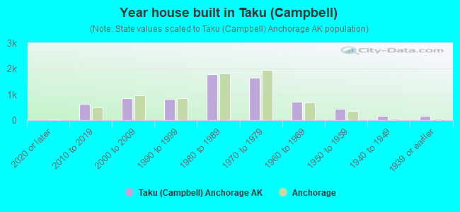
- Year house built in Taku <
> - 02020 or later
- 6272010 to 2019
- 8442000 to 2009
- 8341990 to 1999
- 1,7891980 to 1989
- 1,6481970 to 1979
- 7191960 to 1969
- 4431950 to 1959
- 1741940 to 1949
- 1751939 or earlier
City-data.com crime index for city in 2020 (higher means more crime):
| City: | 559.2 |
| U.S. average: | 219.5 |
Travel time to work (commute)
![Travel time to work (commute)]()
- 272Less than 5 minutes
- 9585 to 9 minutes
- 1,66910 to 14 minutes
- 1,68215 to 19 minutes
- 1,07020 to 24 minutes
- 34825 to 29 minutes
- 23830 to 34 minutes
- 16835 to 39 minutes
- 13840 to 44 minutes
- 1,24745 to 59 minutes
- 12060 to 89 minutes
- 7490 or more minutes

Means of transportation to work
![Means of transportation to work]()
- 69.6%4,921Drove a car alone
- 12.9%909Carpooled
- 14.2%1,002Bus
- 3.8%267Ferryboat
- 3.8%266Taxi
- 0.5%33Motorcycle
- 3.3%236Bicycle
- 5.7%404Walked
- 3.1%216Other means
- 10.7%759Worked at home

Time leaving home to go to work
![Time leaving home to go to work]()
- 19812:00 a.m. to 4:59 a.m.
- 1095:00 a.m. to 5:29 a.m.
- 4475:30 a.m. to 5:59 a.m.
- 2796:00 a.m. to 6:29 a.m.
- 8966:30 a.m. to 6:59 a.m.
- 6457:00 a.m. to 7:29 a.m.
- 1,1537:30 a.m. to 7:59 a.m.
- 7948:00 a.m. to 8:29 a.m.
- 4498:30 a.m. to 8:59 a.m.
- 4829:00 a.m. to 9:59 a.m.
- 27010:00 a.m. to 10:59 a.m.
- 1711:00 a.m. to 11:59 a.m.
- 57312:00 p.m. to 3:59 p.m.
- 4304:00 p.m. to 11:59 p.m.

Occupations of males:
- Percentage of males in management occupations (except farmers):
Here: 5.1% city: 11.1%
- Percentage of males in business and financial operations occupations:
Here: 4.9% city: 4.5%
- Percentage of males in computer and mathematical occupations:
Here: 3.8% city: 3.6%
- Percentage of males in architecture and engineering occupations:
Here: 3.6% city: 4.2%
- Percentage of males in community and social services occupations:
Here: 1.7% city: 1.2%
- Percentage of males in legal occupations:
Here: 2.1% city: 1.3%
- Percentage of males in education, training, and library occupations:
Here: 3.3% city: 3.5%
- Percentage of males in arts, design, entertainment, sports, and media occupations:
Here: 3.0% city: 1.8%
- Percentage of males in healthcare practitioners and technical occupations:
Here: 1.5% city: 3.7%
- Percentage of males in service occupations:
Here: 20.2% city: 17.2%
- Percentage of males in sales and office occupations:
Here: 17.9% city: 14.9%
- Percentage of males in farming, fishing, and forestry occupations:
Here: 1.3% city: 0.4%
- Percentage of males in construction, extraction, and maintenance occupations:
Here: 9.5% city: 7.3%
- Percentage of males in production occupations:
Here: 2.7% city: 3.2%
- Percentage of males in transportation occupations:
Here: 7.0% city: 8.0%
- Percentage of males in material moving occupations:
Here: 7.8% city: 5.7%
Occupations of females:
- Percentage of females in management occupations (except farmers):
Here: 7.7% city: 10.4%
- Percentage of females in business and financial operations occupations:
Here: 13.6% city: 7.1%
- Percentage of females in life, physical, and social science occupations:
Here: 1.6% city: 2.3%
- Percentage of females in education, training, and library occupations:
Here: 5.7% city: 9.0%
- Percentage of females in arts, design, entertainment, sports, and media occupations:
Here: 1.2% city: 2.6%
- Percentage of females in healthcare practitioners and technical occupations:
Here: 6.3% city: 9.6%
- Percentage of females in service occupations:
Here: 17.7% city: 19.2%
- Percentage of females in sales and office occupations:
Here: 38.6% city: 27.3%
- Percentage of females in production occupations:
Here: 1.1% city: 1.5%
- Percentage of females in transportation occupations:
Here: 5.0% city: 1.7%
Percentage of people 16-64 in Armed Forces:
| Taku (Campbell): | 2.4% |
| Anchorage: | 5.7% |
Education in this neighborhood (subdivision or community):
- Percentage of people 3 years and older in K-12 schools:
Taku (Campbell): 32.3% Anchorage: 17.3%
- Percentage of people 3 years and older in undergraduate colleges:
Taku (Campbell): 7.3% Anchorage: 3.9%
- Percentage of people 3 years and older in grad. or professional schools:
Taku (Campbell): 3.7% Anchorage: 1.1%
- Percentage of students K-12 enrolled in private schools:
Taku (Campbell): 23.8% Anchorage: 11.6%
Percentage of population below poverty level:
| Taku (Campbell): | 6.9% |
| Anchorage: | 11.1% |
Median year owner moved in (as recorded in 2022):
| Taku (Campbell): | 2009 |
| Anchorage: | 2013 |
Percentage of married-couple families with both working:
| Taku (Campbell): | 110.2% |
| Anchorage: | 79.2% |
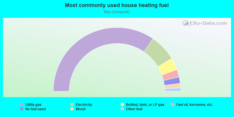
- 69.1%Utility gas
- 13.7%Electricity
- 6.2%Bottled, tank, or LP gas
- 3.8%Fuel oil, kerosene, etc.
- 3.3%No fuel used
- 2.2%Wood
- 1.7%Other fuel
Highways in this neighborhood:
Seward Hwy (New Seward Hwy, State Hwy 1)
Length: 0.25 miles
Direction: N-S
Direction: N-S
Roads and streets:
Arctic Blvd
Length: 2.66 miles
Directions: N-S, SE-NW
Address range: 5300 to 9199
Directions: N-S, SE-NW
Address range: 5300 to 9199
Old Seward Hwy
Length: 2.52 miles
Directions: N-S, SE-NW, SW-NE
Address range: 5344 to 9396
Directions: N-S, SE-NW, SW-NE
Address range: 5344 to 9396
W Dimond Blvd
Length: 1.87 miles
Direction: E-W
Address range: 100 to 1299
Direction: E-W
Address range: 100 to 1299
Rovenna St
Length: 1.85 miles
Directions: E-W, N-S, SE-NW, SW-NE
Address range: 6000 to 8464
Directions: E-W, N-S, SE-NW, SW-NE
Address range: 6000 to 8464
Raspberry Rd
Length: 1.84 miles
Directions: E-W, SW-NE
Address range: 300 to 999
Directions: E-W, SW-NE
Address range: 300 to 999
C St
Length: 1.79 miles
Directions: E-W, N-S
Address range: 5600 to 8399
Directions: E-W, N-S
Address range: 5600 to 8399
E Dowling Rd
Length: 1.73 miles
Direction: E-W
Address range: 100 to 1399
Direction: E-W
Address range: 100 to 1399
E 56th Ave
Length: 1.72 miles
Direction: E-W
Address range: 100 to 1199
Direction: E-W
Address range: 100 to 1199
E 76th Ave
Length: 1.54 miles
Directions: E-W, N-S
Address range: 200 to 1199
Directions: E-W, N-S
Address range: 200 to 1199
W 76th Ave
Length: 1.46 miles
Direction: E-W
Address range: 300 to 1299
Direction: E-W
Address range: 300 to 1299
E Dimond Blvd
Length: 1.44 miles
Direction: E-W
Address range: 200 to 1357
Direction: E-W
Address range: 200 to 1357
W 53rd Ave
Length: 1.26 miles
Directions: E-W, SW-NE
Address range: 100 to 1199
Directions: E-W, SW-NE
Address range: 100 to 1199
W 75th Ave
Length: 1.23 miles
Direction: E-W
Address range: 500 to 1399
Direction: E-W
Address range: 500 to 1399
W Dowling Rd
Length: 1.19 miles
Direction: E-W
Address range: 100 to 1599
Direction: E-W
Address range: 100 to 1599
E 54th Ave
Length: 1.19 miles
Direction: E-W
Address range: 100 to 999
Direction: E-W
Address range: 100 to 999
W 54th Ave
Length: 1.17 miles
Direction: E-W
Address range: 400 to 1200
Direction: E-W
Address range: 400 to 1200
E 72nd Ave
Length: 1.12 miles
Direction: E-W
Address range: 500 to 1399
Direction: E-W
Address range: 500 to 1399
Minnesota Dr
Length: 1.05 miles
Directions: N-S, SE-NW, SW-NE
Address range: 5440 to 5699
Directions: N-S, SE-NW, SW-NE
Address range: 5440 to 5699
Minnesota Byp
Length: 1.05 miles
Directions: N-S, SE-NW
Directions: N-S, SE-NW
W Potter Dr
Length: 1.04 miles
Direction: E-W
Address range: 100 to 799
Direction: E-W
Address range: 100 to 799
Frontage Rd (Homer Dr)
Length: 1.03 miles
Directions: N-S, SW-NE
Address range: 5400 to 8299
Directions: N-S, SW-NE
Address range: 5400 to 8299
King St
Length: 1.03 miles
Directions: N-S, SW-NE
Address range: 7600 to 9199
Directions: N-S, SW-NE
Address range: 7600 to 9199
W 56th Ave
Length: 1.03 miles
Directions: E-W, N-S, SE-NW, SW-NE
Address range: 800 to 1599
Directions: E-W, N-S, SE-NW, SW-NE
Address range: 800 to 1599
W 70th Ave
Length: 1.03 miles
Direction: E-W
Address range: 400 to 1364
Direction: E-W
Address range: 400 to 1364
W 88th Ave
Length: 0.97 miles
Direction: E-W
Address range: 400 to 999
Direction: E-W
Address range: 400 to 999
W 80th Ave
Length: 0.96 miles
Directions: E-W, N-S
Address range: 800 to 1399
Directions: E-W, N-S
Address range: 800 to 1399
W 58th Ave
Length: 0.94 miles
Directions: E-W, SE-NW
Address range: 400 to 999
Directions: E-W, SE-NW
Address range: 400 to 999
E 74th Ave
Length: 0.93 miles
Direction: E-W
Address range: 500 to 1199
Direction: E-W
Address range: 500 to 1199
A St
Length: 0.89 miles
Directions: E-W, N-S, SW-NE
Address range: 5200 to 6499
Directions: E-W, N-S, SW-NE
Address range: 5200 to 6499
E 73rd Ave
Length: 0.88 miles
Directions: E-W, SW-NE
Address range: 401 to 1399
Directions: E-W, SW-NE
Address range: 401 to 1399
E 64th Ave
Length: 0.86 miles
Direction: E-W
Address range: 1300 to 1399
Direction: E-W
Address range: 1300 to 1399
W 72nd Ave
Length: 0.85 miles
Direction: E-W
Address range: 500 to 1099
Direction: E-W
Address range: 500 to 1099
Turquoise St
Length: 0.85 miles
Directions: E-W, N-S, SW-NE
Directions: E-W, N-S, SW-NE
Foxridge Cir
Length: 0.85 miles
Directions: E-W, N-S, SE-NW, SW-NE
Address range: 7201 to 7399
Directions: E-W, N-S, SE-NW, SW-NE
Address range: 7201 to 7399
Cameo St
Length: 0.85 miles
Directions: E-W, N-S, SE-NW, SW-NE
Directions: E-W, N-S, SE-NW, SW-NE
W 74th Ave
Length: 0.77 miles
Direction: E-W
Address range: 500 to 1099
Direction: E-W
Address range: 500 to 1099
W 87th Ave
Length: 0.77 miles
Direction: E-W
Address range: 200 to 799
Direction: E-W
Address range: 200 to 799
Greenwood St
Length: 0.76 miles
Directions: E-W, N-S
Address range: 6000 to 8299
Directions: E-W, N-S
Address range: 6000 to 8299
Crystal Dr
Length: 0.76 miles
Direction: E-W
Direction: E-W
Fairweather Dr (Fairweather Pl)
Length: 0.75 miles
Directions: E-W, N-S, SW-NE
Address range: 6200 to 7099
Directions: E-W, N-S, SW-NE
Address range: 6200 to 7099
Stanley Dr
Length: 0.74 miles
Directions: E-W, N-S, SE-NW
Address range: 6900 to 7999
Directions: E-W, N-S, SE-NW
Address range: 6900 to 7999
Fischer Ave
Length: 0.73 miles
Direction: E-W
Address range: 300 to 799
Direction: E-W
Address range: 300 to 799
Lynwood Dr (Lynnwood Dr)
Length: 0.73 miles
Directions: E-W, N-S, SE-NW, SW-NE
Address range: 300 to 699
Directions: E-W, N-S, SE-NW, SW-NE
Address range: 300 to 699
Garnet Dr
Length: 0.71 miles
Direction: E-W
Direction: E-W
W 92nd Ave
Length: 0.69 miles
Direction: E-W
Address range: 200 to 699
Direction: E-W
Address range: 200 to 699
Mentra St
Length: 0.68 miles
Directions: N-S, SE-NW, SW-NE
Address range: 7600 to 8599
Directions: N-S, SE-NW, SW-NE
Address range: 7600 to 8599
Chad St
Length: 0.65 miles
Directions: E-W, N-S, SE-NW, SW-NE
Address range: 6800 to 7599
Directions: E-W, N-S, SE-NW, SW-NE
Address range: 6800 to 7599
Briarwood St
Length: 0.64 miles
Directions: E-W, N-S, SE-NW
Address range: 7000 to 8399
Directions: E-W, N-S, SE-NW
Address range: 7000 to 8399
E 80th Ave
Length: 0.64 miles
Direction: E-W
Address range: 1000 to 1399
Direction: E-W
Address range: 1000 to 1399
Rosewood St
Length: 0.62 miles
Direction: N-S
Address range: 6000 to 6899
Direction: N-S
Address range: 6000 to 6899
Sylvan Dr
Length: 0.61 miles
Directions: E-W, SW-NE
Directions: E-W, SW-NE
W 77th Ave
Length: 0.58 miles
Direction: E-W
Address range: 900 to 1399
Direction: E-W
Address range: 900 to 1399
E 79th Ave
Length: 0.58 miles
Direction: E-W
Address range: 600 to 999
Direction: E-W
Address range: 600 to 999
Vernon St
Length: 0.57 miles
Directions: E-W, N-S, SW-NE
Address range: 8400 to 9199
Directions: E-W, N-S, SW-NE
Address range: 8400 to 9199
Summerset Dr
Length: 0.57 miles
Directions: E-W, N-S, SE-NW, SW-NE
Address range: 8000 to 8399
Directions: E-W, N-S, SE-NW, SW-NE
Address range: 8000 to 8399
E 92nd Ave
Length: 0.57 miles
Direction: E-W
Address range: 100 to 399
Direction: E-W
Address range: 100 to 399
W 68th Ave (Raspberry Rd)
Length: 0.56 miles
Direction: E-W
Address range: 100 to 299
Direction: E-W
Address range: 100 to 299
B St
Length: 0.56 miles
Directions: E-W, N-S, SE-NW, SW-NE
Address range: 5400 to 6399
Directions: E-W, N-S, SE-NW, SW-NE
Address range: 5400 to 6399
W 64th Ave
Length: 0.54 miles
Direction: E-W
Address range: 200 to 599
Direction: E-W
Address range: 200 to 599
Highlander Dr
Length: 0.54 miles
Directions: E-W, N-S, SE-NW, SW-NE
Address range: 7600 to 7999
Directions: E-W, N-S, SE-NW, SW-NE
Address range: 7600 to 7999
E 81st Ave
Length: 0.54 miles
Direction: E-W
Address range: 600 to 999
Direction: E-W
Address range: 600 to 999
E 69th Ave
Length: 0.53 miles
Direction: E-W
Address range: 1000 to 1121
Direction: E-W
Address range: 1000 to 1121
E 82nd Ave
Length: 0.52 miles
Direction: E-W
Address range: 600 to 999
Direction: E-W
Address range: 600 to 999
E 70th Ave
Length: 0.52 miles
Directions: E-W, N-S
Address range: 1000 to 1399
Directions: E-W, N-S
Address range: 1000 to 1399
E 71st Ave
Length: 0.52 miles
Direction: E-W
Address range: 1000 to 1399
Direction: E-W
Address range: 1000 to 1399
E 78th Ave
Length: 0.51 miles
Direction: E-W
Address range: 600 to 999
Direction: E-W
Address range: 600 to 999
W 71st Ave
Length: 0.51 miles
Direction: E-W
Address range: 700 to 1099
Direction: E-W
Address range: 700 to 1099
E 68th Ave (Raspberry Rd)
Length: 0.51 miles
Direction: E-W
Address range: 1000 to 1399
Direction: E-W
Address range: 1000 to 1399
E 66th Ave
Length: 0.50 miles
Direction: E-W
Address range: 1000 to 1399
Direction: E-W
Address range: 1000 to 1399
Pearl Dr
Length: 0.50 miles
Direction: E-W
Address range: 300 to 799
Direction: E-W
Address range: 300 to 799
Spring St
Length: 0.50 miles
Direction: N-S
Address range: 7800 to 8399
Direction: N-S
Address range: 7800 to 8399
Briar Loop
Length: 0.50 miles
Directions: E-W, SE-NW, SW-NE
Directions: E-W, SE-NW, SW-NE
Hampstead Dr
Length: 0.48 miles
Directions: E-W, N-S, SE-NW, SW-NE
Address range: 6400 to 6699
Directions: E-W, N-S, SE-NW, SW-NE
Address range: 6400 to 6699
Jackson Dr
Length: 0.46 miles
Direction: E-W
Address range: 1100 to 1399
Direction: E-W
Address range: 1100 to 1399
W 82nd Ave
Length: 0.46 miles
Directions: E-W, N-S
Address range: 1100 to 1499
Directions: E-W, N-S
Address range: 1100 to 1499
W 79th Ave
Length: 0.45 miles
Directions: E-W, N-S
Address range: 1100 to 1362
Directions: E-W, N-S
Address range: 1100 to 1362
Schoon St
Length: 0.43 miles
Directions: N-S, SE-NW
Address range: 7700 to 8399
Directions: N-S, SE-NW
Address range: 7700 to 8399
Opal Dr
Length: 0.43 miles
Directions: E-W, SE-NW
Directions: E-W, SE-NW
Nathan Dr
Length: 0.42 miles
Directions: SE-NW, SW-NE
Address range: 500 to 7599
Directions: SE-NW, SW-NE
Address range: 500 to 7599
Merlin Loop
Length: 0.41 miles
Directions: E-W, N-S
Address range: 801 to 837
Directions: E-W, N-S
Address range: 801 to 837
E Potter Dr
Length: 0.40 miles
Directions: E-W, N-S, SE-NW
Address range: 100 to 299
Directions: E-W, N-S, SE-NW
Address range: 100 to 299
W 91st Ave
Length: 0.39 miles
Direction: E-W
Address range: 400 to 699
Direction: E-W
Address range: 400 to 699
W 90th Ave
Length: 0.39 miles
Direction: E-W
Address range: 400 to 676
Direction: E-W
Address range: 400 to 676
W 89th Ave
Length: 0.39 miles
Direction: E-W
Address range: 400 to 677
Direction: E-W
Address range: 400 to 677
W 73rd Ave
Length: 0.39 miles
Direction: E-W
Address range: 800 to 1099
Direction: E-W
Address range: 800 to 1099
Abbott Rd
Length: 0.38 miles
Direction: E-W
Address range: 1000 to 1309
Direction: E-W
Address range: 1000 to 1309
E 75th Ave
Length: 0.38 miles
Direction: E-W
Address range: 600 to 899
Direction: E-W
Address range: 600 to 899
Carnelian St
Length: 0.38 miles
Direction: SE-NW
Direction: SE-NW
Queen Victoria Dr
Length: 0.37 miles
Directions: E-W, N-S, SE-NW, SW-NE
Address range: 8000 to 8199
Directions: E-W, N-S, SE-NW, SW-NE
Address range: 8000 to 8199
Nielson Way
Length: 0.37 miles
Directions: N-S, SE-NW
Address range: 6100 to 6399
Directions: N-S, SE-NW
Address range: 6100 to 6399
Bonanza Ave
Length: 0.37 miles
Direction: E-W
Address range: 500 to 899
Direction: E-W
Address range: 500 to 899
Fairweather Prk Loop
Length: 0.36 miles
Directions: E-W, N-S, SE-NW, SW-NE
Directions: E-W, N-S, SE-NW, SW-NE
Juneau St
Length: 0.34 miles
Direction: N-S
Address range: 6300 to 6499
Direction: N-S
Address range: 6300 to 6499
Cordova St
Length: 0.32 miles
Directions: E-W, N-S, SE-NW, SW-NE
Address range: 5300 to 6199
Directions: E-W, N-S, SE-NW, SW-NE
Address range: 5300 to 6199
Arctic Spur Rd
Length: 0.32 miles
Direction: N-S
Address range: 6300 to 6799
Direction: N-S
Address range: 6300 to 6799
W 86th Ct
Length: 0.32 miles
Direction: E-W
Address range: 522 to 663
Direction: E-W
Address range: 522 to 663
Fairwood Dr
Length: 0.31 miles
Directions: E-W, SW-NE
Address range: 835 to 1034
Directions: E-W, SW-NE
Address range: 835 to 1034
Fairweather Dr (Fairweather Ct)
Length: 0.30 miles
Directions: E-W, N-S, SE-NW, SW-NE
Directions: E-W, N-S, SE-NW, SW-NE
W 57th Ave
Length: 0.29 miles
Direction: E-W
Address range: 800 to 999
Direction: E-W
Address range: 800 to 999
E 53rd Ave
Length: 0.28 miles
Direction: E-W
Address range: 100 to 299
Direction: E-W
Address range: 100 to 299
Foxridge Way
Length: 0.27 miles
Directions: E-W, N-S, SE-NW, SW-NE
Address range: 300 to 7599
Directions: E-W, N-S, SE-NW, SW-NE
Address range: 300 to 7599
Denali St
Length: 0.27 miles
Directions: E-W, N-S, SW-NE
Address range: 5600 to 5999
Directions: E-W, N-S, SW-NE
Address range: 5600 to 5999
A St Lp (Marlaine Dr)
Length: 0.27 miles
Directions: E-W, N-S
Address range: 100 to 199
Directions: E-W, N-S
Address range: 100 to 199
Cope St
Length: 0.26 miles
Directions: N-S, SE-NW
Address range: 5300 to 5799
Directions: N-S, SE-NW
Address range: 5300 to 5799
W 86th Ave
Length: 0.26 miles
Direction: E-W
Address range: 700 to 999
Direction: E-W
Address range: 700 to 999
W 66th Ct
Length: 0.26 miles
Direction: E-W
Address range: 900 to 1099
Direction: E-W
Address range: 900 to 1099
E 58th Ct
Length: 0.26 miles
Direction: E-W
Direction: E-W
Aqua Marine Cir
Length: 0.26 miles
Directions: E-W, N-S
Directions: E-W, N-S
Latouche St
Length: 0.25 miles
Direction: N-S
Direction: N-S
Linda Ln
Length: 0.25 miles
Directions: E-W, N-S, SE-NW
Address range: 7700 to 7999
Directions: E-W, N-S, SE-NW
Address range: 7700 to 7999
Driftwood St
Length: 0.25 miles
Directions: E-W, N-S
Address range: 6600 to 7099
Directions: E-W, N-S
Address range: 6600 to 7099
Branche Dr
Length: 0.25 miles
Directions: E-W, N-S, SE-NW
Address range: 7300 to 7599
Directions: E-W, N-S, SE-NW
Address range: 7300 to 7599
E 87th Ave
Length: 0.25 miles
Direction: E-W
Address range: 200 to 399
Direction: E-W
Address range: 200 to 399
Mackay St
Length: 0.24 miles
Direction: N-S
Address range: 6000 to 6399
Direction: N-S
Address range: 6000 to 6399
W 67th Ave
Length: 0.24 miles
Directions: E-W, N-S
Address range: 400 to 2520
Directions: E-W, N-S
Address range: 400 to 2520
W 78th Ave
Length: 0.23 miles
Direction: E-W
Address range: 1300 to 1399
Direction: E-W
Address range: 1300 to 1399
Barnett Dr
Length: 0.23 miles
Directions: N-S, SE-NW
Address range: 8200 to 8498
Directions: N-S, SE-NW
Address range: 8200 to 8498
Lazuli St
Length: 0.23 miles
Directions: E-W, N-S, SW-NE
Directions: E-W, N-S, SW-NE
Seafood Dr
Length: 0.23 miles
Direction: E-W
Address range: 6600 to 6799
Direction: E-W
Address range: 6600 to 6799
Ressel Ave
Length: 0.23 miles
Direction: E-W
Direction: E-W
Eula St
Length: 0.23 miles
Directions: N-S, SW-NE
Address range: 6100 to 6399
Directions: N-S, SW-NE
Address range: 6100 to 6399
Evander Dr
Length: 0.22 miles
Directions: N-S, SE-NW
Address range: 7633 to 7798
Directions: N-S, SE-NW
Address range: 7633 to 7798
Lumbis Ave
Length: 0.22 miles
Directions: E-W, N-S
Address range: 7600 to 7899
Directions: E-W, N-S
Address range: 7600 to 7899
Cheryl St
Length: 0.22 miles
Directions: N-S, SE-NW
Address range: 6800 to 7099
Directions: N-S, SE-NW
Address range: 6800 to 7099
Arctic Slope Ave (Danner Ave)
Length: 0.22 miles
Direction: E-W
Address range: 200 to 399
Direction: E-W
Address range: 200 to 399
Winners Cir
Length: 0.21 miles
Directions: E-W, N-S
Address range: 1100 to 1243
Directions: E-W, N-S
Address range: 1100 to 1243
Austin Ave
Length: 0.21 miles
Direction: N-S
Address range: 6000 to 6299
Direction: N-S
Address range: 6000 to 6299
E 88th Ave
Length: 0.21 miles
Direction: E-W
Direction: E-W
E 91st Ave
Length: 0.21 miles
Direction: E-W
Direction: E-W
Dimond Blvd
Length: 0.20 miles
Direction: E-W
Direction: E-W
W 71st Ct
Length: 0.20 miles
Direction: E-W
Address range: 1100 to 1184
Direction: E-W
Address range: 1100 to 1184
E 57th Pl
Length: 0.20 miles
Direction: E-W
Address range: 600 to 799
Direction: E-W
Address range: 600 to 799
Huntsman Cir
Length: 0.20 miles
Directions: E-W, N-S, SE-NW, SW-NE
Address range: 7200 to 7387
Directions: E-W, N-S, SE-NW, SW-NE
Address range: 7200 to 7387
King Arthur Cir
Length: 0.19 miles
Direction: E-W
Address range: 600 to 699
Direction: E-W
Address range: 600 to 699
Dorbrandt St
Length: 0.19 miles
Directions: E-W, N-S
Address range: 5300 to 5607
Directions: E-W, N-S
Address range: 5300 to 5607
Joseph St
Length: 0.19 miles
Directions: N-S, SE-NW
Address range: 6801 to 7063
Directions: N-S, SE-NW
Address range: 6801 to 7063
N Star St
Length: 0.18 miles
Direction: N-S
Address range: 5300 to 5550
Direction: N-S
Address range: 5300 to 5550
Dimond D Cir
Length: 0.17 miles
Directions: N-S, SE-NW
Address range: 8400 to 8799
Directions: N-S, SE-NW
Address range: 8400 to 8799
E 55th Ave
Length: 0.17 miles
Direction: E-W
Direction: E-W
Mike St
Length: 0.16 miles
Directions: N-S, SW-NE
Address range: 6100 to 6299
Directions: N-S, SW-NE
Address range: 6100 to 6299
Mentra Cir
Length: 0.16 miles
Directions: E-W, SW-NE
Address range: 8500 to 8599
Directions: E-W, SW-NE
Address range: 8500 to 8599
Glade Pl
Length: 0.16 miles
Directions: N-S, SW-NE
Address range: 7200 to 7444
Directions: N-S, SW-NE
Address range: 7200 to 7444
Ruby St
Length: 0.16 miles
Directions: N-S, SW-NE
Directions: N-S, SW-NE
E 83rd Avenue (Used To Be) (Calista Ct)
Length: 0.16 miles
Direction: E-W
Address range: 300 to 399
Direction: E-W
Address range: 300 to 399
Topaz Pl
Length: 0.16 miles
Direction: N-S
Direction: N-S
Sorcerer Ct
Length: 0.16 miles
Direction: E-W
Address range: 100 to 199
Direction: E-W
Address range: 100 to 199
Snowberry Loop
Length: 0.16 miles
Directions: E-W, N-S, SE-NW, SW-NE
Directions: E-W, N-S, SE-NW, SW-NE
Dallas St
Length: 0.15 miles
Direction: N-S
Direction: N-S
E 57th Ct
Length: 0.15 miles
Direction: E-W
Direction: E-W
E 77th Ave
Length: 0.15 miles
Directions: E-W, SE-NW
Address range: 200 to 399
Directions: E-W, SE-NW
Address range: 200 to 399
Kasolite
Length: 0.15 miles
Direction: SE-NW
Direction: SE-NW
Rappe Ct
Length: 0.15 miles
Directions: E-W, SW-NE
Address range: 700 to 799
Directions: E-W, SW-NE
Address range: 700 to 799
Fairbanks St
Length: 0.15 miles
Direction: N-S
Address range: 5400 to 5599
Direction: N-S
Address range: 5400 to 5599
Gram Cir
Length: 0.15 miles
Directions: E-W, N-S
Address range: 1300 to 1399
Directions: E-W, N-S
Address range: 1300 to 1399
Kirsten Cir
Length: 0.14 miles
Direction: E-W
Address range: 1300 to 1399
Direction: E-W
Address range: 1300 to 1399
W 72nd Cir
Length: 0.14 miles
Direction: E-W
Address range: 1300 to 1399
Direction: E-W
Address range: 1300 to 1399
W 73rd Cir
Length: 0.14 miles
Direction: E-W
Address range: 1300 to 1399
Direction: E-W
Address range: 1300 to 1399
Heidi Cir
Length: 0.14 miles
Direction: E-W
Address range: 1300 to 1399
Direction: E-W
Address range: 1300 to 1399
Hart St
Length: 0.14 miles
Direction: N-S
Address range: 7000 to 7299
Direction: N-S
Address range: 7000 to 7299
Fairwood Cir
Length: 0.14 miles
Directions: E-W, N-S, SE-NW
Address range: 8000 to 8198
Directions: E-W, N-S, SE-NW
Address range: 8000 to 8198
E 75th Ct
Length: 0.14 miles
Directions: E-W, N-S
Address range: 600 to 7599
Directions: E-W, N-S
Address range: 600 to 7599
Bridgestone Ct
Length: 0.13 miles
Direction: E-W
Direction: E-W
Ange Dr (Ange St)
Length: 0.13 miles
Directions: E-W, N-S, SE-NW
Address range: 8500 to 8799
Directions: E-W, N-S, SE-NW
Address range: 8500 to 8799
Franklin Dr
Length: 0.13 miles
Direction: SW-NE
Address range: 5914 to 5998
Direction: SW-NE
Address range: 5914 to 5998
Blackburn Ct
Length: 0.13 miles
Direction: E-W
Direction: E-W
Ingra St
Length: 0.13 miles
Direction: N-S
Direction: N-S
Laviento Dr
Length: 0.13 miles
Directions: E-W, N-S, SE-NW
Address range: 8400 to 8647
Directions: E-W, N-S, SE-NW
Address range: 8400 to 8647
Bradley Cir
Length: 0.13 miles
Directions: E-W, SE-NW
Address range: 700 to 899
Directions: E-W, SE-NW
Address range: 700 to 899
Stormy Pl
Length: 0.12 miles
Direction: N-S
Address range: 8200 to 8399
Direction: N-S
Address range: 8200 to 8399
Rainy Pl
Length: 0.12 miles
Direction: N-S
Address range: 8200 to 8399
Direction: N-S
Address range: 8200 to 8399
Michelin Pl
Length: 0.12 miles
Direction: N-S
Address range: 7200 to 7399
Direction: N-S
Address range: 7200 to 7399
Silverado Way
Length: 0.12 miles
Direction: N-S
Address range: 5600 to 5899
Direction: N-S
Address range: 5600 to 5899
76th Ct
Length: 0.12 miles
Directions: E-W, N-S, SE-NW
Directions: E-W, N-S, SE-NW
Zircon Cir
Length: 0.12 miles
Direction: SW-NE
Direction: SW-NE
Atlantis Ave
Length: 0.12 miles
Direction: E-W
Address range: 400 to 499
Direction: E-W
Address range: 400 to 499
Frank St
Length: 0.12 miles
Directions: E-W, N-S
Address range: 8100 to 8325
Directions: E-W, N-S
Address range: 8100 to 8325
Silverberry Loop
Length: 0.11 miles
Directions: E-W, N-S, SE-NW
Directions: E-W, N-S, SE-NW
Papago Pl
Length: 0.11 miles
Direction: N-S
Address range: 7200 to 7399
Direction: N-S
Address range: 7200 to 7399
Interstate St
Length: 0.11 miles
Direction: N-S
Direction: N-S
Woodgreen Cir
Length: 0.10 miles
Directions: E-W, N-S, SE-NW
Address range: 8000 to 8176
Directions: E-W, N-S, SE-NW
Address range: 8000 to 8176
Midland Pl
Length: 0.10 miles
Direction: N-S
Address range: 8545 to 8799
Direction: N-S
Address range: 8545 to 8799
W 68th Ct
Length: 0.10 miles
Direction: E-W
Address range: 1100 to 1199
Direction: E-W
Address range: 1100 to 1199
el Paso Pl
Length: 0.10 miles
Direction: N-S
Address range: 8600 to 8799
Direction: N-S
Address range: 8600 to 8799
Gem Pl
Length: 0.10 miles
Direction: E-W
Direction: E-W
Spring Pl
Length: 0.10 miles
Directions: N-S, SE-NW
Address range: 7200 to 7399
Directions: N-S, SE-NW
Address range: 7200 to 7399
W 59th Ave
Length: 0.10 miles
Direction: E-W
Address range: 700 to 799
Direction: E-W
Address range: 700 to 799
Highlander Cir
Length: 0.10 miles
Directions: E-W, SW-NE
Address range: 600 to 699
Directions: E-W, SW-NE
Address range: 600 to 699
Eielson St
Length: 0.10 miles
Direction: N-S
Address range: 5300 to 5499
Direction: N-S
Address range: 5300 to 5499
Jesters Cir (Jesters Pl)
Length: 0.09 miles
Directions: E-W, N-S
Address range: 8000 to 8199
Directions: E-W, N-S
Address range: 8000 to 8199
Papa Cir
Length: 0.09 miles
Direction: N-S
Address range: 7400 to 7599
Direction: N-S
Address range: 7400 to 7599
Margaret Cir
Length: 0.09 miles
Direction: N-S
Address range: 7400 to 7599
Direction: N-S
Address range: 7400 to 7599
W 81st Ave
Length: 0.09 miles
Direction: E-W
Address range: 700 to 799
Direction: E-W
Address range: 700 to 799
Wade Cir
Length: 0.09 miles
Direction: N-S
Address range: 7400 to 7599
Direction: N-S
Address range: 7400 to 7599
Lars Cir
Length: 0.08 miles
Directions: E-W, N-S, SE-NW
Address range: 7700 to 7799
Directions: E-W, N-S, SE-NW
Address range: 7700 to 7799
Raymar Cir
Length: 0.08 miles
Directions: N-S, SW-NE
Address range: 7800 to 7899
Directions: N-S, SW-NE
Address range: 7800 to 7899
Laona Cir
Length: 0.07 miles
Directions: E-W, N-S
Address range: 1300 to 1399
Directions: E-W, N-S
Address range: 1300 to 1399
Mentra Ct
Length: 0.07 miles
Directions: E-W, SW-NE
Address range: 8400 to 8500
Directions: E-W, SW-NE
Address range: 8400 to 8500
Interstate Cir
Length: 0.07 miles
Direction: N-S
Address range: 6400 to 6599
Direction: N-S
Address range: 6400 to 6599
Riverstone Way
Length: 0.06 miles
Direction: E-W
Direction: E-W
Wes Way
Length: 0.06 miles
Direction: N-S
Address range: 6600 to 6799
Direction: N-S
Address range: 6600 to 6799
Four Winds Dr
Length: 0.06 miles
Directions: N-S, SE-NW
Address range: 5500 to 5599
Directions: N-S, SE-NW
Address range: 5500 to 5599
Center Ct
Length: 0.06 miles
Direction: E-W
Address range: 200 to 299
Direction: E-W
Address range: 200 to 299
Laona Dr
Length: 0.05 miles
Direction: N-S
Address range: 1226 to 1399
Direction: N-S
Address range: 1226 to 1399
Temple Cir
Length: 0.05 miles
Direction: E-W
Address range: 800 to 899
Direction: E-W
Address range: 800 to 899
Scotsman Dr
Length: 0.05 miles
Direction: N-S
Address range: 7600 to 7699
Direction: N-S
Address range: 7600 to 7699
55th Ave
Length: 0.05 miles
Direction: E-W
Address range: 100 to 199
Direction: E-W
Address range: 100 to 199
Hampstead Ct
Length: 0.05 miles
Directions: E-W, SW-NE
Directions: E-W, SW-NE
Nathan Cir
Length: 0.05 miles
Directions: E-W, SE-NW
Address range: 400 to 627
Directions: E-W, SE-NW
Address range: 400 to 627
Libra Pl
Length: 0.04 miles
Directions: E-W, N-S
Address range: 6300 to 6313
Directions: E-W, N-S
Address range: 6300 to 6313
Jayme Ct
Length: 0.04 miles
Direction: SW-NE
Address range: 900 to 7899
Direction: SW-NE
Address range: 900 to 7899
Star Cir
Length: 0.04 miles
Directions: N-S, SE-NW
Directions: N-S, SE-NW
Janite Cir
Length: 0.04 miles
Direction: N-S
Direction: N-S
Copperbush Ct
Length: 0.03 miles
Direction: SW-NE
Address range: 500 to 717
Direction: SW-NE
Address range: 500 to 717
Wildrose Ct
Length: 0.02 miles
Direction: SW-NE
Address range: 800 to 1116
Direction: SW-NE
Address range: 800 to 1116
Railroad features:
The Alaska RR
Length: 3.94 miles
Directions: N-S, SE-NW
Directions: N-S, SE-NW
Other features:
Campbell Creek Greenbelt Park
Length: 3.56 miles
Directions: E-W, N-S, SE-NW, SW-NE
Directions: E-W, N-S, SE-NW, SW-NE
Campbell Crk
Length: 2.97 miles
Directions: E-W, N-S, SE-NW, SW-NE
Directions: E-W, N-S, SE-NW, SW-NE
Little Campbell Crk
Length: 1.53 miles
Directions: E-W, N-S, SE-NW, SW-NE
Directions: E-W, N-S, SE-NW, SW-NE
Stream
Length: 0.84 miles
Directions: E-W, SE-NW
Directions: E-W, SE-NW
Other features:
North Fork Little Campbell Crk
Length: 0.11 miles
Directions: E-W, SW-NE
Directions: E-W, SW-NE