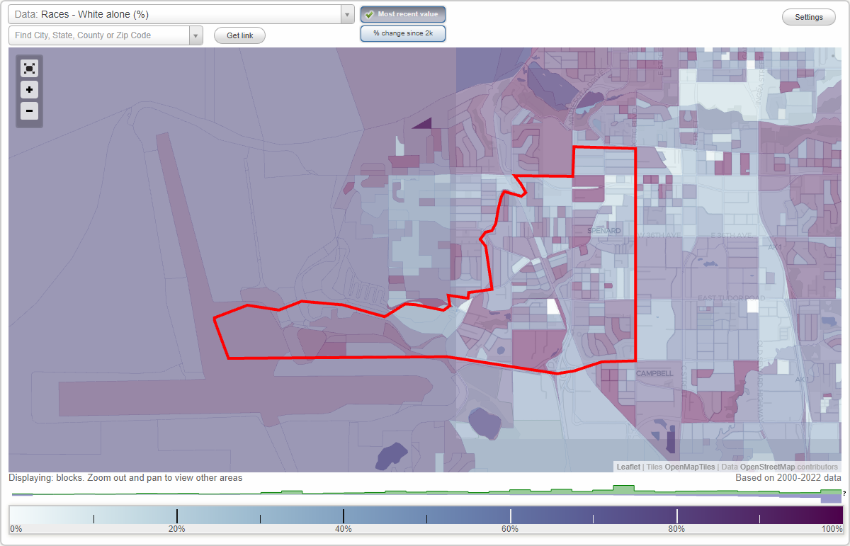
Spenard neighborhood in Anchorage, Alaska (AK), 99517, 99502, 99503 detailed profile
Settings
X

Business Search - 14 Million verified businesses
Area: 2.800 square miles
Population: 11,243
Population density:
| Spenard: | 4,016 people per square mile |
| Anchorage: | 169 people per square mile |

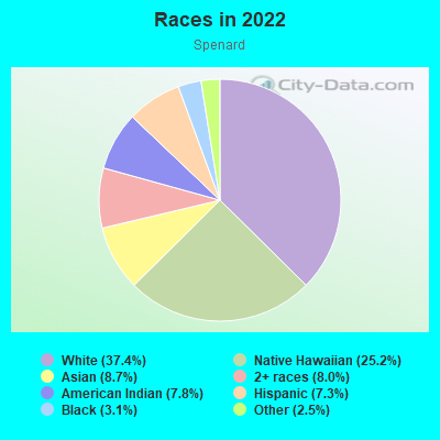
- 5,72237.4%White
- 3,85025.2%Native Hawaiian and Other
Pacific Islander - 1,3288.7%Asian
- 1,2178.0%Two or more races
- 1,1917.8%American Indian
- 1,1187.3%Hispanic or Latino
- 4793.1%Black
- 3802.5%Some other race
Distribution of median household income
![Distribution of median household income]()
- 354Less than $10,000
- 1,087$10,000 to $19,999
- 627$20,000 to $29,999
- 739$30,000 to $39,999
- 708$40,000 to $49,999
- 364$50,000 to $59,999
- 523$60,000 to $74,999
- 886$75,000 to $99,999
- 561$100,000 to $124,999
- 725$125,000 to $149,999
- 326$150,000 to $199,999
- 352$200,000 or more

Distribution of owner-occupied house/condo value
![Distribution of owner-occupied house/condo value]()
- 2,009Less than $50,000
- 694$50,000 to $99,999
- 1,009$100,000 to $149,999
- 333$150,000 to $199,999
- 689$200,000 to $249,999
- 602$250,000 to $299,999
- 550$300,000 to $399,999
- 246$400,000 to $499,999
- 194$500,000 to $749,999
- 3$750,000 to $999,999
- 12$1,000,000 or more

Distribution of rent paid by renters
![Distribution of rent paid by renters]()
- 281Less than $100
- 277$100 to $199
- 181$300 to $399
- 1,080$400 to $499
- 612$500 to $599
- 180$600 to $699
- 418$700 to $799
- 502$800 to $899
- 999$900 to $999
- 1,618$1,000 to $1,249
- 618$1,250 to $1,499
- 476$1,500 to $1,999
- 528$2,000 or more

| Males: | 5,897 |
| Females: | 5,345 |
Males:
| This neighborhood: | 36.7 years |
| Whole city: | 34.8 years |
| This neighborhood: | 38.7 years |
| Whole city: | 36.0 years |
Average household size:
| Spenard: | 4.8 people |
| Anchorage: | 2.5 people |
Percentage of family households:
| Spenard: | 42.9% |
| Anchorage: | 49.0% |
| Here: | 34.2% |
| Anchorage: | 45.5% |
Percentage of married-couple families with children (among all households):
| Spenard: | 28.7% |
| Anchorage: | 23.6% |
Percentage of single-mother households (among all households):
| Spenard: | 11.5% |
| Anchorage: | 10.8% |
Percentage of never married males 15 years old and over:
Percentage of never married females 15 years old and over:
| Spenard: | 21.9% |
| Anchorage: | 20.0% |
Percentage of never married females 15 years old and over:
| Spenard: | 15.0% |
| city: | 15.3% |
Percentage of people that speak English not well or not at all:
| Spenard: | 3.5% |
| Anchorage: | 2.1% |
Percentage of people born in this state:
Percentage of people born in another U.S. state:
Percentage of native residents but born outside the U.S.:
Percentage of foreign born residents:
| Here: | 43.5% |
| Anchorage: | 40.3% |
Percentage of people born in another U.S. state:
| Spenard: | 39.2% |
| Anchorage: | 46.0% |
Percentage of native residents but born outside the U.S.:
| Here: | 2.7% |
| city: | 3.4% |
Percentage of foreign born residents:
| Here: | 14.6% |
| Anchorage: | 10.4% |
Owner-occupied
Renter-occupied

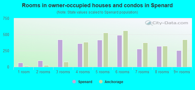
- Rooms in owner-occupied houses and condos in Spenard
- 651 room
- 992 rooms
- 4233 rooms
- 3614 rooms
- 4155 rooms
- 4936 rooms
- 2777 rooms
- 3198 rooms
- 2539+ rooms
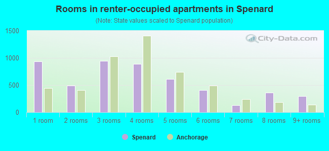
- Rooms in renter-occupied apartments in Spenard
- 9381 room
- 4952 rooms
- 9403 rooms
- 8934 rooms
- 6115 rooms
- 4096 rooms
- 1307 rooms
- 3608 rooms
- 2939+ rooms
Owner-occupied
Renter-occupied
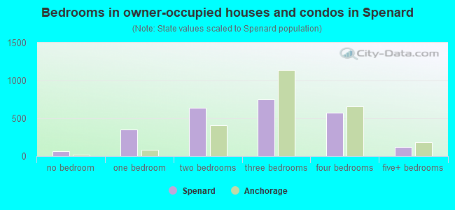
- Bedrooms in owner-occupied houses and condos in Spenard
- 65no bedroom
- 3561 bedroom
- 6402 bedrooms
- 7463 bedrooms
- 5704 bedrooms
- 1225+ bedrooms
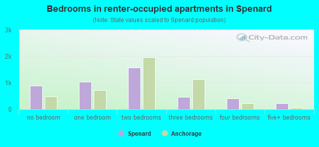
- Bedrooms in renter-occupied apartments in Spenard
- 890no bedroom
- 1,0371 bedroom
- 1,5662 bedrooms
- 4603 bedrooms
- 4044 bedrooms
- 2205+ bedrooms
Average number of cars or other vehicles available in houses/condos:
Average number of cars or other vehicles available in apartments:
| This neighborhood: | 3.0 |
| Anchorage: | 2.2 |
Average number of cars or other vehicles available in apartments:
| Here: | 1.8 |
| city: | 1.3 |
Percentage of units with a mortgage:
| Spenard: | 60.5% |
| Anchorage: | 70.7% |
Average estimated value of detached houses in 2022 (37.2% of all units):
| Spenard: | $377,232 |
| Anchorage: | $434,732 |
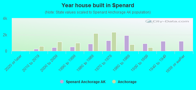
- Year house built in Spenard
- 02020 or later
- 2512010 to 2019
- 4252000 to 2009
- 5321990 to 1999
- 8761980 to 1989
- 1,2731970 to 1979
- 1,8971960 to 1969
- 9291950 to 1959
- 1,2031940 to 1949
- 1,1991939 or earlier
City-data.com crime index for city in 2020 (higher means more crime):
| City: | 559.2 |
| U.S. average: | 219.5 |
Travel time to work (commute)
![Travel time to work (commute)]()
- 110Less than 5 minutes
- 9325 to 9 minutes
- 1,38410 to 14 minutes
- 1,29415 to 19 minutes
- 84420 to 24 minutes
- 27925 to 29 minutes
- 18630 to 34 minutes
- 2835 to 39 minutes
- 1440 to 44 minutes
- 145 to 59 minutes
- 8560 to 89 minutes
- 5490 or more minutes

Means of transportation to work
![Means of transportation to work]()
- 70.1%4,126Drove a car alone
- 12.8%753Carpooled
- 10.8%636Bus
- 2.8%164Ferryboat
- 16.9%994Taxi
- 2.6%154Motorcycle
- 5.0%293Bicycle
- 3.2%187Walked
- 2.6%156Other means
- 10.2%601Worked at home

Time leaving home to go to work
![Time leaving home to go to work]()
- 29812:00 a.m. to 4:59 a.m.
- 1775:00 a.m. to 5:29 a.m.
- 1205:30 a.m. to 5:59 a.m.
- 2306:00 a.m. to 6:29 a.m.
- 3136:30 a.m. to 6:59 a.m.
- 4087:00 a.m. to 7:29 a.m.
- 7597:30 a.m. to 7:59 a.m.
- 5018:00 a.m. to 8:29 a.m.
- 2358:30 a.m. to 8:59 a.m.
- 4239:00 a.m. to 9:59 a.m.
- 23910:00 a.m. to 10:59 a.m.
- 7111:00 a.m. to 11:59 a.m.
- 60512:00 p.m. to 3:59 p.m.
- 7894:00 p.m. to 11:59 p.m.

Occupations of males:
- Percentage of males in management occupations (except farmers):
Here: 8.6% city: 11.1%
- Percentage of males in business and financial operations occupations:
Here: 4.1% city: 4.5%
- Percentage of males in computer and mathematical occupations:
Here: 5.1% city: 3.6%
- Percentage of males in life, physical, and social science occupations:
Here: 2.3% city: 1.6%
- Percentage of males in community and social services occupations:
Here: 1.5% city: 1.2%
- Percentage of males in education, training, and library occupations:
Here: 8.1% city: 3.5%
- Percentage of males in arts, design, entertainment, sports, and media occupations:
Here: 1.5% city: 1.8%
- Percentage of males in healthcare practitioners and technical occupations:
Here: 1.1% city: 3.7%
- Percentage of males in service occupations:
Here: 17.1% city: 17.2%
- Percentage of males in sales and office occupations:
Here: 17.1% city: 14.9%
- Percentage of males in construction, extraction, and maintenance occupations:
Here: 3.3% city: 7.3%
- Percentage of males in production occupations:
Here: 3.3% city: 3.2%
- Percentage of males in transportation occupations:
Here: 11.4% city: 8.0%
- Percentage of males in material moving occupations:
Here: 7.6% city: 5.7%
Occupations of females:
- Percentage of females in management occupations (except farmers):
Here: 8.9% city: 10.4%
- Percentage of females in business and financial operations occupations:
Here: 4.6% city: 7.1%
- Percentage of females in life, physical, and social science occupations:
Here: 4.3% city: 2.3%
- Percentage of females in community and social services occupations:
Here: 2.7% city: 2.6%
- Percentage of females in legal occupations:
Here: 1.3% city: 1.6%
- Percentage of females in education, training, and library occupations:
Here: 6.0% city: 9.0%
- Percentage of females in healthcare practitioners and technical occupations:
Here: 11.5% city: 9.6%
- Percentage of females in service occupations:
Here: 22.7% city: 19.2%
- Percentage of females in sales and office occupations:
Here: 29.6% city: 27.3%
- Percentage of females in production occupations:
Here: 4.1% city: 1.5%
- Percentage of females in transportation occupations:
Here: 2.7% city: 1.7%
- Percentage of females in material moving occupations:
Here: 1.5% city: 1.7%
Percentage of people 16-64 in Armed Forces:
| Spenard: | 1.7% |
| Anchorage: | 5.7% |
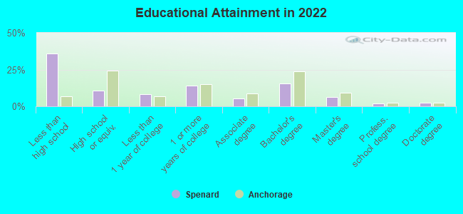
Education in this neighborhood (subdivision or community):
- Percentage of people 3 years and older in K-12 schools:
Spenard: 19.5% Anchorage: 17.3%
- Percentage of people 3 years and older in undergraduate colleges:
Spenard: 7.2% Anchorage: 3.9%
- Percentage of people 3 years and older in grad. or professional schools:
Spenard: 1.8% Anchorage: 1.1%
- Percentage of students K-12 enrolled in private schools:
Spenard: 35.2% Anchorage: 11.6%
Percentage of population below poverty level:
| Spenard: | 16.2% |
| Anchorage: | 11.1% |
Percentage of married-couple families with both working:
| Spenard: | 83.1% |
| Anchorage: | 79.2% |
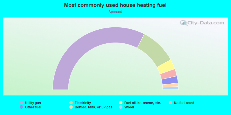
- 65.2%Utility gas
- 19.0%Electricity
- 5.1%Fuel oil, kerosene, etc.
- 3.8%No fuel used
- 3.6%Other fuel
- 1.8%Bottled, tank, or LP gas
- 1.6%Wood
Roads and streets:
W International Airport Rd
Length: 4.00 miles
Directions: E-W, N-S, SE-NW, SW-NE
Address range: 800 to 5299
Directions: E-W, N-S, SE-NW, SW-NE
Address range: 800 to 5299
Jewel Lake Rd (Spenard Rd)
Length: 3.52 miles
Directions: E-W, N-S, SW-NE
Address range: 2608 to 5087
Directions: E-W, N-S, SW-NE
Address range: 2608 to 5087
W 36th Ave
Length: 2.25 miles
Directions: E-W, N-S, SE-NW, SW-NE
Address range: 800 to 2599
Directions: E-W, N-S, SE-NW, SW-NE
Address range: 800 to 2599
W 32nd Ave
Length: 2.01 miles
Directions: E-W, SE-NW, SW-NE
Address range: 900 to 2499
Directions: E-W, SE-NW, SW-NE
Address range: 900 to 2499
Arctic Blvd
Length: 1.67 miles
Direction: N-S
Address range: 2500 to 5199
Direction: N-S
Address range: 2500 to 5199
W Tudor Rd
Length: 1.66 miles
Direction: E-W
Address range: 800 to 2399
Direction: E-W
Address range: 800 to 2399
W Benson Blvd
Length: 1.63 miles
Direction: E-W
Address range: 1100 to 2098
Direction: E-W
Address range: 1100 to 2098
W 34th Ave
Length: 1.53 miles
Direction: E-W
Address range: 928 to 2599
Direction: E-W
Address range: 928 to 2599
Old International Airport Rd
Length: 1.49 miles
Direction: E-W
Direction: E-W
W 47th Ave
Length: 1.42 miles
Direction: E-W
Address range: 1200 to 2499
Direction: E-W
Address range: 1200 to 2499
W 50th Ave
Length: 1.39 miles
Directions: E-W, N-S, SE-NW, SW-NE
Address range: 3800 to 4899
Directions: E-W, N-S, SE-NW, SW-NE
Address range: 3800 to 4899
Aviation Ave (Aviation Dr)
Length: 1.36 miles
Directions: E-W, SE-NW, SW-NE
Directions: E-W, SE-NW, SW-NE
W 29th Ave
Length: 1.33 miles
Directions: E-W, SE-NW
Address range: 870 to 2208
Directions: E-W, SE-NW
Address range: 870 to 2208
Lois Dr
Length: 1.32 miles
Directions: N-S, SE-NW, SW-NE
Address range: 2890 to 4699
Directions: N-S, SE-NW, SW-NE
Address range: 2890 to 4699
W 46th Ave
Length: 1.29 miles
Direction: E-W
Address range: 1200 to 2399
Direction: E-W
Address range: 1200 to 2399
Minnesota Dr
Length: 1.23 miles
Directions: N-S, SW-NE
Address range: 2966 to 4699
Directions: N-S, SW-NE
Address range: 2966 to 4699
W 33rd Ave
Length: 1.14 miles
Direction: E-W
Address range: 1100 to 1999
Direction: E-W
Address range: 1100 to 1999
N Frontage Rd
Length: 1.10 miles
Direction: E-W
Address range: 2801 to 2899
Direction: E-W
Address range: 2801 to 2899
W 45th Ave
Length: 1.07 miles
Direction: E-W
Address range: 1200 to 2399
Direction: E-W
Address range: 1200 to 2399
Northwood Dr
Length: 0.98 miles
Directions: N-S, SE-NW, SW-NE
Address range: 3801 to 5291
Directions: N-S, SE-NW, SW-NE
Address range: 3801 to 5291
Jefferson Ave
Length: 0.97 miles
Directions: E-W, SW-NE
Address range: 1600 to 2399
Directions: E-W, SW-NE
Address range: 1600 to 2399
W 48th Ave
Length: 0.90 miles
Direction: E-W
Address range: 1800 to 2399
Direction: E-W
Address range: 1800 to 2399
Roosevelt Dr
Length: 0.89 miles
Directions: E-W, N-S, SW-NE
Address range: 1600 to 2399
Directions: E-W, N-S, SW-NE
Address range: 1600 to 2399
Aspen Dr
Length: 0.86 miles
Direction: E-W
Address range: 2400 to 2999
Direction: E-W
Address range: 2400 to 2999
W 26th Ave
Length: 0.84 miles
Direction: E-W
Address range: 800 to 1381
Direction: E-W
Address range: 800 to 1381
W 31st Ave
Length: 0.81 miles
Direction: E-W
Address range: 1200 to 2299
Direction: E-W
Address range: 1200 to 2299
Chugach Way
Length: 0.80 miles
Direction: E-W
Address range: 800 to 1399
Direction: E-W
Address range: 800 to 1399
McRae Rd (Mc Rae Rd)
Length: 0.79 miles
Directions: E-W, SE-NW
Address range: 2200 to 2682
Directions: E-W, SE-NW
Address range: 2200 to 2682
W 40th Ave
Length: 0.75 miles
Direction: E-W
Address range: 900 to 1599
Direction: E-W
Address range: 900 to 1599
Oxford Dr
Length: 0.71 miles
Directions: E-W, N-S, SE-NW, SW-NE
Address range: 1200 to 1799
Directions: E-W, N-S, SE-NW, SW-NE
Address range: 1200 to 1799
Cope St
Length: 0.68 miles
Direction: N-S
Address range: 2800 to 4399
Direction: N-S
Address range: 2800 to 4399
Mc Kinley Ave
Length: 0.67 miles
Directions: E-W, SE-NW
Address range: 1700 to 2399
Directions: E-W, SE-NW
Address range: 1700 to 2399
Greenland Dr
Length: 0.65 miles
Directions: N-S, SE-NW
Address range: 3200 to 4399
Directions: N-S, SE-NW
Address range: 3200 to 4399
W 30th Ave
Length: 0.65 miles
Directions: E-W, SE-NW
Address range: 800 to 1599
Directions: E-W, SE-NW
Address range: 800 to 1599
Postmark Dr
Length: 0.65 miles
Directions: E-W, N-S, SE-NW
Address range: 4598 to 4899
Directions: E-W, N-S, SE-NW
Address range: 4598 to 4899
Harding Dr
Length: 0.63 miles
Direction: SE-NW
Address range: 1700 to 4799
Direction: SE-NW
Address range: 1700 to 4799
Lincoln Ave
Length: 0.60 miles
Directions: E-W, N-S
Address range: 2100 to 2399
Directions: E-W, N-S
Address range: 2100 to 2399
Southampton Dr
Length: 0.60 miles
Directions: E-W, N-S, SE-NW
Address range: 900 to 5099
Directions: E-W, N-S, SE-NW
Address range: 900 to 5099
Cambridge Way
Length: 0.58 miles
Directions: N-S, SE-NW, SW-NE
Address range: 4400 to 5199
Directions: N-S, SE-NW, SW-NE
Address range: 4400 to 5199
Cleveland Ave
Length: 0.58 miles
Directions: E-W, SW-NE
Address range: 1700 to 2299
Directions: E-W, SW-NE
Address range: 1700 to 2299
W 41st Ave
Length: 0.55 miles
Direction: E-W
Address range: 1200 to 1599
Direction: E-W
Address range: 1200 to 1599
W 43rd Ave
Length: 0.54 miles
Direction: E-W
Address range: 1200 to 1599
Direction: E-W
Address range: 1200 to 1599
W 42nd Ave
Length: 0.54 miles
Direction: E-W
Address range: 1200 to 1599
Direction: E-W
Address range: 1200 to 1599
N Star St
Length: 0.54 miles
Direction: N-S
Address range: 2800 to 4399
Direction: N-S
Address range: 2800 to 4399
Minnesota Byp
Length: 0.53 miles
Directions: N-S, SE-NW, SW-NE
Address range: 4700 to 5001
Directions: N-S, SE-NW, SW-NE
Address range: 4700 to 5001
W 27th Ave
Length: 0.52 miles
Directions: E-W, SE-NW
Address range: 800 to 1199
Directions: E-W, SE-NW
Address range: 800 to 1199
W Northern Lights Blvd
Length: 0.52 miles
Direction: E-W
Address range: 800 to 1199
Direction: E-W
Address range: 800 to 1199
W 25th Ave
Length: 0.52 miles
Direction: E-W
Address range: 800 to 1199
Direction: E-W
Address range: 800 to 1199
W 29th Pl
Length: 0.52 miles
Direction: E-W
Address range: 800 to 1199
Direction: E-W
Address range: 800 to 1199
Aircraft Dr
Length: 0.51 miles
Directions: E-W, SE-NW
Address range: 4526 to 4899
Directions: E-W, SE-NW
Address range: 4526 to 4899
Van Buren St
Length: 0.51 miles
Directions: N-S, SW-NE
Address range: 4400 to 5099
Directions: N-S, SW-NE
Address range: 4400 to 5099
Garfield St
Length: 0.46 miles
Direction: N-S
Address range: 4000 to 4799
Direction: N-S
Address range: 4000 to 4799
Melvin Ave
Length: 0.44 miles
Directions: E-W, SW-NE
Address range: 2500 to 4799
Directions: E-W, SW-NE
Address range: 2500 to 4799
Wyoming Dr
Length: 0.44 miles
Directions: N-S, SE-NW
Address range: 3200 to 4099
Directions: N-S, SE-NW
Address range: 3200 to 4099
Westbury Dr
Length: 0.43 miles
Direction: E-W
Address range: 850 to 1199
Direction: E-W
Address range: 850 to 1199
Tower Rd
Length: 0.43 miles
Directions: E-W, SW-NE
Directions: E-W, SW-NE
Malibu Rd
Length: 0.41 miles
Directions: N-S, SW-NE
Address range: 4700 to 4899
Directions: N-S, SW-NE
Address range: 4700 to 4899
Klamath Dr
Length: 0.41 miles
Directions: E-W, SE-NW
Address range: 2600 to 2999
Directions: E-W, SE-NW
Address range: 2600 to 2999
Arkansas Dr
Length: 0.41 miles
Direction: N-S
Address range: 3600 to 4199
Direction: N-S
Address range: 3600 to 4199
Wilshire Ave
Length: 0.40 miles
Direction: E-W
Address range: 994 to 1299
Direction: E-W
Address range: 994 to 1299
Wilson St
Length: 0.40 miles
Direction: N-S
Address range: 3700 to 4399
Direction: N-S
Address range: 3700 to 4399
Iowa Dr
Length: 0.39 miles
Directions: N-S, SE-NW, SW-NE
Address range: 3700 to 4399
Directions: N-S, SE-NW, SW-NE
Address range: 3700 to 4399
Oregon Dr
Length: 0.38 miles
Direction: N-S
Address range: 3200 to 3799
Direction: N-S
Address range: 3200 to 3799
Lancaster Dr
Length: 0.38 miles
Direction: E-W
Address range: 800 to 1099
Direction: E-W
Address range: 800 to 1099
W 35th Ave
Length: 0.35 miles
Direction: E-W
Address range: 1200 to 1599
Direction: E-W
Address range: 1200 to 1599
Iris Dr
Length: 0.35 miles
Direction: E-W
Address range: 2800 to 2999
Direction: E-W
Address range: 2800 to 2999
Valleywood Dr
Length: 0.34 miles
Directions: E-W, SE-NW
Address range: 2700 to 2999
Directions: E-W, SE-NW
Address range: 2700 to 2999
Barbara Dr
Length: 0.34 miles
Direction: N-S
Address range: 3700 to 4199
Direction: N-S
Address range: 3700 to 4199
Willow St
Length: 0.34 miles
Direction: N-S
Address range: 2900 to 3599
Direction: N-S
Address range: 2900 to 3599
Iowa St
Length: 0.31 miles
Directions: E-W, N-S
Address range: 3200 to 3599
Directions: E-W, N-S
Address range: 3200 to 3599
Shakespeare Cir
Length: 0.29 miles
Directions: E-W, N-S
Address range: 800 to 999
Directions: E-W, N-S
Address range: 800 to 999
Taft Dr
Length: 0.29 miles
Directions: N-S, SE-NW, SW-NE
Address range: 3800 to 4299
Directions: N-S, SE-NW, SW-NE
Address range: 3800 to 4299
Dorbrandt St
Length: 0.29 miles
Directions: N-S, SW-NE
Address range: 3200 to 3699
Directions: N-S, SW-NE
Address range: 3200 to 3699
Wisconsin St
Length: 0.29 miles
Directions: E-W, SE-NW
Address range: 4500 to 4598
Directions: E-W, SE-NW
Address range: 4500 to 4598
Doris Pl
Length: 0.29 miles
Direction: N-S
Address range: 2900 to 3499
Direction: N-S
Address range: 2900 to 3499
W 44th Ct
Length: 0.28 miles
Direction: E-W
Address range: 2000 to 2199
Direction: E-W
Address range: 2000 to 2199
McCain Loop
Length: 0.28 miles
Directions: E-W, N-S, SE-NW, SW-NE
Address range: 3732 to 3899
Directions: E-W, N-S, SE-NW, SW-NE
Address range: 3732 to 3899
Buckingham Way
Length: 0.28 miles
Directions: E-W, N-S, SE-NW, SW-NE
Address range: 4800 to 5099
Directions: E-W, N-S, SE-NW, SW-NE
Address range: 4800 to 5099
Canterbury Way
Length: 0.27 miles
Directions: E-W, N-S, SE-NW
Address range: 4600 to 4899
Directions: E-W, N-S, SE-NW
Address range: 4600 to 4899
Hayes St
Length: 0.27 miles
Direction: N-S
Address range: 3900 to 4399
Direction: N-S
Address range: 3900 to 4399
Breezewood Dr
Length: 0.27 miles
Direction: SE-NW
Address range: 2800 to 3099
Direction: SE-NW
Address range: 2800 to 3099
W 37th Ave
Length: 0.27 miles
Direction: E-W
Address range: 1700 to 3609
Direction: E-W
Address range: 1700 to 3609
Indiana St
Length: 0.27 miles
Direction: N-S
Address range: 3400 to 3906
Direction: N-S
Address range: 3400 to 3906
Lakeshore Dr
Length: 0.26 miles
Directions: E-W, SW-NE
Address range: 3000 to 3199
Directions: E-W, SW-NE
Address range: 3000 to 3199
Harrison St
Length: 0.26 miles
Direction: N-S
Address range: 4000 to 4399
Direction: N-S
Address range: 4000 to 4399
Doris St
Length: 0.26 miles
Direction: N-S
Address range: 2900 to 3399
Direction: N-S
Address range: 2900 to 3399
Taft St
Length: 0.25 miles
Direction: N-S
Address range: 4400 to 4799
Direction: N-S
Address range: 4400 to 4799
Northwood St
Length: 0.25 miles
Direction: N-S
Address range: 3200 to 3599
Direction: N-S
Address range: 3200 to 3599
Woodland Park Dr
Length: 0.25 miles
Direction: N-S
Address range: 3200 to 3599
Direction: N-S
Address range: 3200 to 3599
Newcastle Way
Length: 0.25 miles
Directions: N-S, SE-NW
Address range: 4600 to 4999
Directions: N-S, SE-NW
Address range: 4600 to 4999
Bentzen Cir
Length: 0.23 miles
Directions: E-W, N-S
Address range: 2400 to 2499
Directions: E-W, N-S
Address range: 2400 to 2499
Tundra Ct
Length: 0.23 miles
Direction: E-W
Address range: 2700 to 2999
Direction: E-W
Address range: 2700 to 2999
Woodland Dr
Length: 0.22 miles
Direction: SE-NW
Address range: 3201 to 3799
Direction: SE-NW
Address range: 3201 to 3799
W 44th Ave
Length: 0.22 miles
Direction: E-W
Address range: 1300 to 1499
Direction: E-W
Address range: 1300 to 1499
Essex Cir
Length: 0.21 miles
Directions: E-W, N-S, SE-NW, SW-NE
Directions: E-W, N-S, SE-NW, SW-NE
Carolina Dr
Length: 0.21 miles
Direction: E-W
Address range: 3700 to 3999
Direction: E-W
Address range: 3700 to 3999
Kent St
Length: 0.21 miles
Direction: N-S
Address range: 4600 to 4912
Direction: N-S
Address range: 4600 to 4912
Nottingham Way
Length: 0.21 miles
Directions: N-S, SE-NW
Address range: 4800 to 5108
Directions: N-S, SE-NW
Address range: 4800 to 5108
Abbey Ln
Length: 0.20 miles
Directions: E-W, N-S
Address range: 2500 to 2799
Directions: E-W, N-S
Address range: 2500 to 2799
Kershner Ave
Length: 0.19 miles
Direction: SW-NE
Address range: 4700 to 4799
Direction: SW-NE
Address range: 4700 to 4799
W 39th Pl
Length: 0.19 miles
Direction: E-W
Address range: 1200 to 1399
Direction: E-W
Address range: 1200 to 1399
Lake Spenard Dr
Length: 0.17 miles
Directions: E-W, N-S, SW-NE
Address range: 4600 to 4799
Directions: E-W, N-S, SW-NE
Address range: 4600 to 4799
S Aircraft Dr
Length: 0.17 miles
Direction: N-S
Address range: 4900 to 4999
Direction: N-S
Address range: 4900 to 4999
Enstrom Cir
Length: 0.17 miles
Directions: E-W, N-S, SW-NE
Address range: 4500 to 4599
Directions: E-W, N-S, SW-NE
Address range: 4500 to 4599
Forest Rd
Length: 0.16 miles
Direction: N-S
Address range: 3600 to 3899
Direction: N-S
Address range: 3600 to 3899
W 43rd Ct
Length: 0.16 miles
Direction: E-W
Address range: 2500 to 2599
Direction: E-W
Address range: 2500 to 2599
Willow Dr
Length: 0.14 miles
Direction: N-S
Address range: 4000 to 4299
Direction: N-S
Address range: 4000 to 4299
Haru Ln
Length: 0.12 miles
Directions: E-W, N-S, SE-NW, SW-NE
Address range: 4700 to 4899
Directions: E-W, N-S, SE-NW, SW-NE
Address range: 4700 to 4899
Brookside Dr
Length: 0.12 miles
Directions: N-S, SW-NE
Address range: 3200 to 3399
Directions: N-S, SW-NE
Address range: 3200 to 3399
Klamath Falls Ln
Length: 0.11 miles
Direction: SW-NE
Direction: SW-NE
W 39th Ave
Length: 0.11 miles
Direction: E-W
Address range: 924 to 1099
Direction: E-W
Address range: 924 to 1099
W 38th Ave
Length: 0.11 miles
Direction: E-W
Address range: 1200 to 1399
Direction: E-W
Address range: 1200 to 1399
Whitebirch Ln
Length: 0.11 miles
Direction: SW-NE
Address range: 2800 to 4899
Direction: SW-NE
Address range: 2800 to 4899
W Gilmore Ct
Length: 0.10 miles
Direction: E-W
Address range: 1100 to 4112
Direction: E-W
Address range: 1100 to 4112
Tanglewood Dr
Length: 0.09 miles
Direction: SE-NW
Address range: 2901 to 3099
Direction: SE-NW
Address range: 2901 to 3099
Kirby Pl
Length: 0.08 miles
Directions: N-S, SW-NE
Address range: 3500 to 3599
Directions: N-S, SW-NE
Address range: 3500 to 3599
Cardigan Cir
Length: 0.06 miles
Direction: E-W
Address range: 850 to 899
Direction: E-W
Address range: 850 to 899
Penguin St
Length: 0.06 miles
Direction: N-S
Address range: 4300 to 4399
Direction: N-S
Address range: 4300 to 4399
Malibu Meadows Way
Length: 0.06 miles
Direction: SE-NW
Direction: SE-NW
Vought Cir (Vought St)
Length: 0.06 miles
Direction: N-S
Direction: N-S
Anne Hathaway Cir
Length: 0.05 miles
Directions: E-W, N-S
Address range: 5000 to 5099
Directions: E-W, N-S
Address range: 5000 to 5099
Willow Pl
Length: 0.05 miles
Direction: SE-NW
Address range: 3400 to 3499
Direction: SE-NW
Address range: 3400 to 3499
Wenmatt Cir
Length: 0.05 miles
Direction: E-W
Address range: 2000 to 2099
Direction: E-W
Address range: 2000 to 2099
Gilmore Ct
Length: 0.05 miles
Direction: N-S
Address range: 1100 to 4199
Direction: N-S
Address range: 1100 to 4199
Heliport Pl
Length: 0.04 miles
Directions: N-S, SE-NW, SW-NE
Directions: N-S, SE-NW, SW-NE
Muriel Pl
Length: 0.04 miles
Direction: N-S
Address range: 3200 to 3299
Direction: N-S
Address range: 3200 to 3299
Lichen Pl
Length: 0.04 miles
Direction: SW-NE
Address range: 4700 to 4799
Direction: SW-NE
Address range: 4700 to 4799
Hampshire Blvd
Length: 0.03 miles
Direction: N-S
Direction: N-S
Wilshire St
Length: 0.03 miles
Direction: N-S
Address range: 3600 to 3699
Direction: N-S
Address range: 3600 to 3699
W 44th Pl
Length: 0.03 miles
Direction: N-S
Address range: 4400 to 4499
Direction: N-S
Address range: 4400 to 4499
Lake Spenard Dr (Park Dr)
Length: 0.02 miles
Direction: SW-NE
Address range: 4500 to 4599
Direction: SW-NE
Address range: 4500 to 4599
Railroad features:
The Alaska RR
Length: 5.97 miles
Directions: E-W, N-S, SE-NW, SW-NE
Directions: E-W, N-S, SE-NW, SW-NE
Other features:
Fish Crk
Length: 2.98 miles
Directions: E-W, N-S, SE-NW, SW-NE
Directions: E-W, N-S, SE-NW, SW-NE
Other features:
Airport Fence Line
Length: 0.45 miles
Directions: E-W, N-S, SW-NE
Directions: E-W, N-S, SW-NE