South Linden neighborhood in Columbus, Ohio (OH), 43211, 43219 detailed profile
Settings
X


Business Search - 14 Million verified businesses
Area: 1.649 square miles
Population: 9,906
Population density:
| South Linden: | 6,007 people per square mile |
| Columbus: | 4,320 people per square mile |

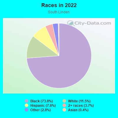
- 7,68773.8%Black
- 1,19711.5%White
- 8097.8%Hispanic or Latino
- 3873.7%Two or more races
- 2942.8%Some other race
- 440.4%Asian
- 40.04%American Indian
Distribution of median household income
![Distribution of median household income]()
- 552Less than $10,000
- 986$10,000 to $19,999
- 546$20,000 to $29,999
- 662$30,000 to $39,999
- 682$40,000 to $49,999
- 543$50,000 to $59,999
- 329$60,000 to $74,999
- 436$75,000 to $99,999
- 349$100,000 to $124,999
- 147$125,000 to $149,999
- 107$150,000 to $199,999
- 51$200,000 or more

Distribution of owner-occupied house/condo value
![Distribution of owner-occupied house/condo value]()
- 1,340Less than $50,000
- 1,267$50,000 to $99,999
- 416$100,000 to $149,999
- 623$150,000 to $199,999
- 88$200,000 to $249,999
- 61$250,000 to $299,999
- 677$300,000 to $399,999
- 12$400,000 to $499,999
- 131$500,000 to $749,999
- 11$750,000 to $999,999

Distribution of rent paid by renters
![Distribution of rent paid by renters]()
- 250Less than $100
- 961$100 to $199
- 73$200 to $299
- 421$300 to $399
- 368$400 to $499
- 454$500 to $599
- 408$600 to $699
- 682$700 to $799
- 728$800 to $899
- 291$900 to $999
- 338$1,000 to $1,249
- 246$1,250 to $1,499
- 517$1,500 to $1,999

| Males: | 4,120 |
| Females: | 5,785 |
Males:
| This neighborhood: | 27.1 years |
| Whole city: | 32.9 years |
| This neighborhood: | 32.7 years |
| Whole city: | 33.7 years |
Average household size:
| South Linden: | 2.6 people |
| Columbus: | 2.3 people |
Percentage of family households:
| South Linden: | 53.5% |
| Columbus: | 40.8% |
| Here: | 16.1% |
| Columbus: | 30.8% |
Percentage of married-couple families with children (among all households):
| South Linden: | 9.7% |
| Columbus: | 23.7% |
Percentage of single-mother households (among all households):
| South Linden: | 30.9% |
| Columbus: | 15.7% |
Percentage of never married males 15 years old and over:
Percentage of never married females 15 years old and over:
| South Linden: | 23.1% |
| Columbus: | 24.6% |
Percentage of never married females 15 years old and over:
| South Linden: | 33.3% |
| city: | 21.9% |
Percentage of people that speak English not well or not at all:
| South Linden: | 1.7% |
| Columbus: | 3.5% |
Percentage of people born in this state:
Percentage of people born in another U.S. state:
Percentage of native residents but born outside the U.S.:
Percentage of foreign born residents:
| Here: | 79.0% |
| Columbus: | 61.6% |
Percentage of people born in another U.S. state:
| South Linden: | 16.2% |
| Columbus: | 22.4% |
Percentage of native residents but born outside the U.S.:
| Here: | 1.2% |
| city: | 1.3% |
Percentage of foreign born residents:
| Here: | 4.1% |
| Columbus: | 14.7% |
Owner-occupied
Renter-occupied

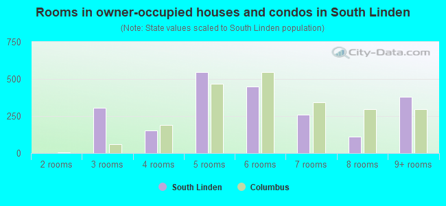
- Rooms in owner-occupied houses and condos in South Linden
- 01 room
- 02 rooms
- 3043 rooms
- 1554 rooms
- 5485 rooms
- 4506 rooms
- 2597 rooms
- 1098 rooms
- 3789+ rooms
- Rooms in renter-occupied apartments in South Linden
- 3701 room
- 662 rooms
- 1603 rooms
- 5404 rooms
- 9015 rooms
- 7916 rooms
- 2037 rooms
- 3838 rooms
- 1419+ rooms
Owner-occupied
Renter-occupied
- Bedrooms in owner-occupied houses and condos in South Linden
- 5no bedroom
- 721 bedroom
- 4862 bedrooms
- 7003 bedrooms
- 2814 bedrooms
- 85+ bedrooms
- Bedrooms in renter-occupied apartments in South Linden
- 370no bedroom
- 651 bedroom
- 1,0072 bedrooms
- 1,2013 bedrooms
- 2754 bedrooms
- 1915+ bedrooms
Average number of cars or other vehicles available in houses/condos:
Average number of cars or other vehicles available in apartments:
| This neighborhood: | 1.3 |
| Columbus: | 1.8 |
Average number of cars or other vehicles available in apartments:
| Here: | 1.1 |
| city: | 1.3 |
Percentage of units with a mortgage:
| South Linden: | 52.6% |
| Columbus: | 69.3% |
Average estimated value of detached houses in 2022 (72.8% of all units):
| South Linden: | $96,873 |
| Columbus: | $262,671 |

- Year house built in South Linden
- 02020 or later
- 2102010 to 2019
- 6622000 to 2009
- 5361990 to 1999
- 1811980 to 1989
- 4211970 to 1979
- 8251960 to 1969
- 8701950 to 1959
- 1,0031940 to 1949
- 9461939 or earlier
City-data.com crime index for city in 2020 (higher means more crime):
| City: | 376.1 |
| U.S. average: | 219.5 |
Travel time to work (commute)
![Travel time to work (commute)]()
- 24Less than 5 minutes
- 4165 to 9 minutes
- 44510 to 14 minutes
- 66915 to 19 minutes
- 87520 to 24 minutes
- 22825 to 29 minutes
- 25830 to 34 minutes
- 5235 to 39 minutes
- 7540 to 44 minutes
- 8845 to 59 minutes
- 6260 to 89 minutes
- 9690 or more minutes

Means of transportation to work
![Means of transportation to work]()
- 59.8%1,978Drove a car alone
- 16.3%538Carpooled
- 12.2%404Bus
- 17.1%566Taxi
- 7.3%240Walked
- 34.2%1,130Other means
- 8.9%295Worked at home

Time leaving home to go to work
![Time leaving home to go to work]()
- 14212:00 a.m. to 4:59 a.m.
- 1885:00 a.m. to 5:29 a.m.
- 1475:30 a.m. to 5:59 a.m.
- 1366:00 a.m. to 6:29 a.m.
- 2696:30 a.m. to 6:59 a.m.
- 4447:00 a.m. to 7:29 a.m.
- 1837:30 a.m. to 7:59 a.m.
- 4738:00 a.m. to 8:29 a.m.
- 1218:30 a.m. to 8:59 a.m.
- 1289:00 a.m. to 9:59 a.m.
- 20510:00 a.m. to 10:59 a.m.
- 6611:00 a.m. to 11:59 a.m.
- 46212:00 p.m. to 3:59 p.m.
- 2824:00 p.m. to 11:59 p.m.

Occupations of males:
- Percentage of males in management occupations (except farmers):
Here: 5.5% city: 10.2%
- Percentage of males in business and financial operations occupations:
Here: 2.1% city: 6.2%
- Percentage of males in community and social services occupations:
Here: 1.4% city: 1.2%
- Percentage of males in service occupations:
Here: 30.4% city: 13.8%
- Percentage of males in sales and office occupations:
Here: 20.9% city: 17.0%
- Percentage of males in construction, extraction, and maintenance occupations:
Here: 8.3% city: 5.2%
- Percentage of males in production occupations:
Here: 8.4% city: 6.5%
- Percentage of males in transportation occupations:
Here: 4.8% city: 6.4%
- Percentage of males in material moving occupations:
Here: 11.5% city: 7.9%
Occupations of females:
- Percentage of females in management occupations (except farmers):
Here: 2.5% city: 10.0%
- Percentage of females in business and financial operations occupations:
Here: 2.5% city: 8.2%
- Percentage of females in computer and mathematical occupations:
Here: 1.3% city: 2.6%
- Percentage of females in community and social services occupations:
Here: 5.4% city: 3.0%
- Percentage of females in education, training, and library occupations:
Here: 1.4% city: 7.9%
- Percentage of females in healthcare practitioners and technical occupations:
Here: 11.4% city: 10.2%
- Percentage of females in service occupations:
Here: 39.0% city: 19.3%
- Percentage of females in sales and office occupations:
Here: 27.4% city: 25.0%
- Percentage of females in production occupations:
Here: 2.2% city: 3.0%
- Percentage of females in transportation occupations:
Here: 1.9% city: 1.3%
- Percentage of females in material moving occupations:
Here: 4.7% city: 3.7%
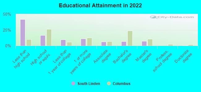
Education in this neighborhood (subdivision or community):
- Percentage of people 3 years and older in K-12 schools:
South Linden: 40.7% Columbus: 15.2%
- Percentage of people 3 years and older in undergraduate colleges:
South Linden: 6.6% Columbus: 6.7%
- Percentage of people 3 years and older in grad. or professional schools:
South Linden: 1.5% Columbus: 2.4%
- Percentage of students K-12 enrolled in private schools:
South Linden: 31.4% Columbus: 13.8%
Percentage of population below poverty level:
| South Linden: | 45.8% |
| Columbus: | 18.1% |
Percentage of married-couple families with both working:
| South Linden: | 138.9% |
| Columbus: | 75.5% |
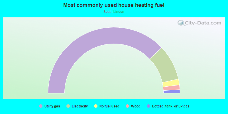
- 75.7%Utility gas
- 17.4%Electricity
- 2.9%No fuel used
- 2.3%Wood
- 1.7%Bottled, tank, or LP gas
Limited-access highways (interstate or state) in this neighborhood:
I- 71 (North Fwy)
Length: 3.43 miles
Directions: N-S, SE-NW
Directions: N-S, SE-NW
Highways in this neighborhood:
Cleveland Ave (State Rte 3)
Length: 1.88 miles
Direction: SW-NE
Address range: 1291 to 2289
Direction: SW-NE
Address range: 1291 to 2289
Roads and streets:
E Hudson St
Length: 1.86 miles
Direction: E-W
Address range: 567 to 1624
Direction: E-W
Address range: 567 to 1624
E Maynard Ave
Length: 1.38 miles
Directions: E-W, SE-NW
Address range: 713 to 1601
Directions: E-W, SE-NW
Address range: 713 to 1601
Clinton St
Length: 1.21 miles
Direction: E-W
Address range: 700 to 1382
Direction: E-W
Address range: 700 to 1382
Hamilton Ave
Length: 1.18 miles
Direction: N-S
Address range: 1547 to 2368
Direction: N-S
Address range: 1547 to 2368
Duxberry Ave
Length: 1.18 miles
Direction: E-W
Address range: 957 to 1582
Direction: E-W
Address range: 957 to 1582
E 26th Ave
Length: 1.17 miles
Direction: E-W
Address range: 945 to 1563
Direction: E-W
Address range: 945 to 1563
E 22nd Ave
Length: 1.10 miles
Direction: E-W
Address range: 915 to 1505
Direction: E-W
Address range: 915 to 1505
E 21st Ave
Length: 1.10 miles
Direction: E-W
Address range: 889 to 1499
Direction: E-W
Address range: 889 to 1499
E 20th Ave
Length: 1.07 miles
Direction: E-W
Address range: 883 to 1499
Direction: E-W
Address range: 883 to 1499
E 17th Ave
Length: 1.05 miles
Direction: E-W
Address range: 861 to 1418
Direction: E-W
Address range: 861 to 1418
E 19th Ave
Length: 1.05 miles
Direction: E-W
Address range: 873 to 1499
Direction: E-W
Address range: 873 to 1499
E 18th Ave
Length: 1.01 miles
Direction: E-W
Address range: 849 to 1499
Direction: E-W
Address range: 849 to 1499
Jefferson Ave
Length: 0.99 miles
Direction: N-S
Address range: 1399 to 2386
Direction: N-S
Address range: 1399 to 2386
Billiter Blvd
Length: 0.96 miles
Directions: N-S, SW-NE
Directions: N-S, SW-NE
Ontario St
Length: 0.95 miles
Direction: N-S
Address range: 1700 to 2352
Direction: N-S
Address range: 1700 to 2352
Lexington Ave
Length: 0.92 miles
Direction: N-S
Address range: 1567 to 2398
Direction: N-S
Address range: 1567 to 2398
E 25th Ave
Length: 0.89 miles
Direction: E-W
Address range: 1100 to 1574
Direction: E-W
Address range: 1100 to 1574
E 24th Ave
Length: 0.87 miles
Direction: E-W
Address range: 1065 to 1536
Direction: E-W
Address range: 1065 to 1536
E 23rd Ave
Length: 0.85 miles
Direction: E-W
Address range: 1057 to 1530
Direction: E-W
Address range: 1057 to 1530
E 15th Ave
Length: 0.84 miles
Direction: E-W
Address range: 915 to 1362
Direction: E-W
Address range: 915 to 1362
E 16th Ave
Length: 0.77 miles
Direction: E-W
Address range: 963 to 1380
Direction: E-W
Address range: 963 to 1380
E 12th Ave
Length: 0.75 miles
Direction: E-W
Address range: 801 to 1254
Direction: E-W
Address range: 801 to 1254
Bonham Ave
Length: 0.69 miles
Directions: E-W, SE-NW
Address range: 799 to 1310
Directions: E-W, SE-NW
Address range: 799 to 1310
Grasmere Ave
Length: 0.67 miles
Directions: E-W, N-S, SE-NW
Address range: 1977 to 2399
Directions: E-W, N-S, SE-NW
Address range: 1977 to 2399
Kohr Pl
Length: 0.65 miles
Direction: E-W
Address range: 1301 to 1665
Direction: E-W
Address range: 1301 to 1665
E Blake Ave
Length: 0.60 miles
Direction: E-W
Address range: 1293 to 1621
Direction: E-W
Address range: 1293 to 1621
E 13th Ave
Length: 0.58 miles
Direction: E-W
Address range: 847 to 1168
Direction: E-W
Address range: 847 to 1168
Brooks Ave
Length: 0.58 miles
Directions: N-S, SW-NE
Address range: 1335 to 1680
Directions: N-S, SW-NE
Address range: 1335 to 1680
Chittenden Ave
Length: 0.56 miles
Directions: E-W, SE-NW
Address range: 800 to 1199
Directions: E-W, SE-NW
Address range: 800 to 1199
Windsor Ave
Length: 0.51 miles
Direction: E-W
Address range: 1097 to 1356
Direction: E-W
Address range: 1097 to 1356
Medina Ave
Length: 0.50 miles
Direction: N-S
Address range: 1900 to 2328
Direction: N-S
Address range: 1900 to 2328
Kenmore Rd
Length: 0.49 miles
Direction: E-W
Address range: 1395 to 1651
Direction: E-W
Address range: 1395 to 1651
Howey Rd
Length: 0.49 miles
Direction: N-S
Address range: 1855 to 2408
Direction: N-S
Address range: 1855 to 2408
Cordell Ave
Length: 0.47 miles
Direction: E-W
Address range: 1380 to 1628
Direction: E-W
Address range: 1380 to 1628
Hiawatha Park Dr
Length: 0.42 miles
Directions: N-S, SW-NE
Address range: 2199 to 2424
Directions: N-S, SW-NE
Address range: 2199 to 2424
E 14th Ave
Length: 0.41 miles
Direction: E-W
Address range: 845 to 1112
Direction: E-W
Address range: 845 to 1112
Gladstone Ave
Length: 0.41 miles
Direction: N-S
Address range: 1689 to 1976
Direction: N-S
Address range: 1689 to 1976
E 11th Ave
Length: 0.41 miles
Direction: E-W
Address range: 775 to 1012
Direction: E-W
Address range: 775 to 1012
Dresden St
Length: 0.40 miles
Direction: N-S
Address range: 2045 to 2323
Direction: N-S
Address range: 2045 to 2323
Gerbert Rd
Length: 0.40 miles
Direction: N-S
Address range: 2085 to 2358
Direction: N-S
Address range: 2085 to 2358
Louis Ave
Length: 0.37 miles
Direction: N-S
Address range: 1401 to 1799
Direction: N-S
Address range: 1401 to 1799
Mc Guffey Rd
Length: 0.34 miles
Direction: N-S
Address range: 2127 to 2399
Direction: N-S
Address range: 2127 to 2399
Homestead Dr
Length: 0.34 miles
Direction: N-S
Address range: 2100 to 2332
Direction: N-S
Address range: 2100 to 2332
Atwood Ter
Length: 0.31 miles
Direction: N-S
Address range: 2200 to 2399
Direction: N-S
Address range: 2200 to 2399
St Clair Ave
Length: 0.31 miles
Directions: N-S, SW-NE
Address range: 1329 to 1870
Directions: N-S, SW-NE
Address range: 1329 to 1870
Indigo Way
Length: 0.30 miles
Directions: E-W, N-S, SW-NE
Address range: 1001 to 1199
Directions: E-W, N-S, SW-NE
Address range: 1001 to 1199
Velma Ave
Length: 0.27 miles
Direction: N-S
Address range: 2248 to 2434
Direction: N-S
Address range: 2248 to 2434
Kingry St
Length: 0.26 miles
Directions: N-S, SW-NE
Address range: 1300 to 1534
Directions: N-S, SW-NE
Address range: 1300 to 1534
Pontiac St
Length: 0.24 miles
Direction: N-S
Address range: 2275 to 2438
Direction: N-S
Address range: 2275 to 2438
Rosewind Dr
Length: 0.24 miles
Direction: E-W
Address range: 1052 to 1156
Direction: E-W
Address range: 1052 to 1156
Vesta Ave
Length: 0.21 miles
Directions: E-W, N-S, SW-NE
Address range: 1077 to 1151
Directions: E-W, N-S, SW-NE
Address range: 1077 to 1151
Isabel Ave
Length: 0.20 miles
Directions: N-S, SW-NE
Address range: 1486 to 1599
Directions: N-S, SW-NE
Address range: 1486 to 1599
E Tompkins St
Length: 0.15 miles
Direction: E-W
Address range: 1341 to 1399
Direction: E-W
Address range: 1341 to 1399
Mc Clelland Ave
Length: 0.14 miles
Directions: E-W, SW-NE
Address range: 900 to 1016
Directions: E-W, SW-NE
Address range: 900 to 1016
Wright Ave
Length: 0.13 miles
Direction: N-S
Address range: 1420 to 1461
Direction: N-S
Address range: 1420 to 1461
Bremen St
Length: 0.11 miles
Direction: N-S
Address range: 2227 to 2305
Direction: N-S
Address range: 2227 to 2305
Cleophus Kee Blvd (Cleophus Kee Ave)
Length: 0.10 miles
Direction: N-S
Address range: 1500 to 1599
Direction: N-S
Address range: 1500 to 1599
Gerald Ave
Length: 0.09 miles
Direction: N-S
Direction: N-S
Dolle Ave
Length: 0.09 miles
Direction: N-S
Address range: 1315 to 1363
Direction: N-S
Address range: 1315 to 1363
Gerald Ave (13th Ave)
Length: 0.09 miles
Directions: N-S, SW-NE
Directions: N-S, SW-NE
Terrace Ln
Length: 0.08 miles
Direction: N-S
Address range: 1346 to 1386
Direction: N-S
Address range: 1346 to 1386
Service Rd
Length: 0.07 miles
Direction: SE-NW
Direction: SE-NW
Nightfall Ct
Length: 0.07 miles
Directions: E-W, N-S
Directions: E-W, N-S
Nightfall Cir
Length: 0.07 miles
Direction: N-S
Address range: 1484 to 1524
Direction: N-S
Address range: 1484 to 1524
Trailway St
Length: 0.06 miles
Direction: N-S
Address range: 1324 to 1399
Direction: N-S
Address range: 1324 to 1399
Accomodation Ave
Length: 0.04 miles
Directions: E-W, N-S
Address range: 1516 to 1547
Directions: E-W, N-S
Address range: 1516 to 1547
12th Ave
Length: 0.04 miles
Direction: E-W
Direction: E-W
Bancroft St
Length: 0.03 miles
Direction: N-S
Address range: 1939 to 1952
Direction: N-S
Address range: 1939 to 1952
25th Ave
Length: 0.00 miles
Direction: E-W
Direction: E-W