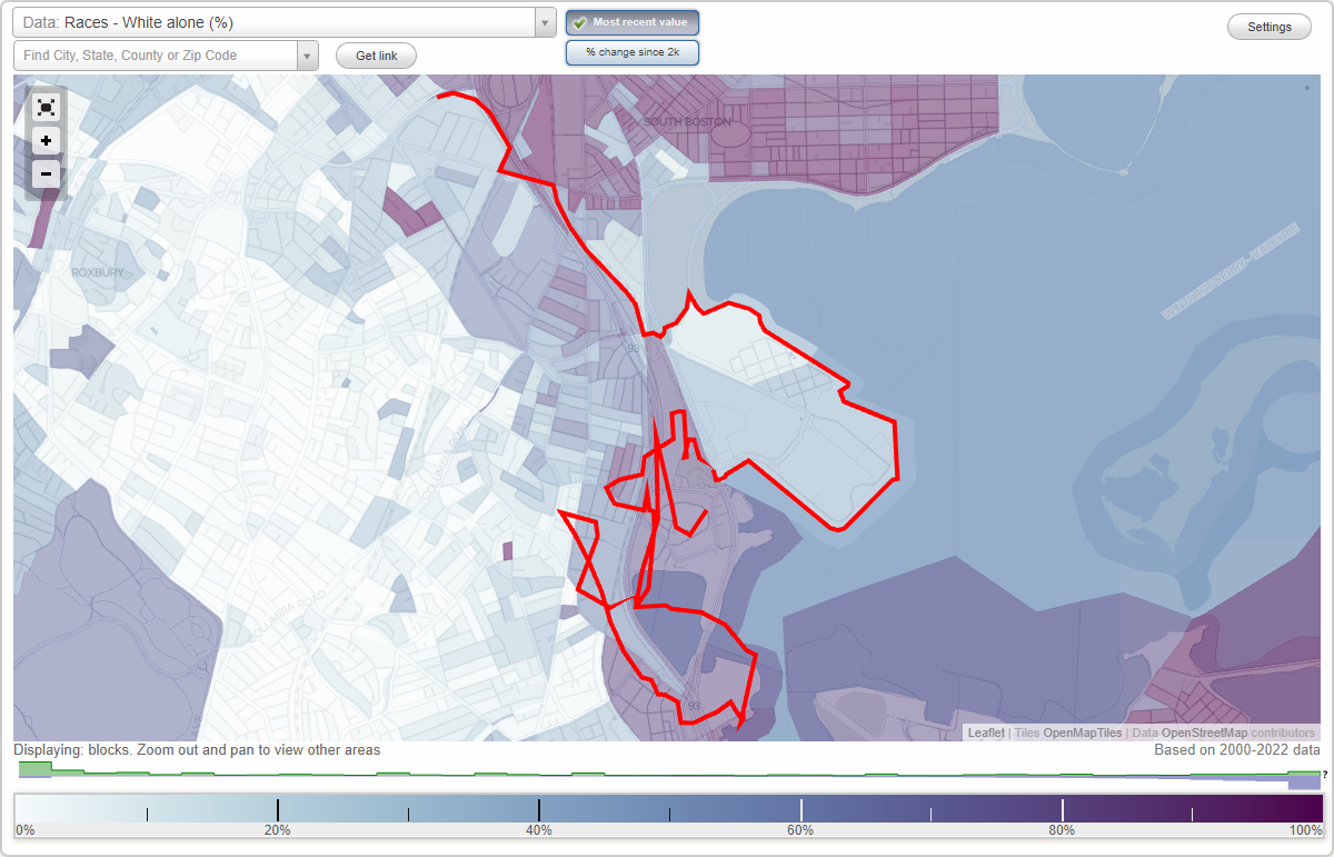
Columbia Point (Columbia Pt) neighborhood in Boston, Massachusetts (MA), 02125, 02118 detailed profile
Settings
X

Business Search - 14 Million verified businesses
Area: 1.646 square miles
Population: 21,829
Population density:
| Columbia Point (Columbia Pt): | 13,263 people per square mile |
| Boston: | 13,418 people per square mile |

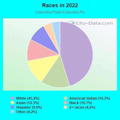
- 11,95045.2%White
- 3,77614.3%American Indian
- 3,24512.3%Asian
- 2,83810.7%Black
- 2,3879.0%Hispanic or Latino
- 1,0994.2%Some other race
- 1,1204.2%Two or more races
Distribution of median household income
![Distribution of median household income]()
- 1,332Less than $10,000
- 1,566$10,000 to $19,999
- 1,182$20,000 to $29,999
- 1,405$30,000 to $39,999
- 466$40,000 to $49,999
- 637$50,000 to $59,999
- 598$60,000 to $74,999
- 800$75,000 to $99,999
- 938$100,000 to $124,999
- 825$125,000 to $149,999
- 1,644$150,000 to $199,999
- 1,390$200,000 or more

Distribution of owner-occupied house/condo value
![Distribution of owner-occupied house/condo value]()
- 1,725Less than $50,000
- 700$50,000 to $99,999
- 131$100,000 to $149,999
- 1,292$150,000 to $199,999
- 34$200,000 to $249,999
- 31$250,000 to $299,999
- 264$300,000 to $399,999
- 474$400,000 to $499,999
- 1,767$500,000 to $749,999
- 920$750,000 to $999,999
- 2,354$1,000,000 or more

Distribution of rent paid by renters
![Distribution of rent paid by renters]()
- 875Less than $100
- 3,605$100 to $199
- 1,766$200 to $299
- 2,220$300 to $399
- 1,443$400 to $499
- 1,090$500 to $599
- 3,162$600 to $699
- 461$700 to $799
- 481$800 to $899
- 388$900 to $999
- 849$1,000 to $1,249
- 425$1,250 to $1,499
- 1,151$1,500 to $1,999
- 3,448$2,000 or more

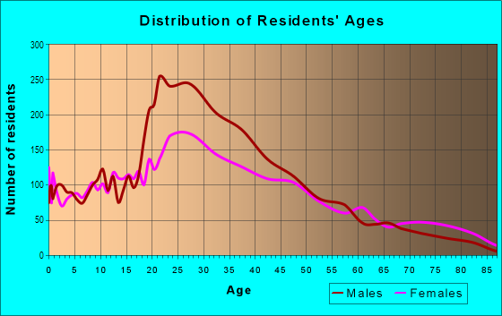
| Males: | 10,330 |
| Females: | 11,498 |
Males:
| This neighborhood: | 35.9 years |
| Whole city: | 32.7 years |
| This neighborhood: | 38.3 years |
| Whole city: | 34.1 years |
Average household size:
| Columbia Point (Columbia Pt): | 4.2 people |
| Boston: | 2.1 people |
Percentage of family households:
| Columbia Point (Columbia Pt): | 27.8% |
| Boston: | 34.5% |
| Here: | 22.2% |
| Boston: | 26.9% |
Percentage of married-couple families with children (among all households):
| Columbia Point (Columbia Pt): | 24.7% |
| Boston: | 24.9% |
Percentage of single-mother households (among all households):
| Columbia Point (Columbia Pt): | 18.0% |
| Boston: | 15.7% |
Percentage of never married males 15 years old and over:
Percentage of never married females 15 years old and over:
| Columbia Point (Columbia Pt): | 27.8% |
| Boston: | 26.8% |
Percentage of never married females 15 years old and over:
| Columbia Point (Columbia Pt): | 32.6% |
| city: | 28.3% |
Percentage of people that speak English not well or not at all:
| Columbia Point (Columbia Pt): | 8.5% |
| Boston: | 8.0% |
Percentage of people born in this state:
Percentage of people born in another U.S. state:
Percentage of native residents but born outside the U.S.:
Percentage of foreign born residents:
| Here: | 50.2% |
| Boston: | 42.4% |
Percentage of people born in another U.S. state:
| Columbia Point (Columbia Pt): | 20.2% |
| Boston: | 26.6% |
Percentage of native residents but born outside the U.S.:
| Here: | 3.5% |
| city: | 3.3% |
Percentage of foreign born residents:
| Here: | 26.1% |
| Boston: | 27.6% |
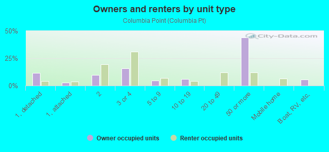
Owner-occupied
Renter-occupied

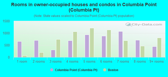
- Rooms in owner-occupied houses and condos in Columbia Point <
> - 6571 room
- 6992 rooms
- 3113 rooms
- 6914 rooms
- 9315 rooms
- 8826 rooms
- 1,0777 rooms
- 7188 rooms
- 4469+ rooms
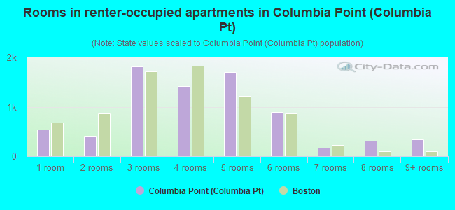
- Rooms in renter-occupied apartments in Columbia Point <
> - 5441 room
- 4092 rooms
- 1,8153 rooms
- 1,4134 rooms
- 1,6965 rooms
- 8896 rooms
- 1747 rooms
- 3138 rooms
- 3389+ rooms
Owner-occupied
Renter-occupied
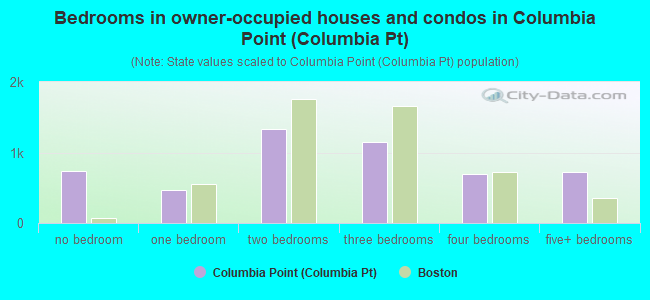
- Bedrooms in owner-occupied houses and condos in Columbia Point <
> - 742no bedroom
- 4681 bedroom
- 1,3352 bedrooms
- 1,1463 bedrooms
- 6974 bedrooms
- 7285+ bedrooms
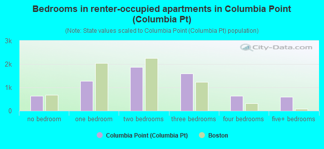
- Bedrooms in renter-occupied apartments in Columbia Point <
> - 631no bedroom
- 1,2871 bedroom
- 1,8672 bedrooms
- 1,5973 bedrooms
- 6304 bedrooms
- 6055+ bedrooms
Average number of cars or other vehicles available in houses/condos:
Average number of cars or other vehicles available in apartments:
| This neighborhood: | 1.4 |
| Boston: | 1.4 |
Average number of cars or other vehicles available in apartments:
| Here: | 0.8 |
| city: | 0.7 |
Percentage of units with a mortgage:
| Columbia Point (Columbia Pt): | 63.7% |
| Boston: | 69.7% |
Housing prices:
- Average estimated value of detached houses in 2022 (11.5% of all units):
Columbia Point (Columbia Pt): $520,211 Massachusetts: $651,570
- Average estimated value of housing units in 2-unit structures in 2022 (16.4% of all units):
This neighborhood: $685,854 Massachusetts: $594,808
- Average estimated '22 value of housing units in 3-to-4-unit structures (56.0% of all units):
Columbia Point (Columbia Pt): $772,373 Massachusetts: $601,912
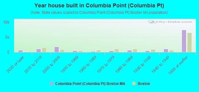
- Year house built in Columbia Point <
> - 7162020 or later
- 1,1292010 to 2019
- 1,8192000 to 2009
- 5441990 to 1999
- 2561980 to 1989
- 5541970 to 1979
- 6651960 to 1969
- 4761950 to 1959
- 1,1061940 to 1949
- 7,4011939 or earlier
City-data.com crime index for city in 2020 (higher means more crime):
| City: | 258.2 |
| U.S. average: | 219.5 |
Travel time to work (commute)
![Travel time to work (commute)]()
- 515Less than 5 minutes
- 3145 to 9 minutes
- 57610 to 14 minutes
- 1,55515 to 19 minutes
- 1,47620 to 24 minutes
- 1,00625 to 29 minutes
- 2,85930 to 34 minutes
- 38635 to 39 minutes
- 54740 to 44 minutes
- 1,56545 to 59 minutes
- 71260 to 89 minutes
- 35490 or more minutes

Means of transportation to work
![Means of transportation to work]()
- 31.1%3,978Drove a car alone
- 9.2%1,180Carpooled
- 16.6%2,123Bus
- 25.5%3,265Subway or elevated rail
- 2.5%326Long-distance train or commuter rail
- 5.7%733Light rail, streetcar or trolley
- 3.5%451Taxi
- 3.3%423Bicycle
- 11.5%1,467Walked
- 1.8%234Other means
- 10.2%1,310Worked at home

Time leaving home to go to work
![Time leaving home to go to work]()
- 19012:00 a.m. to 4:59 a.m.
- 5355:00 a.m. to 5:29 a.m.
- 3705:30 a.m. to 5:59 a.m.
- 6896:00 a.m. to 6:29 a.m.
- 6576:30 a.m. to 6:59 a.m.
- 1,6177:00 a.m. to 7:29 a.m.
- 1,1347:30 a.m. to 7:59 a.m.
- 2,3918:00 a.m. to 8:29 a.m.
- 1,0328:30 a.m. to 8:59 a.m.
- 1,6849:00 a.m. to 9:59 a.m.
- 33810:00 a.m. to 10:59 a.m.
- 4411:00 a.m. to 11:59 a.m.
- 97912:00 p.m. to 3:59 p.m.
- 4674:00 p.m. to 11:59 p.m.

Occupations of males:
- Percentage of males in management occupations (except farmers):
Here: 15.4% city: 12.7%
- Percentage of males in business and financial operations occupations:
Here: 7.3% city: 9.1%
- Percentage of males in computer and mathematical occupations:
Here: 10.0% city: 7.4%
- Percentage of males in architecture and engineering occupations:
Here: 3.5% city: 3.1%
- Percentage of males in life, physical, and social science occupations:
Here: 5.8% city: 3.9%
- Percentage of males in education, training, and library occupations:
Here: 3.5% city: 5.7%
- Percentage of males in arts, design, entertainment, sports, and media occupations:
Here: 4.4% city: 2.7%
- Percentage of males in healthcare practitioners and technical occupations:
Here: 2.6% city: 4.4%
- Percentage of males in service occupations:
Here: 13.3% city: 16.0%
- Percentage of males in sales and office occupations:
Here: 15.9% city: 15.2%
- Percentage of males in construction, extraction, and maintenance occupations:
Here: 7.5% city: 4.4%
- Percentage of males in production occupations:
Here: 3.8% city: 2.4%
- Percentage of males in transportation occupations:
Here: 2.1% city: 4.7%
Occupations of females:
- Percentage of females in management occupations (except farmers):
Here: 14.7% city: 12.2%
- Percentage of females in business and financial operations occupations:
Here: 12.5% city: 9.5%
- Percentage of females in computer and mathematical occupations:
Here: 3.7% city: 3.2%
- Percentage of females in architecture and engineering occupations:
Here: 1.4% city: 1.0%
- Percentage of females in life, physical, and social science occupations:
Here: 4.9% city: 3.3%
- Percentage of females in community and social services occupations:
Here: 2.8% city: 3.1%
- Percentage of females in legal occupations:
Here: 1.2% city: 2.3%
- Percentage of females in education, training, and library occupations:
Here: 7.9% city: 9.4%
- Percentage of females in arts, design, entertainment, sports, and media occupations:
Here: 2.0% city: 3.4%
- Percentage of females in healthcare practitioners and technical occupations:
Here: 7.4% city: 10.2%
- Percentage of females in service occupations:
Here: 16.6% city: 18.6%
- Percentage of females in sales and office occupations:
Here: 19.2% city: 20.2%
- Percentage of females in production occupations:
Here: 4.4% city: 1.5%
- Percentage of females in transportation occupations:
Here: 1.3% city: 0.8%
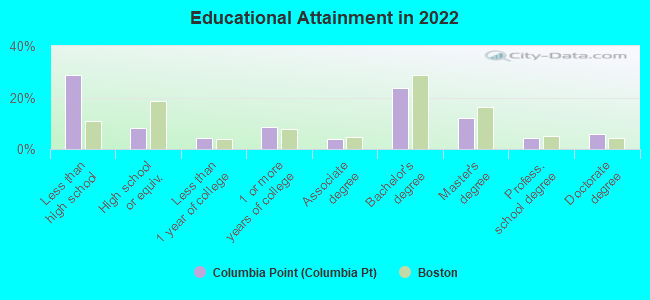
Education in this neighborhood (subdivision or community):
- Percentage of people 3 years and older in K-12 schools:
Columbia Point (Columbia Pt): 22.0% Boston: 11.0%
- Percentage of people 3 years and older in undergraduate colleges:
Columbia Point (Columbia Pt): 6.0% Boston: 11.0%
- Percentage of people 3 years and older in grad. or professional schools:
Columbia Point (Columbia Pt): 6.5% Boston: 4.3%
- Percentage of students K-12 enrolled in private schools:
Columbia Point (Columbia Pt): 67.4% Boston: 13.8%
Percentage of population below poverty level:
| Columbia Point (Columbia Pt): | 16.5% |
| Boston: | 17.1% |
Median year renter moved in (as recorded in 2022):
| Columbia Point (Columbia Pt): | 2015 |
| Boston: | 2020 |
Percentage of married-couple families with both working:
| Columbia Point (Columbia Pt): | 398.5% |
| Boston: | 78.2% |
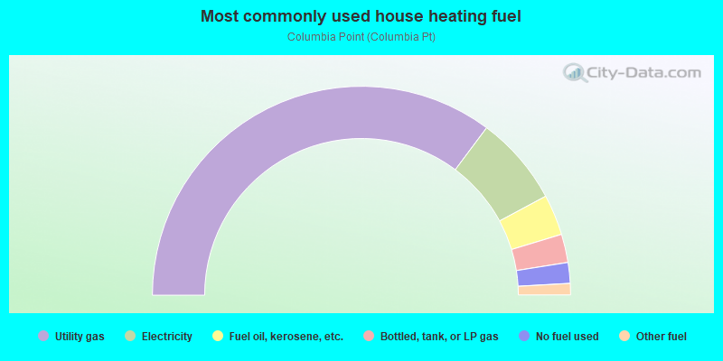
- 70.5%Utility gas
- 13.9%Electricity
- 6.3%Fuel oil, kerosene, etc.
- 4.4%Bottled, tank, or LP gas
- 3.2%No fuel used
- 1.8%Other fuel
Limited-access highways (interstate or state) in this neighborhood:
US Hwy 1 (State Hwy 3, I- 93, John F Fitzgerald Expy, General Pulaski Skwy)
Length: 4.81 miles
Directions: N-S, SE-NW, SW-NE
Directions: N-S, SE-NW, SW-NE
Roads and streets:
William T Morrissey Blvd
Length: 2.66 miles
Directions: N-S, SE-NW, SW-NE
Address range: 2 to 643
Directions: N-S, SE-NW, SW-NE
Address range: 2 to 643
Mount Vernon St
Length: 1.81 miles
Directions: E-W, N-S, SE-NW, SW-NE
Address range: 1 to 499
Directions: E-W, N-S, SE-NW, SW-NE
Address range: 1 to 499
Savin Hill Ave
Length: 1.54 miles
Directions: E-W, N-S, SE-NW, SW-NE
Address range: 20 to 498
Directions: E-W, N-S, SE-NW, SW-NE
Address range: 20 to 498
Dorchester Ave
Length: 1.27 miles
Direction: N-S
Address range: 700 to 1244
Direction: N-S
Address range: 700 to 1244
Massachusetts Ave
Length: 0.89 miles
Direction: SE-NW
Address range: 926 to 1299
Direction: SE-NW
Address range: 926 to 1299
Newmarket Sq
Length: 0.76 miles
Directions: E-W, N-S, SE-NW, SW-NE
Address range: 1 to 199
Directions: E-W, N-S, SE-NW, SW-NE
Address range: 1 to 199
Sydney St
Length: 0.69 miles
Directions: N-S, SE-NW, SW-NE
Address range: 1 to 299
Directions: N-S, SE-NW, SW-NE
Address range: 1 to 299
Grampian Way
Length: 0.65 miles
Directions: E-W, N-S, SE-NW, SW-NE
Address range: 1 to 203
Directions: E-W, N-S, SE-NW, SW-NE
Address range: 1 to 203
Columbia Rd
Length: 0.65 miles
Directions: E-W, SE-NW, SW-NE
Address range: 712 to 899
Directions: E-W, SE-NW, SW-NE
Address range: 712 to 899
Auckland St
Length: 0.57 miles
Directions: E-W, N-S, SW-NE
Address range: 1 to 199
Directions: E-W, N-S, SW-NE
Address range: 1 to 199
Boston St
Length: 0.55 miles
Directions: N-S, SW-NE
Address range: 62 to 299
Directions: N-S, SW-NE
Address range: 62 to 299
Southampton St
Length: 0.54 miles
Direction: E-W
Address range: 70 to 299
Direction: E-W
Address range: 70 to 299
Harbor Point Blvd
Length: 0.50 miles
Directions: E-W, SW-NE
Address range: 4 to 98
Directions: E-W, SW-NE
Address range: 4 to 98
Freeport St
Length: 0.46 miles
Directions: E-W, SE-NW
Address range: 173 to 399
Directions: E-W, SE-NW
Address range: 173 to 399
N Point Dr
Length: 0.45 miles
Directions: E-W, N-S, SE-NW
Address range: 1 to 199
Directions: E-W, N-S, SE-NW
Address range: 1 to 199
Ocean View Dr
Length: 0.39 miles
Directions: E-W, SE-NW
Address range: 1 to 112
Directions: E-W, SE-NW
Address range: 1 to 112
S Bay Ave
Length: 0.37 miles
Directions: E-W, SE-NW, SW-NE
Address range: 1 to 99
Directions: E-W, SE-NW, SW-NE
Address range: 1 to 99
Westwind Rd
Length: 0.33 miles
Directions: E-W, SE-NW
Address range: 1 to 99
Directions: E-W, SE-NW
Address range: 1 to 99
Buttonwood St
Length: 0.33 miles
Direction: N-S
Address range: 1 to 199
Direction: N-S
Address range: 1 to 199
Roseclair St
Length: 0.33 miles
Directions: E-W, SW-NE
Address range: 1 to 99
Directions: E-W, SW-NE
Address range: 1 to 99
Beach Point Pl
Length: 0.32 miles
Directions: E-W, SE-NW
Address range: 1 to 99
Directions: E-W, SE-NW
Address range: 1 to 99
Edison Green
Length: 0.31 miles
Direction: E-W
Address range: 1 to 99
Direction: E-W
Address range: 1 to 99
Romsey St
Length: 0.29 miles
Direction: E-W
Address range: 1 to 99
Direction: E-W
Address range: 1 to 99
Harbor View St
Length: 0.29 miles
Direction: E-W
Address range: 1 to 99
Direction: E-W
Address range: 1 to 99
Sudan St
Length: 0.29 miles
Direction: E-W
Address range: 1 to 99
Direction: E-W
Address range: 1 to 99
Sagamore St
Length: 0.28 miles
Direction: N-S
Address range: 1 to 99
Direction: N-S
Address range: 1 to 99
Crescent Ave
Length: 0.28 miles
Directions: E-W, SW-NE
Address range: 1 to 99
Directions: E-W, SW-NE
Address range: 1 to 99
Bay St
Length: 0.27 miles
Direction: E-W
Address range: 1 to 99
Direction: E-W
Address range: 1 to 99
E Cottage St
Length: 0.27 miles
Directions: E-W, SE-NW
Address range: 87 to 282
Directions: E-W, SE-NW
Address range: 87 to 282
N120
Length: 0.26 miles
Directions: E-W, SW-NE
Directions: E-W, SW-NE
Saxton St
Length: 0.26 miles
Directions: N-S, SW-NE
Address range: 1 to 199
Directions: N-S, SW-NE
Address range: 1 to 199
N433
Length: 0.25 miles
Direction: SE-NW
Direction: SE-NW
Enterprise St
Length: 0.25 miles
Directions: E-W, SE-NW, SW-NE
Address range: 1 to 99
Directions: E-W, SE-NW, SW-NE
Address range: 1 to 99
St Margaret St
Length: 0.25 miles
Directions: E-W, SE-NW
Address range: 1 to 99
Directions: E-W, SE-NW
Address range: 1 to 99
Harvest St
Length: 0.25 miles
Direction: E-W
Address range: 1 to 99
Direction: E-W
Address range: 1 to 99
Tuttle St
Length: 0.24 miles
Directions: N-S, SW-NE
Address range: 1 to 99
Directions: N-S, SW-NE
Address range: 1 to 99
Island View Pl
Length: 0.24 miles
Direction: E-W
Address range: 1 to 99
Direction: E-W
Address range: 1 to 99
Clapp St
Length: 0.23 miles
Directions: E-W, SE-NW, SW-NE
Address range: 1 to 99
Directions: E-W, SE-NW, SW-NE
Address range: 1 to 99
Mayhew St
Length: 0.22 miles
Direction: E-W
Address range: 1 to 99
Direction: E-W
Address range: 1 to 99
Dorset St
Length: 0.21 miles
Direction: E-W
Address range: 1 to 99
Direction: E-W
Address range: 1 to 99
Locust St
Length: 0.20 miles
Directions: E-W, SW-NE
Address range: 1 to 99
Directions: E-W, SW-NE
Address range: 1 to 99
Von Hillern St
Length: 0.20 miles
Directions: N-S, SE-NW
Address range: 66 to 70
Directions: N-S, SE-NW
Address range: 66 to 70
Peninsula Pl
Length: 0.20 miles
Directions: E-W, N-S, SE-NW, SW-NE
Address range: 1 to 99
Directions: E-W, N-S, SE-NW, SW-NE
Address range: 1 to 99
Belfort St
Length: 0.20 miles
Direction: E-W
Address range: 1 to 99
Direction: E-W
Address range: 1 to 99
Bradston St
Length: 0.19 miles
Directions: E-W, N-S, SE-NW, SW-NE
Address range: 1 to 99
Directions: E-W, N-S, SE-NW, SW-NE
Address range: 1 to 99
Moseley St
Length: 0.19 miles
Directions: N-S, SE-NW, SW-NE
Address range: 1 to 98
Directions: N-S, SE-NW, SW-NE
Address range: 1 to 98
Bellflower St
Length: 0.18 miles
Direction: E-W
Address range: 1 to 99
Direction: E-W
Address range: 1 to 99
Topeka St
Length: 0.18 miles
Direction: SW-NE
Address range: 1 to 199
Direction: SW-NE
Address range: 1 to 199
Norfolk Ave
Length: 0.18 miles
Direction: SE-NW
Address range: 290 to 399
Direction: SE-NW
Address range: 290 to 399
S Point Dr
Length: 0.18 miles
Directions: SE-NW, SW-NE
Address range: 1 to 99
Directions: SE-NW, SW-NE
Address range: 1 to 99
Theodore Glynn Way
Length: 0.17 miles
Direction: SW-NE
Address range: 1 to 99
Direction: SW-NE
Address range: 1 to 99
Harbor Crest Ct
Length: 0.16 miles
Directions: E-W, N-S, SE-NW
Address range: 1 to 99
Directions: E-W, N-S, SE-NW
Address range: 1 to 99
Washburn St
Length: 0.16 miles
Directions: E-W, N-S, SE-NW, SW-NE
Address range: 1 to 46
Directions: E-W, N-S, SE-NW, SW-NE
Address range: 1 to 46
Doris St
Length: 0.16 miles
Direction: E-W
Address range: 1 to 99
Direction: E-W
Address range: 1 to 99
Howell St
Length: 0.16 miles
Direction: E-W
Address range: 1 to 99
Direction: E-W
Address range: 1 to 99
Deer St
Length: 0.15 miles
Directions: N-S, SW-NE
Address range: 1 to 99
Directions: N-S, SW-NE
Address range: 1 to 99
Spring Garden St
Length: 0.15 miles
Direction: N-S
Address range: 1 to 99
Direction: N-S
Address range: 1 to 99
Denny St
Length: 0.14 miles
Directions: E-W, N-S, SE-NW, SW-NE
Address range: 1 to 99
Directions: E-W, N-S, SE-NW, SW-NE
Address range: 1 to 99
Elton St
Length: 0.14 miles
Direction: E-W
Address range: 1 to 99
Direction: E-W
Address range: 1 to 99
Newport St
Length: 0.13 miles
Direction: N-S
Address range: 1 to 99
Direction: N-S
Address range: 1 to 99
W Howell St
Length: 0.13 miles
Direction: SE-NW
Address range: 1 to 99
Direction: SE-NW
Address range: 1 to 99
Alpine Way
Length: 0.13 miles
Direction: E-W
Direction: E-W
Carson St
Length: 0.12 miles
Directions: N-S, SW-NE
Address range: 1 to 99
Directions: N-S, SW-NE
Address range: 1 to 99
Dewar St
Length: 0.12 miles
Direction: E-W
Address range: 22 to 99
Direction: E-W
Address range: 22 to 99
Pond St
Length: 0.12 miles
Direction: SE-NW
Address range: 1 to 99
Direction: SE-NW
Address range: 1 to 99
Southview St
Length: 0.11 miles
Directions: E-W, SW-NE
Address range: 1 to 99
Directions: E-W, SW-NE
Address range: 1 to 99
Atkinson St
Length: 0.11 miles
Direction: SW-NE
Address range: 1 to 199
Direction: SW-NE
Address range: 1 to 199
Grant St
Length: 0.11 miles
Direction: N-S
Address range: 1 to 99
Direction: N-S
Address range: 1 to 99
Caspian Way
Length: 0.11 miles
Directions: N-S, SW-NE
Address range: 1 to 99
Directions: N-S, SW-NE
Address range: 1 to 99
Willow Ct
Length: 0.11 miles
Directions: E-W, SE-NW
Address range: 1 to 99
Directions: E-W, SE-NW
Address range: 1 to 99
Maryland St
Length: 0.10 miles
Directions: N-S, SW-NE
Address range: 1 to 99
Directions: N-S, SW-NE
Address range: 1 to 99
Oyster Bay Rd
Length: 0.10 miles
Direction: SE-NW
Address range: 1 to 99
Direction: SE-NW
Address range: 1 to 99
St William St
Length: 0.09 miles
Direction: E-W
Address range: 1 to 99
Direction: E-W
Address range: 1 to 99
Castlerock St
Length: 0.09 miles
Direction: SE-NW
Address range: 1 to 99
Direction: SE-NW
Address range: 1 to 99
Hallam St
Length: 0.09 miles
Direction: E-W
Address range: 1 to 99
Direction: E-W
Address range: 1 to 99
Moore St
Length: 0.09 miles
Direction: SW-NE
Address range: 1 to 99
Direction: SW-NE
Address range: 1 to 99
Rockmere St
Length: 0.09 miles
Directions: E-W, SE-NW
Address range: 1 to 99
Directions: E-W, SE-NW
Address range: 1 to 99
Midland St
Length: 0.09 miles
Direction: N-S
Address range: 1 to 99
Direction: N-S
Address range: 1 to 99
Raven St
Length: 0.09 miles
Direction: N-S
Address range: 1 to 99
Direction: N-S
Address range: 1 to 99
Hartland St
Length: 0.09 miles
Direction: E-W
Address range: 1 to 99
Direction: E-W
Address range: 1 to 99
Springdale St
Length: 0.09 miles
Directions: E-W, SE-NW
Address range: 1 to 99
Directions: E-W, SE-NW
Address range: 1 to 99
Thornley St
Length: 0.08 miles
Direction: E-W
Address range: 1 to 15
Direction: E-W
Address range: 1 to 15
Hubbardston Rd
Length: 0.08 miles
Direction: SW-NE
Address range: 1 to 99
Direction: SW-NE
Address range: 1 to 99
Howard Johnson Plz
Length: 0.08 miles
Directions: E-W, SW-NE
Address range: 1 to 99
Directions: E-W, SW-NE
Address range: 1 to 99
Greenmount St
Length: 0.08 miles
Directions: E-W, SE-NW
Address range: 1 to 99
Directions: E-W, SE-NW
Address range: 1 to 99
Evandale Ter
Length: 0.08 miles
Direction: E-W
Address range: 1 to 99
Direction: E-W
Address range: 1 to 99
S Sydney St
Length: 0.07 miles
Directions: N-S, SW-NE
Address range: 1 to 99
Directions: N-S, SW-NE
Address range: 1 to 99
Playstead Rd
Length: 0.07 miles
Directions: N-S, SW-NE
Address range: 1 to 199
Directions: N-S, SW-NE
Address range: 1 to 199
Fox Point Rd
Length: 0.07 miles
Directions: E-W, SE-NW
Address range: 1 to 99
Directions: E-W, SE-NW
Address range: 1 to 99
Treadway Rd
Length: 0.07 miles
Direction: N-S
Address range: 1 to 99
Direction: N-S
Address range: 1 to 99
Rawson St
Length: 0.07 miles
Direction: E-W
Address range: 1 to 99
Direction: E-W
Address range: 1 to 99
Grafton St
Length: 0.07 miles
Direction: E-W
Address range: 1 to 99
Direction: E-W
Address range: 1 to 99
Cottrell St
Length: 0.06 miles
Direction: N-S
Address range: 1 to 99
Direction: N-S
Address range: 1 to 99
Cummings St
Length: 0.06 miles
Direction: SW-NE
Address range: 1 to 199
Direction: SW-NE
Address range: 1 to 199
Roach St
Length: 0.06 miles
Direction: E-W
Address range: 1 to 17
Direction: E-W
Address range: 1 to 17
W Bellflower St
Length: 0.06 miles
Direction: E-W
Address range: 1 to 99
Direction: E-W
Address range: 1 to 99
Bayside St
Length: 0.06 miles
Direction: SW-NE
Address range: 1 to 99
Direction: SW-NE
Address range: 1 to 99
Baker Ct
Length: 0.06 miles
Direction: SW-NE
Address range: 1 to 99
Direction: SW-NE
Address range: 1 to 99
Melvinside Ter
Length: 0.06 miles
Direction: E-W
Direction: E-W
Lasalle Park
Length: 0.06 miles
Direction: N-S
Direction: N-S
Dunn St
Length: 0.06 miles
Direction: E-W
Address range: 1 to 21
Direction: E-W
Address range: 1 to 21
Buttonwood Ct
Length: 0.06 miles
Direction: E-W
Address range: 1 to 99
Direction: E-W
Address range: 1 to 99
Old Colony Ter
Length: 0.05 miles
Direction: SW-NE
Address range: 1 to 99
Direction: SW-NE
Address range: 1 to 99
Greenhalge St
Length: 0.05 miles
Direction: N-S
Address range: 1 to 99
Direction: N-S
Address range: 1 to 99
Graham Ct
Length: 0.05 miles
Direction: SE-NW
Address range: 1 to 99
Direction: SE-NW
Address range: 1 to 99
Davitt St
Length: 0.05 miles
Direction: N-S
Address range: 1 to 99
Direction: N-S
Address range: 1 to 99
Fields Ct
Length: 0.05 miles
Direction: SW-NE
Address range: 1 to 99
Direction: SW-NE
Address range: 1 to 99
Wedmore St
Length: 0.05 miles
Direction: E-W
Address range: 1 to 99
Direction: E-W
Address range: 1 to 99
Allstate Rd
Length: 0.05 miles
Directions: E-W, SW-NE
Address range: 49 to 199
Directions: E-W, SW-NE
Address range: 49 to 199
Savin Hill Ct
Length: 0.05 miles
Directions: N-S, SW-NE
Address range: 1 to 99
Directions: N-S, SW-NE
Address range: 1 to 99
Service Pl
Length: 0.05 miles
Direction: E-W
Address range: 1 to 99
Direction: E-W
Address range: 1 to 99
Romsey Cir
Length: 0.04 miles
Direction: N-S
Address range: 1 to 99
Direction: N-S
Address range: 1 to 99
Franklin Ct
Length: 0.04 miles
Direction: SW-NE
Address range: 1 to 99
Direction: SW-NE
Address range: 1 to 99
Sea View Ter
Length: 0.04 miles
Direction: N-S
Address range: 1 to 99
Direction: N-S
Address range: 1 to 99
Wave Ave
Length: 0.04 miles
Direction: N-S
Address range: 1 to 99
Direction: N-S
Address range: 1 to 99
Savin Hill Ln
Length: 0.04 miles
Direction: E-W
Address range: 1 to 99
Direction: E-W
Address range: 1 to 99
Sexton Ct
Length: 0.04 miles
Direction: E-W
Address range: 1 to 99
Direction: E-W
Address range: 1 to 99
N380
Length: 0.03 miles
Direction: E-W
Direction: E-W
Harvest Ter
Length: 0.03 miles
Direction: SW-NE
Address range: 1 to 99
Direction: SW-NE
Address range: 1 to 99
Power St
Length: 0.03 miles
Direction: E-W
Address range: 1 to 99
Direction: E-W
Address range: 1 to 99
Romsey Ter
Length: 0.03 miles
Direction: N-S
Direction: N-S
Savin Hill Ter
Length: 0.02 miles
Direction: SE-NW
Direction: SE-NW
Napier Park
Length: 0.02 miles
Direction: SE-NW
Address range: 1 to 99
Direction: SE-NW
Address range: 1 to 99
Railroad features:
Mbta Red Line RR
Length: 1.36 miles
Directions: N-S, SE-NW, SW-NE
Directions: N-S, SE-NW, SW-NE
Penn Central RR
Length: 0.72 miles
Directions: N-S, SE-NW, SW-NE
Directions: N-S, SE-NW, SW-NE