Colonial Oaks neighborhood in East Brunswick, New Jersey (NJ), 08816 detailed profile
Settings
X


Business Search - 14 Million verified businesses
Area: 2.749 square miles
Population: 7,507
Population density:
| Colonial Oaks: | 2,730 people per square mile |
| East Brunswick: | 2,130 people per square mile |

- 4,15553.1%White
- 2,40030.7%Asian
- 4996.4%Hispanic or Latino
- 2953.8%Two or more races
- 2563.3%Black
- 1451.9%Some other race
- 440.6%Native Hawaiian and Other
Pacific Islander - 300.4%American Indian

Median household income in 2022:
| Colonial Oaks: | $144,429 |
| New Jersey: | $96,346 |
Distribution of median household income
![Distribution of median household income]()
- 188Less than $10,000
- 264$10,000 to $19,999
- 109$20,000 to $29,999
- 141$30,000 to $39,999
- 113$40,000 to $49,999
- 123$50,000 to $59,999
- 232$60,000 to $74,999
- 143$75,000 to $99,999
- 287$100,000 to $124,999
- 229$125,000 to $149,999
- 386$150,000 to $199,999
- 986$200,000 or more

Distribution of owner-occupied house/condo value
![Distribution of owner-occupied house/condo value]()
- 206Less than $50,000
- 1,127$50,000 to $99,999
- 183$100,000 to $149,999
- 705$150,000 to $199,999
- 152$200,000 to $249,999
- 121$250,000 to $299,999
- 174$300,000 to $399,999
- 269$400,000 to $499,999
- 1,087$500,000 to $749,999
- 239$750,000 to $999,999
- 171$1,000,000 or more

Distribution of rent paid by renters
![Distribution of rent paid by renters]()
- 1,499Less than $100
- 78$100 to $199
- 905$200 to $299
- 116$300 to $399
- 32$400 to $499
- 47$600 to $699
- 192$700 to $799
- 36$800 to $899
- 109$900 to $999
- 57$1,000 to $1,249
- 324$1,250 to $1,499
- 850$1,500 to $1,999
- 613$2,000 or more

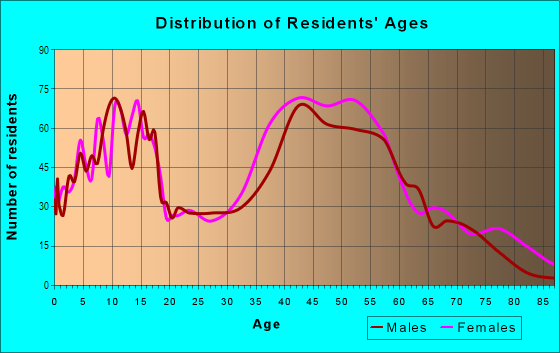
| Males: | 3,725 |
| Females: | 3,781 |
| Males: | 43.6 years |
| Females: | 44.0 years |
Average household size:
| Colonial Oaks: | 7.2 people |
| New Jersey: | 2.6 people |
Percentage of family households:
| Colonial Oaks: | 58.2% |
| New Jersey: | 47.0% |
| Here: | 75.1% |
| New Jersey: | 49.9% |
Percentage of married-couple families with children (among all households):
| Colonial Oaks: | 33.3% |
| New Jersey: | 51.5% |
Percentage of single-mother households (among all households):
| Colonial Oaks: | 1.7% |
| New Jersey: | 7.6% |
Percentage of never married males 15 years old and over:
Percentage of never married females 15 years old and over:
| Colonial Oaks: | 11.0% |
| New Jersey: | 18.2% |
Percentage of never married females 15 years old and over:
| Colonial Oaks: | 14.4% |
| New Jersey: | 16.6% |
Percentage of people that speak English not well or not at all:
| Colonial Oaks: | 4.2% |
| New Jersey: | 6.5% |
Percentage of people born in this state:
Percentage of people born in another U.S. state:
Percentage of native residents but born outside the U.S.:
Percentage of foreign born residents:
| Here: | 43.3% |
| New Jersey: | 50.7% |
Percentage of people born in another U.S. state:
| Colonial Oaks: | 26.5% |
| New Jersey: | 23.4% |
Percentage of native residents but born outside the U.S.:
| Here: | 0.9% |
| New Jersey: | 2.4% |
Percentage of foreign born residents:
| Here: | 29.3% |
| New Jersey: | 23.5% |
Owner-occupied
Renter-occupied

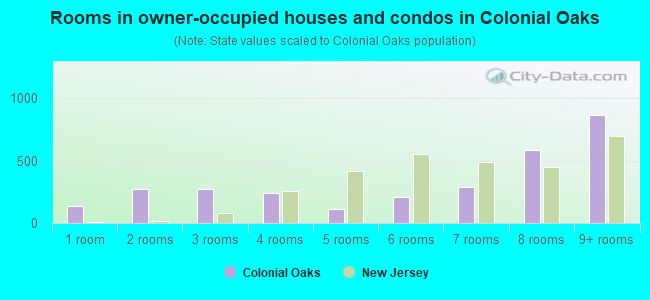
- Rooms in owner-occupied houses and condos in Colonial Oaks
- 1331 room
- 2732 rooms
- 2713 rooms
- 2414 rooms
- 1115 rooms
- 2126 rooms
- 2857 rooms
- 5898 rooms
- 8669+ rooms
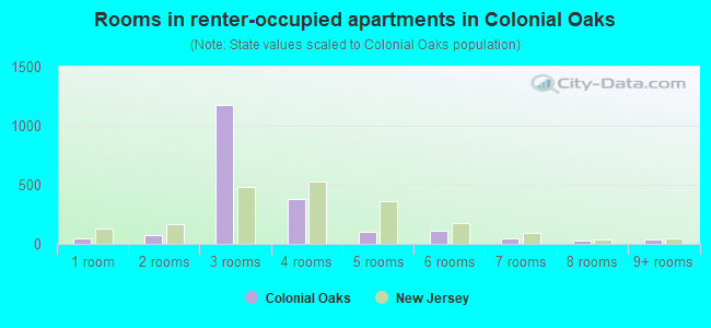
- Rooms in renter-occupied apartments in Colonial Oaks
- 491 room
- 782 rooms
- 1,1783 rooms
- 3814 rooms
- 985 rooms
- 1116 rooms
- 507 rooms
- 308 rooms
- 369+ rooms
Owner-occupied
Renter-occupied
- Bedrooms in owner-occupied houses and condos in Colonial Oaks
- 133no bedroom
- 1581 bedroom
- 8972 bedrooms
- 3023 bedrooms
- 1,1314 bedrooms
- 4235+ bedrooms
- Bedrooms in renter-occupied apartments in Colonial Oaks
- 73no bedroom
- 1,5751 bedroom
- 3602 bedrooms
- 753 bedrooms
- 324 bedrooms
- 65+ bedrooms
Average number of cars or other vehicles available in houses/condos:
Average number of cars or other vehicles available in apartments:
| This neighborhood: | 2.4 |
| New Jersey: | 2.0 |
Average number of cars or other vehicles available in apartments:
| Here: | |
| New Jersey: |
Percentage of units with a mortgage:
| Colonial Oaks: | 65.9% |
| New Jersey: | 63.3% |
Average estimated value of detached houses in 2022 (68.6% of all units):
| Colonial Oaks: | $698,770 |
| New Jersey: | $537,591 |
- Year house built in Colonial Oaks
- 02020 or later
- 912010 to 2019
- 2362000 to 2009
- 2151990 to 1999
- 4691980 to 1989
- 7491970 to 1979
- 8031960 to 1969
- 3051950 to 1959
- 1291940 to 1949
- 1251939 or earlier
City-data.com crime index for place in 2020 (higher means more crime):
| City: | 44.2 |
| U.S. average: | 219.5 |
Travel time to work (commute)
![Travel time to work (commute)]()
- 40Less than 5 minutes
- 975 to 9 minutes
- 21510 to 14 minutes
- 28815 to 19 minutes
- 37720 to 24 minutes
- 14825 to 29 minutes
- 42330 to 34 minutes
- 8635 to 39 minutes
- 21440 to 44 minutes
- 26345 to 59 minutes
- 31160 to 89 minutes
- 31290 or more minutes

Means of transportation to work
![Means of transportation to work]()
- 63.6%2,379Drove a car alone
- 4.1%155Carpooled
- 5.4%201Bus
- 0.5%19Subway or elevated rail
- 0.8%31Long-distance train or commuter rail
- 1.5%55Light rail, streetcar or trolley
- 0.7%27Taxi
- 1.7%63Walked
- 1.5%57Other means
- 25.6%956Worked at home

Time leaving home to go to work
![Time leaving home to go to work]()
- 3912:00 a.m. to 4:59 a.m.
- 635:00 a.m. to 5:29 a.m.
- 1355:30 a.m. to 5:59 a.m.
- 1566:00 a.m. to 6:29 a.m.
- 2026:30 a.m. to 6:59 a.m.
- 4517:00 a.m. to 7:29 a.m.
- 2447:30 a.m. to 7:59 a.m.
- 4998:00 a.m. to 8:29 a.m.
- 2838:30 a.m. to 8:59 a.m.
- 3309:00 a.m. to 9:59 a.m.
- 13010:00 a.m. to 10:59 a.m.
- 3711:00 a.m. to 11:59 a.m.
- 16212:00 p.m. to 3:59 p.m.
- 534:00 p.m. to 11:59 p.m.

Occupations of males:
- Percentage of males in management occupations (except farmers):
Here: 26.3% New Jersey: 13.9%
- Percentage of males in business and financial operations occupations:
Here: 11.8% New Jersey: 6.9%
- Percentage of males in computer and mathematical occupations:
Here: 9.7% New Jersey: 6.5%
- Percentage of males in architecture and engineering occupations:
Here: 3.7% New Jersey: 3.1%
- Percentage of males in life, physical, and social science occupations:
Here: 3.1% New Jersey: 1.2%
- Percentage of males in community and social services occupations:
Here: 1.7% New Jersey: 1.1%
- Percentage of males in legal occupations:
Here: 1.7% New Jersey: 1.5%
- Percentage of males in education, training, and library occupations:
Here: 3.4% New Jersey: 3.6%
- Percentage of males in arts, design, entertainment, sports, and media occupations:
Here: 2.7% New Jersey: 2.0%
- Percentage of males in healthcare practitioners and technical occupations:
Here: 4.3% New Jersey: 3.2%
- Percentage of males in service occupations:
Here: 6.5% New Jersey: 12.9%
- Percentage of males in sales and office occupations:
Here: 14.0% New Jersey: 15.3%
- Percentage of males in construction, extraction, and maintenance occupations:
Here: 1.8% New Jersey: 8.1%
- Percentage of males in production occupations:
Here: 1.1% New Jersey: 4.8%
- Percentage of males in transportation occupations:
Here: 4.4% New Jersey: 6.5%
Occupations of females:
- Percentage of females in management occupations (except farmers):
Here: 14.7% New Jersey: 10.4%
- Percentage of females in business and financial operations occupations:
Here: 9.6% New Jersey: 7.3%
- Percentage of females in computer and mathematical occupations:
Here: 5.6% New Jersey: 2.4%
- Percentage of females in life, physical, and social science occupations:
Here: 4.4% New Jersey: 1.4%
- Percentage of females in community and social services occupations:
Here: 3.8% New Jersey: 2.6%
- Percentage of females in education, training, and library occupations:
Here: 16.4% New Jersey: 11.4%
- Percentage of females in arts, design, entertainment, sports, and media occupations:
Here: 2.6% New Jersey: 2.2%
- Percentage of females in healthcare practitioners and technical occupations:
Here: 9.8% New Jersey: 9.6%
- Percentage of females in service occupations:
Here: 8.7% New Jersey: 17.2%
- Percentage of females in sales and office occupations:
Here: 19.4% New Jersey: 26.7%
- Percentage of females in production occupations:
Here: 4.0% New Jersey: 2.7%
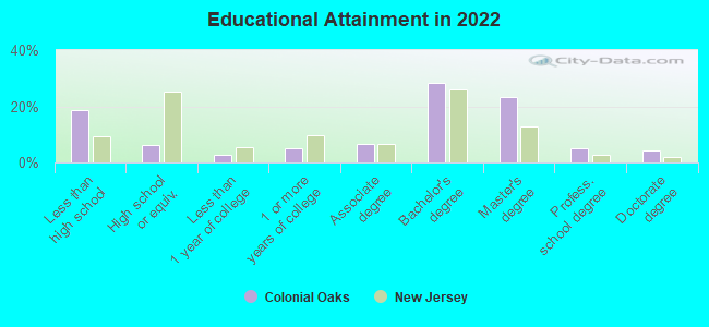
Education in this neighborhood (subdivision or community):
- Percentage of people 3 years and older in K-12 schools:
Colonial Oaks: 19.6% New Jersey: 16.6%
- Percentage of people 3 years and older in undergraduate colleges:
Colonial Oaks: 7.0% New Jersey: 4.9%
- Percentage of people 3 years and older in grad. or professional schools:
Colonial Oaks: 3.0% New Jersey: 1.6%
- Percentage of students K-12 enrolled in private schools:
Colonial Oaks: 29.3% New Jersey: 12.7%
Percentage of population below poverty level:
| Colonial Oaks: | 3.1% |
| New Jersey: | 9.7% |
Median year owner moved in (as recorded in 2022):
| Colonial Oaks: | 2006 |
| New Jersey: | 2008 |
Percentage of married-couple families with both working:
| Colonial Oaks: | 82.4% |
| New Jersey: | 72.0% |
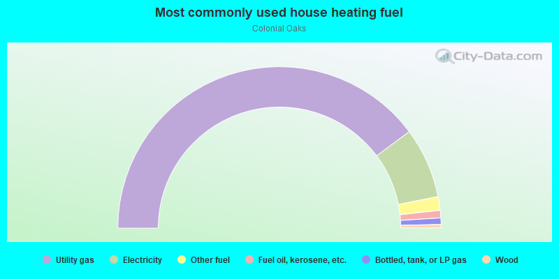
- 79.3%Utility gas
- 14.1%Electricity
- 2.7%Other fuel
- 1.5%Fuel oil, kerosene, etc.
- 1.3%Bottled, tank, or LP gas
- 0.7%Wood
Limited-access highways (interstate or state) in this neighborhood:
New Jersey Tpke (I- 95)
Length: 2.02 miles
Directions: N-S, SW-NE
Directions: N-S, SW-NE
Roads and streets:
Dunhams Corner Rd
Length: 2.08 miles
Directions: E-W, N-S, SW-NE
Address range: 181 to 361
Directions: E-W, N-S, SW-NE
Address range: 181 to 361
Co Rd 617 (Ryders Ln)
Length: 1.89 miles
Directions: E-W, N-S, SE-NW, SW-NE
Address range: 416 to 611
Directions: E-W, N-S, SE-NW, SW-NE
Address range: 416 to 611
Cranbury Rd
Length: 1.51 miles
Direction: SW-NE
Address range: 510 to 655
Direction: SW-NE
Address range: 510 to 655
Fern Rd
Length: 1.40 miles
Directions: E-W, N-S, SE-NW, SW-NE
Address range: 62 to 199
Directions: E-W, N-S, SE-NW, SW-NE
Address range: 62 to 199
Tall Oaks Dr
Length: 1.14 miles
Directions: E-W, N-S, SE-NW, SW-NE
Address range: 1 to 107
Directions: E-W, N-S, SE-NW, SW-NE
Address range: 1 to 107
Independence Dr
Length: 0.94 miles
Directions: E-W, N-S, SE-NW, SW-NE
Address range: 1 to 99
Directions: E-W, N-S, SE-NW, SW-NE
Address range: 1 to 99
Yorktown Rd
Length: 0.90 miles
Directions: E-W, N-S, SE-NW, SW-NE
Address range: 1 to 87
Directions: E-W, N-S, SE-NW, SW-NE
Address range: 1 to 87
Valley Forge Dr
Length: 0.83 miles
Directions: E-W, N-S, SE-NW, SW-NE
Address range: 1 to 86
Directions: E-W, N-S, SE-NW, SW-NE
Address range: 1 to 86
Dutch Rd
Length: 0.81 miles
Directions: E-W, N-S, SE-NW
Address range: 1 to 89
Directions: E-W, N-S, SE-NW
Address range: 1 to 89
Hardenburg Ln
Length: 0.73 miles
Directions: E-W, SE-NW
Address range: 1 to 70
Directions: E-W, SE-NW
Address range: 1 to 70
Peach Orchard Dr
Length: 0.68 miles
Directions: E-W, N-S, SE-NW, SW-NE
Address range: 2 to 63
Directions: E-W, N-S, SE-NW, SW-NE
Address range: 2 to 63
Jean Walling Civic Center Dr
Length: 0.58 miles
Directions: E-W, N-S, SE-NW, SW-NE
Directions: E-W, N-S, SE-NW, SW-NE
Hollis Rd
Length: 0.58 miles
Directions: E-W, N-S, SE-NW, SW-NE
Address range: 1 to 56
Directions: E-W, N-S, SE-NW, SW-NE
Address range: 1 to 56
Hartlander St
Length: 0.52 miles
Directions: E-W, N-S, SE-NW, SW-NE
Address range: 1 to 56
Directions: E-W, N-S, SE-NW, SW-NE
Address range: 1 to 56
Buckingham Dr
Length: 0.51 miles
Directions: N-S, SW-NE
Address range: 1 to 44
Directions: N-S, SW-NE
Address range: 1 to 44
Darby Rd
Length: 0.51 miles
Directions: E-W, N-S, SE-NW
Address range: 1 to 32
Directions: E-W, N-S, SE-NW
Address range: 1 to 32
Buckthorn Rd
Length: 0.50 miles
Directions: E-W, N-S, SE-NW, SW-NE
Directions: E-W, N-S, SE-NW, SW-NE
Glouster Ct
Length: 0.47 miles
Directions: E-W, N-S, SE-NW, SW-NE
Address range: 1 to 58
Directions: E-W, N-S, SE-NW, SW-NE
Address range: 1 to 58
Redcoat Dr
Length: 0.45 miles
Direction: E-W
Address range: 1 to 41
Direction: E-W
Address range: 1 to 41
Hershey Rd
Length: 0.43 miles
Directions: N-S, SE-NW, SW-NE
Address range: 1 to 58
Directions: N-S, SE-NW, SW-NE
Address range: 1 to 58
Boston Post Rd
Length: 0.42 miles
Directions: N-S, SE-NW, SW-NE
Address range: 1 to 48
Directions: N-S, SE-NW, SW-NE
Address range: 1 to 48
Milltown Rd (Co Rd 606)
Length: 0.41 miles
Directions: E-W, SE-NW
Address range: 272 to 343
Directions: E-W, SE-NW
Address range: 272 to 343
Gunpowder Dr
Length: 0.40 miles
Directions: E-W, N-S, SE-NW, SW-NE
Address range: 1 to 45
Directions: E-W, N-S, SE-NW, SW-NE
Address range: 1 to 45
Lantern Ln
Length: 0.39 miles
Directions: E-W, N-S, SE-NW
Address range: 1 to 17
Directions: E-W, N-S, SE-NW
Address range: 1 to 17
Beacon Hill Dr
Length: 0.38 miles
Directions: E-W, N-S, SE-NW, SW-NE
Address range: 1 to 47
Directions: E-W, N-S, SE-NW, SW-NE
Address range: 1 to 47
Colonial Dr
Length: 0.38 miles
Directions: N-S, SE-NW
Address range: 3 to 44
Directions: N-S, SE-NW
Address range: 3 to 44
Rues Ln
Length: 0.38 miles
Direction: E-W
Address range: 266 to 606
Direction: E-W
Address range: 266 to 606
Bunker Hill Run
Length: 0.37 miles
Directions: E-W, N-S, SE-NW
Address range: 1 to 42
Directions: E-W, N-S, SE-NW
Address range: 1 to 42
Thrush Dr
Length: 0.36 miles
Directions: E-W, N-S, SE-NW, SW-NE
Address range: 1 to 40
Directions: E-W, N-S, SE-NW, SW-NE
Address range: 1 to 40
Rebel Run Dr
Length: 0.35 miles
Directions: E-W, N-S, SE-NW, SW-NE
Address range: 1 to 43
Directions: E-W, N-S, SE-NW, SW-NE
Address range: 1 to 43
Alexander Rd
Length: 0.30 miles
Direction: N-S
Address range: 1 to 42
Direction: N-S
Address range: 1 to 42
Meadowlark Ln
Length: 0.30 miles
Directions: E-W, SE-NW, SW-NE
Address range: 1 to 33
Directions: E-W, SE-NW, SW-NE
Address range: 1 to 33
Surrey Ln
Length: 0.30 miles
Directions: E-W, N-S, SW-NE
Address range: 1 to 36
Directions: E-W, N-S, SW-NE
Address range: 1 to 36
Sagamore Ln
Length: 0.28 miles
Directions: E-W, N-S, SE-NW
Address range: 1 to 32
Directions: E-W, N-S, SE-NW
Address range: 1 to 32
Delaware Dr
Length: 0.27 miles
Directions: E-W, SW-NE
Address range: 1 to 29
Directions: E-W, SW-NE
Address range: 1 to 29
Putnam Rd
Length: 0.27 miles
Directions: E-W, N-S, SW-NE
Address range: 1 to 52
Directions: E-W, N-S, SW-NE
Address range: 1 to 52
Pilgrim Run
Length: 0.27 miles
Directions: N-S, SE-NW
Address range: 1 to 99
Directions: N-S, SE-NW
Address range: 1 to 99
Quaker Dr
Length: 0.26 miles
Directions: N-S, SE-NW, SW-NE
Address range: 1 to 34
Directions: N-S, SE-NW, SW-NE
Address range: 1 to 34
Candle Ln
Length: 0.26 miles
Directions: E-W, SW-NE
Address range: 1 to 34
Directions: E-W, SW-NE
Address range: 1 to 34
Burlington Ln
Length: 0.24 miles
Directions: E-W, SW-NE
Address range: 1 to 26
Directions: E-W, SW-NE
Address range: 1 to 26
Winchester Dr
Length: 0.24 miles
Directions: E-W, N-S
Address range: 1 to 22
Directions: E-W, N-S
Address range: 1 to 22
Guernsey Ln
Length: 0.24 miles
Directions: E-W, SW-NE
Address range: 1 to 27
Directions: E-W, SW-NE
Address range: 1 to 27
McGinnis St
Length: 0.24 miles
Directions: N-S, SE-NW
Address range: 1 to 19
Directions: N-S, SE-NW
Address range: 1 to 19
Springfield Rd
Length: 0.23 miles
Direction: SE-NW
Address range: 1 to 28
Direction: SE-NW
Address range: 1 to 28
Sussex Rd
Length: 0.23 miles
Directions: N-S, SE-NW
Address range: 1 to 32
Directions: N-S, SE-NW
Address range: 1 to 32
Hamilton Dr
Length: 0.23 miles
Directions: N-S, SE-NW
Address range: 1 to 99
Directions: N-S, SE-NW
Address range: 1 to 99
Grace Rd
Length: 0.22 miles
Directions: E-W, N-S, SE-NW
Address range: 1 to 26
Directions: E-W, N-S, SE-NW
Address range: 1 to 26
Brookside Ct
Length: 0.20 miles
Directions: E-W, N-S, SE-NW, SW-NE
Address range: 1 to 32
Directions: E-W, N-S, SE-NW, SW-NE
Address range: 1 to 32
Concord Dr
Length: 0.20 miles
Directions: E-W, SE-NW
Address range: 1 to 24
Directions: E-W, SE-NW
Address range: 1 to 24
Briar Ridge Rd
Length: 0.20 miles
Directions: N-S, SE-NW, SW-NE
Directions: N-S, SE-NW, SW-NE
Williamsburg Ct
Length: 0.19 miles
Directions: E-W, N-S, SE-NW, SW-NE
Address range: 1 to 30
Directions: E-W, N-S, SE-NW, SW-NE
Address range: 1 to 30
Smith Ln
Length: 0.19 miles
Direction: E-W
Address range: 1 to 32
Direction: E-W
Address range: 1 to 32
Woodlot Rd
Length: 0.19 miles
Directions: N-S, SE-NW
Address range: 1 to 28
Directions: N-S, SE-NW
Address range: 1 to 28
Plymouth Ln
Length: 0.19 miles
Directions: N-S, SE-NW
Address range: 1 to 26
Directions: N-S, SE-NW
Address range: 1 to 26
Vander Water Ct
Length: 0.18 miles
Directions: E-W, N-S, SW-NE
Address range: 1 to 29
Directions: E-W, N-S, SW-NE
Address range: 1 to 29
Prescott Rd
Length: 0.18 miles
Directions: N-S, SE-NW
Address range: 1 to 25
Directions: N-S, SE-NW
Address range: 1 to 25
Margie Rd
Length: 0.18 miles
Directions: E-W, N-S, SW-NE
Address range: 1 to 23
Directions: E-W, N-S, SW-NE
Address range: 1 to 23
Jason Dr
Length: 0.18 miles
Directions: E-W, N-S, SE-NW, SW-NE
Address range: 8 to 14
Directions: E-W, N-S, SE-NW, SW-NE
Address range: 8 to 14
Puritan Rd
Length: 0.17 miles
Direction: E-W
Address range: 1 to 23
Direction: E-W
Address range: 1 to 23
Stage Coach Run
Length: 0.17 miles
Directions: E-W, N-S, SW-NE
Address range: 1 to 99
Directions: E-W, N-S, SW-NE
Address range: 1 to 99
Cornwall Dr
Length: 0.17 miles
Direction: SE-NW
Address range: 1 to 5
Direction: SE-NW
Address range: 1 to 5
Braddock St
Length: 0.17 miles
Direction: E-W
Address range: 1 to 23
Direction: E-W
Address range: 1 to 23
Currier Rd
Length: 0.17 miles
Directions: E-W, SE-NW
Address range: 1 to 20
Directions: E-W, SE-NW
Address range: 1 to 20
New Dover Rd
Length: 0.16 miles
Directions: E-W, SW-NE
Address range: 3 to 32
Directions: E-W, SW-NE
Address range: 3 to 32
Constitution Ct
Length: 0.16 miles
Directions: E-W, N-S, SW-NE
Address range: 1 to 28
Directions: E-W, N-S, SW-NE
Address range: 1 to 28
Co Rd 694 (Church Ln)
Length: 0.15 miles
Directions: E-W, N-S, SE-NW, SW-NE
Directions: E-W, N-S, SE-NW, SW-NE
Van Hise Ct
Length: 0.15 miles
Direction: E-W
Address range: 1 to 32
Direction: E-W
Address range: 1 to 32
Eldridge Dr
Length: 0.15 miles
Directions: E-W, N-S, SE-NW, SW-NE
Address range: 1 to 99
Directions: E-W, N-S, SE-NW, SW-NE
Address range: 1 to 99
Matthew Manor
Length: 0.14 miles
Direction: SW-NE
Address range: 1 to 10
Direction: SW-NE
Address range: 1 to 10
Bennington Ct
Length: 0.14 miles
Direction: SW-NE
Address range: 1 to 24
Direction: SW-NE
Address range: 1 to 24
Melanie Manor
Length: 0.14 miles
Directions: E-W, N-S, SE-NW, SW-NE
Address range: 78 to 99
Directions: E-W, N-S, SE-NW, SW-NE
Address range: 78 to 99
Mayfair Ct
Length: 0.14 miles
Directions: N-S, SE-NW, SW-NE
Address range: 1 to 23
Directions: N-S, SE-NW, SW-NE
Address range: 1 to 23
Brandywine Dr
Length: 0.13 miles
Direction: E-W
Address range: 1 to 16
Direction: E-W
Address range: 1 to 16
Liberty Bell Ct
Length: 0.12 miles
Directions: E-W, N-S, SE-NW
Address range: 1 to 24
Directions: E-W, N-S, SE-NW
Address range: 1 to 24
Nenninger Ln
Length: 0.12 miles
Directions: N-S, SW-NE
Address range: 1 to 14
Directions: N-S, SW-NE
Address range: 1 to 14
Leighton Dr (Leighton Ct)
Length: 0.12 miles
Direction: E-W
Address range: 1 to 12
Direction: E-W
Address range: 1 to 12
Bristol Ct
Length: 0.12 miles
Directions: E-W, SE-NW
Address range: 1 to 23
Directions: E-W, SE-NW
Address range: 1 to 23
Mount Ct
Length: 0.12 miles
Direction: SW-NE
Address range: 1 to 18
Direction: SW-NE
Address range: 1 to 18
Falcon Rd
Length: 0.12 miles
Directions: N-S, SW-NE
Address range: 1 to 20
Directions: N-S, SW-NE
Address range: 1 to 20
Stockton Ct
Length: 0.11 miles
Directions: N-S, SE-NW, SW-NE
Address range: 1 to 25
Directions: N-S, SE-NW, SW-NE
Address range: 1 to 25
Saratoga Ct
Length: 0.11 miles
Direction: SE-NW
Address range: 1 to 23
Direction: SE-NW
Address range: 1 to 23
Troy Ct
Length: 0.11 miles
Direction: SW-NE
Address range: 1 to 22
Direction: SW-NE
Address range: 1 to 22
Barkley Ct
Length: 0.11 miles
Directions: N-S, SE-NW, SW-NE
Address range: 1 to 25
Directions: N-S, SE-NW, SW-NE
Address range: 1 to 25
Federal Rd
Length: 0.11 miles
Direction: E-W
Address range: 1 to 16
Direction: E-W
Address range: 1 to 16
Morristown Dr
Length: 0.11 miles
Direction: E-W
Address range: 1 to 14
Direction: E-W
Address range: 1 to 14
Dogwood Ct
Length: 0.11 miles
Direction: N-S
Address range: 1 to 24
Direction: N-S
Address range: 1 to 24
Eileen Ct
Length: 0.11 miles
Directions: E-W, SW-NE
Address range: 1 to 21
Directions: E-W, SW-NE
Address range: 1 to 21
Warwick Rd
Length: 0.11 miles
Directions: E-W, SE-NW
Address range: 1 to 20
Directions: E-W, SE-NW
Address range: 1 to 20
Pennsylvania Dr
Length: 0.10 miles
Direction: SW-NE
Direction: SW-NE
Deseret Dr
Length: 0.10 miles
Direction: E-W
Address range: 1 to 14
Direction: E-W
Address range: 1 to 14
Cape Ct
Length: 0.10 miles
Direction: E-W
Address range: 1 to 20
Direction: E-W
Address range: 1 to 20
Persimmon Ct
Length: 0.10 miles
Direction: E-W
Address range: 1 to 16
Direction: E-W
Address range: 1 to 16
Mundy Rd
Length: 0.10 miles
Directions: E-W, N-S, SE-NW
Address range: 1 to 21
Directions: E-W, N-S, SE-NW
Address range: 1 to 21
Raven Ct
Length: 0.09 miles
Directions: E-W, SE-NW
Address range: 1 to 21
Directions: E-W, SE-NW
Address range: 1 to 21
Aspen Ct
Length: 0.09 miles
Direction: E-W
Address range: 1 to 99
Direction: E-W
Address range: 1 to 99
Schindler Ct
Length: 0.08 miles
Direction: E-W
Address range: 1 to 20
Direction: E-W
Address range: 1 to 20
Winterberry Ct
Length: 0.08 miles
Directions: E-W, N-S, SE-NW, SW-NE
Address range: 16 to 98
Directions: E-W, N-S, SE-NW, SW-NE
Address range: 16 to 98
Carlton Ct
Length: 0.08 miles
Direction: SW-NE
Address range: 1 to 19
Direction: SW-NE
Address range: 1 to 19
Magnolia Ct
Length: 0.08 miles
Directions: E-W, N-S, SE-NW, SW-NE
Directions: E-W, N-S, SE-NW, SW-NE
Congress Ave
Length: 0.08 miles
Direction: SE-NW
Direction: SE-NW
Hager St
Length: 0.08 miles
Directions: E-W, SE-NW
Address range: 1 to 9
Directions: E-W, SE-NW
Address range: 1 to 9
Firethorn Ct
Length: 0.07 miles
Directions: E-W, N-S, SE-NW, SW-NE
Address range: 1 to 99
Directions: E-W, N-S, SE-NW, SW-NE
Address range: 1 to 99
Robin Ct
Length: 0.07 miles
Direction: N-S
Address range: 1 to 16
Direction: N-S
Address range: 1 to 16
Jamestown Ct
Length: 0.06 miles
Direction: SE-NW
Address range: 1 to 17
Direction: SE-NW
Address range: 1 to 17
Hawthorne Ct
Length: 0.06 miles
Directions: E-W, N-S, SE-NW, SW-NE
Directions: E-W, N-S, SE-NW, SW-NE
Patriot Ct
Length: 0.06 miles
Direction: E-W
Address range: 1 to 18
Direction: E-W
Address range: 1 to 18
Periwinkle Ct
Length: 0.06 miles
Directions: E-W, N-S, SE-NW, SW-NE
Directions: E-W, N-S, SE-NW, SW-NE
Brier Hill Ct
Length: 0.06 miles
Direction: SW-NE
Direction: SW-NE
Fernwood Ct
Length: 0.06 miles
Direction: SE-NW
Address range: 1 to 23
Direction: SE-NW
Address range: 1 to 23
Dorset Ct
Length: 0.05 miles
Direction: SW-NE
Address range: 1 to 17
Direction: SW-NE
Address range: 1 to 17
Morris Ct
Length: 0.05 miles
Directions: E-W, SW-NE
Address range: 2 to 36
Directions: E-W, SW-NE
Address range: 2 to 36
Redberry Ct
Length: 0.05 miles
Directions: E-W, N-S, SE-NW, SW-NE
Directions: E-W, N-S, SE-NW, SW-NE
Snowbell Ct
Length: 0.05 miles
Directions: E-W, N-S, SE-NW, SW-NE
Address range: 22 to 98
Directions: E-W, N-S, SE-NW, SW-NE
Address range: 22 to 98
Honeysuckle Ct
Length: 0.05 miles
Directions: E-W, N-S, SE-NW, SW-NE
Address range: 1 to 99
Directions: E-W, N-S, SE-NW, SW-NE
Address range: 1 to 99
Viburnum Ct
Length: 0.05 miles
Directions: E-W, N-S, SE-NW, SW-NE
Directions: E-W, N-S, SE-NW, SW-NE
Bayberry Ct
Length: 0.05 miles
Directions: E-W, N-S, SE-NW, SW-NE
Directions: E-W, N-S, SE-NW, SW-NE
Cornwall Ct
Length: 0.04 miles
Direction: SW-NE
Address range: 1 to 99
Direction: SW-NE
Address range: 1 to 99
Heritage Ct
Length: 0.04 miles
Direction: N-S
Address range: 1 to 15
Direction: N-S
Address range: 1 to 15
Henley Dr
Length: 0.04 miles
Direction: SE-NW
Direction: SE-NW
Bedford Ct
Length: 0.04 miles
Direction: SW-NE
Address range: 1 to 16
Direction: SW-NE
Address range: 1 to 16
Coachman Ct
Length: 0.04 miles
Direction: E-W
Address range: 1 to 16
Direction: E-W
Address range: 1 to 16
Azalea Ct
Length: 0.04 miles
Directions: E-W, N-S, SE-NW, SW-NE
Directions: E-W, N-S, SE-NW, SW-NE
Betsy Ross Ct
Length: 0.04 miles
Direction: N-S
Direction: N-S
Lefferts Ct
Length: 0.04 miles
Direction: N-S
Direction: N-S
Old Tennent Ct
Length: 0.04 miles
Direction: N-S
Direction: N-S
Minute Man Ct
Length: 0.04 miles
Direction: SE-NW
Address range: 1 to 14
Direction: SE-NW
Address range: 1 to 14
Barns Ct
Length: 0.04 miles
Direction: N-S
Address range: 1 to 17
Direction: N-S
Address range: 1 to 17
Revere Ct
Length: 0.03 miles
Direction: SE-NW
Address range: 1 to 14
Direction: SE-NW
Address range: 1 to 14
Cris Ct
Length: 0.03 miles
Direction: SE-NW
Address range: 1 to 14
Direction: SE-NW
Address range: 1 to 14
Perrine Ct
Length: 0.03 miles
Direction: N-S
Address range: 1 to 12
Direction: N-S
Address range: 1 to 12
Bissett Ct
Length: 0.03 miles
Direction: SW-NE
Address range: 1 to 5
Direction: SW-NE
Address range: 1 to 5
Swallow Ct
Length: 0.02 miles
Directions: E-W, N-S, SE-NW, SW-NE
Address range: 1 to 15
Directions: E-W, N-S, SE-NW, SW-NE
Address range: 1 to 15
Other features:
Irelands Brk
Length: 1.11 miles
Directions: E-W, SW-NE
Directions: E-W, SW-NE
Beaverdam Brk
Length: 0.87 miles
Directions: E-W, SE-NW, SW-NE
Directions: E-W, SE-NW, SW-NE
Other features:
Drainage Ditch
Length: 0.31 miles
Directions: E-W, SE-NW
Directions: E-W, SE-NW