Central Street (Central Street Neighbors Association) neighborhood in Evanston, Illinois (IL), 60201 detailed profile
Settings
X


Business Search - 14 Million verified businesses
Area: 2.432 square miles
Population: 15,828
Population density:
| Central Street (Central Street Neighbors Association): | 6,507 people per square mile |
| Evanston: | 9,752 people per square mile |

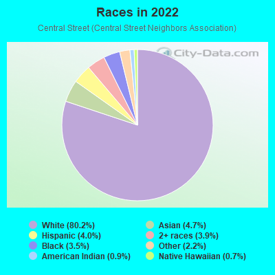
- 13,32180.2%White
- 7864.7%Asian
- 6614.0%Hispanic or Latino
- 6423.9%Two or more races
- 5753.5%Black
- 3592.2%Some other race
- 1560.9%American Indian
- 1180.7%Native Hawaiian and Other
Pacific Islander
Distribution of median household income
![Distribution of median household income]()
- 295Less than $10,000
- 695$10,000 to $19,999
- 301$20,000 to $29,999
- 482$30,000 to $39,999
- 550$40,000 to $49,999
- 329$50,000 to $59,999
- 727$60,000 to $74,999
- 493$75,000 to $99,999
- 625$100,000 to $124,999
- 374$125,000 to $149,999
- 739$150,000 to $199,999
- 2,664$200,000 or more

Distribution of owner-occupied house/condo value
![Distribution of owner-occupied house/condo value]()
- 551Less than $50,000
- 768$50,000 to $99,999
- 332$100,000 to $149,999
- 410$150,000 to $199,999
- 226$200,000 to $249,999
- 149$250,000 to $299,999
- 415$300,000 to $399,999
- 613$400,000 to $499,999
- 1,324$500,000 to $749,999
- 1,299$750,000 to $999,999
- 1,343$1,000,000 or more

Distribution of rent paid by renters
![Distribution of rent paid by renters]()
- 52Less than $100
- 413$100 to $199
- 1,154$200 to $299
- 861$300 to $399
- 262$400 to $499
- 933$500 to $599
- 256$600 to $699
- 99$700 to $799
- 104$800 to $899
- 422$900 to $999
- 539$1,000 to $1,249
- 710$1,250 to $1,499
- 305$1,500 to $1,999
- 1,705$2,000 or more

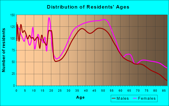
| Males: | 7,776 |
| Females: | 8,051 |
Males:
| This neighborhood: | 41.1 years |
| Whole city: | 39.6 years |
| This neighborhood: | 47.4 years |
| Whole city: | 42.5 years |
Average household size:
| Central Street (Central Street Neighbors Association): | 4.0 people |
| Evanston: | 27.0 people |
Percentage of family households:
| Central Street (Central Street Neighbors Association): | 41.1% |
| Evanston: | 36.2% |
| Here: | 53.0% |
| Evanston: | 36.9% |
Percentage of married-couple families with children (among all households):
| Central Street (Central Street Neighbors Association): | 37.2% |
| Evanston: | 31.7% |
Percentage of single-mother households (among all households):
| Central Street (Central Street Neighbors Association): | 4.3% |
| Evanston: | 9.5% |
Percentage of never married males 15 years old and over:
Percentage of never married females 15 years old and over:
| Central Street (Central Street Neighbors Association): | 12.4% |
| Evanston: | 20.0% |
Percentage of never married females 15 years old and over:
| Central Street (Central Street Neighbors Association): | 12.8% |
| city: | 24.1% |
Percentage of people that speak English not well or not at all:
| Central Street (Central Street Neighbors Association): | 0.6% |
| Evanston: | 1.2% |
Percentage of people born in this state:
Percentage of people born in another U.S. state:
Percentage of native residents but born outside the U.S.:
Percentage of foreign born residents:
| Here: | 51.4% |
| Evanston: | 48.3% |
Percentage of people born in another U.S. state:
| Central Street (Central Street Neighbors Association): | 37.3% |
| Evanston: | 35.9% |
Percentage of native residents but born outside the U.S.:
| Here: | 1.4% |
| city: | 2.0% |
Percentage of foreign born residents:
| Here: | 9.9% |
| Evanston: | 13.8% |
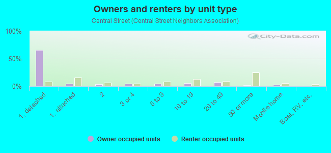
Owner-occupied
Renter-occupied

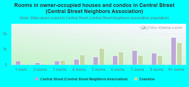
- Rooms in owner-occupied houses and condos in Central Street <
> - 2401 room
- 1322 rooms
- 2493 rooms
- 3594 rooms
- 5065 rooms
- 5766 rooms
- 9177 rooms
- 7488 rooms
- 1,7499+ rooms
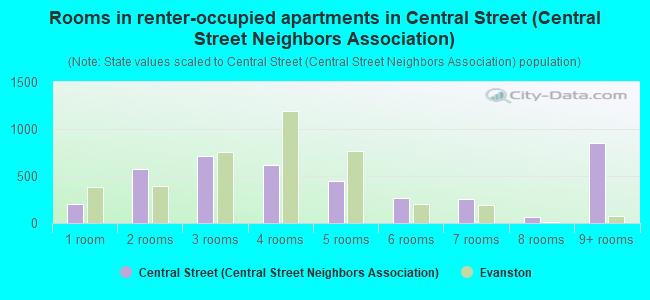
- Rooms in renter-occupied apartments in Central Street <
> - 2011 room
- 5702 rooms
- 7093 rooms
- 6204 rooms
- 4525 rooms
- 2626 rooms
- 2567 rooms
- 668 rooms
- 8539+ rooms
Owner-occupied
Renter-occupied
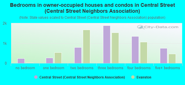
- Bedrooms in owner-occupied houses and condos in Central Street <
> - 240no bedroom
- 2721 bedroom
- 7922 bedrooms
- 1,8933 bedrooms
- 1,3544 bedrooms
- 7485+ bedrooms
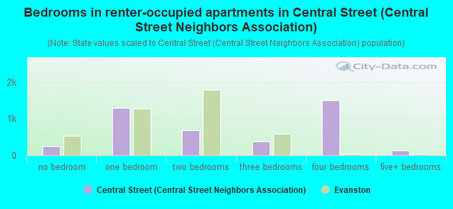
- Bedrooms in renter-occupied apartments in Central Street <
> - 247no bedroom
- 1,2921 bedroom
- 6802 bedrooms
- 3883 bedrooms
- 1,4974 bedrooms
- 1375+ bedrooms
Average number of cars or other vehicles available in houses/condos:
Average number of cars or other vehicles available in apartments:
| This neighborhood: | 1.5 |
| Evanston: | 1.5 |
Average number of cars or other vehicles available in apartments:
| Here: | |
| city: |
Percentage of units with a mortgage:
| Central Street (Central Street Neighbors Association): | 62.5% |
| Evanston: | 66.0% |
Average estimated value of detached houses in 2022 (58.0% of all units):
| Central Street (Central Street Neighbors Association): | $931,561 |
| Evanston: | $655,275 |
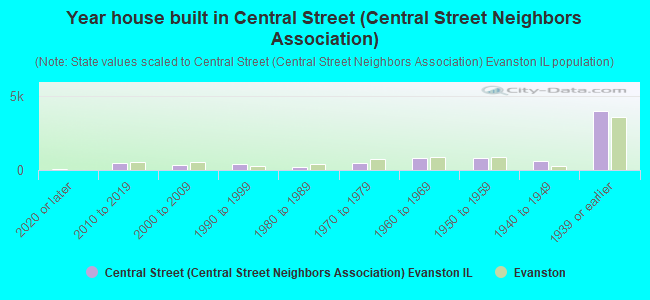
- Year house built in Central Street <
> - 1012020 or later
- 4572010 to 2019
- 3252000 to 2009
- 3821990 to 1999
- 2311980 to 1989
- 4601970 to 1979
- 7861960 to 1969
- 8201950 to 1959
- 5741940 to 1949
- 3,9531939 or earlier
City-data.com crime index for city in 2020 (higher means more crime):
| City: | 130.2 |
| U.S. average: | 219.5 |
Travel time to work (commute)
![Travel time to work (commute)]()
- 132Less than 5 minutes
- 5615 to 9 minutes
- 93910 to 14 minutes
- 69915 to 19 minutes
- 38920 to 24 minutes
- 22625 to 29 minutes
- 49630 to 34 minutes
- 14135 to 39 minutes
- 26940 to 44 minutes
- 94745 to 59 minutes
- 65860 to 89 minutes
- 6290 or more minutes

Means of transportation to work
![Means of transportation to work]()
- 41.4%3,221Drove a car alone
- 4.1%321Carpooled
- 4.3%331Bus
- 4.5%352Subway or elevated rail
- 9.9%769Long-distance train or commuter rail
- 1.2%93Light rail, streetcar or trolley
- 3.3%260Taxi
- 2.5%193Bicycle
- 6.5%509Walked
- 1.7%132Other means
- 30.7%2,384Worked at home

Time leaving home to go to work
![Time leaving home to go to work]()
- 9612:00 a.m. to 4:59 a.m.
- 365:00 a.m. to 5:29 a.m.
- 1075:30 a.m. to 5:59 a.m.
- 1976:00 a.m. to 6:29 a.m.
- 5036:30 a.m. to 6:59 a.m.
- 7577:00 a.m. to 7:29 a.m.
- 8667:30 a.m. to 7:59 a.m.
- 9828:00 a.m. to 8:29 a.m.
- 6798:30 a.m. to 8:59 a.m.
- 6809:00 a.m. to 9:59 a.m.
- 14710:00 a.m. to 10:59 a.m.
- 10811:00 a.m. to 11:59 a.m.
- 20712:00 p.m. to 3:59 p.m.
- 1734:00 p.m. to 11:59 p.m.

Occupations of males:
- Percentage of males in management occupations (except farmers):
Here: 24.7% city: 15.8%
- Percentage of males in business and financial operations occupations:
Here: 9.3% city: 8.9%
- Percentage of males in computer and mathematical occupations:
Here: 6.7% city: 8.5%
- Percentage of males in architecture and engineering occupations:
Here: 3.3% city: 2.9%
- Percentage of males in life, physical, and social science occupations:
Here: 3.2% city: 4.5%
- Percentage of males in community and social services occupations:
Here: 1.2% city: 1.6%
- Percentage of males in legal occupations:
Here: 7.3% city: 3.9%
- Percentage of males in education, training, and library occupations:
Here: 10.1% city: 11.6%
- Percentage of males in arts, design, entertainment, sports, and media occupations:
Here: 7.0% city: 4.3%
- Percentage of males in healthcare practitioners and technical occupations:
Here: 2.4% city: 2.5%
- Percentage of males in service occupations:
Here: 7.8% city: 10.6%
- Percentage of males in sales and office occupations:
Here: 12.5% city: 13.0%
- Percentage of males in construction, extraction, and maintenance occupations:
Here: 1.9% city: 2.0%
Occupations of females:
- Percentage of females in management occupations (except farmers):
Here: 15.9% city: 13.2%
- Percentage of females in business and financial operations occupations:
Here: 9.3% city: 8.2%
- Percentage of females in computer and mathematical occupations:
Here: 2.4% city: 3.3%
- Percentage of females in architecture and engineering occupations:
Here: 2.1% city: 1.1%
- Percentage of females in life, physical, and social science occupations:
Here: 3.8% city: 3.2%
- Percentage of females in community and social services occupations:
Here: 3.7% city: 3.4%
- Percentage of females in legal occupations:
Here: 4.2% city: 1.9%
- Percentage of females in education, training, and library occupations:
Here: 15.4% city: 15.2%
- Percentage of females in arts, design, entertainment, sports, and media occupations:
Here: 6.4% city: 5.3%
- Percentage of females in healthcare practitioners and technical occupations:
Here: 10.2% city: 8.9%
- Percentage of females in service occupations:
Here: 10.0% city: 16.3%
- Percentage of females in sales and office occupations:
Here: 15.7% city: 17.8%
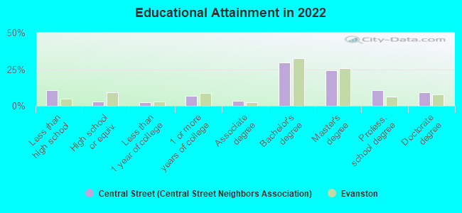
Education in this neighborhood (subdivision or community):
- Percentage of people 3 years and older in K-12 schools:
Central Street (Central Street Neighbors Association): 20.4% Evanston: 14.3%
- Percentage of people 3 years and older in undergraduate colleges:
Central Street (Central Street Neighbors Association): 7.6% Evanston: 11.6%
- Percentage of people 3 years and older in grad. or professional schools:
Central Street (Central Street Neighbors Association): 2.9% Evanston: 5.1%
- Percentage of students K-12 enrolled in private schools:
Central Street (Central Street Neighbors Association): 42.2% Evanston: 17.2%
Percentage of population below poverty level:
| Central Street (Central Street Neighbors Association): | 6.2% |
| Evanston: | 10.3% |
Median year owner moved in (as recorded in 2022):
| Central Street (Central Street Neighbors Association): | 2005 |
| Evanston: | 2010 |
Percentage of married-couple families with both working:
| Central Street (Central Street Neighbors Association): | 88.0% |
| Evanston: | 78.6% |
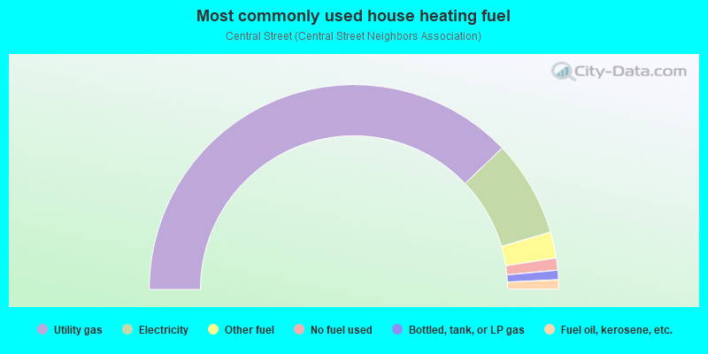
- 75.7%Utility gas
- 15.2%Electricity
- 4.1%Other fuel
- 1.9%No fuel used
- 1.5%Bottled, tank, or LP gas
- 1.5%Fuel oil, kerosene, etc.
Highways in this neighborhood:
Golf Rd
Length: 1.29 miles
Directions: E-W, SE-NW, SW-NE
Address range: 2500 to 3935
Directions: E-W, SE-NW, SW-NE
Address range: 2500 to 3935
Roads and streets:
Central St
Length: 3.76 miles
Direction: E-W
Address range: 600 to 3662
Direction: E-W
Address range: 600 to 3662
Colfax St
Length: 2.94 miles
Directions: E-W, SW-NE
Address range: 600 to 3363
Directions: E-W, SW-NE
Address range: 600 to 3363
Lincoln St
Length: 2.84 miles
Directions: E-W, SE-NW
Address range: 500 to 2999
Directions: E-W, SE-NW
Address range: 500 to 2999
Grant St
Length: 2.22 miles
Direction: E-W
Address range: 1600 to 3363
Direction: E-W
Address range: 1600 to 3363
Harrison St
Length: 2.08 miles
Directions: E-W, SW-NE
Address range: 1700 to 3399
Directions: E-W, SW-NE
Address range: 1700 to 3399
Hartzell St
Length: 1.62 miles
Directions: E-W, SE-NW
Address range: 2200 to 3398
Directions: E-W, SE-NW
Address range: 2200 to 3398
Park Pl
Length: 1.60 miles
Direction: E-W
Address range: 2300 to 3465
Direction: E-W
Address range: 2300 to 3465
Thayer St
Length: 1.47 miles
Directions: E-W, SE-NW, SW-NE
Address range: 2300 to 3699
Directions: E-W, SE-NW, SW-NE
Address range: 2300 to 3699
Payne St
Length: 1.38 miles
Direction: E-W
Address range: 2100 to 3399
Direction: E-W
Address range: 2100 to 3399
McCormick Blvd
Length: 1.11 miles
Direction: SW-NE
Address range: 1600 to 2599
Direction: SW-NE
Address range: 1600 to 2599
Mc Daniel Ave
Length: 1.10 miles
Directions: N-S, SW-NE
Address range: 1900 to 2764
Directions: N-S, SW-NE
Address range: 1900 to 2764
Sheridan Rd
Length: 1.06 miles
Directions: E-W, N-S, SE-NW
Address range: 301 to 2999
Directions: E-W, N-S, SE-NW
Address range: 301 to 2999
Noyes St
Length: 1.06 miles
Direction: E-W
Address range: 1900 to 3363
Direction: E-W
Address range: 1900 to 3363
Ewing Ave
Length: 0.98 miles
Direction: N-S
Address range: 2018 to 2763
Direction: N-S
Address range: 2018 to 2763
Lawndale Ave
Length: 0.94 miles
Direction: N-S
Address range: 2300 to 2799
Direction: N-S
Address range: 2300 to 2799
Bennett Ave
Length: 0.92 miles
Directions: N-S, SW-NE
Address range: 1900 to 2763
Directions: N-S, SW-NE
Address range: 1900 to 2763
Prairie Ave
Length: 0.90 miles
Direction: SE-NW
Address range: 2300 to 2799
Direction: SE-NW
Address range: 2300 to 2799
Lincolnwood Dr
Length: 0.88 miles
Directions: E-W, N-S, SW-NE
Address range: 2100 to 2732
Directions: E-W, N-S, SW-NE
Address range: 2100 to 2732
Central Park Ave
Length: 0.83 miles
Directions: N-S, SE-NW, SW-NE
Address range: 2100 to 2717
Directions: N-S, SE-NW, SW-NE
Address range: 2100 to 2717
Isabella St
Length: 0.78 miles
Directions: E-W, SE-NW, SW-NE
Address range: 200 to 3499
Directions: E-W, SE-NW, SW-NE
Address range: 200 to 3499
Green Bay Rd
Length: 0.77 miles
Direction: SE-NW
Address range: 2300 to 2734
Direction: SE-NW
Address range: 2300 to 2734
Simpson St
Length: 0.77 miles
Directions: E-W, SW-NE
Address range: 2200 to 2947
Directions: E-W, SW-NE
Address range: 2200 to 2947
Prospect Ave
Length: 0.75 miles
Direction: N-S
Address range: 2100 to 2699
Direction: N-S
Address range: 2100 to 2699
Jenks St
Length: 0.73 miles
Directions: E-W, SE-NW, SW-NE
Address range: 1300 to 2299
Directions: E-W, SE-NW, SW-NE
Address range: 1300 to 2299
Poplar Ave
Length: 0.67 miles
Directions: N-S, SE-NW
Address range: 2300 to 2748
Directions: N-S, SE-NW
Address range: 2300 to 2748
Livingston St
Length: 0.65 miles
Directions: E-W, SW-NE
Address range: 1300 to 2199
Directions: E-W, SW-NE
Address range: 1300 to 2199
Pioneer Rd
Length: 0.64 miles
Directions: E-W, N-S, SW-NE
Address range: 2100 to 2599
Directions: E-W, N-S, SW-NE
Address range: 2100 to 2599
Milburn St
Length: 0.60 miles
Direction: E-W
Address range: 500 to 899
Direction: E-W
Address range: 500 to 899
Ridge Ave
Length: 0.58 miles
Directions: N-S, SW-NE
Address range: 2328 to 2799
Directions: N-S, SW-NE
Address range: 2328 to 2799
Calvin Cir
Length: 0.56 miles
Directions: E-W, N-S, SE-NW, SW-NE
Address range: 1 to 80
Directions: E-W, N-S, SE-NW, SW-NE
Address range: 1 to 80
Hartrey Ave
Length: 0.56 miles
Direction: N-S
Address range: 2100 to 2599
Direction: N-S
Address range: 2100 to 2599
Gross Point Rd
Length: 0.48 miles
Direction: SW-NE
Address range: 2500 to 2715
Direction: SW-NE
Address range: 2500 to 2715
Asbury Ave
Length: 0.46 miles
Direction: N-S
Address range: 2400 to 2799
Direction: N-S
Address range: 2400 to 2799
Orrington Ave
Length: 0.45 miles
Directions: N-S, SW-NE
Address range: 2338 to 2699
Directions: N-S, SW-NE
Address range: 2338 to 2699
Trinity Ct
Length: 0.45 miles
Directions: E-W, N-S, SE-NW, SW-NE
Address range: 100 to 799
Directions: E-W, N-S, SE-NW, SW-NE
Address range: 100 to 799
Crawford Ave (N Crawford Ave)
Length: 0.43 miles
Directions: N-S, SE-NW
Address range: 2500 to 2737
Directions: N-S, SE-NW
Address range: 2500 to 2737
Ingleside Pl
Length: 0.41 miles
Direction: E-W
Address range: 500 to 899
Direction: E-W
Address range: 500 to 899
Cowper Ave
Length: 0.39 miles
Direction: N-S
Address range: 2300 to 2599
Direction: N-S
Address range: 2300 to 2599
Girard Ave
Length: 0.39 miles
Directions: N-S, SW-NE
Address range: 2801 to 2821
Directions: N-S, SW-NE
Address range: 2801 to 2821
Hastings Ave
Length: 0.39 miles
Direction: N-S
Address range: 2300 to 2599
Direction: N-S
Address range: 2300 to 2599
Ridgeway Ave
Length: 0.39 miles
Direction: N-S
Address range: 2300 to 2599
Direction: N-S
Address range: 2300 to 2599
Chancellor St
Length: 0.38 miles
Direction: E-W
Address range: 1200 to 1899
Direction: E-W
Address range: 1200 to 1899
Marcy Ave
Length: 0.38 miles
Direction: N-S
Address range: 2300 to 2599
Direction: N-S
Address range: 2300 to 2599
Clinton Pl
Length: 0.38 miles
Direction: E-W
Address range: 600 to 899
Direction: E-W
Address range: 600 to 899
Princeton Ave
Length: 0.38 miles
Direction: N-S
Address range: 2500 to 2799
Direction: N-S
Address range: 2500 to 2799
Eastwood Ave
Length: 0.38 miles
Direction: N-S
Address range: 2400 to 2735
Direction: N-S
Address range: 2400 to 2735
Forestview Rd
Length: 0.37 miles
Direction: N-S
Address range: 2100 to 2399
Direction: N-S
Address range: 2100 to 2399
Brown Ave
Length: 0.34 miles
Direction: N-S
Address range: 2100 to 2499
Direction: N-S
Address range: 2100 to 2499
Broadway Ave
Length: 0.31 miles
Direction: N-S
Address range: 2600 to 2799
Direction: N-S
Address range: 2600 to 2799
Walnut Ave
Length: 0.30 miles
Directions: N-S, SW-NE
Address range: 2600 to 2799
Directions: N-S, SW-NE
Address range: 2600 to 2799
Ashland Ave
Length: 0.30 miles
Direction: N-S
Address range: 2300 to 2641
Direction: N-S
Address range: 2300 to 2641
Sheridan Pl
Length: 0.29 miles
Directions: E-W, N-S, SE-NW
Address range: 2800 to 2899
Directions: E-W, N-S, SE-NW
Address range: 2800 to 2899
Hurd Ave
Length: 0.29 miles
Direction: N-S
Address range: 2500 to 2750
Direction: N-S
Address range: 2500 to 2750
Bryant Ave
Length: 0.29 miles
Directions: N-S, SE-NW
Address range: 2337 to 2799
Directions: N-S, SE-NW
Address range: 2337 to 2799
Old Orchard Rd (Harrison St)
Length: 0.28 miles
Direction: E-W
Direction: E-W
Grey Ave
Length: 0.28 miles
Directions: N-S, SE-NW
Address range: 2101 to 2399
Directions: N-S, SE-NW
Address range: 2101 to 2399
Highland Ave
Length: 0.27 miles
Direction: N-S
Address range: 2600 to 2775
Direction: N-S
Address range: 2600 to 2775
Reese Ave
Length: 0.27 miles
Direction: N-S
Address range: 2600 to 2759
Direction: N-S
Address range: 2600 to 2759
Monticello St
Length: 0.25 miles
Direction: E-W
Address range: 700 to 899
Direction: E-W
Address range: 700 to 899
Sherman Ave
Length: 0.24 miles
Direction: N-S
Address range: 2330 to 2599
Direction: N-S
Address range: 2330 to 2599
Stewart Ave
Length: 0.24 miles
Directions: E-W, N-S, SE-NW
Address range: 2600 to 2699
Directions: E-W, N-S, SE-NW
Address range: 2600 to 2699
Jackson Ave
Length: 0.24 miles
Directions: N-S, SW-NE
Address range: 2300 to 2599
Directions: N-S, SW-NE
Address range: 2300 to 2599
Elm Ave
Length: 0.22 miles
Directions: N-S, SE-NW
Address range: 2400 to 2599
Directions: N-S, SE-NW
Address range: 2400 to 2599
Knox Cir
Length: 0.20 miles
Directions: E-W, N-S, SE-NW, SW-NE
Address range: 23 to 99
Directions: E-W, N-S, SE-NW, SW-NE
Address range: 23 to 99
Roslyn Ter
Length: 0.20 miles
Directions: E-W, N-S, SE-NW, SW-NE
Address range: 700 to 899
Directions: E-W, N-S, SE-NW, SW-NE
Address range: 700 to 899
Garrison Ave
Length: 0.20 miles
Direction: N-S
Address range: 100 to 2899
Direction: N-S
Address range: 100 to 2899
Hawthorne Ln
Length: 0.19 miles
Directions: E-W, N-S, SE-NW, SW-NE
Address range: 2000 to 2099
Directions: E-W, N-S, SE-NW, SW-NE
Address range: 2000 to 2099
Rosalie St
Length: 0.19 miles
Direction: E-W
Address range: 1300 to 1499
Direction: E-W
Address range: 1300 to 1499
Hillside Rd
Length: 0.17 miles
Directions: E-W, SW-NE
Address range: 3500 to 3699
Directions: E-W, SW-NE
Address range: 3500 to 3699
Normandy Pl
Length: 0.17 miles
Direction: E-W
Address range: 3000 to 3099
Direction: E-W
Address range: 3000 to 3099
Woodland Rd
Length: 0.15 miles
Direction: E-W
Address range: 2700 to 2799
Direction: E-W
Address range: 2700 to 2799
Ridge Ter
Length: 0.15 miles
Direction: E-W
Address range: 800 to 899
Direction: E-W
Address range: 800 to 899
Geneva Pl (Arbor Ln)
Length: 0.15 miles
Direction: N-S
Direction: N-S
Wellington Ct
Length: 0.14 miles
Directions: N-S, SE-NW
Address range: 2500 to 2599
Directions: N-S, SE-NW
Address range: 2500 to 2599
Clifford St
Length: 0.13 miles
Directions: E-W, SW-NE
Address range: 3400 to 3499
Directions: E-W, SW-NE
Address range: 3400 to 3499
Martha Ln
Length: 0.12 miles
Directions: E-W, N-S, SE-NW
Address range: 1 to 99
Directions: E-W, N-S, SE-NW
Address range: 1 to 99
Culver St
Length: 0.12 miles
Direction: E-W
Address range: 3300 to 3399
Direction: E-W
Address range: 3300 to 3399
Hillside Ln
Length: 0.12 miles
Directions: E-W, N-S, SE-NW
Address range: 2600 to 2699
Directions: E-W, N-S, SE-NW
Address range: 2600 to 2699
Milburn Park
Length: 0.11 miles
Directions: E-W, N-S, SE-NW
Address range: 1 to 99
Directions: E-W, N-S, SE-NW
Address range: 1 to 99
Euclid Park Pl
Length: 0.11 miles
Direction: N-S
Address range: 2700 to 2799
Direction: N-S
Address range: 2700 to 2799
Otto Ln
Length: 0.10 miles
Direction: E-W
Address range: 3200 to 3299
Direction: E-W
Address range: 3200 to 3299
Dodge Ave
Length: 0.09 miles
Direction: N-S
Address range: 2200 to 2299
Direction: N-S
Address range: 2200 to 2299
Ingleside Park
Length: 0.09 miles
Direction: E-W
Address range: 500 to 599
Direction: E-W
Address range: 500 to 599
Bridge St
Length: 0.09 miles
Direction: SE-NW
Direction: SE-NW
Woodbine Ave
Length: 0.08 miles
Direction: N-S
Address range: 2700 to 2734
Direction: N-S
Address range: 2700 to 2734
Hampton Pkwy
Length: 0.07 miles
Directions: N-S, SE-NW
Address range: 2700 to 2799
Directions: N-S, SE-NW
Address range: 2700 to 2799
Deering Park
Length: 0.07 miles
Direction: E-W
Address range: 500 to 599
Direction: E-W
Address range: 500 to 599
Meadowlark Ln
Length: 0.06 miles
Direction: N-S
Address range: 2700 to 2799
Direction: N-S
Address range: 2700 to 2799
Bernard Pl
Length: 0.06 miles
Directions: N-S, SW-NE
Address range: 2700 to 2799
Directions: N-S, SW-NE
Address range: 2700 to 2799
Lakeside Ct
Length: 0.06 miles
Directions: N-S, SE-NW
Address range: 2800 to 2899
Directions: N-S, SE-NW
Address range: 2800 to 2899
Maple Ave
Length: 0.06 miles
Direction: E-W
Address range: 100 to 121
Direction: E-W
Address range: 100 to 121
Colfax Pl
Length: 0.04 miles
Direction: E-W
Address range: 3300 to 3345
Direction: E-W
Address range: 3300 to 3345
Dartmouth Pl
Length: 0.04 miles
Direction: E-W
Address range: 3300 to 3347
Direction: E-W
Address range: 3300 to 3347
Colfax Ter
Length: 0.04 miles
Directions: N-S, SE-NW
Address range: 2300 to 2399
Directions: N-S, SE-NW
Address range: 2300 to 2399
Terry Pl
Length: 0.03 miles
Direction: E-W
Address range: 600 to 699
Direction: E-W
Address range: 600 to 699
Wesley Ave
Length: 0.03 miles
Direction: N-S
Direction: N-S
Railroad features:
Chicago Transit Authority
Length: 0.65 miles
Directions: N-S, SE-NW
Directions: N-S, SE-NW
Union Pacific RR
Length: 0.64 miles
Direction: SE-NW
Direction: SE-NW
Other features:
North Shore Chnnl
Length: 2.05 miles
Directions: E-W, N-S, SW-NE
Directions: E-W, N-S, SW-NE