Bonhamtown (Bonhamton) neighborhood in Edison, New Jersey (NJ), 08817, 08837, 08840 detailed profile
Settings
X


Business Search - 14 Million verified businesses
Area: 2.857 square miles
Population: 11,245
Population density:
| Bonhamtown (Bonhamton): | 3,936 people per square mile |
| Edison: | 3,243 people per square mile |

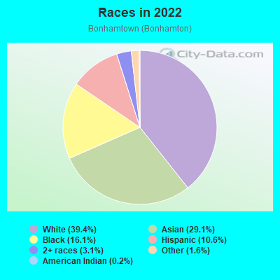
- 4,60539.4%White
- 3,40029.1%Asian
- 1,88216.1%Black
- 1,23710.6%Hispanic or Latino
- 3613.1%Two or more races
- 1891.6%Some other race
- 240.2%American Indian
Distribution of median household income
![Distribution of median household income]()
- 354Less than $10,000
- 637$10,000 to $19,999
- 307$20,000 to $29,999
- 283$30,000 to $39,999
- 270$40,000 to $49,999
- 192$50,000 to $59,999
- 301$60,000 to $74,999
- 561$75,000 to $99,999
- 463$100,000 to $124,999
- 479$125,000 to $149,999
- 854$150,000 to $199,999
- 806$200,000 or more

Distribution of owner-occupied house/condo value
![Distribution of owner-occupied house/condo value]()
- 1,084Less than $50,000
- 811$50,000 to $99,999
- 448$100,000 to $149,999
- 222$150,000 to $199,999
- 604$200,000 to $249,999
- 331$250,000 to $299,999
- 435$300,000 to $399,999
- 692$400,000 to $499,999
- 1,024$500,000 to $749,999
- 221$750,000 to $999,999
- 315$1,000,000 or more

Distribution of rent paid by renters
![Distribution of rent paid by renters]()
- 609Less than $100
- 122$100 to $199
- 863$200 to $299
- 372$300 to $399
- 195$400 to $499
- 424$500 to $599
- 313$600 to $699
- 129$700 to $799
- 566$800 to $899
- 119$900 to $999
- 197$1,000 to $1,249
- 245$1,250 to $1,499
- 1,192$1,500 to $1,999
- 1,412$2,000 or more

| Males: | 5,436 |
| Females: | 5,809 |
| Males: | |
| Females: |
Percentage of family households:
| Bonhamtown (Bonhamton): | 53.2% |
| New Jersey: | 47.0% |
| Here: | 56.6% |
| New Jersey: | 49.9% |
Percentage of married-couple families with children (among all households):
| Bonhamtown (Bonhamton): | 27.1% |
| New Jersey: | 51.5% |
Percentage of single-mother households (among all households):
| Bonhamtown (Bonhamton): | 9.8% |
| New Jersey: | 7.6% |
Percentage of never married males 15 years old and over:
Percentage of never married females 15 years old and over:
| Bonhamtown (Bonhamton): | 15.8% |
| New Jersey: | 18.2% |
Percentage of never married females 15 years old and over:
| Bonhamtown (Bonhamton): | 13.4% |
| New Jersey: | 16.6% |
Percentage of people that speak English not well or not at all:
| Bonhamtown (Bonhamton): | 4.4% |
| New Jersey: | 6.5% |
Percentage of people born in this state:
Percentage of people born in another U.S. state:
Percentage of native residents but born outside the U.S.:
Percentage of foreign born residents:
| Here: | 51.5% |
| New Jersey: | 50.7% |
Percentage of people born in another U.S. state:
| Bonhamtown (Bonhamton): | 16.5% |
| New Jersey: | 23.4% |
Percentage of native residents but born outside the U.S.:
| Here: | 1.3% |
| New Jersey: | 2.4% |
Percentage of foreign born residents:
| Here: | 30.7% |
| New Jersey: | 23.5% |

Owner-occupied
Renter-occupied

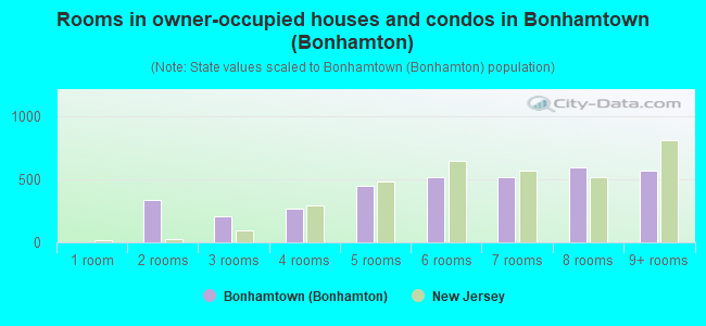
- Rooms in owner-occupied houses and condos in Bonhamtown <
> - 01 room
- 3402 rooms
- 2033 rooms
- 2694 rooms
- 4505 rooms
- 5146 rooms
- 5167 rooms
- 5928 rooms
- 5699+ rooms
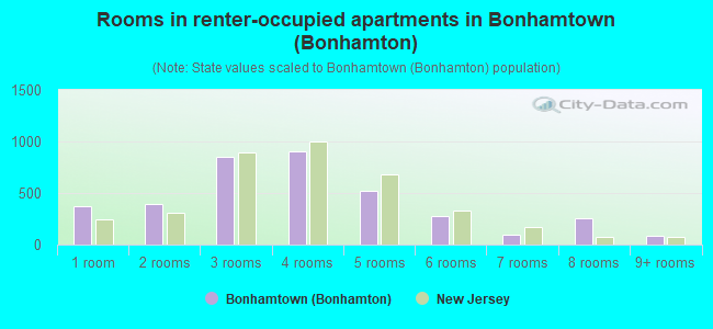
- Rooms in renter-occupied apartments in Bonhamtown <
> - 3711 room
- 3932 rooms
- 8513 rooms
- 9064 rooms
- 5265 rooms
- 2816 rooms
- 967 rooms
- 2608 rooms
- 869+ rooms
Owner-occupied
Renter-occupied
- Bedrooms in owner-occupied houses and condos in Bonhamtown <
> - 0no bedroom
- 2751 bedroom
- 6132 bedrooms
- 1,2443 bedrooms
- 9284 bedrooms
- 1805+ bedrooms
- Bedrooms in renter-occupied apartments in Bonhamtown <
> - 443no bedroom
- 1,3031 bedroom
- 8392 bedrooms
- 4123 bedrooms
- 524 bedrooms
- 565+ bedrooms
Average number of cars or other vehicles available in houses/condos:
Average number of cars or other vehicles available in apartments:
| This neighborhood: | |
| New Jersey: |
Average number of cars or other vehicles available in apartments:
| Here: | |
| New Jersey: |
Percentage of units with a mortgage:
| Bonhamtown (Bonhamton): | 66.7% |
| New Jersey: | 63.3% |
- Year house built in Bonhamtown <
> - 2412020 or later
- 2832010 to 2019
- 5392000 to 2009
- 8021990 to 1999
- 8681980 to 1989
- 5951970 to 1979
- 5901960 to 1969
- 7921950 to 1959
- 3701940 to 1949
- 7051939 or earlier
Travel time to work (commute)
![Travel time to work (commute)]()
- 215Less than 5 minutes
- 2755 to 9 minutes
- 68210 to 14 minutes
- 83315 to 19 minutes
- 63020 to 24 minutes
- 39325 to 29 minutes
- 62730 to 34 minutes
- 3135 to 39 minutes
- 20540 to 44 minutes
- 62445 to 59 minutes
- 76460 to 89 minutes
- 18790 or more minutes

Means of transportation to work
![Means of transportation to work]()
- 67.3%3,800Drove a car alone
- 4.0%226Carpooled
- 4.1%231Bus
- 4.1%233Subway or elevated rail
- 12.2%689Long-distance train or commuter rail
- 4.9%274Light rail, streetcar or trolley
- 9.0%506Taxi
- 0.1%3Motorcycle
- 1.0%59Bicycle
- 4.3%244Walked
- 2.9%164Other means
- 19.7%1,113Worked at home

Time leaving home to go to work
![Time leaving home to go to work]()
- 14212:00 a.m. to 4:59 a.m.
- 1385:00 a.m. to 5:29 a.m.
- 2025:30 a.m. to 5:59 a.m.
- 3896:00 a.m. to 6:29 a.m.
- 3046:30 a.m. to 6:59 a.m.
- 7167:00 a.m. to 7:29 a.m.
- 8327:30 a.m. to 7:59 a.m.
- 9368:00 a.m. to 8:29 a.m.
- 5938:30 a.m. to 8:59 a.m.
- 5109:00 a.m. to 9:59 a.m.
- 12310:00 a.m. to 10:59 a.m.
- 15911:00 a.m. to 11:59 a.m.
- 20812:00 p.m. to 3:59 p.m.
- 3544:00 p.m. to 11:59 p.m.

Occupations of males:
- Percentage of males in management occupations (except farmers):
Here: 22.1% New Jersey: 13.9%
- Percentage of males in business and financial operations occupations:
Here: 8.8% New Jersey: 6.9%
- Percentage of males in computer and mathematical occupations:
Here: 14.7% New Jersey: 6.5%
- Percentage of males in architecture and engineering occupations:
Here: 1.5% New Jersey: 3.1%
- Percentage of males in life, physical, and social science occupations:
Here: 3.0% New Jersey: 1.2%
- Percentage of males in education, training, and library occupations:
Here: 3.8% New Jersey: 3.6%
- Percentage of males in healthcare practitioners and technical occupations:
Here: 2.9% New Jersey: 3.2%
- Percentage of males in service occupations:
Here: 11.7% New Jersey: 12.9%
- Percentage of males in sales and office occupations:
Here: 11.1% New Jersey: 15.3%
- Percentage of males in construction, extraction, and maintenance occupations:
Here: 4.5% New Jersey: 8.1%
- Percentage of males in production occupations:
Here: 3.2% New Jersey: 4.8%
- Percentage of males in transportation occupations:
Here: 2.9% New Jersey: 6.5%
- Percentage of males in material moving occupations:
Here: 2.4% New Jersey: 4.7%
Occupations of females:
- Percentage of females in management occupations (except farmers):
Here: 14.0% New Jersey: 10.4%
- Percentage of females in business and financial operations occupations:
Here: 8.0% New Jersey: 7.3%
- Percentage of females in computer and mathematical occupations:
Here: 5.9% New Jersey: 2.4%
- Percentage of females in life, physical, and social science occupations:
Here: 1.7% New Jersey: 1.4%
- Percentage of females in community and social services occupations:
Here: 3.1% New Jersey: 2.6%
- Percentage of females in legal occupations:
Here: 3.5% New Jersey: 1.6%
- Percentage of females in education, training, and library occupations:
Here: 15.6% New Jersey: 11.4%
- Percentage of females in arts, design, entertainment, sports, and media occupations:
Here: 3.9% New Jersey: 2.2%
- Percentage of females in healthcare practitioners and technical occupations:
Here: 7.1% New Jersey: 9.6%
- Percentage of females in service occupations:
Here: 9.7% New Jersey: 17.2%
- Percentage of females in sales and office occupations:
Here: 25.8% New Jersey: 26.7%
Percentage of people 16-64 in Armed Forces:
| Bonhamtown (Bonhamton): | 0.0% |
| New Jersey: | 0.2% |
Education in this neighborhood (subdivision or community):
- Percentage of people 3 years and older in K-12 schools:
Bonhamtown (Bonhamton): 19.5% New Jersey: 16.6%
- Percentage of people 3 years and older in undergraduate colleges:
Bonhamtown (Bonhamton): 2.9% New Jersey: 4.9%
- Percentage of people 3 years and older in grad. or professional schools:
Bonhamtown (Bonhamton): 3.1% New Jersey: 1.6%
- Percentage of students K-12 enrolled in private schools:
Bonhamtown (Bonhamton): 107.6% New Jersey: 12.7%
Percentage of population below poverty level:
| Bonhamtown (Bonhamton): | 5.5% |
| New Jersey: | 9.7% |
Percentage of married-couple families with both working:
| Bonhamtown (Bonhamton): | 82.1% |
| New Jersey: | 72.0% |
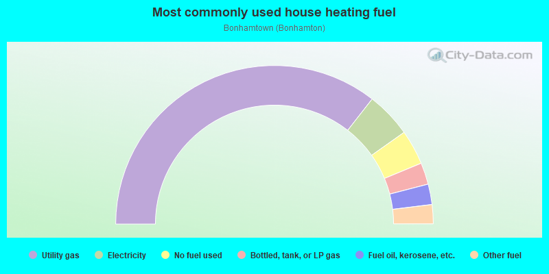
- 71.1%Utility gas
- 9.3%Electricity
- 7.1%No fuel used
- 4.4%Bottled, tank, or LP gas
- 4.2%Fuel oil, kerosene, etc.
- 3.9%Other fuel
Limited-access highways (interstate or state) in this neighborhood:
I- 287
Length: 2.91 miles
Directions: E-W, SE-NW
Directions: E-W, SE-NW
New Jersey Tpke (I- 95)
Length: 2.29 miles
Directions: E-W, SW-NE
Directions: E-W, SW-NE
Highways in this neighborhood:
US Hwy 1
Length: 2.37 miles
Direction: SW-NE
Address range: 880 to 1291
Direction: SW-NE
Address range: 880 to 1291
State Rte 27 (Essex Ave)
Length: 0.80 miles
Directions: E-W, SW-NE
Address range: 1 to 213
Directions: E-W, SW-NE
Address range: 1 to 213
State Rte 27 (Lincoln Hwy)
Length: 0.50 miles
Direction: SW-NE
Address range: 2196 to 2299
Direction: SW-NE
Address range: 2196 to 2299
State Rte 440
Length: 0.12 miles
Direction: E-W
Direction: E-W
Roads and streets:
Old Post Rd
Length: 1.54 miles
Directions: E-W, SE-NW, SW-NE
Address range: 469 to 770
Directions: E-W, SE-NW, SW-NE
Address range: 469 to 770
Main St
Length: 1.51 miles
Directions: N-S, SE-NW
Address range: 2 to 269
Directions: N-S, SE-NW
Address range: 2 to 269
Woodbridge Ave
Length: 1.32 miles
Directions: E-W, SW-NE
Address range: 2840 to 3039
Directions: E-W, SW-NE
Address range: 2840 to 3039
Vineyard Rd
Length: 1.24 miles
Directions: N-S, SE-NW, SW-NE
Address range: 1 to 252
Directions: N-S, SE-NW, SW-NE
Address range: 1 to 252
High St
Length: 1.00 miles
Direction: E-W
Address range: 3 to 345
Direction: E-W
Address range: 3 to 345
Whitman Ave
Length: 0.89 miles
Directions: E-W, SE-NW, SW-NE
Address range: 1 to 212
Directions: E-W, SE-NW, SW-NE
Address range: 1 to 212
Pierson Ave
Length: 0.76 miles
Direction: N-S
Address range: 13 to 339
Direction: N-S
Address range: 13 to 339
Rodak Cir
Length: 0.75 miles
Directions: E-W, N-S, SE-NW, SW-NE
Address range: 1 to 109
Directions: E-W, N-S, SE-NW, SW-NE
Address range: 1 to 109
Morris Ave
Length: 0.74 miles
Direction: E-W
Address range: 1 to 182
Direction: E-W
Address range: 1 to 182
Dorothy Ave
Length: 0.66 miles
Direction: N-S
Address range: 20 to 150
Direction: N-S
Address range: 20 to 150
Bernard Ave
Length: 0.57 miles
Direction: N-S
Address range: 1 to 158
Direction: N-S
Address range: 1 to 158
Rose St
Length: 0.55 miles
Direction: N-S
Address range: 40 to 315
Direction: N-S
Address range: 40 to 315
Newman St
Length: 0.54 miles
Directions: E-W, N-S, SE-NW
Address range: 1 to 299
Directions: E-W, N-S, SE-NW
Address range: 1 to 299
Lake Ave
Length: 0.53 miles
Directions: N-S, SE-NW
Address range: 1 to 219
Directions: N-S, SE-NW
Address range: 1 to 219
Heathcote Ave
Length: 0.50 miles
Directions: E-W, N-S, SW-NE
Address range: 1 to 69
Directions: E-W, N-S, SW-NE
Address range: 1 to 69
Spring St
Length: 0.46 miles
Direction: E-W
Address range: 38 to 140
Direction: E-W
Address range: 38 to 140
Harrison Ave
Length: 0.46 miles
Direction: E-W
Address range: 1 to 76
Direction: E-W
Address range: 1 to 76
Jeff St
Length: 0.45 miles
Directions: N-S, SE-NW, SW-NE
Address range: 1 to 239
Directions: N-S, SE-NW, SW-NE
Address range: 1 to 239
Orchard Ave
Length: 0.43 miles
Direction: E-W
Address range: 1 to 110
Direction: E-W
Address range: 1 to 110
Philo Blvd
Length: 0.42 miles
Direction: N-S
Address range: 1 to 99
Direction: N-S
Address range: 1 to 99
Howard Ave
Length: 0.42 miles
Directions: E-W, N-S, SW-NE
Address range: 1 to 199
Directions: E-W, N-S, SW-NE
Address range: 1 to 199
Edison Glen Ter
Length: 0.39 miles
Directions: E-W, N-S, SE-NW
Address range: 100 to 1899
Directions: E-W, N-S, SE-NW
Address range: 100 to 1899
Charles St
Length: 0.38 miles
Directions: E-W, SE-NW
Address range: 1 to 81
Directions: E-W, SE-NW
Address range: 1 to 81
S Heathcote Ave
Length: 0.35 miles
Directions: E-W, N-S, SE-NW
Address range: 1 to 99
Directions: E-W, N-S, SE-NW
Address range: 1 to 99
Brunswick Ave
Length: 0.34 miles
Direction: E-W
Address range: 1 to 106
Direction: E-W
Address range: 1 to 106
Myrtle Ave
Length: 0.33 miles
Direction: E-W
Address range: 1 to 111
Direction: E-W
Address range: 1 to 111
E Walnut St
Length: 0.33 miles
Direction: E-W
Address range: 1 to 108
Direction: E-W
Address range: 1 to 108
Poplar St
Length: 0.32 miles
Directions: E-W, N-S
Address range: 1 to 52
Directions: E-W, N-S
Address range: 1 to 52
Lodi Ave
Length: 0.31 miles
Direction: E-W
Direction: E-W
Pine St
Length: 0.31 miles
Direction: E-W
Address range: 2 to 32
Direction: E-W
Address range: 2 to 32
Martin Ave
Length: 0.31 miles
Direction: E-W
Address range: 1 to 99
Direction: E-W
Address range: 1 to 99
Mill Brook Rd
Length: 0.31 miles
Direction: E-W
Direction: E-W
Lincoln Ave
Length: 0.31 miles
Direction: E-W
Address range: 1 to 67
Direction: E-W
Address range: 1 to 67
Gibian St
Length: 0.29 miles
Direction: E-W
Address range: 1 to 99
Direction: E-W
Address range: 1 to 99
Ave C
Length: 0.29 miles
Directions: E-W, N-S, SE-NW, SW-NE
Address range: 3 to 99
Directions: E-W, N-S, SE-NW, SW-NE
Address range: 3 to 99
Alcoa Ave
Length: 0.29 miles
Direction: N-S
Address range: 15 to 184
Direction: N-S
Address range: 15 to 184
Prospect St
Length: 0.28 miles
Directions: N-S, SE-NW
Address range: 1 to 599
Directions: N-S, SE-NW
Address range: 1 to 599
Mc Pherson Ave
Length: 0.28 miles
Direction: E-W
Address range: 2 to 99
Direction: E-W
Address range: 2 to 99
Leland Rd
Length: 0.27 miles
Directions: E-W, N-S, SE-NW, SW-NE
Address range: 1 to 36
Directions: E-W, N-S, SE-NW, SW-NE
Address range: 1 to 36
Division St
Length: 0.25 miles
Direction: E-W
Address range: 1 to 75
Direction: E-W
Address range: 1 to 75
Kentnor St
Length: 0.25 miles
Direction: N-S
Address range: 47 to 98
Direction: N-S
Address range: 47 to 98
Cortland St
Length: 0.24 miles
Directions: N-S, SE-NW
Address range: 3 to 45
Directions: N-S, SE-NW
Address range: 3 to 45
Tived Ln E
Length: 0.24 miles
Directions: E-W, SE-NW, SW-NE
Address range: 101 to 142
Directions: E-W, SE-NW, SW-NE
Address range: 101 to 142
Bonham Dr
Length: 0.23 miles
Directions: E-W, N-S, SE-NW, SW-NE
Address range: 1 to 49
Directions: E-W, N-S, SE-NW, SW-NE
Address range: 1 to 49
S Locust Ave
Length: 0.23 miles
Directions: E-W, N-S, SE-NW
Address range: 2 to 38
Directions: E-W, N-S, SE-NW
Address range: 2 to 38
Orchard St
Length: 0.21 miles
Direction: E-W
Address range: 1 to 63
Direction: E-W
Address range: 1 to 63
Sylvan Ave
Length: 0.21 miles
Direction: N-S
Address range: 1 to 48
Direction: N-S
Address range: 1 to 48
Arbor Cir
Length: 0.20 miles
Directions: E-W, N-S, SE-NW, SW-NE
Address range: 1 to 31
Directions: E-W, N-S, SE-NW, SW-NE
Address range: 1 to 31
Hickory St
Length: 0.20 miles
Direction: E-W
Address range: 1 to 79
Direction: E-W
Address range: 1 to 79
Graham Ave
Length: 0.20 miles
Direction: N-S
Address range: 1 to 81
Direction: N-S
Address range: 1 to 81
Forest Haven Blvd
Length: 0.20 miles
Direction: SE-NW
Address range: 1107 to 2999
Direction: SE-NW
Address range: 1107 to 2999
Wilshire Rd
Length: 0.19 miles
Direction: N-S
Address range: 1 to 29
Direction: N-S
Address range: 1 to 29
Summit Ave
Length: 0.19 miles
Direction: N-S
Address range: 1 to 99
Direction: N-S
Address range: 1 to 99
Willard Dunham Dr
Length: 0.18 miles
Directions: E-W, N-S, SE-NW, SW-NE
Directions: E-W, N-S, SE-NW, SW-NE
Scott Ave
Length: 0.18 miles
Direction: E-W
Address range: 1 to 72
Direction: E-W
Address range: 1 to 72
Tulsa Ave
Length: 0.18 miles
Direction: E-W
Address range: 1 to 48
Direction: E-W
Address range: 1 to 48
Ginger Dr
Length: 0.18 miles
Directions: E-W, N-S, SE-NW
Address range: 1 to 45
Directions: E-W, N-S, SE-NW
Address range: 1 to 45
Gourmet Ln
Length: 0.18 miles
Directions: E-W, SE-NW
Address range: 1 to 99
Directions: E-W, SE-NW
Address range: 1 to 99
Mc Ginnis Rd
Length: 0.18 miles
Direction: N-S
Address range: 1 to 33
Direction: N-S
Address range: 1 to 33
Franklin Pl
Length: 0.18 miles
Direction: E-W
Address range: 1 to 49
Direction: E-W
Address range: 1 to 49
Prince St
Length: 0.18 miles
Directions: N-S, SE-NW
Address range: 1 to 34
Directions: N-S, SE-NW
Address range: 1 to 34
Spruce St
Length: 0.18 miles
Direction: N-S
Address range: 1 to 89
Direction: N-S
Address range: 1 to 89
Yelencsics Ct
Length: 0.17 miles
Direction: SE-NW
Address range: 100 to 399
Direction: SE-NW
Address range: 100 to 399
Marsh Ave
Length: 0.17 miles
Directions: N-S, SE-NW, SW-NE
Address range: 1 to 206
Directions: N-S, SE-NW, SW-NE
Address range: 1 to 206
Sheridan Ave
Length: 0.17 miles
Direction: E-W
Address range: 1 to 58
Direction: E-W
Address range: 1 to 58
Juniper St
Length: 0.17 miles
Direction: E-W
Address range: 1 to 35
Direction: E-W
Address range: 1 to 35
Rolfe Pl
Length: 0.16 miles
Directions: E-W, N-S, SE-NW, SW-NE
Address range: 1 to 81
Directions: E-W, N-S, SE-NW, SW-NE
Address range: 1 to 81
Cliffwood Pl
Length: 0.16 miles
Direction: N-S
Address range: 1 to 35
Direction: N-S
Address range: 1 to 35
Thomas St
Length: 0.16 miles
Direction: N-S
Address range: 1 to 71
Direction: N-S
Address range: 1 to 71
Wilson Ln
Length: 0.16 miles
Direction: E-W
Address range: 2 to 10
Direction: E-W
Address range: 2 to 10
Plymouth Pl
Length: 0.15 miles
Directions: E-W, SW-NE
Address range: 1 to 43
Directions: E-W, SW-NE
Address range: 1 to 43
Whelan St
Length: 0.15 miles
Direction: N-S
Address range: 1 to 58
Direction: N-S
Address range: 1 to 58
Winslow Rd
Length: 0.15 miles
Directions: E-W, N-S, SW-NE
Address range: 1 to 26
Directions: E-W, N-S, SW-NE
Address range: 1 to 26
W Walnut St
Length: 0.15 miles
Direction: E-W
Address range: 1 to 32
Direction: E-W
Address range: 1 to 32
Forsythia Dr
Length: 0.14 miles
Directions: E-W, SE-NW
Address range: 2 to 20
Directions: E-W, SE-NW
Address range: 2 to 20
Tived Ln
Length: 0.14 miles
Direction: E-W
Address range: 1 to 99
Direction: E-W
Address range: 1 to 99
E Cedar St
Length: 0.13 miles
Direction: E-W
Address range: 1 to 57
Direction: E-W
Address range: 1 to 57
Willow Ave
Length: 0.13 miles
Direction: N-S
Address range: 1 to 22
Direction: N-S
Address range: 1 to 22
Dundar Rd
Length: 0.13 miles
Directions: N-S, SE-NW
Address range: 1 to 24
Directions: N-S, SE-NW
Address range: 1 to 24
W Cedar St
Length: 0.13 miles
Direction: E-W
Address range: 1 to 25
Direction: E-W
Address range: 1 to 25
Joel Ave
Length: 0.12 miles
Direction: E-W
Address range: 1 to 40
Direction: E-W
Address range: 1 to 40
Park Pl
Length: 0.12 miles
Direction: E-W
Address range: 1 to 20
Direction: E-W
Address range: 1 to 20
George St
Length: 0.11 miles
Direction: N-S
Address range: 1 to 37
Direction: N-S
Address range: 1 to 37
Heman St
Length: 0.11 miles
Direction: E-W
Address range: 2 to 108
Direction: E-W
Address range: 2 to 108
Sheffield Pl
Length: 0.11 miles
Direction: E-W
Address range: 4 to 19
Direction: E-W
Address range: 4 to 19
Tivid Ln (Spruce St)
Length: 0.11 miles
Direction: N-S
Address range: 48 to 73
Direction: N-S
Address range: 48 to 73
Poets Ln
Length: 0.11 miles
Directions: E-W, N-S, SE-NW
Address range: 1 to 27
Directions: E-W, N-S, SE-NW
Address range: 1 to 27
Locust Ave
Length: 0.11 miles
Direction: N-S
Address range: 1 to 25
Direction: N-S
Address range: 1 to 25
Patricia St
Length: 0.11 miles
Direction: E-W
Address range: 1 to 14
Direction: E-W
Address range: 1 to 14
Ferndale Pl
Length: 0.10 miles
Direction: E-W
Address range: 1 to 40
Direction: E-W
Address range: 1 to 40
Grace St
Length: 0.10 miles
Direction: N-S
Direction: N-S
Laythan Rd
Length: 0.09 miles
Direction: SW-NE
Address range: 1 to 18
Direction: SW-NE
Address range: 1 to 18
Chokeberry Dr
Length: 0.09 miles
Direction: N-S
Address range: 1 to 21
Direction: N-S
Address range: 1 to 21
Elder Dr
Length: 0.09 miles
Direction: N-S
Address range: 1 to 20
Direction: N-S
Address range: 1 to 20
Delmar Pl
Length: 0.09 miles
Direction: E-W
Address range: 1 to 18
Direction: E-W
Address range: 1 to 18
Daffodil Dr
Length: 0.09 miles
Direction: N-S
Address range: 1 to 18
Direction: N-S
Address range: 1 to 18
Milton Ave (Milton St)
Length: 0.09 miles
Direction: N-S
Address range: 1 to 29
Direction: N-S
Address range: 1 to 29
Patrick Ave
Length: 0.09 miles
Direction: E-W
Address range: 1 to 46
Direction: E-W
Address range: 1 to 46
Kelly St
Length: 0.08 miles
Direction: N-S
Address range: 1 to 99
Direction: N-S
Address range: 1 to 99
Darrel Ct
Length: 0.08 miles
Directions: N-S, SE-NW, SW-NE
Address range: 1 to 25
Directions: N-S, SE-NW, SW-NE
Address range: 1 to 25
Terrill Rd
Length: 0.08 miles
Direction: E-W
Address range: 1 to 13
Direction: E-W
Address range: 1 to 13
Herold Pl
Length: 0.07 miles
Directions: N-S, SE-NW
Address range: 1 to 49
Directions: N-S, SE-NW
Address range: 1 to 49
Smith St
Length: 0.07 miles
Direction: N-S
Direction: N-S
Wynn Rd
Length: 0.07 miles
Direction: SE-NW
Address range: 1 to 14
Direction: SE-NW
Address range: 1 to 14
Westervelt Ave
Length: 0.07 miles
Direction: N-S
Address range: 55 to 85
Direction: N-S
Address range: 55 to 85
Council Pl
Length: 0.07 miles
Directions: E-W, N-S
Address range: 52 to 83
Directions: E-W, N-S
Address range: 52 to 83
Ely Ct
Length: 0.07 miles
Direction: N-S
Address range: 1 to 17
Direction: N-S
Address range: 1 to 17
Townsley St
Length: 0.06 miles
Direction: N-S
Address range: 2 to 106
Direction: N-S
Address range: 2 to 106
Lawrence St
Length: 0.06 miles
Direction: N-S
Address range: 1 to 20
Direction: N-S
Address range: 1 to 20
Kate Ln
Length: 0.06 miles
Direction: E-W
Address range: 1 to 46
Direction: E-W
Address range: 1 to 46
Grant Ct
Length: 0.05 miles
Direction: N-S
Address range: 1 to 14
Direction: N-S
Address range: 1 to 14
Bogler St
Length: 0.05 miles
Direction: E-W
Direction: E-W
Howell Pl (Howell St)
Length: 0.05 miles
Direction: N-S
Address range: 1 to 21
Direction: N-S
Address range: 1 to 21
Herman St
Length: 0.05 miles
Direction: E-W
Address range: 36 to 104
Direction: E-W
Address range: 36 to 104
Honey Ct
Length: 0.04 miles
Directions: N-S, SW-NE
Address range: 1 to 99
Directions: N-S, SW-NE
Address range: 1 to 99
Cherry St
Length: 0.04 miles
Direction: N-S
Address range: 59 to 85
Direction: N-S
Address range: 59 to 85
Burr Dr (Burr Ct)
Length: 0.04 miles
Directions: N-S, SE-NW
Directions: N-S, SE-NW
Rosta Rd
Length: 0.04 miles
Direction: SW-NE
Address range: 1 to 5
Direction: SW-NE
Address range: 1 to 5
Manning St
Length: 0.04 miles
Direction: N-S
Address range: 50 to 67
Direction: N-S
Address range: 50 to 67
Rockoff Ct
Length: 0.04 miles
Direction: E-W
Direction: E-W
Peach Ct
Length: 0.03 miles
Direction: E-W
Address range: 1 to 12
Direction: E-W
Address range: 1 to 12
Simon St
Length: 0.03 miles
Direction: N-S
Direction: N-S
Loeb Ct
Length: 0.03 miles
Direction: N-S
Address range: 1 to 16
Direction: N-S
Address range: 1 to 16
Townsley Ct
Length: 0.03 miles
Direction: SE-NW
Address range: 1 to 26
Direction: SE-NW
Address range: 1 to 26
Phoenix Ave
Length: 0.03 miles
Direction: SW-NE
Direction: SW-NE
Edgar Ave
Length: 0.02 miles
Direction: N-S
Direction: N-S
Chester Ct
Length: 0.02 miles
Direction: E-W
Direction: E-W
Carson Ave
Length: 0.02 miles
Direction: N-S
Direction: N-S
Railroad features:
Conrail RR
Length: 4.76 miles
Directions: E-W, N-S, SE-NW, SW-NE
Directions: E-W, N-S, SE-NW, SW-NE
Other features:
Mill Brk
Length: 1.50 miles
Directions: E-W, N-S, SE-NW, SW-NE
Directions: E-W, N-S, SE-NW, SW-NE