Barberton Eastside (Eastside Barberton) neighborhood in Barberton, Ohio (OH), 44203 detailed profile
Settings
X


Business Search - 14 Million verified businesses
Area: 4.712 square miles
Population: 10,067
Population density:
| Barberton Eastside (Eastside Barberton): | 2,137 people per square mile |
| Barberton: | 2,792 people per square mile |

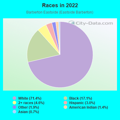
- 7,89671.4%White
- 1,88917.1%Black
- 5044.6%Two or more races
- 3313.0%Hispanic or Latino
- 2061.9%Some other race
- 1551.4%American Indian
- 720.7%Asian
Median household income in 2022:
| Barberton Eastside (Eastside Barberton): | $52,863 |
| Barberton: | $49,289 |
Distribution of median household income
![Distribution of median household income]()
- 341Less than $10,000
- 1,034$10,000 to $19,999
- 823$20,000 to $29,999
- 706$30,000 to $39,999
- 748$40,000 to $49,999
- 584$50,000 to $59,999
- 406$60,000 to $74,999
- 417$75,000 to $99,999
- 323$100,000 to $124,999
- 451$125,000 to $149,999
- 326$150,000 to $199,999
- 199$200,000 or more

Distribution of owner-occupied house/condo value
![Distribution of owner-occupied house/condo value]()
- 502Less than $50,000
- 1,971$50,000 to $99,999
- 1,620$100,000 to $149,999
- 528$150,000 to $199,999
- 411$200,000 to $249,999
- 327$250,000 to $299,999
- 168$300,000 to $399,999
- 30$400,000 to $499,999
- 55$500,000 to $749,999

Distribution of rent paid by renters
![Distribution of rent paid by renters]()
- 390Less than $100
- 249$100 to $199
- 1,049$200 to $299
- 4,255$300 to $399
- 476$400 to $499
- 1,070$500 to $599
- 471$600 to $699
- 740$700 to $799
- 504$800 to $899
- 269$900 to $999
- 215$1,000 to $1,249
- 52$1,250 to $1,499
- 1,024$2,000 or more

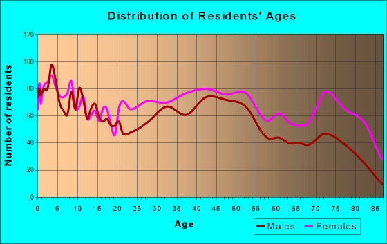
| Males: | 4,951 |
| Females: | 5,115 |
Males:
| This neighborhood: | 42.8 years |
| Whole city: | 39.3 years |
| This neighborhood: | 46.0 years |
| Whole city: | 41.6 years |
Average household size:
| Barberton Eastside (Eastside Barberton): | 4.6 people |
| Barberton: | 2.3 people |
Percentage of family households:
| Barberton Eastside (Eastside Barberton): | 37.1% |
| Barberton: | 40.8% |
| Here: | 28.8% |
| Barberton: | 35.4% |
Percentage of married-couple families with children (among all households):
| Barberton Eastside (Eastside Barberton): | 23.5% |
| Barberton: | 23.2% |
Percentage of single-mother households (among all households):
| Barberton Eastside (Eastside Barberton): | 23.5% |
| Barberton: | 17.5% |
Percentage of never married males 15 years old and over:
Percentage of never married females 15 years old and over:
| Barberton Eastside (Eastside Barberton): | 18.7% |
| Barberton: | 17.9% |
Percentage of never married females 15 years old and over:
| Barberton Eastside (Eastside Barberton): | 12.9% |
| city: | 14.9% |
Percentage of people that speak English not well or not at all:
| Barberton Eastside (Eastside Barberton): | 0.3% |
| Barberton: | 0.7% |
Percentage of people born in this state:
Percentage of people born in another U.S. state:
Percentage of native residents but born outside the U.S.:
Percentage of foreign born residents:
| Here: | 83.1% |
| Barberton: | 84.2% |
Percentage of people born in another U.S. state:
| Barberton Eastside (Eastside Barberton): | 14.7% |
| Barberton: | 13.9% |
Percentage of native residents but born outside the U.S.:
| Here: | 1.1% |
| city: | 0.5% |
Percentage of foreign born residents:
| Here: | 1.1% |
| Barberton: | 1.4% |
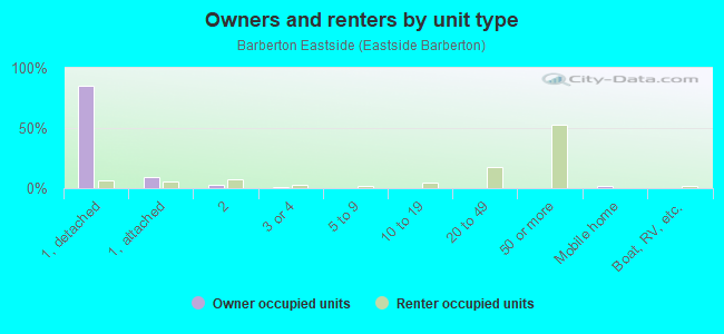
Owner-occupied
Renter-occupied

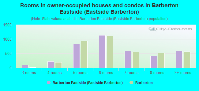
- Rooms in owner-occupied houses and condos in Barberton Eastside <
> - 01 room
- 02 rooms
- 943 rooms
- 2274 rooms
- 8435 rooms
- 1,1366 rooms
- 5997 rooms
- 4178 rooms
- 5869+ rooms
- Rooms in renter-occupied apartments in Barberton Eastside <
> - 1941 room
- 1,5342 rooms
- 1,2323 rooms
- 5094 rooms
- 4995 rooms
- 3096 rooms
- 3717 rooms
- 2158 rooms
- 3609+ rooms
Owner-occupied
Renter-occupied
- Bedrooms in owner-occupied houses and condos in Barberton Eastside <
> - 0no bedroom
- 1191 bedroom
- 7552 bedrooms
- 1,6373 bedrooms
- 3694 bedrooms
- 1765+ bedrooms
- Bedrooms in renter-occupied apartments in Barberton Eastside <
> - 200no bedroom
- 1,4671 bedroom
- 7392 bedrooms
- 4183 bedrooms
- 3504 bedrooms
- 2415+ bedrooms
Average number of cars or other vehicles available in houses/condos:
Average number of cars or other vehicles available in apartments:
| This neighborhood: | 1.4 |
| Barberton: | 1.8 |
Average number of cars or other vehicles available in apartments:
| Here: | 1.1 |
| city: | 1.2 |
Percentage of units with a mortgage:
| Barberton Eastside (Eastside Barberton): | 54.5% |
| Barberton: | 60.5% |
Average estimated value of detached houses in 2022 (65.0% of all units):
| Barberton Eastside (Eastside Barberton): | $122,874 |
| Ohio: | $254,366 |
- Year house built in Barberton Eastside <
> - 182020 or later
- 3692010 to 2019
- 1912000 to 2009
- 6511990 to 1999
- 1061980 to 1989
- 1,0221970 to 1979
- 5561960 to 1969
- 1,0561950 to 1959
- 5731940 to 1949
- 9591939 or earlier
City-data.com crime index for city in 2020 (higher means more crime):
| City: | 231.1 |
| U.S. average: | 219.5 |
Travel time to work (commute)
![Travel time to work (commute)]()
- 120Less than 5 minutes
- 5445 to 9 minutes
- 66710 to 14 minutes
- 89015 to 19 minutes
- 68020 to 24 minutes
- 17125 to 29 minutes
- 41430 to 34 minutes
- 7235 to 39 minutes
- 21440 to 44 minutes
- 16645 to 59 minutes
- 21760 to 89 minutes
- 15490 or more minutes

Means of transportation to work
![Means of transportation to work]()
- 86.2%3,408Drove a car alone
- 16.1%636Carpooled
- 2.0%80Bus
- 1.5%59Light rail, streetcar or trolley
- 1.4%54Taxi
- 2.7%106Motorcycle
- 0.6%25Bicycle
- 3.7%146Walked
- 4.5%177Other means
- 4.9%195Worked at home

Time leaving home to go to work
![Time leaving home to go to work]()
- 10812:00 a.m. to 4:59 a.m.
- 2125:00 a.m. to 5:29 a.m.
- 1975:30 a.m. to 5:59 a.m.
- 2696:00 a.m. to 6:29 a.m.
- 2576:30 a.m. to 6:59 a.m.
- 5857:00 a.m. to 7:29 a.m.
- 7617:30 a.m. to 7:59 a.m.
- 2928:00 a.m. to 8:29 a.m.
- 1258:30 a.m. to 8:59 a.m.
- 2989:00 a.m. to 9:59 a.m.
- 8510:00 a.m. to 10:59 a.m.
- 8711:00 a.m. to 11:59 a.m.
- 34712:00 p.m. to 3:59 p.m.
- 4444:00 p.m. to 11:59 p.m.

Occupations of males:
- Percentage of males in management occupations (except farmers):
Here: 2.4% city: 7.6%
- Percentage of males in business and financial operations occupations:
Here: 5.2% city: 4.1%
- Percentage of males in computer and mathematical occupations:
Here: 3.1% city: 3.3%
- Percentage of males in education, training, and library occupations:
Here: 1.3% city: 2.4%
- Percentage of males in arts, design, entertainment, sports, and media occupations:
Here: 3.3% city: 2.6%
- Percentage of males in healthcare practitioners and technical occupations:
Here: 3.3% city: 2.4%
- Percentage of males in service occupations:
Here: 15.7% city: 11.8%
- Percentage of males in sales and office occupations:
Here: 15.8% city: 17.2%
- Percentage of males in construction, extraction, and maintenance occupations:
Here: 6.1% city: 10.2%
- Percentage of males in production occupations:
Here: 23.6% city: 15.5%
- Percentage of males in transportation occupations:
Here: 2.1% city: 5.4%
- Percentage of males in material moving occupations:
Here: 9.3% city: 7.3%
Occupations of females:
- Percentage of females in management occupations (except farmers):
Here: 3.4% city: 5.1%
- Percentage of females in business and financial operations occupations:
Here: 4.2% city: 4.9%
- Percentage of females in education, training, and library occupations:
Here: 1.7% city: 6.5%
- Percentage of females in healthcare practitioners and technical occupations:
Here: 8.1% city: 9.0%
- Percentage of females in service occupations:
Here: 27.0% city: 23.9%
- Percentage of females in sales and office occupations:
Here: 46.7% city: 35.0%
- Percentage of females in construction, extraction, and maintenance occupations:
Here: 1.0% city: 0.6%
- Percentage of females in production occupations:
Here: 4.3% city: 5.4%
- Percentage of females in material moving occupations:
Here: 1.5% city: 3.6%
Percentage of people 16-64 in Armed Forces:
| Barberton Eastside (Eastside Barberton): | 0.0% |
| Barberton: | 0.5% |
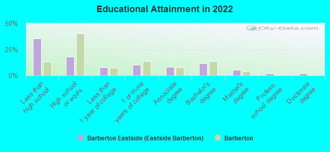
Education in this neighborhood (subdivision or community):
- Percentage of people 3 years and older in K-12 schools:
Barberton Eastside (Eastside Barberton): 23.7% Barberton: 16.6%
- Percentage of people 3 years and older in undergraduate colleges:
Barberton Eastside (Eastside Barberton): 5.5% Barberton: 3.4%
- Percentage of people 3 years and older in grad. or professional schools:
Barberton Eastside (Eastside Barberton): 1.4% Barberton: 0.5%
- Percentage of students K-12 enrolled in private schools:
Barberton Eastside (Eastside Barberton): 142.1% Barberton: 5.5%
Percentage of population below poverty level:
| Barberton Eastside (Eastside Barberton): | 19.6% |
| Barberton: | 16.1% |
Percentage of married-couple families with both working:
| Barberton Eastside (Eastside Barberton): | 78.9% |
| Barberton: | 72.5% |
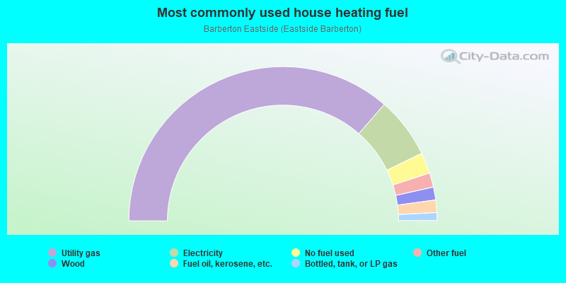
- 72.9%Utility gas
- 12.8%Electricity
- 4.4%No fuel used
- 3.0%Other fuel
- 2.7%Wood
- 2.6%Fuel oil, kerosene, etc.
- 1.7%Bottled, tank, or LP gas
Highways in this neighborhood:
5th St NE (State Rte 619)
Length: 1.35 miles
Directions: E-W, N-S, SE-NW, SW-NE
Address range: 1 to 608
Directions: E-W, N-S, SE-NW, SW-NE
Address range: 1 to 608
W Turkeyfoot Lake Rd (State Rte 619)
Length: 0.96 miles
Direction: SE-NW
Address range: 1628 to 2099
Direction: SE-NW
Address range: 1628 to 2099
State Rte 619 (5th St SE)
Length: 0.85 miles
Directions: N-S, SE-NW
Address range: 1 to 430
Directions: N-S, SE-NW
Address range: 1 to 430
Roads and streets:
Robinson Ave
Length: 2.91 miles
Direction: E-W
Address range: 56 to 1100
Direction: E-W
Address range: 56 to 1100
E Tuscarawas Ave
Length: 2.16 miles
Directions: E-W, SE-NW, SW-NE
Address range: 86 to 930
Directions: E-W, SE-NW, SW-NE
Address range: 86 to 930
E State St
Length: 1.75 miles
Direction: SE-NW
Address range: 1 to 811
Direction: SE-NW
Address range: 1 to 811
E Ford Ave
Length: 1.66 miles
Direction: E-W
Address range: 140 to 813
Direction: E-W
Address range: 140 to 813
E Paige Ave
Length: 1.54 miles
Directions: E-W, SW-NE
Address range: 191 to 827
Directions: E-W, SW-NE
Address range: 191 to 827
S Van Buren Ave
Length: 1.51 miles
Direction: N-S
Address range: 1 to 799
Direction: N-S
Address range: 1 to 799
Baird Ave
Length: 1.48 miles
Direction: E-W
Address range: 140 to 746
Direction: E-W
Address range: 140 to 746
E Cassell Ave
Length: 1.44 miles
Directions: E-W, SW-NE
Address range: 154 to 858
Directions: E-W, SW-NE
Address range: 154 to 858
Fairview Ave
Length: 1.40 miles
Directions: E-W, SE-NW
Address range: 1 to 899
Directions: E-W, SE-NW
Address range: 1 to 899
Snyder Ave
Length: 1.29 miles
Direction: E-W
Address range: 1 to 566
Direction: E-W
Address range: 1 to 566
E Lake Ave
Length: 1.28 miles
Direction: E-W
Address range: 200 to 749
Direction: E-W
Address range: 200 to 749
Huston St E
Length: 1.18 miles
Direction: E-W
Address range: 200 to 732
Direction: E-W
Address range: 200 to 732
S Azalea Blvd
Length: 1.17 miles
Directions: E-W, N-S, SE-NW, SW-NE
Address range: 800 to 1405
Directions: E-W, N-S, SE-NW, SW-NE
Address range: 800 to 1405
N Van Buren Ave
Length: 1.16 miles
Directions: N-S, SW-NE
Address range: 1 to 559
Directions: N-S, SW-NE
Address range: 1 to 559
E Hopocan Ave
Length: 1.16 miles
Direction: E-W
Address range: 250 to 719
Direction: E-W
Address range: 250 to 719
Washington Ave
Length: 1.06 miles
Direction: E-W
Address range: 280 to 720
Direction: E-W
Address range: 280 to 720
E Park Ave
Length: 1.03 miles
Direction: E-W
Address range: 136 to 724
Direction: E-W
Address range: 136 to 724
Eastern Rd
Length: 1.00 miles
Direction: E-W
Address range: 1576 to 2199
Direction: E-W
Address range: 1576 to 2199
Austin Dr
Length: 0.96 miles
Direction: E-W
Address range: 440 to 814
Direction: E-W
Address range: 440 to 814
Lincoln Ave
Length: 0.94 miles
Direction: E-W
Address range: 308 to 699
Direction: E-W
Address range: 308 to 699
Lockwood Rd
Length: 0.93 miles
Direction: E-W
Address range: 643 to 1699
Direction: E-W
Address range: 643 to 1699
7th St NE
Length: 0.89 miles
Direction: N-S
Address range: 1 to 482
Direction: N-S
Address range: 1 to 482
Mesa Verde Dr
Length: 0.82 miles
Directions: E-W, N-S, SE-NW, SW-NE
Address range: 617 to 999
Directions: E-W, N-S, SE-NW, SW-NE
Address range: 617 to 999
Franklin Ave
Length: 0.82 miles
Directions: E-W, SW-NE
Address range: 340 to 653
Directions: E-W, SW-NE
Address range: 340 to 653
4th St NE
Length: 0.79 miles
Direction: N-S
Address range: 34 to 425
Direction: N-S
Address range: 34 to 425
6th St NE
Length: 0.77 miles
Directions: N-S, SE-NW
Address range: 1 to 533
Directions: N-S, SE-NW
Address range: 1 to 533
E Tuscarawas Ave Exn
Length: 0.75 miles
Directions: E-W, SE-NW, SW-NE
Address range: 3229 to 3483
Directions: E-W, SE-NW, SW-NE
Address range: 3229 to 3483
Jefferson Ave
Length: 0.70 miles
Directions: E-W, SW-NE
Address range: 362 to 640
Directions: E-W, SW-NE
Address range: 362 to 640
8th St NE
Length: 0.68 miles
Direction: N-S
Address range: 1 to 358
Direction: N-S
Address range: 1 to 358
Homewood Ave
Length: 0.64 miles
Directions: E-W, N-S, SW-NE
Address range: 654 to 1509
Directions: E-W, N-S, SW-NE
Address range: 654 to 1509
N Azalea Blvd
Length: 0.63 miles
Directions: E-W, N-S, SE-NW
Address range: 582 to 850
Directions: E-W, N-S, SE-NW
Address range: 582 to 850
Grandview Ave
Length: 0.61 miles
Direction: E-W
Address range: 380 to 638
Direction: E-W
Address range: 380 to 638
3rd St NE
Length: 0.59 miles
Direction: N-S
Address range: 32 to 342
Direction: N-S
Address range: 32 to 342
Shenandoah Blvd
Length: 0.58 miles
Directions: E-W, N-S, SW-NE
Address range: 72 to 499
Directions: E-W, N-S, SW-NE
Address range: 72 to 499
9th St NE
Length: 0.56 miles
Direction: N-S
Address range: 1 to 304
Direction: N-S
Address range: 1 to 304
3rd St SE
Length: 0.54 miles
Directions: N-S, SE-NW
Address range: 1 to 282
Directions: N-S, SE-NW
Address range: 1 to 282
Elson Ave
Length: 0.54 miles
Direction: E-W
Address range: 160 to 378
Direction: E-W
Address range: 160 to 378
1st St SE
Length: 0.53 miles
Directions: N-S, SE-NW
Address range: 1 to 282
Directions: N-S, SE-NW
Address range: 1 to 282
2nd St SE
Length: 0.52 miles
Direction: N-S
Address range: 1 to 299
Direction: N-S
Address range: 1 to 299
2nd St NE
Length: 0.51 miles
Direction: N-S
Address range: 32 to 281
Direction: N-S
Address range: 32 to 281
Haven Ave
Length: 0.50 miles
Direction: E-W
Address range: 127 to 360
Direction: E-W
Address range: 127 to 360
Nola Ave
Length: 0.50 miles
Directions: E-W, SE-NW
Address range: 1100 to 1299
Directions: E-W, SE-NW
Address range: 1100 to 1299
Wisteria Dr
Length: 0.49 miles
Directions: E-W, N-S, SE-NW
Address range: 670 to 901
Directions: E-W, N-S, SE-NW
Address range: 670 to 901
Frank Ave
Length: 0.42 miles
Direction: N-S
Address range: 279 to 499
Direction: N-S
Address range: 279 to 499
Bell St
Length: 0.42 miles
Direction: N-S
Address range: 270 to 598
Direction: N-S
Address range: 270 to 598
George St
Length: 0.42 miles
Direction: N-S
Address range: 280 to 499
Direction: N-S
Address range: 280 to 499
1st St NE
Length: 0.39 miles
Directions: N-S, SE-NW
Address range: 1 to 219
Directions: N-S, SE-NW
Address range: 1 to 219
Akron View Dr
Length: 0.39 miles
Directions: N-S, SW-NE
Address range: 3300 to 3499
Directions: N-S, SW-NE
Address range: 3300 to 3499
Highland Ave
Length: 0.39 miles
Directions: E-W, SW-NE
Address range: 550 to 721
Directions: E-W, SW-NE
Address range: 550 to 721
Harold Ave
Length: 0.39 miles
Direction: E-W
Address range: 200 to 469
Direction: E-W
Address range: 200 to 469
Stanley Ave
Length: 0.38 miles
Direction: E-W
Address range: 200 to 353
Direction: E-W
Address range: 200 to 353
Magnolia Dr
Length: 0.37 miles
Directions: E-W, N-S, SW-NE
Address range: 292 to 499
Directions: E-W, N-S, SW-NE
Address range: 292 to 499
Lamberton Ave
Length: 0.36 miles
Direction: E-W
Address range: 300 to 499
Direction: E-W
Address range: 300 to 499
Quincy Ave
Length: 0.35 miles
Direction: E-W
Address range: 218 to 369
Direction: E-W
Address range: 218 to 369
Taft Ave
Length: 0.34 miles
Directions: E-W, SW-NE
Address range: 444 to 587
Directions: E-W, SW-NE
Address range: 444 to 587
Harter Ave
Length: 0.34 miles
Directions: E-W, N-S, SE-NW
Address range: 280 to 412
Directions: E-W, N-S, SE-NW
Address range: 280 to 412
Grace Ave
Length: 0.34 miles
Directions: N-S, SE-NW
Address range: 129 to 299
Directions: N-S, SE-NW
Address range: 129 to 299
Spruce St
Length: 0.33 miles
Directions: E-W, N-S, SE-NW, SW-NE
Address range: 300 to 499
Directions: E-W, N-S, SE-NW, SW-NE
Address range: 300 to 499
E Heatherwood Dr
Length: 0.30 miles
Directions: N-S, SW-NE
Address range: 186 to 399
Directions: N-S, SW-NE
Address range: 186 to 399
W Heatherwood Dr
Length: 0.29 miles
Directions: N-S, SE-NW
Address range: 188 to 338
Directions: N-S, SE-NW
Address range: 188 to 338
Meadowood Dr
Length: 0.27 miles
Directions: E-W, N-S, SW-NE
Address range: 800 to 999
Directions: E-W, N-S, SW-NE
Address range: 800 to 999
Dogwood Ln
Length: 0.26 miles
Directions: E-W, N-S, SE-NW, SW-NE
Address range: 64 to 124
Directions: E-W, N-S, SE-NW, SW-NE
Address range: 64 to 124
Portsmouth St (Portsmouth Ave)
Length: 0.26 miles
Direction: E-W
Address range: 337 to 436
Direction: E-W
Address range: 337 to 436
Wilson Ave
Length: 0.25 miles
Direction: E-W
Address range: 470 to 578
Direction: E-W
Address range: 470 to 578
Conservatory Dr
Length: 0.24 miles
Directions: E-W, N-S, SE-NW, SW-NE
Address range: 11 to 87
Directions: E-W, N-S, SE-NW, SW-NE
Address range: 11 to 87
Lenty Rd
Length: 0.24 miles
Direction: N-S
Address range: 4500 to 4599
Direction: N-S
Address range: 4500 to 4599
Mansion Dr
Length: 0.23 miles
Directions: E-W, N-S, SE-NW
Address range: 900 to 1161
Directions: E-W, N-S, SE-NW
Address range: 900 to 1161
Frisby Ave
Length: 0.23 miles
Direction: N-S
Address range: 270 to 399
Direction: N-S
Address range: 270 to 399
Thornwood Dr
Length: 0.23 miles
Directions: N-S, SE-NW
Address range: 801 to 867
Directions: N-S, SE-NW
Address range: 801 to 867
W Waterloo Rd (Waterloo Rd)
Length: 0.22 miles
Direction: E-W
Address range: 1423 to 1499
Direction: E-W
Address range: 1423 to 1499
Cordelia Ave
Length: 0.21 miles
Directions: E-W, N-S, SE-NW
Address range: 2600 to 2700
Directions: E-W, N-S, SE-NW
Address range: 2600 to 2700
Foundation Pl
Length: 0.21 miles
Direction: E-W
Address range: 19 to 99
Direction: E-W
Address range: 19 to 99
E Wolf Ave
Length: 0.21 miles
Directions: N-S, SE-NW, SW-NE
Address range: 201 to 299
Directions: N-S, SE-NW, SW-NE
Address range: 201 to 299
S Duff Dr
Length: 0.20 miles
Direction: E-W
Direction: E-W
Joseph St
Length: 0.20 miles
Direction: N-S
Address range: 279 to 401
Direction: N-S
Address range: 279 to 401
Edward Ave (Edward St)
Length: 0.19 miles
Direction: N-S
Address range: 270 to 385
Direction: N-S
Address range: 270 to 385
N Duff Dr
Length: 0.19 miles
Direction: E-W
Address range: 1900 to 2099
Direction: E-W
Address range: 1900 to 2099
Sonora Dr
Length: 0.19 miles
Directions: E-W, N-S, SE-NW, SW-NE
Address range: 600 to 699
Directions: E-W, N-S, SE-NW, SW-NE
Address range: 600 to 699
Macy Ave
Length: 0.19 miles
Direction: SE-NW
Address range: 121 to 216
Direction: SE-NW
Address range: 121 to 216
College St
Length: 0.19 miles
Direction: N-S
Address range: 280 to 382
Direction: N-S
Address range: 280 to 382
Cordova Dr
Length: 0.18 miles
Directions: N-S, SE-NW
Address range: 875 to 999
Directions: N-S, SE-NW
Address range: 875 to 999
Columbine Dr
Length: 0.18 miles
Direction: N-S
Address range: 850 to 1099
Direction: N-S
Address range: 850 to 1099
Rose Circle Dr
Length: 0.17 miles
Directions: E-W, N-S, SE-NW, SW-NE
Address range: 1200 to 1299
Directions: E-W, N-S, SE-NW, SW-NE
Address range: 1200 to 1299
Schwinn Dr
Length: 0.17 miles
Direction: N-S
Address range: 1 to 99
Direction: N-S
Address range: 1 to 99
Arroyo Dr
Length: 0.17 miles
Directions: E-W, N-S, SW-NE
Address range: 800 to 999
Directions: E-W, N-S, SW-NE
Address range: 800 to 999
Harding Ave
Length: 0.16 miles
Directions: E-W, SW-NE
Address range: 490 to 571
Directions: E-W, SW-NE
Address range: 490 to 571
Dan St
Length: 0.16 miles
Direction: N-S
Address range: 357 to 458
Direction: N-S
Address range: 357 to 458
Bellmawr Pl
Length: 0.16 miles
Direction: E-W
Address range: 564 to 617
Direction: E-W
Address range: 564 to 617
Kreider Ave
Length: 0.16 miles
Direction: N-S
Address range: 280 to 385
Direction: N-S
Address range: 280 to 385
Frew Dr
Length: 0.15 miles
Directions: E-W, N-S, SE-NW
Address range: 4586 to 4799
Directions: E-W, N-S, SE-NW
Address range: 4586 to 4799
Dahlia Cir
Length: 0.15 miles
Directions: E-W, N-S, SW-NE
Address range: 700 to 772
Directions: E-W, N-S, SW-NE
Address range: 700 to 772
Eagon St
Length: 0.15 miles
Direction: N-S
Address range: 1011 to 1099
Direction: N-S
Address range: 1011 to 1099
Grant Ave
Length: 0.15 miles
Direction: SE-NW
Address range: 121 to 212
Direction: SE-NW
Address range: 121 to 212
Walter Ave
Length: 0.14 miles
Direction: N-S
Address range: 1 to 51
Direction: N-S
Address range: 1 to 51
Foxglove Cir
Length: 0.13 miles
Direction: E-W
Address range: 819 to 882
Direction: E-W
Address range: 819 to 882
Tamarind Cir
Length: 0.13 miles
Direction: E-W
Address range: 819 to 882
Direction: E-W
Address range: 819 to 882
Mesquite Ln
Length: 0.13 miles
Directions: N-S, SW-NE
Address range: 880 to 922
Directions: N-S, SW-NE
Address range: 880 to 922
Promenade Cir
Length: 0.13 miles
Direction: E-W
Address range: 828 to 880
Direction: E-W
Address range: 828 to 880
Morning Breeze Cir
Length: 0.13 miles
Direction: E-W
Address range: 824 to 880
Direction: E-W
Address range: 824 to 880
Saguaro Pl
Length: 0.13 miles
Direction: E-W
Address range: 500 to 699
Direction: E-W
Address range: 500 to 699
Glenmere Pl
Length: 0.13 miles
Direction: E-W
Address range: 565 to 603
Direction: E-W
Address range: 565 to 603
Silver Ave
Length: 0.11 miles
Direction: N-S
Direction: N-S
Anna Dean Ln
Length: 0.11 miles
Direction: N-S
Address range: 550 to 619
Direction: N-S
Address range: 550 to 619
Milo Ave
Length: 0.11 miles
Direction: SE-NW
Address range: 121 to 199
Direction: SE-NW
Address range: 121 to 199
Arthur St
Length: 0.10 miles
Direction: E-W
Address range: 101 to 215
Direction: E-W
Address range: 101 to 215
Laurel Dr
Length: 0.10 miles
Direction: E-W
Direction: E-W
Teakwood Ct
Length: 0.10 miles
Direction: N-S
Address range: 500 to 599
Direction: N-S
Address range: 500 to 599
Phlox Pl
Length: 0.09 miles
Direction: E-W
Address range: 400 to 438
Direction: E-W
Address range: 400 to 438
Hyacinth Cir
Length: 0.09 miles
Direction: E-W
Address range: 312 to 357
Direction: E-W
Address range: 312 to 357
8th St SE
Length: 0.09 miles
Direction: N-S
Address range: 1 to 99
Direction: N-S
Address range: 1 to 99
Russell Ave
Length: 0.08 miles
Direction: E-W
Address range: 170 to 209
Direction: E-W
Address range: 170 to 209
Canna Cir
Length: 0.08 miles
Directions: E-W, SW-NE
Address range: 813 to 854
Directions: E-W, SW-NE
Address range: 813 to 854
Cedarwood Ct (Cedarwood Dr)
Length: 0.08 miles
Direction: N-S
Direction: N-S
Mansion Cir
Length: 0.08 miles
Direction: E-W
Address range: 900 to 999
Direction: E-W
Address range: 900 to 999
Hudson Run Rd
Length: 0.08 miles
Direction: E-W
Direction: E-W
Lilac Pl
Length: 0.06 miles
Direction: N-S
Address range: 217 to 275
Direction: N-S
Address range: 217 to 275
Cypress Pl
Length: 0.06 miles
Direction: SW-NE
Direction: SW-NE
W Waterloo Rd
Length: 0.06 miles
Direction: E-W
Address range: 1391 to 1518
Direction: E-W
Address range: 1391 to 1518
Canal St
Length: 0.06 miles
Direction: N-S
Address range: 99 to 235
Direction: N-S
Address range: 99 to 235
Crocus Pl
Length: 0.05 miles
Direction: E-W
Address range: 400 to 435
Direction: E-W
Address range: 400 to 435
Big Bend Cir
Length: 0.04 miles
Direction: N-S
Address range: 363 to 399
Direction: N-S
Address range: 363 to 399
Pasadena Pl
Length: 0.03 miles
Direction: E-W
Direction: E-W
Vista View St
Length: 0.02 miles
Direction: N-S
Direction: N-S
Railroad features:
Akron and Barberton Belt RR
Length: 3.65 miles
Directions: E-W, N-S, SE-NW, SW-NE
Directions: E-W, N-S, SE-NW, SW-NE
Csx RR
Length: 1.34 miles
Directions: N-S, SE-NW, SW-NE
Directions: N-S, SE-NW, SW-NE
Other features:
Tuscarawas Riv
Length: 4.45 miles
Directions: E-W, N-S, SE-NW, SW-NE
Directions: E-W, N-S, SE-NW, SW-NE
Other features:
Ohio Cnl
Length: 3.17 miles
Directions: E-W, N-S, SE-NW, SW-NE
Directions: E-W, N-S, SE-NW, SW-NE
Other features:
Cove Creek 1
Length: 0.89 miles
Directions: E-W, SE-NW, SW-NE
Directions: E-W, SE-NW, SW-NE
Cove Creek 2
Length: 0.58 miles
Directions: E-W, N-S
Directions: E-W, N-S
Mud Run
Length: 0.26 miles
Direction: N-S
Direction: N-S
Wolf Crk
Length: 0.22 miles
Directions: E-W, N-S, SE-NW
Directions: E-W, N-S, SE-NW