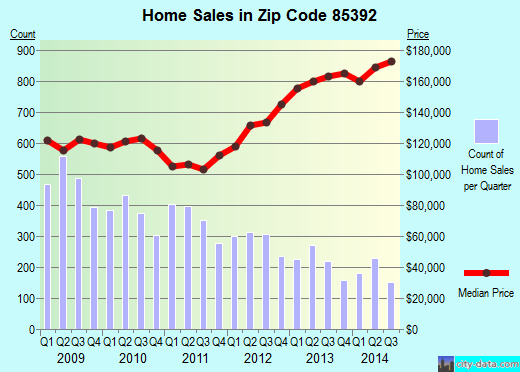
Property valuation of Roanoke Avenue, Avondale, AZ: 12825, 12826, 12829, 12830, 12833, 12834, 12837, 12838, 12842, 12846 (tax assessments)
Other nearby streets: Edgemont Avenue  Roanoke Avenue (1)
Roanoke Avenue (2)
Windsor Avenue (1)
Windsor Avenue (2)
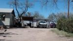
Roanoke Avenue (1)
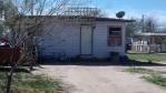
Roanoke Avenue (2)
Windsor Avenue (1)
Windsor Avenue (2)
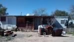
Roanoke Avenue (1)
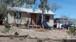
Roanoke Avenue (2)
Windsor Avenue (1)
Windsor Avenue (2)
Listed properties vs overall distribution of properties in Avondale, AZ:
Advertisements
12825 Roanoke Avenue
Avondale, AZ 85392
Find on map >>
Owner: CASSIMIRO M/MARY L NEPA
Total land value: $18,000 (it was $22,300 in 2009)
Total assessed value for land: $1,800 (it was $2,230 in 2009)
Total improvements value: $72,200 (it was $89,500 in 2009)
Total assessed value for improvements: $7,220 (it was $8,950 in 2009)
Total value for property: $83,820 (it was $111,800 in 2009)
Total assessed value for property: $8,382 (it was $11,180 in 2009)
Parcel's total lotsize: 4,320 square feet
Subdivision: Rancho Santa Fe Parcels 12,13,14 & 15
Date of current assessment: 02/22/2013
12826 Roanoke Avenue
Avondale, AZ 85392
Find on map >>
Owner: DIEP TAI
Total land value: $15,200 (it was $19,600 in 2009)
Total assessed value for land: $1,520 (it was $1,960 in 2009)
Total improvements value: $60,800 (it was $78,500 in 2009)
Total assessed value for improvements: $6,080 (it was $7,850 in 2009)
Total value for property: $71,280 (it was $98,100 in 2009)
Total assessed value for property: $7,128 (it was $9,810 in 2009)
Parcel's total lotsize: 4,050 square feet
Subdivision: Rancho Santa Fe Parcels 12,13,14 & 15
Date of current assessment: 02/22/2013
12829 Roanoke Avenue
Avondale, AZ 85392
Find on map >>
Owner: ALPINE BUILDING MATERIALS LLC 401K PLAN
Total land value: $15,200 (it was $19,700 in 2009)
Total assessed value for land: $1,520 (it was $1,970 in 2009)
Total improvements value: $60,800 (it was $79,100 in 2009)
Total assessed value for improvements: $6,080 (it was $7,910 in 2009)
Total value for property: $71,170 (it was $98,800 in 2009)
Total assessed value for property: $7,117 (it was $9,880 in 2009)
Parcel's total lotsize: 4,320 square feet
Subdivision: Rancho Santa Fe Parcels 12,13,14 & 15
Date of current assessment: 02/22/2013
12830 Roanoke Avenue
Avondale, AZ 85392
Find on map >>
Owner: DAVID L KEARNEY
Total land value: $15,000 (it was $19,500 in 2009)
Total assessed value for land: $1,500 (it was $1,950 in 2009)
Total improvements value: $60,200 (it was $78,200 in 2009)
Total assessed value for improvements: $6,020 (it was $7,820 in 2009)
Total value for property: $70,510 (it was $97,700 in 2009)
Total assessed value for property: $7,051 (it was $9,770 in 2009)
Parcel's total lotsize: 4,050 square feet
Subdivision: Rancho Santa Fe Parcels 12,13,14 & 15
Date of current assessment: 02/22/2013
12833 Roanoke Avenue
Avondale, AZ 85392
Find on map >>
Owner: GARY D FRANK
Total land value: $14,000 (it was $18,200 in 2009)
Total assessed value for land: $1,400 (it was $1,820 in 2009)
Total improvements value: $56,000 (it was $73,100 in 2009)
Total assessed value for improvements: $5,600 (it was $7,310 in 2009)
Total value for property: $66,000 (it was $91,300 in 2009)
Total assessed value for property: $6,600 (it was $9,130 in 2009)
Parcel's total lotsize: 4,320 square feet
Subdivision: Rancho Santa Fe Parcels 12,13,14 & 15
Date of current assessment: 02/22/2013
12834 Roanoke Avenue
Avondale, AZ 85392
Find on map >>
Owner: CARL R/CANDI J ANDERSON
Total land value: $14,000 (it was $18,100 in 2009)
Total assessed value for land: $1,400 (it was $1,810 in 2009)
Total improvements value: $56,000 (it was $72,500 in 2009)
Total assessed value for improvements: $5,600 (it was $7,250 in 2009)
Total value for property: $66,000 (it was $90,600 in 2009)
Total assessed value for property: $6,600 (it was $9,060 in 2009)
Parcel's total lotsize: 4,050 square feet
Subdivision: Rancho Santa Fe Parcels 12,13,14 & 15
Date of current assessment: 02/22/2013
12837 Roanoke Avenue
Avondale, AZ 85392
Find on map >>
Owner: JON/CIANFLONE GENNARO HOLEMAN
Total land value: $18,900 (it was $23,400 in 2009)
Total assessed value for land: $1,890 (it was $2,340 in 2009)
Total improvements value: $75,800 (it was $93,900 in 2009)
Total assessed value for improvements: $7,580 (it was $9,390 in 2009)
Total value for property: $87,780 (it was $117,300 in 2009)
Total assessed value for property: $8,778 (it was $11,730 in 2009)
Parcel's total lotsize: 4,788 square feet
Subdivision: Rancho Santa Fe Parcels 12,13,14 & 15
Date of current assessment: 02/22/2013
12838 Roanoke Avenue
Avondale, AZ 85392
Find on map >>
Owner: WENDY J MEYERS
Total land value: $16,400 (it was $20,800 in 2009)
Total assessed value for land: $1,640 (it was $2,080 in 2009)
Total improvements value: $65,800 (it was $83,500 in 2009)
Total assessed value for improvements: $6,580 (it was $8,350 in 2009)
Total value for property: $76,780 (it was $104,300 in 2009)
Total assessed value for property: $7,678 (it was $10,430 in 2009)
Parcel's total lotsize: 4,050 square feet
Subdivision: Rancho Santa Fe Parcels 12,13,14 & 15
Date of current assessment: 02/22/2013
12842 Roanoke Avenue
Avondale, AZ 85392
Find on map >>
Owner: FREO ARIZONA LLC
Total land value: $12,500 (it was $16,800 in 2009)
Total assessed value for land: $1,250 (it was $1,680 in 2009)
Total improvements value: $50,300 (it was $67,500 in 2009)
Total assessed value for improvements: $5,030 (it was $6,750 in 2009)
Total value for property: $59,620 (it was $84,300 in 2009)
Total assessed value for property: $5,962 (it was $8,430 in 2009)
Parcel's total lotsize: 4,087 square feet
Subdivision: Rancho Santa Fe Parcels 12,13,14 & 15
Date of current assessment: 02/22/2013
12846 Roanoke Avenue
Avondale, AZ 85392
Find on map >>
Owner: SCOTT/MARRI CONNOR
Total land value: $18,900 (it was $23,300 in 2009)
Total assessed value for land: $1,890 (it was $2,330 in 2009)
Total improvements value: $75,600 (it was $93,500 in 2009)
Total assessed value for improvements: $7,560 (it was $9,350 in 2009)
Total value for property: $87,450 (it was $116,800 in 2009)
Total assessed value for property: $8,745 (it was $11,680 in 2009)
Parcel's total lotsize: 4,672 square feet
Subdivision: Rancho Santa Fe Parcels 12,13,14 & 15
Date of current assessment: 02/22/2013
Other nearby streets: Edgemont Avenue
Roanoke Avenue (1)
Roanoke Avenue (2)
Windsor Avenue (1)
Windsor Avenue (2)
Roanoke Avenue (1)
Roanoke Avenue (2)
Windsor Avenue (1)
Windsor Avenue (2)

Recent posts about Avondale, Arizona on our local forum with over 2,400,000 registered users. Avondale is mentioned 3,272 times on our forum:

Settings
X

Recently Added Photos
Avondale, AZ
Tempe, AZ
Queen Creek, AZ
Marana, AZ
Marana, AZ
Marana, AZ
Marana, AZ
Marana, AZ
Marana, AZ

Peoria, AZ

Peoria, AZ
Peoria, AZ
Request disassociating your name from street-level assessment address

Recent home sales, price trends, and home value evaluator powered by Onboard Informatics
© 2024 Onboard Informatics. Information is deemed reliable but not guaranteed.
© 2024 Onboard Informatics. Information is deemed reliable but not guaranteed.
Some parts © 2024 Advameg, Inc.
Compilation, repackaging, or reproduction prohibited. Users are forewarned that it is incumbent upon them to verify information with the responsible state agency. Advameg, Inc. does not guarantee the data presented is up-to-date nor does it assume responsibility for updating it. Therefore any names, owners or addresses may have changed. Use of any information published here to contact the persons might be prohibited by the law.