Property valuation of Sharp Road, Katy, TX: 27010, 27010, 27627, 27627, 27711, 28338 (tax assessments)
Other nearby streets: Katy Hockley Road (1)  Katy Hockley Road (2)
Longenbaugh Road (1)
Longenbaugh Road (2)
Sharp Road
Katy Hockley Road (2)
Longenbaugh Road (1)
Longenbaugh Road (2)
Sharp Road
Katy Hockley Road (2)
Longenbaugh Road (1)
Longenbaugh Road (2)
Sharp Road
Listed properties vs overall distribution of properties in Katy, TX:
Advertisements
27010 Sharp Road
Katy, TX 77493
Find on map >>
Owner: MARK T MENKE & MARISELA MENKE
Land value: $131,769
Total value for property: $131,769
Assessments for tax year: 2015
Prior land value: $131,769
Prior total value for property: $131,769
Land size: 413,820 square feet
State classification: Real, Qualified Agricultural Land
Neighborhood: Farm
27010 Sharp Road
Katy, TX 77493
Find on map >>
Owner: MARK T MENKE & MARISELA MENKE
Land value: $7,079
Building value: $206,829
Extra features value: $7,244
Total value for property: $221,152
Assessments for tax year: 2015
Prior land value: $7,079
Prior building value: $106,473
Prior total value for property: $113,552
Building area: 3,273 square feet
Land size: 21,780 square feet
State classification: Real, Farm & Ranch Improved
Neighborhood: Farm
Year property was built: 1960
Condition / Desirability / Utility: Average
Exterior wall: Frame / Concrete block
Foundation type: Crawl Space
Grade adjustment: C+
Heating / AC: Central Heat/AC
Physical condition: Average
27627 Sharp Road
Katy, TX 77493
Find on map >>
Owner: PRAIRIE CONSERVANCY KATY
Land value: $44,938
Building value: $29,861
Extra features value: $2,301
Total value for property: $77,100
Assessments for tax year: 2015
Prior land value: $44,938
Prior building value: $31,619
Prior extra features value: $543
Prior total value for property: $77,100
Building area: 1,440 square feet
Land size: 59,917 square feet
State classification: Real, Residential, Mobile Homes
Neighborhood: M/R
Year property was built: 2000
Condition / Desirability / Utility: Average
Exterior wall: Aluminum / Vinyl
Foundation type: Crawl Space
Grade adjustment: D
Heating / AC: Central Heat/AC
Physical condition: Average
27627 Sharp Road
Katy, TX 77493
Find on map >>
Owner: PRAIRIE CONSERVANCY KATY
Land value: $78,408
Total value for property: $78,408
Assessments for tax year: 2015
Prior land value: $78,408
Prior total value for property: $78,408
Land size: 174,240 square feet
State classification: Real, Vacant Lots/Tracts (Not in City)
Neighborhood: M/R
27711 Sharp Road
Katy, TX 77493
Find on map >>
Owner: EDWARD W MCINTOSH III & JULIE A MCINTOSH
Land value: $100,192
Extra features value: $780
Total value for property: $100,972
Assessments for tax year: 2015
Prior land value: $100,192
Prior extra features value: $936
Prior total value for property: $101,128
Land size: 261,373 square feet
State classification: Real, Residential, Auxiliary Buildings
Neighborhood: M/R
28338 Sharp Road
Katy, TX 77493
Find on map >>
Owner: DEREK LYNN FREEMAN
Land value: $28,314
Building value: $53,365
Extra features value: $26,088
Total value for property: $107,767
Assessments for tax year: 2015
Prior land value: $28,314
Prior building value: $36,367
Prior extra features value: $32,948
Prior total value for property: $97,629
Building area: 1,300 square feet
Land size: 43,560 square feet
State classification: Real, Residential, Single-Family
Neighborhood: Farm
Year property was built: 1957
Condition / Desirability / Utility: Average
Cost and design: Total
Exterior wall: Frame / Concrete block
Foundation type: Crawl Space
Grade adjustment: C
Heating / AC: None
Physical condition: Fair
Other nearby streets: Katy Hockley Road (1)
Katy Hockley Road (2)
Longenbaugh Road (1)
Longenbaugh Road (2)
Sharp Road
Katy Hockley Road (2)
Longenbaugh Road (1)
Longenbaugh Road (2)
Sharp Road

Recent posts about Katy, Texas on our local forum with over 2,400,000 registered users. Katy is mentioned 29,958 times on our forum:
 | Feedback on Katy and Cypress Communities (49 replies) |
| Katy as an option with lots of questions (10 replies) |
| Difference in rankings for various Katy High Schools (8 replies) |
| North Katy area - west of 99/north of i10 (88 replies) |
| The suburbs (Katy) have more traffic congestion than the City limits (67 replies) |
| Another Spring vs Katy Post (15 replies) |
Settings
X

Recently Added Photos

Katy, TX

Katy, TX

Katy, TX

Katy, TX

Katy, TX

Katy, TX

Katy, TX

Dallas, TX

Dallas, TX

Dallas, TX
Dallas, TX

Dallas, TX
Request disassociating your name from street-level assessment address

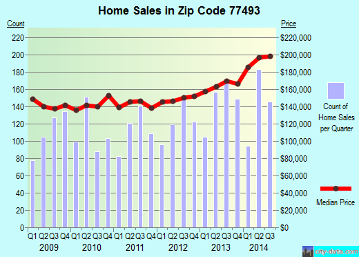
Recent home sales, price trends, and home value evaluator powered by Onboard Informatics
© 2024 Onboard Informatics. Information is deemed reliable but not guaranteed.
© 2024 Onboard Informatics. Information is deemed reliable but not guaranteed.
Some parts © 2024 Advameg, Inc.
Compilation, repackaging, or reproduction prohibited. Users are forewarned that it is incumbent upon them to verify information with the responsible state agency. Advameg, Inc. does not guarantee the data presented is up-to-date nor does it assume responsibility for updating it. Therefore any names, owners or addresses may have changed. Use of any information published here to contact the persons might be prohibited by the law.