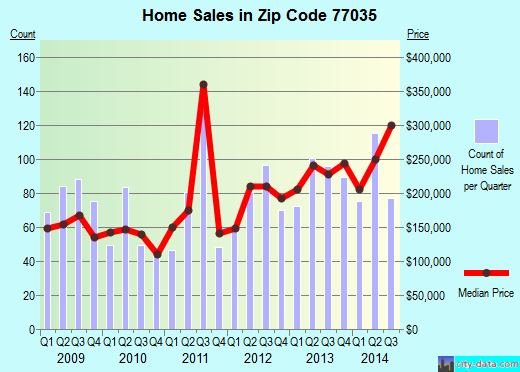
Property valuation of Rampart Street, Houston, TX: 11614, 11615, 11618, 11619, 11906, 11907, 11910, 11911, 11914, 12318 (tax assessments)
Other nearby streets: Cartagena Street (1)  Cartagena Street (2)
Ludington Drive (1)
Ludington Drive (2)
Ludington Drive (3)
Cartagena Street (2)
Ludington Drive (1)
Ludington Drive (2)
Ludington Drive (3)
Cartagena Street (2)
Ludington Drive (1)
Ludington Drive (2)
Ludington Drive (3)
Listed properties vs overall distribution of properties in Houston, TX:
Advertisements
11614 Rampart Street
Houston, TX 77035
Find on map >>
Owner: DARRELL L GERDES
Land value: $128,100
Building value: $65,900
Total value for property: $194,000
Assessments for tax year: 2015
Prior land value: $109,800
Prior building value: $73,460
Prior total value for property: $175,652
Building area: 1,902 square feet
Land size: 9,900 square feet
State classification: Real, Residential, Single-Family
Neighborhood: Westbury
Year property was built: 1960
Condition / Desirability / Utility: Average
Exterior wall: Brick / Veneer
Foundation type: Slab
Grade adjustment: C+
Heating / AC: Central Heat/AC
Physical condition: Average
11615 Rampart Street
Houston, TX 77035
Find on map >>
Owner: JENNIFER L NUTTALL
Land value: $118,090
Building value: $187,173
Total value for property: $305,263
Assessments for tax year: 2015
Prior land value: $101,220
Prior building value: $139,881
Prior total value for property: $241,101
Building area: 2,007 square feet
Land size: 8,470 square feet
State classification: Real, Residential, Single-Family
Neighborhood: Westbury
Year property was built: 1960
Condition / Desirability / Utility: Very Good
Cost and design: Partial
Exterior wall: Brick / Veneer
Foundation type: Slab
Grade adjustment: C+
Heating / AC: Central Heat/AC
Physical condition: Very Good
11618 Rampart Street
Houston, TX 77035
Find on map >>
Owner: BARRY MCNULTY
Land value: $136,920
Building value: $72,080
Total value for property: $209,000
Assessments for tax year: 2015
Prior land value: $117,360
Prior building value: $71,231
Prior extra features value: $3,617
Prior total value for property: $192,208
Building area: 2,035 square feet
Land size: 11,160 square feet
State classification: Real, Residential, Single-Family
Neighborhood: Westbury
Year property was built: 1960
Condition / Desirability / Utility: Average
Exterior wall: Brick / Veneer
Foundation type: Slab
Grade adjustment: C+
Heating / AC: Central Heat/AC
Physical condition: Average
11619 Rampart Street
Houston, TX 77035
Find on map >>
Owner: MYRNA THOMAS & TERRENCE THOMAS
Land value: $126,560
Building value: $78,994
Total value for property: $205,554
Assessments for tax year: 2015
Prior land value: $108,480
Prior building value: $66,671
Prior total value for property: $175,151
Building area: 1,962 square feet
Land size: 9,680 square feet
State classification: Real, Residential, Single-Family
Neighborhood: Westbury
Year property was built: 1960
Condition / Desirability / Utility: Fair
Exterior wall: Brick / Veneer
Foundation type: Slab
Grade adjustment: C+
Heating / AC: Central Heat/AC
Physical condition: Fair
11906 Rampart Street
Houston, TX 77035
Find on map >>
Owner: THOMAS TODD & DOROTHY N TODD
Land value: $126,480
Building value: $80,306
Extra features value: $450
Total value for property: $207,236
Assessments for tax year: 2015
Prior land value: $84,320
Prior building value: $72,950
Prior extra features value: $450
Prior total value for property: $157,720
Building area: 1,980 square feet
Land size: 12,800 square feet
State classification: Real, Residential, Single-Family
Neighborhood: Westbury
Year property was built: 1960
Condition / Desirability / Utility: Average
Exterior wall: Brick / Veneer
Foundation type: Slab
Grade adjustment: C+
Heating / AC: Central Heat/AC
Physical condition: Average
11907 Rampart Street
Houston, TX 77035
Find on map >>
Owner: STEVEN PENNA
Land value: $122,820
Building value: $85,215
Total value for property: $208,035
Assessments for tax year: 2015
Prior land value: $81,880
Prior building value: $77,390
Prior total value for property: $159,270
Building area: 1,585 square feet
Land size: 12,190 square feet
State classification: Real, Residential, Single-Family
Neighborhood: Westbury
Year property was built: 1960
Condition / Desirability / Utility: Average
Exterior wall: Brick / Veneer
Foundation type: Slab
Grade adjustment: C+
Heating / AC: Central Heat/AC
Physical condition: Average
11910 Rampart Street
Houston, TX 77035
Find on map >>
Owner: ROBERTO FLORES JR & IMELDA FLORES
Land value: $118,020
Building value: $63,824
Total value for property: $181,844
Assessments for tax year: 2015
Prior land value: $78,680
Prior building value: $44,070
Prior total value for property: $122,750
Building area: 1,585 square feet
Land size: 11,390 square feet
State classification: Real, Residential, Single-Family
Neighborhood: Westbury
Year property was built: 1960
Condition / Desirability / Utility: Average
Exterior wall: Brick / Veneer
Foundation type: Slab
Grade adjustment: C+
Heating / AC: Central Heat/AC
Physical condition: Average
11911 Rampart Street
Houston, TX 77035
Find on map >>
Owner: PINEAPPLE RENOVATIONS LLC
Land value: $123,720
Building value: $77,811
Extra features value: $410
Total value for property: $201,941
Assessments for tax year: 2015
Prior land value: $82,480
Prior building value: $70,681
Prior extra features value: $410
Prior total value for property: $153,571
Building area: 1,585 square feet
Land size: 12,340 square feet
State classification: Real, Residential, Single-Family
Neighborhood: Westbury
Year property was built: 1960
Condition / Desirability / Utility: Average
Exterior wall: Brick / Veneer
Foundation type: Slab
Grade adjustment: C+
Heating / AC: Central Heat/AC
Physical condition: Average
11914 Rampart Street
Houston, TX 77035
Find on map >>
Owner: JAMES MORGAN BAKER & TERRI BAKER
Land value: $143,460
Building value: $72,109
Extra features value: $258
Total value for property: $215,827
Assessments for tax year: 2015
Prior land value: $95,640
Prior building value: $65,516
Prior extra features value: $258
Prior total value for property: $161,414
Building area: 1,585 square feet
Land size: 15,630 square feet
State classification: Real, Residential, Single-Family
Neighborhood: Westbury
Year property was built: 1960
Condition / Desirability / Utility: Average
Exterior wall: Brick / Veneer
Foundation type: Slab
Grade adjustment: C+
Heating / AC: Central Heat/AC
Physical condition: Average
12318 Rampart Street
Houston, TX 77035
Find on map >>
Owner: ERNEST DELAUNE
Land value: $59,520
Building value: $62,808
Total value for property: $122,328
Assessments for tax year: 2015
Prior land value: $44,640
Prior building value: $51,654
Prior total value for property: $96,294
Building area: 1,530 square feet
Land size: 7,680 square feet
State classification: Real, Residential, Single-Family
Neighborhood: Westbury
Year property was built: 1962
Condition / Desirability / Utility: Fair
Exterior wall: Brick / Veneer
Foundation type: Slab
Grade adjustment: C
Heating / AC: Central Heat/AC
Physical condition: Fair
Other nearby streets: Cartagena Street (1)
Cartagena Street (2)
Ludington Drive (1)
Ludington Drive (2)
Ludington Drive (3)
Cartagena Street (2)
Ludington Drive (1)
Ludington Drive (2)
Ludington Drive (3)

Recent posts about Houston, Texas on our local forum with over 2,400,000 registered users. Houston is mentioned 165,460 times on our forum:
 | Houston to take over Chicago? (61 replies) |
| Houston CORE developments thread (767 replies) |
| Houston thoughts from someone who lives in DFW (63 replies) |
| Houston's economic diversity Thread .. (1271 replies) |
| Why I left Houston--why did YOU? (133 replies) |
| Why is Houston so ghetto? (339 replies) |
Settings
X

Recently Added Photos

Houston, TX

Houston, TX
Houston, TX
Houston, TX
Houston, TX

Houston, TX

Houston, TX

Houston, TX

Houston, TX

Houston, TX

Houston, TX

Houston, TX
Request disassociating your name from street-level assessment address

Recent home sales, price trends, and home value evaluator powered by Onboard Informatics
© 2024 Onboard Informatics. Information is deemed reliable but not guaranteed.
© 2024 Onboard Informatics. Information is deemed reliable but not guaranteed.
Some parts © 2024 Advameg, Inc.
Compilation, repackaging, or reproduction prohibited. Users are forewarned that it is incumbent upon them to verify information with the responsible state agency. Advameg, Inc. does not guarantee the data presented is up-to-date nor does it assume responsibility for updating it. Therefore any names, owners or addresses may have changed. Use of any information published here to contact the persons might be prohibited by the law.