Property valuation of Farmer Street, Houston, TX (tax assessments)

Listed properties vs overall distribution of properties in Houston, TX:
Advertisements
Farmer Street
Houston, TX 77020
Find on map >>
Owner: LAND A R AUTHORITY MAYORS OFFICE
Assessments for tax year: 2015
Land size: 3,750 square feet
State classification: Governmental Exempt
Neighborhood: Burke/Graham/Sydnor
Houston, TX 77020
Find on map >>
Owner: LAND A R AUTHORITY MAYORS OFFICE
Assessments for tax year: 2015
Land size: 3,750 square feet
State classification: Governmental Exempt
Neighborhood: Burke/Graham/Sydnor
Farmer Street
Houston, TX 77020
Find on map >>
Owner: CITY OF HOUSTON
Assessments for tax year: 2015
State classification: Governmental Exempt
Houston, TX 77020
Find on map >>
Owner: CITY OF HOUSTON
Assessments for tax year: 2015
State classification: Governmental Exempt
Farmer Street
Houston, TX 77020
Find on map >>
Owner: JESSE ANDERSON
Land value: $12,502
Total value for property: $12,502
Assessments for tax year: 2015
Prior land value: $12,502
Prior total value for property: $12,502
Land size: 3,150 square feet
State classification: Real, Vacant Lots/Tracts (In City)
Neighborhood: Burke/Graham/Sydnor
Farmer Street
Houston, TX 77020
Find on map >>
Owner: ANDERSON MEMORIAL CHURCH
Assessments for tax year: 2015
Land size: 2,025 square feet
State classification: Religious Exempt
Neighborhood: Burke/Graham/Sydnor
Houston, TX 77020
Find on map >>
Owner: ANDERSON MEMORIAL CHURCH
Assessments for tax year: 2015
Land size: 2,025 square feet
State classification: Religious Exempt
Neighborhood: Burke/Graham/Sydnor
Farmer Street
Houston, TX 77020
Find on map >>
Owner: ETHEL E BUSH
Land value: $14,021
Total value for property: $14,021
Assessments for tax year: 2015
Prior land value: $14,021
Prior total value for property: $14,021
Land size: 3,149 square feet
State classification: Real, Vacant Lots/Tracts (In City)
Neighborhood: August/Burke/Englewd/Lyons
Farmer Street
Houston, TX 77020
Find on map >>
Owner: JESSE ANDERSON
Land value: $11,479
Total value for property: $11,479
Assessments for tax year: 2015
Prior land value: $11,479
Prior total value for property: $11,479
Land size: 2,660 square feet
State classification: Real, Vacant Lots/Tracts (In City)
Neighborhood: Burke/Graham/Sydnor
Farmer Street
Houston, TX 77020
Find on map >>
Owner: ANDERSON MEMORIAL CHURCH
Assessments for tax year: 2015
Land size: 1,334 square feet
State classification: Religious Exempt
Neighborhood: Burke/Graham/Sydnor
Houston, TX 77020
Find on map >>
Owner: ANDERSON MEMORIAL CHURCH
Assessments for tax year: 2015
Land size: 1,334 square feet
State classification: Religious Exempt
Neighborhood: Burke/Graham/Sydnor
Farmer Street
Houston, TX 77020
Find on map >>
Owner: MEMORIAL COGIC ANDERSON
Assessments for tax year: 2015
Land size: 1,392 square feet
State classification: Religious Exempt
Neighborhood: Burke/Graham/Sydnor
Houston, TX 77020
Find on map >>
Owner: MEMORIAL COGIC ANDERSON
Assessments for tax year: 2015
Land size: 1,392 square feet
State classification: Religious Exempt
Neighborhood: Burke/Graham/Sydnor
Farmer Street
Houston, TX 77020
Find on map >>
Owner: THEODORE R ROCHELLE ESTATE
Land value: $5,704
Total value for property: $5,704
Assessments for tax year: 2015
Prior land value: $5,704
Prior total value for property: $5,704
Land size: 910 square feet
State classification: Real, Vacant Lots/Tracts (In City)
Neighborhood: Burke/Graham/Sydnor
Farmer Street
Houston, TX 77020
Find on map >>
Owner: DIMENSION 5 HOLDINGS LLC
Land value: $8,000
Total value for property: $8,000
Assessments for tax year: 2015
Prior land value: $8,000
Prior total value for property: $8,000
Land size: 4,028 square feet
State classification: Real, Vacant Lots/Tracts (In City)
Neighborhood: Burke/Graham/Sydnor

Recent posts about Houston, Texas on our local forum with over 2,400,000 registered users. Houston is mentioned 165,460 times on our forum:
 | Houston to take over Chicago? (61 replies) |
| Houston CORE developments thread (767 replies) |
| Houston thoughts from someone who lives in DFW (63 replies) |
| Houston's economic diversity Thread .. (1271 replies) |
| Why I left Houston--why did YOU? (133 replies) |
| Why is Houston so ghetto? (339 replies) |
Settings
X

Recently Added Photos
Houston, TX
Houston, TX
Houston, TX
Houston, TX
Houston, TX

Houston, TX

Houston, TX

Houston, TX

Houston, TX

Houston, TX

Houston, TX

Houston, TX
Request disassociating your name from street-level assessment address

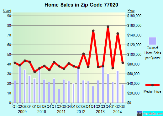
Recent home sales, price trends, and home value evaluator powered by Onboard Informatics
© 2024 Onboard Informatics. Information is deemed reliable but not guaranteed.
© 2024 Onboard Informatics. Information is deemed reliable but not guaranteed.
Some parts © 2024 Advameg, Inc.
Compilation, repackaging, or reproduction prohibited. Users are forewarned that it is incumbent upon them to verify information with the responsible state agency. Advameg, Inc. does not guarantee the data presented is up-to-date nor does it assume responsibility for updating it. Therefore any names, owners or addresses may have changed. Use of any information published here to contact the persons might be prohibited by the law.