Property valuation of Lillard Road, Chattanooga, TN: 13730, 13740 (tax assessments)
Other nearby streets: Schooner Bay Lane (1)  Schooner Bay Lane (2)
Scribner Road (1)
Scribner Road (2)
Sea Gull Lane
Schooner Bay Lane (2)
Scribner Road (1)
Scribner Road (2)
Sea Gull Lane
Schooner Bay Lane (2)
Scribner Road (1)
Scribner Road (2)
Sea Gull Lane
Listed properties vs overall distribution of properties in Chattanooga, TN:
Advertisements
Lillard Road
Chattanooga, TN
Find on map >>
First owner: LOWELL T LEWIS
Appraised land value: $18,800 (it was $18,800 in 2010)
Total appraised value for property: $18,800 (it was $18,800 in 2010)
Assessments for tax year: 2014
Property type: Residential
Land use: Undeveloped and Unused Land
Lands:
Sales:
Chattanooga, TN
Find on map >>
First owner: LOWELL T LEWIS
Appraised land value: $18,800 (it was $18,800 in 2010)
Total appraised value for property: $18,800 (it was $18,800 in 2010)
Assessments for tax year: 2014
Property type: Residential
Land use: Undeveloped and Unused Land
Lands:
-
Land use: Residential
Calculation method: Front Foot
Land area: 12,900 square feet
Road type: Tar & Gravel
Utilities: Electric, Water
Sales:
-
Sale date: 09/01/1973
Sale type: Quitclaim Deed
-
Sale date: 08/22/1987
Sale type: Combination Sale
-
Sale date: 07/22/2009
Sale type: Quitclaim Deed
Lillard Road
Chattanooga, TN
Find on map >>
First owner: TENN VALLEY AUTHORITY
Appraised land value: $2,655,800 (it was $2,660,000 in 2010)
Total appraised value for property: $2,655,800 (it was $2,660,000 in 2010)
Assessments for tax year: 2014
Property type: Federally Owned
Land use: Governmental Functions and Services
Lands:
-
Calculation method: Per Acre
Land area: 5,000 square feet
Road type: Tar & Gravel
Utilities: Electric
-
Calculation method: Per Acre
Land area: 2,650 square feet
Road type: Tar & Gravel
Utilities: Electric
Lillard Road
Chattanooga, TN
Find on map >>
First owner: MARIE F BROWN
Second owner: MARIE WINGATE C/O
Appraised land value: $22,700 (it was $22,700 in 2010)
Total appraised value for property: $22,700 (it was $22,700 in 2010)
Assessments for tax year: 2014
Property type: Residential
Land use: Undeveloped and Unused Land
Lands:
Sales:
Chattanooga, TN
Find on map >>
First owner: MARIE F BROWN
Second owner: MARIE WINGATE C/O
Appraised land value: $22,700 (it was $22,700 in 2010)
Total appraised value for property: $22,700 (it was $22,700 in 2010)
Assessments for tax year: 2014
Property type: Residential
Land use: Undeveloped and Unused Land
Lands:
-
Land use: Residential
Calculation method: Front Foot
Land area: 15,600 square feet
Road type: Tar & Gravel
Utilities: Electric, Water
Sales:
-
Sale date: 04/11/1975
Sale type: Quitclaim Deed
-
Sale date: 09/30/1977
Sale type: Quitclaim Deed
-
Sale date: 03/12/1985
Sale type: Warranty Deed
Lillard Road
Chattanooga, TN
Find on map >>
First owner: GEORGE M PHINIZEY JR ETAL
Appraised land value: $158,000 (it was $22,500 in 2010)
Total appraised value for property: $158,000 (it was $22,500 in 2010)
Assessments for tax year: 2014
Property type: Forest
Land use: Undeveloped and Unused Land
Lands:
Sales:
Chattanooga, TN
Find on map >>
First owner: GEORGE M PHINIZEY JR ETAL
Appraised land value: $158,000 (it was $22,500 in 2010)
Total appraised value for property: $158,000 (it was $22,500 in 2010)
Assessments for tax year: 2014
Property type: Forest
Land use: Undeveloped and Unused Land
Lands:
-
Land use: Residential
Calculation method: Per Acre
Land area: 3,300 square feet
Road type: Asphalt
Utilities: Electric, Water
-
Land use: Agricultural
Calculation method: Per Acre
Land area: 3,300 square feet
Road type: Asphalt
Utilities: Electric, Water
Sales:
-
Sale date: 06/24/1988
-
Sale date: 07/25/1988
-
Sale date: 05/09/2005
Sale type: Quitclaim Deed
-
Sale date: 03/02/2007
Sale type: Deed Reference
Lillard Road
Chattanooga, TN
Find on map >>
First owner: DONALD JOHN M MC
Appraised land value: $8,900 (it was $9,100 in 2010)
Total appraised value for property: $8,900 (it was $9,100 in 2010)
Assessments for tax year: 2014
Property type: Residential
Land use: Undeveloped and Unused Land
Lands:
Sales:
Chattanooga, TN
Find on map >>
First owner: DONALD JOHN M MC
Appraised land value: $8,900 (it was $9,100 in 2010)
Total appraised value for property: $8,900 (it was $9,100 in 2010)
Assessments for tax year: 2014
Property type: Residential
Land use: Undeveloped and Unused Land
Lands:
-
Land use: Residential
Calculation method: Per Acre
Land area: 130 square feet
Road type: No Road
Utilities: Electric
Sales:
-
Sale date: 06/24/2002
-
Sale date: 06/24/2002
-
Sale date: 12/07/2006
Sale type: Quitclaim Deed
-
Sale date: 09/17/2007
Sale type: Warranty Deed
Sale confirmation: Limited Confirmed Sale
Lillard Road
Chattanooga, TN
Find on map >>
First owner: LOWELL LEWIS
Appraised land value: $12,400 (it was $12,400 in 2010)
Total appraised value for property: $12,400 (it was $12,400 in 2010)
Assessments for tax year: 2014
Property type: Residential
Land use: Undeveloped and Unused Land
Lands:
Sales:
Chattanooga, TN
Find on map >>
First owner: LOWELL LEWIS
Appraised land value: $12,400 (it was $12,400 in 2010)
Total appraised value for property: $12,400 (it was $12,400 in 2010)
Assessments for tax year: 2014
Property type: Residential
Land use: Undeveloped and Unused Land
Lands:
-
Land use: Residential
Calculation method: Site Cost
Road type: Tar & Gravel
Utilities: Electric, Water
Sales:
-
Sale date: 12/01/1975
Sale type: Quitclaim Deed
-
Sale date: 03/24/1980
Sale type: Quitclaim Deed
-
Sale date: 06/27/1983
Sale type: Quitclaim Deed
-
Sale date: 10/30/1992
Sale type: Warranty Deed
Lillard Road
Chattanooga, TN
Find on map >>
First owner: VALERIE GILLESPIE
Second owner: VALERIE GRAY C/O
Appraised land value: $62,100 (it was $62,100 in 2010)
Total appraised value for property: $62,100 (it was $62,100 in 2010)
Assessments for tax year: 2014
Property type: Residential
Land use: Undeveloped and Unused Land
Lands:
Sales:
Chattanooga, TN
Find on map >>
First owner: VALERIE GILLESPIE
Second owner: VALERIE GRAY C/O
Appraised land value: $62,100 (it was $62,100 in 2010)
Total appraised value for property: $62,100 (it was $62,100 in 2010)
Assessments for tax year: 2014
Property type: Residential
Land use: Undeveloped and Unused Land
Lands:
-
Land use: Residential
Calculation method: Per Acre
Land area: 730 square feet
Road type: Tar & Gravel
Utilities: Electric, Water
Sales:
-
Sale date: 01/01/1943
Sale type: Quitclaim Deed
-
Sale date: 07/06/1987
Sale type: Family Sale
Lillard Road
Chattanooga, TN
Find on map >>
First owner: COMMUNITY NATIONAL BANK
Appraised land value: $157,500 (it was $158,000 in 2010)
Total appraised value for property: $157,500 (it was $158,000 in 2010)
Assessments for tax year: 2014
Property type: Residential
Land use: Undeveloped and Unused Land
Lands:
Sales:
Chattanooga, TN
Find on map >>
First owner: COMMUNITY NATIONAL BANK
Appraised land value: $157,500 (it was $158,000 in 2010)
Total appraised value for property: $157,500 (it was $158,000 in 2010)
Assessments for tax year: 2014
Property type: Residential
Land use: Undeveloped and Unused Land
Lands:
-
Land use: Residential
Calculation method: Per Acre
Land area: 3,099 square feet
Road type: Tar & Gravel
Utilities: Electric, Water
Sales:
-
Sale date: 04/18/2012
Sale type: Substitute Trustee Deed
-
Sale date: 06/07/2012
-
Sale date: 05/07/2013
Sale type: Decree of Redemption
-
Sale date: 05/07/2013
Sale type: Decree of Redemption
13730 Lillard Road
Chattanooga, TN
Find on map >>
First owner: MARTY WELLS
Appraised land value: $20,100 (it was $20,100 in 2010)
Appraised building value: $57,700 (it was $59,400 in 2010)
Total appraised value for property: $77,800 (it was $79,500 in 2010)
Assessments for tax year: 2014
Property type: Residential
Land use: One Family Household Unit
Buildings:
Lands:
Sales:
Chattanooga, TN
Find on map >>
First owner: MARTY WELLS
Appraised land value: $20,100 (it was $20,100 in 2010)
Appraised building value: $57,700 (it was $59,400 in 2010)
Total appraised value for property: $77,800 (it was $79,500 in 2010)
Assessments for tax year: 2014
Property type: Residential
Land use: One Family Household Unit
Buildings:
-
Current use: Residential
Year built: 2000
Effective year built: 2000
Base area: 1,344 square feet
Total adjusted area: 1,388 square feet
Appraised value: $55,200
-
Current use: Residential
Year built: 1998
Effective year built: 1998
Base area: 720 square feet
Total adjusted area: 720 square feet
Appraised value: $4,200
Lands:
-
Land use: Residential
Calculation method: Front Foot
Land area: 10,000 square feet
Road type: Tar & Gravel
Utilities: Electric, Water
Sales:
-
Sale date: 04/01/1975
Sale type: Quitclaim Deed
-
Sale date: 02/09/1987
Sale type: Quitclaim Deed
-
Sale date: 04/03/1997
Sale type: Warranty Deed
Sale confirmation: Limited Confirmed Sale
13740 Lillard Road
Chattanooga, TN
Find on map >>
First owner: KATHY DARLENE PARKER
Second owner: BETTY R PARKER
Appraised land value: $18,300 (it was $18,300 in 2010)
Appraised building value: $7,500 (it was $7,900 in 2010)
Total appraised value for property: $25,800 (it was $26,200 in 2010)
Assessments for tax year: 2014
Property type: Residential
Land use: Mobile Homes (Single Trailer)
Buildings:
Lands:
Sales:
Chattanooga, TN
Find on map >>
First owner: KATHY DARLENE PARKER
Second owner: BETTY R PARKER
Appraised land value: $18,300 (it was $18,300 in 2010)
Appraised building value: $7,500 (it was $7,900 in 2010)
Total appraised value for property: $25,800 (it was $26,200 in 2010)
Assessments for tax year: 2014
Property type: Residential
Land use: Mobile Homes (Single Trailer)
Buildings:
-
Current use: Residential
Year built: 1975
Effective year built: 1975
Base area: 1,440 square feet
Total adjusted area: 1,440 square feet
Appraised value: $5,100
-
Current use: Residential
Year built: 1980
Effective year built: 1980
Base area: 480 square feet
Total adjusted area: 480 square feet
Appraised value: $1,700
-
Current use: Residential
Year built: 1999
Effective year built: 1999
Base area: 240 square feet
Total adjusted area: 240 square feet
Appraised value: $1,100
Lands:
-
Land use: Residential
Calculation method: Front Foot
Land area: 9,000 square feet
Road type: Tar & Gravel
Utilities: Electric, Water
Sales:
-
Sale date: 04/01/1975
Sale type: Quitclaim Deed
-
Sale date: 08/28/1996
Sale type: Warranty Deed
-
Sale date: 09/28/2006
Sale type: Warranty Deed
Sale confirmation: Limited Confirmed Sale
Other nearby streets: Schooner Bay Lane (1)
Schooner Bay Lane (2)
Scribner Road (1)
Scribner Road (2)
Sea Gull Lane
Schooner Bay Lane (2)
Scribner Road (1)
Scribner Road (2)
Sea Gull Lane

Recent posts about Chattanooga, Tennessee on our local forum with over 2,400,000 registered users. Chattanooga is mentioned 6,919 times on our forum:
 | fun, outgoing, young hip couple, loves mountains: where to move? (10 replies) |
| Moving to TN (26 replies) |
| Floridian interested in area...( I know, ANOTHER one, lol!) (9 replies) |
| Seriously considering moving to Chattanooga - input please! (91 replies) |
| Looking for no more than 1.5 to 3.0 acres in the Chattanooga area (1 reply) |
| Spent 2 Days in Chattanooga (5 replies) |
Settings
X

Recently Added Photos

Chattanooga, TN

Chattanooga, TN

Chattanooga, TN

Chattanooga, TN

Chattanooga, TN

Chattanooga, TN

Chattanooga, TN

Chattanooga, TN

Chattanooga, TN

Chattanooga, TN

Chattanooga, TN

Chattanooga, TN
Request disassociating your name from street-level assessment address

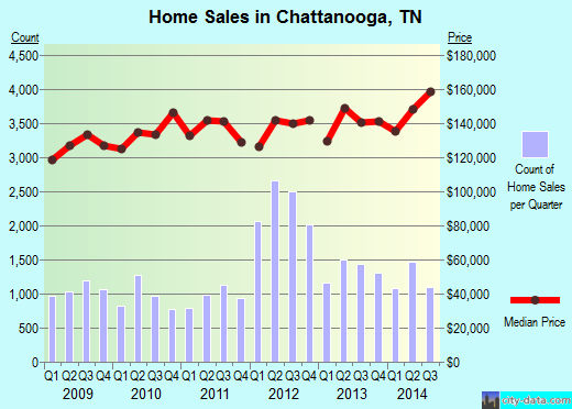
Recent home sales, price trends, and home value evaluator powered by Onboard Informatics
© 2024 Onboard Informatics. Information is deemed reliable but not guaranteed.
© 2024 Onboard Informatics. Information is deemed reliable but not guaranteed.
Some parts © 2024 Advameg, Inc.
Compilation, repackaging, or reproduction prohibited. Users are forewarned that it is incumbent upon them to verify information with the responsible state agency. Advameg, Inc. does not guarantee the data presented is up-to-date nor does it assume responsibility for updating it. Therefore any names, owners or addresses may have changed. Use of any information published here to contact the persons might be prohibited by the law.