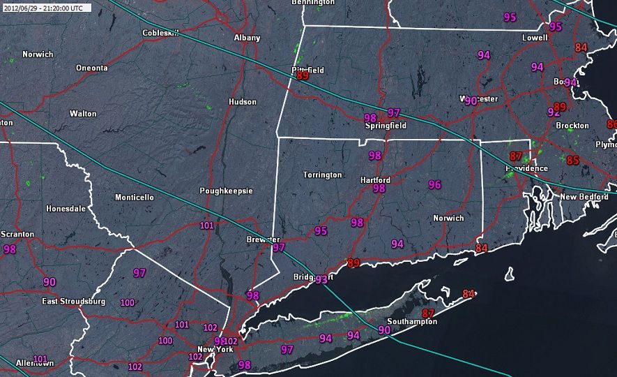
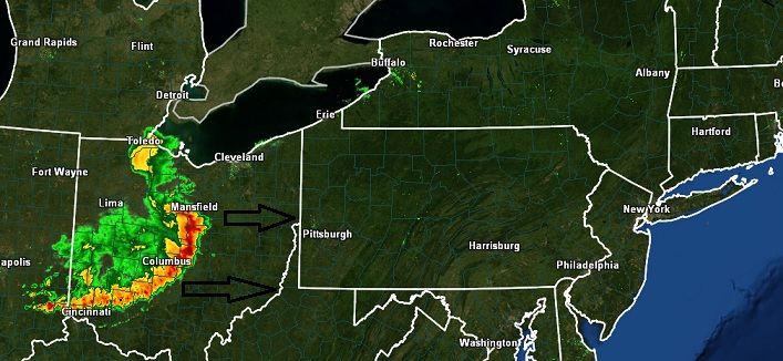
Just had a Spike this past hour that put entire state into the 90s. Uptons discussion mentions the insane MCS over Indiana that has produced an insane amount of wind damage reports. Whenever you see a bow like that in the radar, watch out. Upton is saying it should dissapate by the time it gets here but could redevelop. I'm wondering if we have another morning storm again since thats the trend we're in.
THE REGION CONTINUES TO LIE IN BETWEEN MEAN TROUGHING OVER
ONTARIO/QUEBEC AND STRONG SOUTHERN RIDGING. AT THE SURFACE...WEAK
THERMAL TROUGHING WILL DISSIPATE OVERNIGHT...WITH MAINLY CLEAR SKIES
AND LIGHT SW WINDS. THE ONLY CLOUDS WOULD BE FROM ANY CONVECTIVE
DEBRIS WORKING INTO THE AREA FROM MCS ACTIVITY TO THE S AND W.
WILL HAVE TO WATCH AN MCS OVER NORTHERN INDIANA...AS IT TRACKS ESE
THIS EVENING/OVERNIGHT AROUND THE RIDGE. CURRENT EXPECTATION IS FOR
IT TO DISSIPATE AND TRACK SE OF THE REGION...BUT WILL HAVE TO BE
WATCHED FOR ADDITIONAL ACTIVITY FLARING UP ALONG IT FLANKS OVERNIGHT.