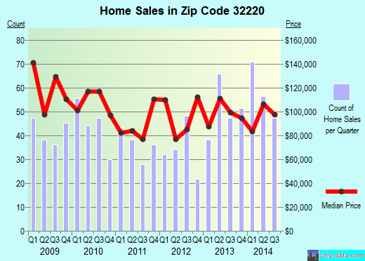
Property valuation of Manson Lane, Jacksonville, FL: 275, 276, 284, 285 (tax assessments)

Listed properties vs overall distribution of properties in Jacksonville, FL:
Advertisements
Manson Lane
Jacksonville, FL 32220
Find on map >>
Owner: KAREN K HELTON & KENNETH F HELTON
Total market value: $22,336
Total assessed value for property: $22,336
Total land value: $22,336
Land usage: Residential Land 3-7 Units Per Acre
Lot frontage: 167 feet
Lot depth: 167 feet
Assessment for fiscal year: 2008/2009
Manson Lane
Jacksonville, FL 32220
Find on map >>
Owner: CLEVELAND E WILLIAMS
Total market value: $15,958
Total assessed value for property: $15,958
Total land value: $12,480
Land usage: Residential Land 3-7 Units Per Acre
Lot frontage: 120 feet
Lot depth: 154 feet
Assessment for fiscal year: 2008/2009
Jacksonville, FL 32220
Find on map >>
Owner: CLEVELAND E WILLIAMS
Total market value: $15,958
Total assessed value for property: $15,958
Total land value: $12,480
Land usage: Residential Land 3-7 Units Per Acre
Lot frontage: 120 feet
Lot depth: 154 feet
Assessment for fiscal year: 2008/2009
Manson Lane
Jacksonville, FL 32220
Find on map >>
Owner: CAPPS TRUST
Total market value: $350,520
Total assessed value for property: $350,520
Total land value: $348,480
Land usage: Business Park 1,Borrow Pit & Drain Reserv
Assessment for fiscal year: 2008/2009
Jacksonville, FL 32220
Find on map >>
Owner: CAPPS TRUST
Total market value: $350,520
Total assessed value for property: $350,520
Total land value: $348,480
Land usage: Business Park 1,Borrow Pit & Drain Reserv
Assessment for fiscal year: 2008/2009
Manson Lane
Jacksonville, FL 32220
Find on map >>
Owner: NATHAN K BENNETT & HELEN A BENNETT
Total market value: $11,875
Total assessed value for property: $11,875
Total land value: $11,875
Land usage: Residential Land 3-7 Units Per Acre
Lot frontage: 125 feet
Lot depth: 119 feet
Assessment for fiscal year: 2008/2009
Manson Lane
Jacksonville, FL 32220
Find on map >>
Owner: OLD PLANK ROAD BAPTIST CHURCH
Total market value: $36,000
Total assessed value for property: $36,000
Total land value: $36,000
Land usage: Residential Land 3-7 Units Per Acre
Assessment for fiscal year: 2008/2009
Jacksonville, FL 32220
Find on map >>
Owner: OLD PLANK ROAD BAPTIST CHURCH
Total market value: $36,000
Total assessed value for property: $36,000
Total land value: $36,000
Land usage: Residential Land 3-7 Units Per Acre
Assessment for fiscal year: 2008/2009
Manson Lane
Jacksonville, FL 32220
Find on map >>
Owner: OLD PLANK ROAD BAPTIST CHURCH INC
Total market value: $47,940
Total assessed value for property: $47,940
Total land value: $47,940
Land usage: Residential Rural 2 Or Less Units Per Acre
Assessment for fiscal year: 2008/2009
Jacksonville, FL 32220
Find on map >>
Owner: OLD PLANK ROAD BAPTIST CHURCH INC
Total market value: $47,940
Total assessed value for property: $47,940
Total land value: $47,940
Land usage: Residential Rural 2 Or Less Units Per Acre
Assessment for fiscal year: 2008/2009
275 Manson Lane
Jacksonville, FL 32220
Find on map >>
Owner: GLENN F MILLER & TERRI L MILLER
Total market value: $81,649
Total assessed value for property: $80,166
Total building value: $48,761
Total land value: $32,000
Land usage: Residential Rural 2 Or Less Units Per Acre
Lot frontage: 112 feet
Lot depth: 630 feet
Assessment for fiscal year: 2008/2009
Building usage: Mobile Home Assessed Soh
Actual year built: 1995
Effective year built: 1995
Heated area: 1,836 square feet
Stories: 1
Bedrooms: 3
Baths: 2.50
Rooms / Units: 1
Base Area (actual / effective / heated): 1,836 / 1,836 / 1,836 square feet
276 Manson Lane
Jacksonville, FL 32220
Find on map >>
Owner: R KITTRELL LOUISE INC
Total market value: $33,216
Total assessed value for property: $33,216
Total land value: $32,000
Land usage: Residential Rural 2 Or Less Units Per Acre
Lot frontage: 115 feet
Lot depth: 630 feet
Assessment for fiscal year: 2008/2009
Building usage: Mobile Home Unassessed
Actual year built: 1992
Effective year built: 1992
Heated area: 1,336 square feet
Stories: 1
Bedrooms: 2
Baths: 2
Rooms / Units: 1
Base Area (actual / effective / heated): 1,336 / 1,336 / 1,336 square feet
Finished Open Porch (actual / effective / heated): 8 / 3 / 0 square feet
Unfinished Open Porch (actual / effective / heated): 135 / 34 / 0 square feet
284 Manson Lane
Jacksonville, FL 32220
Find on map >>
Owner: ROBERT E MILLER & NAOMI M MILLER
Total market value: $93,764
Total assessed value for property: $93,764
Total building value: $35,925
Total land value: $48,000
Land usage: Residential Rural 2 Or Less Units Per Acre
Assessment for fiscal year: 2008/2009
Building usage: Mobile Home Assessed Soh
Actual year built: 1993
Effective year built: 1993
Heated area: 1,344 square feet
Stories: 1
Bedrooms: 3
Baths: 2
Rooms / Units: 1
Base Area (actual / effective / heated): 1,344 / 1,344 / 1,344 square feet
285 Manson Lane
Jacksonville, FL 32220
Find on map >>
Owner: CHARLES ONEAL & BONNIE ONEAL
Total market value: $90,146
Total assessed value for property: $71,828
Total building value: $50,381
Total land value: $32,000
Land usage: Residential Rural 2 Or Less Units Per Acre
Lot frontage: 112 feet
Lot depth: 630 feet
Assessment for fiscal year: 2008/2009
Building usage: Mobile Home Assessed Soh
Actual year built: 1995
Effective year built: 1995
Heated area: 1,893 square feet
Stories: 1
Bedrooms: 3
Baths: 2
Rooms / Units: 1
Base Area (actual / effective / heated): 1,893 / 1,893 / 1,893 square feet
Finished Open Porch (actual / effective / heated): 12 / 4 / 0 square feet
Settings
X

Recently Added Photos

Jacksonville, FL

Jacksonville, FL

Jacksonville, FL

Jacksonville, FL

Jacksonville, FL
Jacksonville, FL

Jacksonville, FL

Jacksonville, FL

Jacksonville, FL

Jacksonville, FL

Jacksonville, FL

Jacksonville, FL
Request disassociating your name from street-level assessment address

Recent home sales, price trends, and home value evaluator powered by Onboard Informatics
© 2024 Onboard Informatics. Information is deemed reliable but not guaranteed.
© 2024 Onboard Informatics. Information is deemed reliable but not guaranteed.
Some parts © 2024 Advameg, Inc.
Compilation, repackaging, or reproduction prohibited. Users are forewarned that it is incumbent upon them to verify information with the responsible state agency. Advameg, Inc. does not guarantee the data presented is up-to-date nor does it assume responsibility for updating it. Therefore any names, owners or addresses may have changed. Use of any information published here to contact the persons might be prohibited by the law.