Property valuation of Wheatland Road, Dallas, TX: 1527, 1531, 1801, 1900, 1900, 1900, 1900, 1900, 7600 (tax assessments)
Other nearby streets: Ebb Tide Drive  Lenway Street (1)
Lenway Street (2)
Lenway Street (3)
Sedona Falls
Lenway Street (1)
Lenway Street (2)
Lenway Street (3)
Sedona Falls
Lenway Street (1)
Lenway Street (2)
Lenway Street (3)
Sedona Falls
Listed properties vs overall distribution of properties in Dallas, TX:
Advertisements
1527 Wheatland Road
Dallas, TX
Find on map >>
Owner: JAMES HENRISE & GLINDA HENRISE
Land value: $21,460
Total value for property: $21,460
Assessments for tax year: 2015
Previous total value for property: $21,460
Parcel usage: Commercial
Building class: Land Only
Land size: 155,770 square feet
Land usage: Commercial - Vacant Plotted Lots/Tracts
Zoning: Clustered Housing District
1531 Wheatland Road
Dallas, TX
Find on map >>
Owner: JAMES HENRISE & GLINDA HENRISE
Previous owner: JAEMS HENRISE & GLINDA HENRISE
Land value: $28,820
Total value for property: $28,820
Assessments for tax year: 2015
Previous total value for property: $28,820
Parcel usage: Commercial
Building class: Land Only
Land size: 209,262 square feet
Land usage: Commercial - Vacant Plotted Lots/Tracts
Zoning: Clustered Housing District
1801 Wheatland Road
Dallas, TX
Find on map >>
Owner: TEXAS STATE OF
Land value: $71,080
Total value for property: $71,080
Assessments for tax year: 2015
Previous total value for property: $71,080
Parcel usage: Commercial
Building class: Land Only
Land size: 1,548,078 square feet
Land usage: Commercial - Vacant Plotted Lots/Tracts
Zoning: Single Family District 7,500 S
1900 Wheatland Road
Dallas, TX
Find on map >>
Owner: PATRIOT REAL ESTATE HOLDINGS RS10
Previous owners:
Total value for property: $61,920
Assessments for tax year: 2015
Previous total value for property: $46,390
Parcel usage: Commercial
Building class: Land Only
Land size: 168,577 square feet
Land usage: Commercial - Vacant Plotted Lots/Tracts
Zoning: Single Family District 7,500 S
Dallas, TX
Find on map >>
Owner: PATRIOT REAL ESTATE HOLDINGS RS10
Previous owners:
- VENTURES LP KCMM
- MAG M GUERRA
Total value for property: $61,920
Assessments for tax year: 2015
Previous total value for property: $46,390
Parcel usage: Commercial
Building class: Land Only
Land size: 168,577 square feet
Land usage: Commercial - Vacant Plotted Lots/Tracts
Zoning: Single Family District 7,500 S
1900 Wheatland Road
Dallas, TX
Find on map >>
Owner: PATRIOT REAL ESTATE HOLDINGS RS10
Previous owners:
Total value for property: $59,680
Assessments for tax year: 2015
Previous total value for property: $48,000
Parcel usage: Commercial
Building class: Land Only
Land size: 162,478 square feet
Land usage: Commercial - Vacant Plotted Lots/Tracts
Zoning: Single Family District 7,500 S
Dallas, TX
Find on map >>
Owner: PATRIOT REAL ESTATE HOLDINGS RS10
Previous owners:
- VENTURES LP KCMM
- MEG M GUERRA
Total value for property: $59,680
Assessments for tax year: 2015
Previous total value for property: $48,000
Parcel usage: Commercial
Building class: Land Only
Land size: 162,478 square feet
Land usage: Commercial - Vacant Plotted Lots/Tracts
Zoning: Single Family District 7,500 S
1900 Wheatland Road
Dallas, TX
Find on map >>
Owner: PATRIOT REAL ESTATE HOLDINGS RS10
Previous owners:
Total value for property: $53,920
Assessments for tax year: 2015
Previous total value for property: $40,430
Parcel usage: Commercial
Building class: Land Only
Land size: 146,797 square feet
Land usage: Commercial - Vacant Plotted Lots/Tracts
Zoning: Single Family District 7,500 S
Dallas, TX
Find on map >>
Owner: PATRIOT REAL ESTATE HOLDINGS RS10
Previous owners:
- VENTURES LP KCMM
- MEG M GUERRA
Total value for property: $53,920
Assessments for tax year: 2015
Previous total value for property: $40,430
Parcel usage: Commercial
Building class: Land Only
Land size: 146,797 square feet
Land usage: Commercial - Vacant Plotted Lots/Tracts
Zoning: Single Family District 7,500 S
1900 Wheatland Road
Dallas, TX
Find on map >>
Owner: BCADG PPTY HOLDINGS I LLC
Previous owners:
Total value for property: $1,044,180
Assessments for tax year: 2015
Previous total value for property: $1,055,330
Parcel usage: Commercial
Building class: Land Only
Land size: 6,064,597 square feet
Land usage: Commercial - Vacant Plotted Lots/Tracts
Zoning: Agriculture District
Dallas, TX
Find on map >>
Owner: BCADG PPTY HOLDINGS I LLC
Previous owners:
- SPRINGS LP RUNYON
- 261 CW SPRINGS LTD
- PROVIDENCE BANK
Total value for property: $1,044,180
Assessments for tax year: 2015
Previous total value for property: $1,055,330
Parcel usage: Commercial
Building class: Land Only
Land size: 6,064,597 square feet
Land usage: Commercial - Vacant Plotted Lots/Tracts
Zoning: Agriculture District
1900 Wheatland Road
Dallas, TX
Find on map >>
Owner: CADG PPTY HOLDINGS I LLC
Previous owner: PROVIDENCE BANK
Land value: $2,310
Total value for property: $2,310
Assessments for tax year: 2015
Previous total value for property: $0
Parcel usage: Commercial
Building class: Land Only
Land size: 13,416 square feet
Land usage: Commercial - Vacant Plotted Lots/Tracts
Zoning: Agriculture District
7600 Wheatland Road
Dallas, TX
Find on map >>
Owner: DALLAS CITY OF
Business name: PARK IN THE WOODS
Land value: $123,540
Total value for property: $123,540
Assessments for tax year: 2015
Previous total value for property: $123,540
Parcel usage: Commercial
Building class: Land Only
Land size: 247,072 square feet
Land usage: Commercial - Vacant Plotted Lots/Tracts
Zoning: Community Retail District
Other nearby streets: Ebb Tide Drive
Lenway Street (1)
Lenway Street (2)
Lenway Street (3)
Sedona Falls
Lenway Street (1)
Lenway Street (2)
Lenway Street (3)
Sedona Falls

Recent posts about Dallas, Texas on our local forum with over 2,400,000 registered users. Dallas is mentioned 130,733 times on our forum:

Settings
X

Recently Added Photos

Dallas, TX

Dallas, TX

Dallas, TX

Dallas, TX

Dallas, TX
Dallas, TX

Dallas, TX

Dallas, TX

Dallas, TX

Dallas, TX

Dallas, TX

Dallas, TX
Request disassociating your name from street-level assessment address

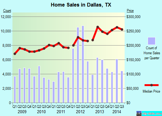
Recent home sales, price trends, and home value evaluator powered by Onboard Informatics
© 2024 Onboard Informatics. Information is deemed reliable but not guaranteed.
© 2024 Onboard Informatics. Information is deemed reliable but not guaranteed.
Some parts © 2024 Advameg, Inc.
Compilation, repackaging, or reproduction prohibited. Users are forewarned that it is incumbent upon them to verify information with the responsible state agency. Advameg, Inc. does not guarantee the data presented is up-to-date nor does it assume responsibility for updating it. Therefore any names, owners or addresses may have changed. Use of any information published here to contact the persons might be prohibited by the law.