Property valuation of Lottie Lane, Dallas, TX: 1203, 1206, 1208, 1212, 1215, 1217, 1220, 1223, 1224, 1227 (tax assessments)
Other nearby streets: Horizon Hills Drive  Lottie Lane
Seagoville Road (1)
Seagoville Road (2)
Seagoville Road (3)
Lottie Lane
Seagoville Road (1)
Seagoville Road (2)
Seagoville Road (3)
Lottie Lane
Seagoville Road (1)
Seagoville Road (2)
Seagoville Road (3)
Listed properties vs overall distribution of properties in Dallas, TX:
Advertisements
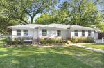
1203 Lottie Lane
Dallas, TX 75253
Find on map >>
Owner: ALBERT LOUIS BURKHAM
Previous owner: MINA BURKHAM ESTATE
Building value: $20,890
Land value: $23,000
Total value for property: $43,890
Assessments for tax year: 2015
Previous total value for property: $43,890
Parcel usage: Residential
Year property was built: 1954
Effective construction year: 1954
Building area: 864 square feet
Number of stories: 1
Construction: Frame
Foundation: Pier And Beam
Heating: Gas Heaters
Air conditioning: None
Fence: None
Exterior walls: Frame
Basement: None
Roof type: Gable
Roof material: Composite Shingles
Number of kitchens: 1
Number of full bathrooms: 1
Number of half bathrooms: 1
Number of bedrooms: 2
Additional improvements: Detached Garage
Land size: 38,325 square feet
Land usage: Single Family Residences
Zoning: Agriculture District
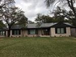
1206 Lottie Lane
Dallas, TX 75253
Find on map >>
Owner: ROGELIO LOPEZ
Building value: $63,360
Land value: $23,000
Total value for property: $86,360
Assessments for tax year: 2015
Previous total value for property: $86,360
Parcel usage: Residential
Year property was built: 2004
Effective construction year: 2004
Building area: 1,996 square feet
Number of stories: 1
Construction: Frame
Foundation: Slab
Heating: Central Full
Air conditioning: Central Full
Fence: Wood
Exterior walls: Brick Veneer
Basement: None
Roof type: Hip
Roof material: Composite Shingles
Number of kitchens: 1
Number of full bathrooms: 2
Number of bedrooms: 4
Additional improvements: Attached Garage, Storage Building
Land size: 39,500 square feet
Land usage: Single Family Residences
Zoning: Agriculture District
1208 Lottie Lane
Dallas, TX 75253
Find on map >>
Owner: EDDIE WAYNE PRYOR
Previous owner: LOTTIE PRYOR
Building value: $50,930
Land value: $23,000
Total value for property: $73,930
Assessments for tax year: 2015
Previous total value for property: $73,930
Parcel usage: Residential
Year property was built: 1977
Effective construction year: 1977
Building area: 1,308 square feet
Number of stories: 1
Construction: Frame
Foundation: Post
Heating: Central Full
Air conditioning: Central Full
Fence: Chain
Exterior walls: Aluminium
Basement: None
Roof type: Hip
Roof material: Composite Shingles
Number of fireplaces: 1
Number of kitchens: 1
Number of full bathrooms: 1
Number of bedrooms: 3
Additional improvements: Room Addition, Storage Building
Land size: 37,189 square feet
Land usage: Single Family Residences
Zoning: Agriculture District
1212 Lottie Lane
Dallas, TX
Find on map >>
Owner: FRANK M BROWN
Previous owner: FINIS E JOHNSON & MYRNA JOHNSON
Building value: $54,590
Land value: $23,000
Total value for property: $77,590
Assessments for tax year: 2015
Previous total value for property: $77,590
Parcel usage: Residential
Year property was built: 1940
Effective construction year: 1940
Building area: 1,895 square feet
Number of stories: 1
Construction: Frame
Foundation: Slab
Heating: Central Full
Air conditioning: Central Full
Fence: Iron
Exterior walls: Aluminium
Basement: None
Roof type: Gable
Roof material: Composite Shingles
Number of fireplaces: 1
Number of kitchens: 1
Number of full bathrooms: 1
Number of half bathrooms: 1
Number of bedrooms: 3
Additional improvements: Detached Garage, Room Addition, Storage Building
Land size: 36,887 square feet
Land usage: Single Family Residences
Zoning: Agriculture District
1215 Lottie Lane
Dallas, TX
Find on map >>
Owner: EMERALD ISLE LENDING CO
Previous owners:
Total value for property: $23,000
Assessments for tax year: 2015
Previous total value for property: $23,000
Parcel usage: Residential
Building class: Land Only
Land size: 38,586 square feet
Land usage: Single Family Residence - Vacant Lots/Tracts
Zoning: Agriculture District
Dallas, TX
Find on map >>
Owner: EMERALD ISLE LENDING CO
Previous owners:
- RONALD L LAFLEUR & KAREN LAFLEUR
- TERRY DIANE DIXON
Total value for property: $23,000
Assessments for tax year: 2015
Previous total value for property: $23,000
Parcel usage: Residential
Building class: Land Only
Land size: 38,586 square feet
Land usage: Single Family Residence - Vacant Lots/Tracts
Zoning: Agriculture District
1217 Lottie Lane
Dallas, TX
Find on map >>
Owner: EMERALD ISLE LENDING CO
Previous owners:
Total value for property: $23,000
Assessments for tax year: 2015
Previous total value for property: $23,000
Parcel usage: Residential
Building class: Land Only
Land size: 37,848 square feet
Land usage: Single Family Residence - Vacant Lots/Tracts
Zoning: Agriculture District
Dallas, TX
Find on map >>
Owner: EMERALD ISLE LENDING CO
Previous owners:
- RONALD L LAFLEUR & KAREN LAFLEUR
- TERRY DIANE DIXON
Total value for property: $23,000
Assessments for tax year: 2015
Previous total value for property: $23,000
Parcel usage: Residential
Building class: Land Only
Land size: 37,848 square feet
Land usage: Single Family Residence - Vacant Lots/Tracts
Zoning: Agriculture District
1220 Lottie Lane
Dallas, TX 75253
Find on map >>
Owner: REVECA FLORES SANTANA
Previous owners:
Land value: $23,000
Total value for property: $110,000
Assessments for tax year: 2015
Previous total value for property: $110,000
Parcel usage: Residential
Year property was built: 1983
Effective construction year: 1983
Building area: 1,760 square feet
Number of stories: 1
Construction: Frame
Foundation: Slab
Heating: Central Full
Air conditioning: Central Full
Fence: Wood
Exterior walls: Frame
Basement: None
Roof type: Gable
Roof material: Composite Shingles
Number of kitchens: 1
Number of full bathrooms: 2
Number of bedrooms: 3
Additional improvements: Detached Garage, Enclosed Patio, Storage Building
Land size: 36,998 square feet
Land usage: Single Family Residences
Zoning: Agriculture District
Dallas, TX 75253
Find on map >>
Owner: REVECA FLORES SANTANA
Previous owners:
- ANTHONY WAYNE PRYOR
- SALOMON PIEDRA
Land value: $23,000
Total value for property: $110,000
Assessments for tax year: 2015
Previous total value for property: $110,000
Parcel usage: Residential
Year property was built: 1983
Effective construction year: 1983
Building area: 1,760 square feet
Number of stories: 1
Construction: Frame
Foundation: Slab
Heating: Central Full
Air conditioning: Central Full
Fence: Wood
Exterior walls: Frame
Basement: None
Roof type: Gable
Roof material: Composite Shingles
Number of kitchens: 1
Number of full bathrooms: 2
Number of bedrooms: 3
Additional improvements: Detached Garage, Enclosed Patio, Storage Building
Land size: 36,998 square feet
Land usage: Single Family Residences
Zoning: Agriculture District
1223 Lottie Lane
Dallas, TX 75253
Find on map >>
Owner: BERNARD G MCPHERSON TR
Building value: $25,320
Land value: $23,000
Total value for property: $48,320
Assessments for tax year: 2015
Previous total value for property: $48,320
Parcel usage: Residential
Year property was built: 1940
Effective construction year: 1940
Building area: 961 square feet
Number of stories: 1
Construction: Frame
Foundation: Post
Heating: Gas Heaters
Air conditioning: None
Fence: None
Exterior walls: Aluminium
Basement: None
Roof type: Hip
Roof material: Composite Shingles
Number of kitchens: 1
Number of full bathrooms: 1
Number of bedrooms: 3
Additional improvements: Detached Garage, Storage Building
Land size: 38,105 square feet
Land usage: Single Family Residences
Zoning: Agriculture District
1224 Lottie Lane
Dallas, TX
Find on map >>
Owner: ELIAS BOTEO & ANAKARLA BOTEO
Previous owners:
Total value for property: $23,000
Assessments for tax year: 2015
Previous total value for property: $23,000
Parcel usage: Residential
Building class: Land Only
Land size: 42,367 square feet
Land usage: Single Family Residence - Vacant Lots/Tracts
Zoning: Agriculture District
Dallas, TX
Find on map >>
Owner: ELIAS BOTEO & ANAKARLA BOTEO
Previous owners:
- ANTHONY WAYNE PRYOR
- SOLOMON PIEDRA
- JESSIE L PIERCE
- JOSE L CASTILLO
Total value for property: $23,000
Assessments for tax year: 2015
Previous total value for property: $23,000
Parcel usage: Residential
Building class: Land Only
Land size: 42,367 square feet
Land usage: Single Family Residence - Vacant Lots/Tracts
Zoning: Agriculture District
1227 Lottie Lane
Dallas, TX 75253
Find on map >>
Owner: EDWARD WALKER DIAZ
Building value: $43,880
Land value: $23,000
Total value for property: $66,880
Assessments for tax year: 2015
Previous total value for property: $66,880
Parcel usage: Residential
Year property was built: 1940
Effective construction year: 1940
Building area: 1,400 square feet
Number of stories: 1
Construction: Frame
Foundation: Post
Heating: Central Full
Air conditioning: Central Full
Fence: Chain
Exterior walls: Aluminium
Basement: None
Roof type: Gable
Roof material: Composite Shingles
Number of kitchens: 1
Number of full bathrooms: 1
Number of bedrooms: 3
Additional improvements: Storage Building, Storage Building
Land size: 43,387 square feet
Land usage: Single Family Residences
Zoning: Agriculture District
Other nearby streets: Horizon Hills Drive
Lottie Lane
Seagoville Road (1)
Seagoville Road (2)
Seagoville Road (3)
Lottie Lane
Seagoville Road (1)
Seagoville Road (2)
Seagoville Road (3)

Recent posts about Dallas, Texas on our local forum with over 2,400,000 registered users. Dallas is mentioned 130,828 times on our forum:


Settings
X

Recently Added Photos

Dallas, TX

Dallas, TX

Dallas, TX
Dallas, TX

Dallas, TX
Dallas, TX
Dallas, TX

Dallas, TX
Dallas, TX
Dallas, TX

Dallas, TX

Dallas, TX
Request disassociating your name from street-level assessment address

Recent home sales, price trends, and home value evaluator powered by Onboard Informatics
© 2024 Onboard Informatics. Information is deemed reliable but not guaranteed.
© 2024 Onboard Informatics. Information is deemed reliable but not guaranteed.
Some parts © 2024 Advameg, Inc.
Compilation, repackaging, or reproduction prohibited. Users are forewarned that it is incumbent upon them to verify information with the responsible state agency. Advameg, Inc. does not guarantee the data presented is up-to-date nor does it assume responsibility for updating it. Therefore any names, owners or addresses may have changed. Use of any information published here to contact the persons might be prohibited by the law.