West Point-Wilseyville, California

Submit your own pictures of this place and show them to the world
- OSM Map
- Google Map
- MSN Map
| Males: 6,509 | |
| Females: 6,539 |
| Median resident age: | 48.9 years |
| California median age: | 33.3 years |
| West Point-Wilseyville: | $74,821 |
| CA: | $91,551 |
Estimated per capita income in 2022: $41,967 (it was $23,153 in 2000)
West Point-Wilseyville CCD income, earnings, and wages data
Estimated median house or condo value in 2022: $443,112 (it was $157,800 in 2000)
| West Point-Wilseyville: | $443,112 |
| CA: | $715,900 |
West Point-Wilseyville, CA residents, houses, and apartments details
Detailed information about poverty and poor residents in West Point-Wilseyville, CA


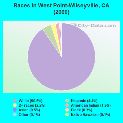
- 10,25290.5%White alone
- 4994.4%Hispanic
- 2472.2%Two or more races
- 2151.9%American Indian alone
- 570.5%Asian alone
- 350.3%Black alone
- 130.1%Native Hawaiian and Other
Pacific Islander alone - 160.1%Other race alone
 Recent articles from our blog. Our writers, many of them Ph.D. graduates or candidates, create easy-to-read articles on a wide variety of topics.
Current Local Time: PST time zone
Land area: 361.1 square miles.
Population density: 36 people per square mile (very low).
| West Point-Wilseyville CCD: | 0.9% ($1,380) |
| California: | 0.8% ($1,564) |
Nearest city with pop. 50,000+: South El Dorado, CA (31.5 miles  , pop. 78,296).
Nearest city with pop. 200,000+: Stockton, CA (57.9 miles , pop. 243,771).
Nearest city with pop. 1,000,000+: Los Angeles, CA (313.1 miles , pop. 3,694,820).
Nearest cities:
), ), )Latitude: 38.33 N, Longitude: 120.33 W
Area code commonly used in this area: 209
| Here: | 4.5% |
| California: | 5.1% |
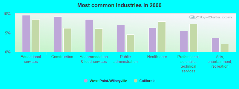
- Educational services (9.6%)
- Construction (9.3%)
- Accommodation & food services (8.5%)
- Public administration (7.1%)
- Health care (6.3%)
- Professional, scientific, technical services (5.5%)
- Arts, entertainment, recreation (3.7%)
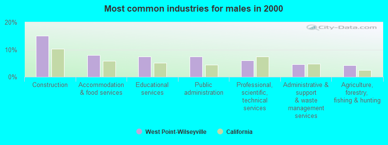
- Construction (15.0%)
- Accommodation & food services (8.0%)
- Educational services (7.5%)
- Public administration (7.4%)
- Professional, scientific, technical services (5.9%)
- Administrative & support & waste management services (4.6%)
- Agriculture, forestry, fishing & hunting (4.2%)
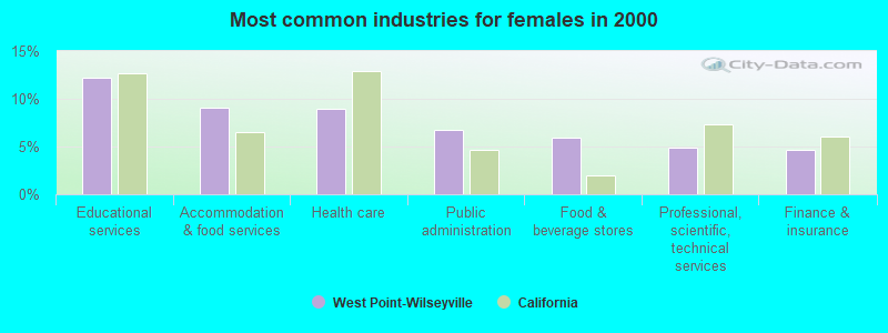
- Educational services (12.2%)
- Accommodation & food services (9.1%)
- Health care (8.9%)
- Public administration (6.7%)
- Food & beverage stores (6.0%)
- Professional, scientific, technical services (4.9%)
- Finance & insurance (4.7%)
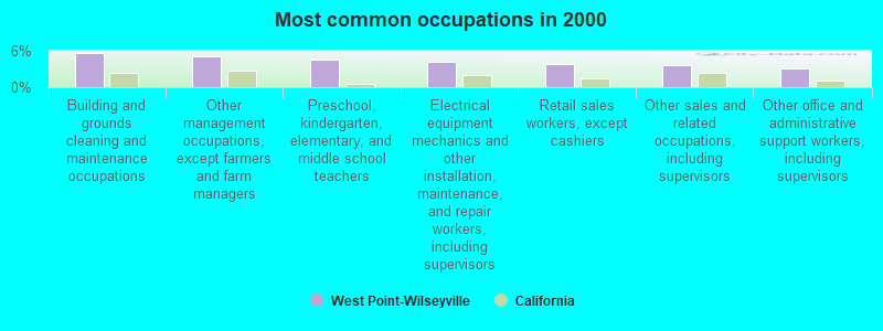
- Building and grounds cleaning and maintenance occupations (5.6%)
- Other management occupations, except farmers and farm managers (5.2%)
- Preschool, kindergarten, elementary, and middle school teachers (4.5%)
- Electrical equipment mechanics and other installation, maintenance, and repair workers, including supervisors (4.2%)
- Retail sales workers, except cashiers (3.9%)
- Other sales and related occupations, including supervisors (3.6%)
- Other office and administrative support workers, including supervisors (3.1%)
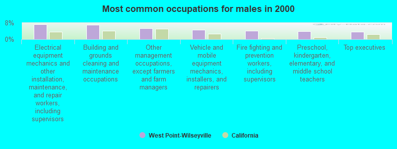
- Electrical equipment mechanics and other installation, maintenance, and repair workers, including supervisors (7.2%)
- Building and grounds cleaning and maintenance occupations (7.0%)
- Other management occupations, except farmers and farm managers (5.4%)
- Vehicle and mobile equipment mechanics, installers, and repairers (4.5%)
- Fire fighting and prevention workers, including supervisors (4.1%)
- Preschool, kindergarten, elementary, and middle school teachers (3.8%)
- Top executives (3.6%)
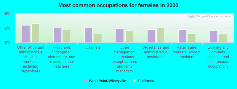
- Other office and administrative support workers, including supervisors (6.0%)
- Preschool, kindergarten, elementary, and middle school teachers (5.3%)
- Cashiers (5.1%)
- Other management occupations, except farmers and farm managers (4.8%)
- Secretaries and administrative assistants (4.6%)
- Retail sales workers, except cashiers (4.6%)
- Building and grounds cleaning and maintenance occupations (4.0%)
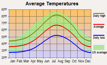
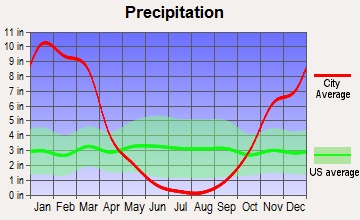
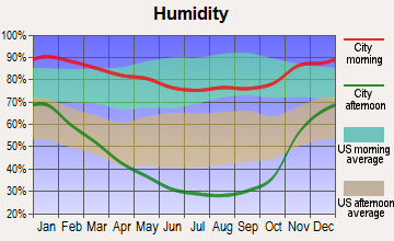
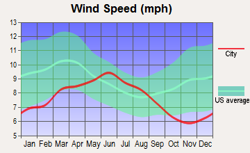
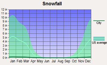
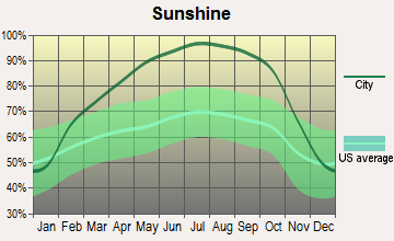
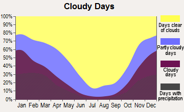
Average climate in West Point-Wilseyville, California
Based on data reported by over 4,000 weather stations
(lower is better)
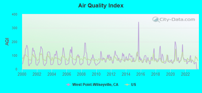
Air Quality Index (AQI) level in 2022 was 61.5. This is about average.
| City: | 61.5 |
| U.S.: | 72.6 |
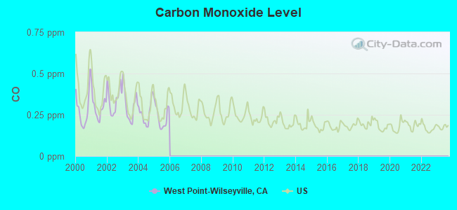
Carbon Monoxide (CO) [ppm] level in 2005 was 0.237. This is about average. Closest monitor was 20.7 miles away from the city center.
| City: | 0.237 |
| U.S.: | 0.251 |
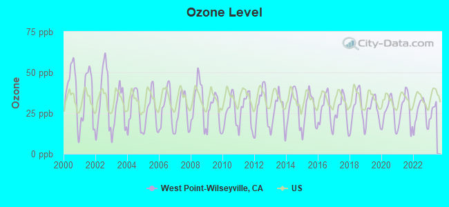
Ozone [ppb] level in 2022 was 25.0. This is better than average. Closest monitor was 19.3 miles away from the city center.
| City: | 25.0 |
| U.S.: | 33.3 |
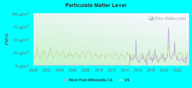
Particulate Matter (PM10) [µg/m3] level in 2022 was 11.8. This is significantly better than average. Closest monitor was 20.7 miles away from the city center.
| City: | 11.8 |
| U.S.: | 19.2 |
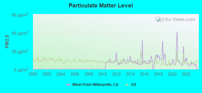
Particulate Matter (PM2.5) [µg/m3] level in 2022 was 6.27. This is better than average. Closest monitor was 20.7 miles away from the city center.
| City: | 6.27 |
| U.S.: | 8.11 |
Earthquake activity:
West Point-Wilseyville-area historical earthquake activity is significantly above California state average. It is 7963% greater than the overall U.S. average.On 4/18/1906 at 13:12:21, a magnitude 7.9 (7.9 UK, Class: Major, Intensity: VIII - XII) earthquake occurred 146.7 miles away from the city center, causing $524,000,000 total damage
On 10/3/1915 at 06:52:48, a magnitude 7.6 (7.6 UK) earthquake occurred 213.3 miles away from West Point-Wilseyville center
On 7/21/1952 at 11:52:14, a magnitude 7.7 (7.7 UK) earthquake occurred 241.9 miles away from the city center, causing $50,000,000 total damage
On 12/21/1932 at 06:10:09, a magnitude 7.2 (7.2 UK) earthquake occurred 122.6 miles away from West Point-Wilseyville center
On 10/18/1989 at 00:04:15, a magnitude 7.1 (6.5 MB, 7.1 MS, 6.9 MW, 7.0 ML) earthquake occurred 115.2 miles away from West Point-Wilseyville center, causing 62 deaths (62 shaking deaths) and 3757 injuries, causing $1,305,032,704 total damage
On 11/4/1927 at 13:51:53, a magnitude 7.5 (7.5 UK) earthquake occurred 239.3 miles away from West Point-Wilseyville center
Magnitude types: body-wave magnitude (MB), local magnitude (ML), surface-wave magnitude (MS), moment magnitude (MW)
Natural disasters:
The number of natural disasters in Calaveras County (17) is near the US average (15).Major Disasters (Presidential) Declared: 8
Emergencies Declared: 2
Causes of natural disasters: Floods: 10, Winter Storms: 7, Mudslides: 5, Fires: 4, Landslides: 3, Storms: 3, Drought: 1, Hurricane: 1, Other: 1 (Note: some incidents may be assigned to more than one category).
Colleges/universities with over 2000 students nearest to West Point-Wilseyville:
- Folsom Lake College (about 49 miles; Folsom, CA; Full-time enrollment: 5,308)
- Sierra College (about 58 miles; Rocklin, CA; FT enrollment: 11,488)
- University of the Pacific (about 59 miles; Stockton, CA; FT enrollment: 4,999)
- San Joaquin Delta College (about 59 miles; Stockton, CA; FT enrollment: 12,167)
- American River College (about 60 miles; Sacramento, CA; FT enrollment: 20,452)
- Modesto Junior College (about 60 miles; Modesto, CA; FT enrollment: 10,635)
- Cosumnes River College (about 60 miles; Sacramento, CA; FT enrollment: 9,327)
Points of interest:
Notable locations in West Point-Wilseyville: Calaveras Ranger Station (A), Camp Wolfeboro (B), Kran (C), McClain (D), Barnett (E), Cooks Ranch (F), Camp Sugar Pine Girl Scout Camp (G), Toutch Mill (H), Cottage Springs Picnic Area (I), Candy Rock (J), Crescent Cove Picnic Area (K), Arnold California Division of Forestry Fire Station (L), Stanislaus River Campground (M), Sand Flat Campground (N), White Azalea Campground (O), Bailey Ridge Forest Service Station (P), Hells Kitchen Vista (Q), Buck Ranch (R), Dardanelles Overlook (S), Dorrington Forest Service Station (T). Display/hide their locations on the map
Shopping Center: Cedar Center Shopping Center (1). Display/hide its location on the map
Churches in West Point-Wilseyville include: Big Trees Community Bible Church (A), First Baptist Church of West Point (B), Saint Claires Episcopal Church (C). Display/hide their locations on the map
Lakes and reservoirs: Lion Lake (A), Clark Reservoir (B), Tiger Creek Reservoir (C), Wilson Lake (D), Snowshoe Lake (E), White Pines Lake (F), Fly in Acres Reservoir (G), Pinebrook Reservoir (H). Display/hide their locations on the map
Streams, rivers, and creeks: North Fork Mokelumne River (A), Jack Nelson Creek (B), Jelmini Creek (C), Lightning Creek (D), Martel Creek (E), Cowell Creek (F), Swamp Creek (G), South Fork Mokelumne River (H), Middle Fork Mokelumne River (I). Display/hide their locations on the map
Parks in West Point-Wilseyville include: Calaveras Big Trees State Park (1), Sandy Gulch Field Baseball Park (2), Sandy Gulch State Historic Landmark (3), West Point State Historic Landmark (4), White Pines Park (5), Leach Field (6). Display/hide their locations on the map
| This place: | 2.3 people |
| California: | 2.9 people |
| This place: | 58.4% |
| Whole state: | 69.4% |
| This place: | 5.6% |
| Whole state: | 5.9% |
Likely homosexual households (counted as self-reported same-sex unmarried-partner households)
- Lesbian couples: 0.4% of all households
- Gay men: 0.2% of all households
| This place: | 13.6% |
| Whole state: | 14.2% |
| This place: | 4.7% |
| Whole state: | 6.3% |
For population 15 years and over in West Point-Wilseyville:
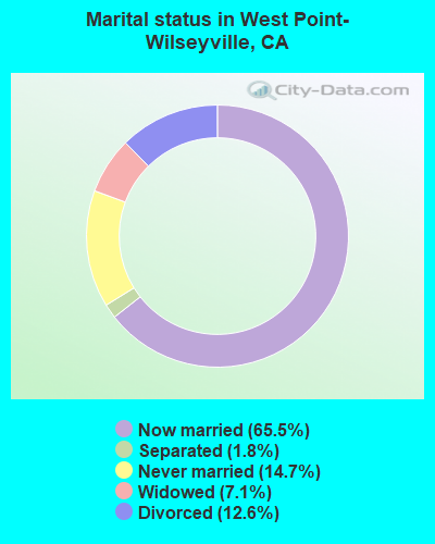
- Never married: 14.7%
- Now married: 65.5%
- Separated: 1.8%
- Widowed: 7.1%
- Divorced: 12.6%
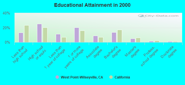
For population 25 years and over in West Point-Wilseyville:
- High school or higher: 86.9%
- Bachelor's degree or higher: 21.4%
- Graduate or professional degree: 7.7%
- Unemployed: 6.8%
- Mean travel time to work (commute): 30.5 minutes
| Here: | 9.8 |
| California average: | 16.1 |
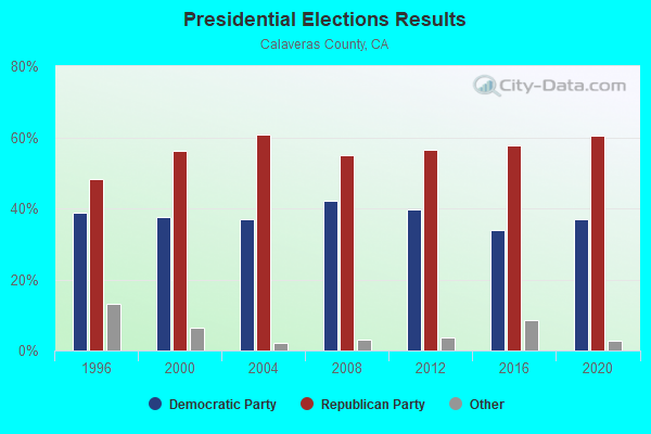
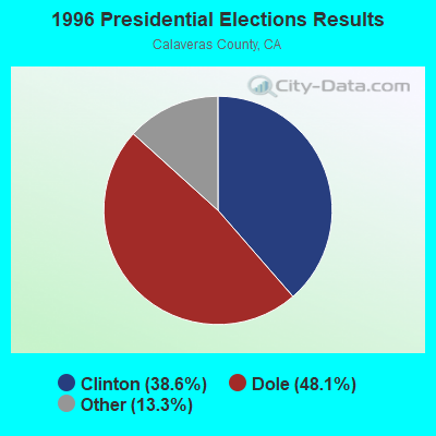
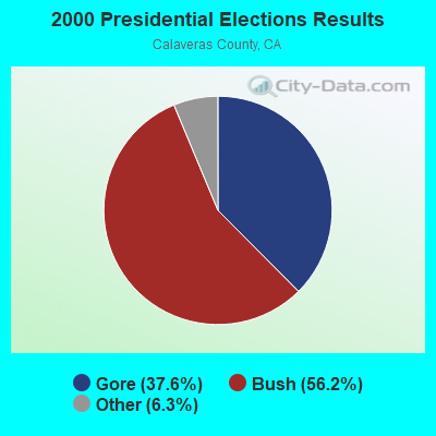
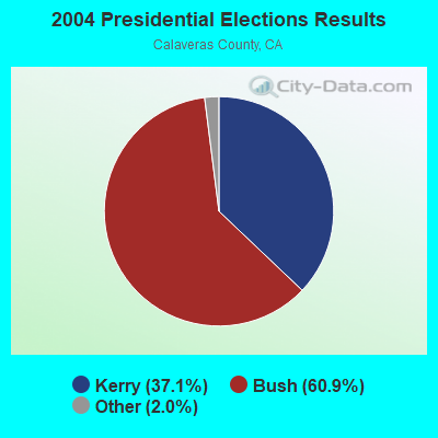
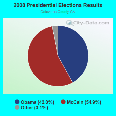
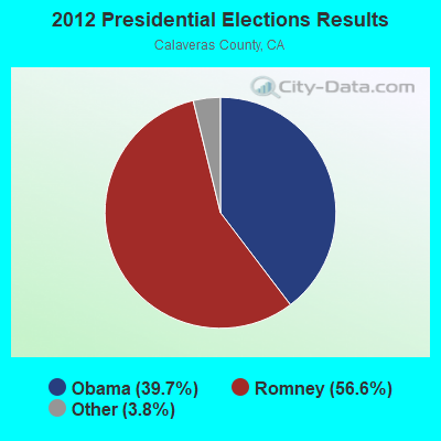
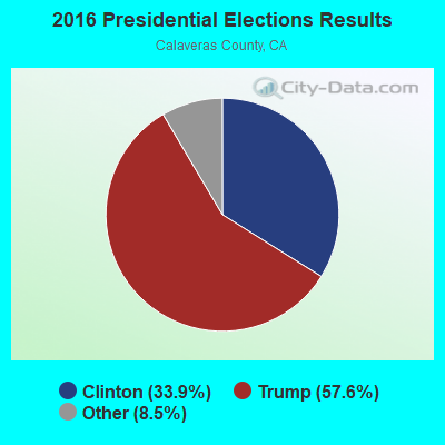

Graphs represent county-level data. Detailed 2008 Election Results
Religion statistics for West Point-Wilseyville, CA (based on Calaveras County data)
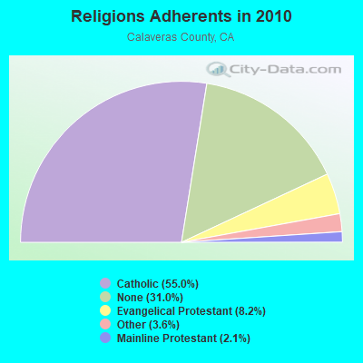
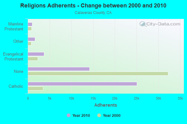
| Religion | Adherents | Congregations |
|---|---|---|
| Catholic | 25,052 | 5 |
| Evangelical Protestant | 3,717 | 40 |
| Other | 1,642 | 6 |
| Mainline Protestant | 972 | 8 |
| Orthodox | 45 | 2 |
| None | 14,150 | - |
Food Environment Statistics:
| Calaveras County: | 2.35 / 10,000 pop. |
| State: | 2.14 / 10,000 pop. |
| This county: | 1.28 / 10,000 pop. |
| State: | 0.62 / 10,000 pop. |
| Here: | 3.85 / 10,000 pop. |
| California: | 1.49 / 10,000 pop. |
| Here: | 9.41 / 10,000 pop. |
| California: | 7.42 / 10,000 pop. |
| Calaveras County: | 7.5% |
| California: | 7.3% |
| This county: | 22.7% |
| State: | 21.3% |
| Here: | 18.8% |
| State: | 17.9% |
Strongest AM radio stations in West Point-Wilseyville:
- KCBC (770 AM; 50 kW; RIVERBANK, CA; Owner: KIERTRON, INC.)
- KHTK (1140 AM; 50 kW; SACRAMENTO, CA; Owner: INFINITY RADIO SUBSIDIARY OPERATIONS INC.)
- KSTE (650 AM; 25 kW; RANCHO CORDOVA, CA; Owner: AMFM RADIO LICENSES, L.L.C.)
- KFIA (710 AM; 25 kW; CARMICHAEL, CA; Owner: VISTA BROADCASTING INC.)
- KFBK (1530 AM; 50 kW; SACRAMENTO, CA; Owner: AMFM RADIO LICENSES, L.L.C.)
- KKOH (780 AM; 50 kW; RENO, NV; Owner: CITADEL BROADCASTING COMPANY)
- KNBR (680 AM; 50 kW; SAN FRANCISCO, CA; Owner: KNBR LICO, INC.)
- KMJ (580 AM; 50 kW; FRESNO, CA; Owner: INFINITY RADIO OPERATIONS INC.)
- KGO (810 AM; 50 kW; SAN FRANCISCO, CA; Owner: KGO-AM RADIO, INC.)
- KCBS (740 AM; 50 kW; SAN FRANCISCO, CA; Owner: INFINITY BROADCASTING OPERATIONS, INC.)
- KTRB (860 AM; 50 kW; MODESTO, CA; Owner: PAPPAS RADIO OF CALIFORNIA, A CALIFORNIA LIMITED PARTNERSHIP)
- KTCT (1050 AM; 50 kW; SAN MATEO, CA; Owner: SUSQUEHANNA RADIO CORP.)
- KFAX (1100 AM; 50 kW; SAN FRANCISCO, CA; Owner: GOLDEN GATE BROADCASTING CO, INC.)
Strongest FM radio stations in West Point-Wilseyville:
- KBYN (95.9 FM; ARNOLD, CA; Owner: KBYN, INC.)
- KCFA (106.1 FM; ARNOLD, CA; Owner: KCFA, INC.)
- KXSR (91.7 FM; GROVELAND, CA; Owner: CALIFORNIA STATE UNIVERSITY, SACRAMENTO)
- KKBN (93.5 FM; TWAIN HARTE, CA; Owner: CLARKE BROADCASTING CORPORATION)
- KCVR-FM (98.9 FM; COLUMBIA, CA; Owner: ENTRAVISION HOLDINGS, LLC)
- KOSL (94.3 FM; JACKSON, CA; Owner: HBC LICENSE CORPORATION)
- KZSQ-FM (92.7 FM; SONORA, CA; Owner: CLARKE BROADCASTING CORPORATION)
- KWYL (102.9 FM; SOUTH LAKE TAHOE, CA; Owner: CITADEL BROADCASTING COMPANY)
- KHOP (95.1 FM; OAKDALE, CA; Owner: CITADEL BROADCASTING COMPANY)
- KSVL (92.3 FM; SMITH, NV; Owner: DONEGAL ENTERPRISES)
- K294AW (106.7 FM; ARNOLD, CA; Owner: KCFA, INC.)
- KTHX-FM (100.1 FM; DAYTON, NV; Owner: NM LICENSING, LLC)
- KRNO (106.9 FM; INCLINE VILLAGE, NV; Owner: AMERICOM LAS VEGAS LIMITED PARTNERSHIP)
- KODS (103.7 FM; CARNELIAN BAY, CA; Owner: AMERICOM, A CALIFORNIA LIMITED PARTNERSHIP)
- KLCA (96.5 FM; TAHOE CITY, CA; Owner: AMERICOM LAS VEGAS LIMITED PARTNERSHIP)
- KKTO (90.5 FM; TAHOE CITY, CA; Owner: CALIFORNIA STATE UNIVERSITY)
- KDOT (104.5 FM; RENO, NV; Owner: LOTUS RADIO CORP.)
- KOZZ-FM (105.7 FM; RENO, NV; Owner: LOTUS RADIO CORP.)
- KEFR (89.9 FM; LE GRAND, CA; Owner: FAMILY STATIONS, INC.)
- KUBB (96.3 FM; MARIPOSA, CA; Owner: BUCKLEY BROADCASTING CORP. OF MONTEREY INC)
TV broadcast stations around West Point-Wilseyville:
- KMMK-LP (Channel 14; SACRAMENTO, CA; Owner: CABALLERO TELEVISION TEXAS, L.L.C.)
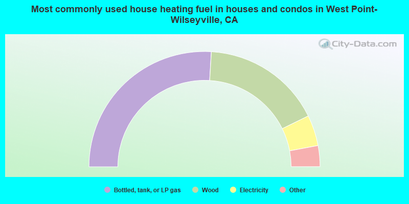
- 51.9%Bottled, tank, or LP gas
- 33.6%Wood
- 8.6%Electricity
- 3.3%Utility gas
- 1.4%Fuel oil, kerosene, etc.
- 1.2%Other fuel
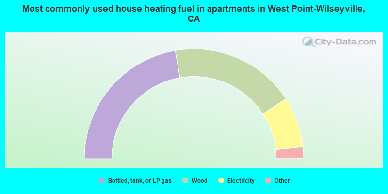
- 44.5%Bottled, tank, or LP gas
- 37.1%Wood
- 14.9%Electricity
- 1.5%Other fuel
- 1.3%Utility gas
- 0.6%Solar energy
West Point-Wilseyville compared to California state average:
- Median house value below state average.
- Unemployed percentage below state average.
- Black race population percentage significantly below state average.
- Hispanic race population percentage significantly below state average.
- Median age significantly above state average.
- Foreign-born population percentage significantly below state average.
- Renting percentage significantly below state average.
- Length of stay since moving in significantly above state average.
- Number of rooms per house significantly below state average.
- House age significantly below state average.
- Institutionalized population percentage significantly above state average.
- Number of college students below state average.
West Point-Wilseyville on our top lists:
- #1 on the list of "Top 101 cities with largest percentage of males in industries: private households (population 5,000+)"
- #5 on the list of "Top 101 cities with largest percentage of females in industries: building material and garden equipment and supplies dealers (population 5,000+)"
- #6 on the list of "Top 101 cities with largest percentage of females in industries: nonmetallic mineral products (population 5,000+)"
- #10 on the list of "Top 101 cities with largest percentage of males in occupations: preschool, kindergarten, elementary and middle school teachers (population 5,000+)"
- #15 on the list of "Top 101 cities with largest percentage of females in industries: beverage and tobacco products (population 5,000+)"
- #17 on the list of "Top 101 cities with largest percentage of females in occupations: art and design workers (population 5,000+)"
- #20 on the list of "Top 101 cities with largest percentage of females in occupations: air transportation workers (population 5,000+)"
- #21 on the list of "Top 101 cities with largest percentage of males in industries: fuel dealers (population 5,000+)"
- #30 on the list of "Top 101 cities with largest percentage of females in industries: private households (population 5,000+)"
- #35 on the list of "Top 101 cities with largest percentage of males in occupations: other health diagnosing and treating practitioners and technical occupations (population 5,000+)"
- #37 on the list of "Top 101 cities with largest percentage of males in occupations: other food preparation and serving workers including supervisors (population 5,000+)"
- #58 on the list of "Top 101 cities with largest percentage of females in industries: food and beverage stores (population 5,000+)"
- #60 on the list of "Top 101 cities with largest percentage of females in occupations: personal appearance workers (population 5,000+)"
- #86 on the list of "Top 101 cities with largest percentage of males in industries: furniture and related product manufacturing (population 5,000+)"
- #96 on the list of "Top 101 cities with largest percentage of females in industries: air transportation (population 5,000+)"
- #98 on the list of "Top 101 counties with the lowest Particulate Matter (PM2.5) Annual air pollution readings in 2012 (µg/m3)"