Temple, New Hampshire
Submit your own pictures of this town and show them to the world
- OSM Map
- General Map
- Google Map
- MSN Map
Population change since 2000: +5.3%
 |
| Males: 681 | |
| Females: 685 |
| Median resident age: | 45.1 years |
| New Hampshire median age: | 43.9 years |
Zip codes: 03086.
| Temple: | $102,578 |
| NH: | $89,992 |
Estimated per capita income in 2022: $43,669 (it was $21,897 in 2000)
Temple town income, earnings, and wages data
Estimated median house or condo value in 2022: $416,823 (it was $138,600 in 2000)
| Temple: | $416,823 |
| NH: | $384,700 |
Mean prices in 2022: all housing units: $411,252; detached houses: $441,251; townhouses or other attached units: $283,002; in 2-unit structures: $347,377; in 3-to-4-unit structures: $666,663; in 5-or-more-unit structures: $275,798; mobile homes: $132,093
Detailed information about poverty and poor residents in Temple, NH


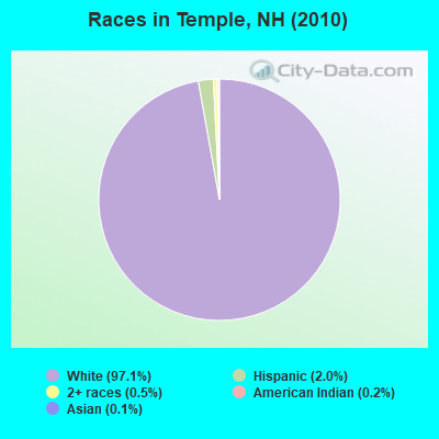
- 1,32697.1%White alone
- 282.0%Hispanic
- 70.5%Two or more races
- 30.2%American Indian alone
- 20.1%Asian alone
Races in Temple detailed stats: ancestries, foreign born residents, place of birth
According to our research of New Hampshire and other state lists, there was 1 registered sex offender living in Temple, New Hampshire as of July 03, 2024.
The ratio of all residents to sex offenders in Temple is 1,366 to 1.
The ratio of registered sex offenders to all residents in this city is much lower than the state average.
 Recent articles from our blog. Our writers, many of them Ph.D. graduates or candidates, create easy-to-read articles on a wide variety of topics.

 | Nice towns in NH (38 replies) |
| Low density housing is killing nh! (67 replies) |
| Jewish Community Manchester (4 replies) |
| Relocate within one hour drive of MHT airport (38 replies) |
| Friendly reminder, New Hampshire Winters (12 replies) |
| Traffic Between Peterborough and Nashua on 101 (1 reply) |
Latest news from Temple, NH collected exclusively by city-data.com from local newspapers, TV, and radio stations
Ancestries: English (27.8%), Irish (15.0%), German (12.3%), French (10.3%), Italian (8.4%), French Canadian (6.9%).
Current Local Time: EST time zone
Incorporated in 1768
Elevation: 1005 feet
Land area: 23.2 square miles.
Population density: 59 people per square mile (very low).
82 residents are foreign born (4.0% Europe, 0.8% Latin America).
| This town: | 6.3% |
| New Hampshire: | 4.4% |
| Temple town: | 2.5% ($3,478) |
| New Hampshire: | 2.3% ($2,946) |
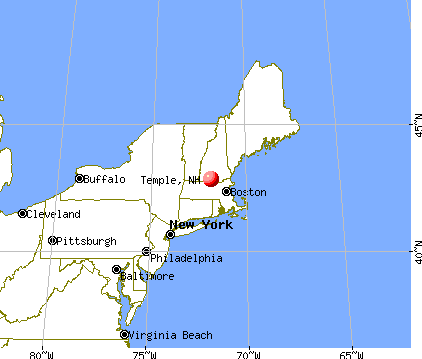
Nearest city with pop. 50,000+: Nashua, NH  (19.4 miles , pop. 86,605).
Nearest city with pop. 200,000+: Boston, MA (51.9 miles , pop. 589,141).
Nearest city with pop. 1,000,000+: Bronx, NY (171.7 miles , pop. 1,332,650).
Nearest cities:
), ), )Latitude: 42.82 N, Longitude: 71.85 W
Area code commonly used in this area: 603

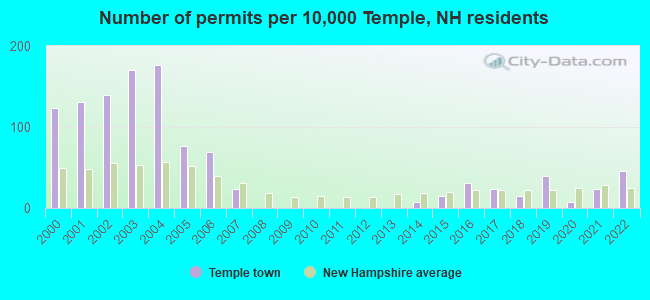
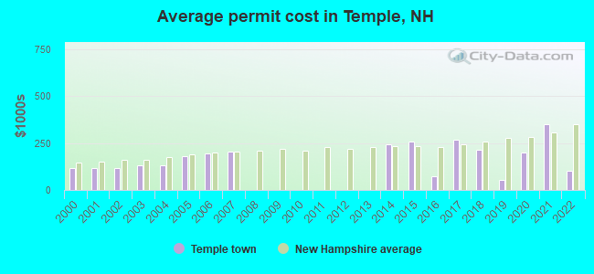
Single-family new house construction building permits:
- 2022: 6 buildings, average cost: $100,000
- 2021: 3 buildings, average cost: $350,000
- 2020: 1 building, cost: $200,000
- 2019: 5 buildings, average cost: $52,900
- 2018: 2 buildings, average cost: $215,500
- 2017: 3 buildings, average cost: $267,800
- 2016: 4 buildings, average cost: $75,000
- 2015: 2 buildings, average cost: $257,200
- 2014: 1 building, cost: $241,400
- 2007: 3 buildings, average cost: $203,800
- 2006: 9 buildings, average cost: $194,900
- 2005: 10 buildings, average cost: $177,500
- 2004: 23 buildings, average cost: $132,800
- 2003: 22 buildings, average cost: $132,800
- 2002: 18 buildings, average cost: $118,000
- 2001: 17 buildings, average cost: $118,000
- 2000: 16 buildings, average cost: $118,000
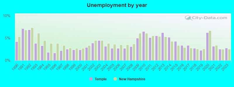
| Here: | 2.8% |
| New Hampshire: | 2.5% |
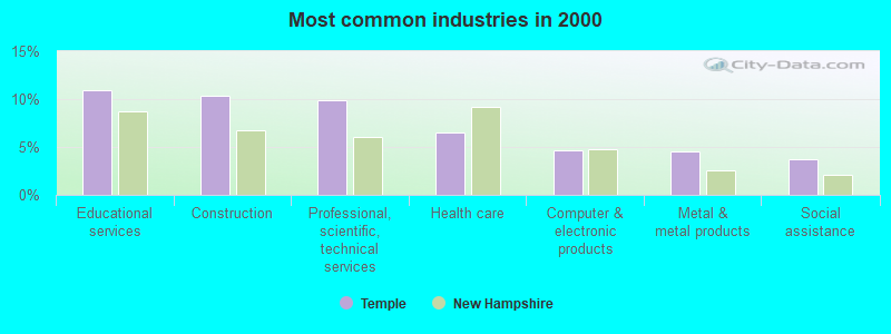
- Educational services (10.9%)
- Construction (10.3%)
- Professional, scientific, technical services (9.9%)
- Health care (6.5%)
- Computer & electronic products (4.7%)
- Metal & metal products (4.5%)
- Social assistance (3.7%)
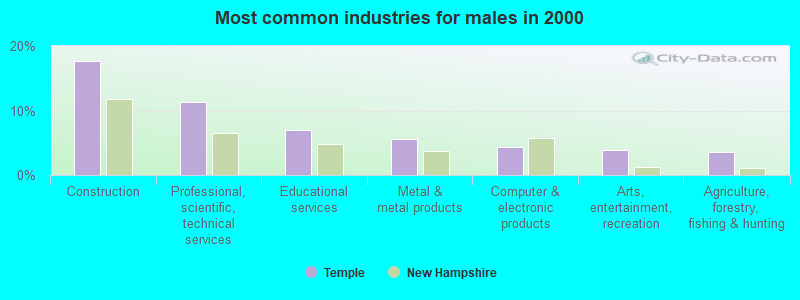
- Construction (17.7%)
- Professional, scientific, technical services (11.3%)
- Educational services (6.9%)
- Metal & metal products (5.6%)
- Computer & electronic products (4.4%)
- Arts, entertainment, recreation (3.8%)
- Agriculture, forestry, fishing & hunting (3.6%)
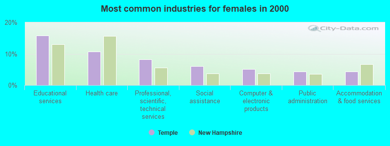
- Educational services (15.8%)
- Health care (10.7%)
- Professional, scientific, technical services (8.2%)
- Social assistance (6.0%)
- Computer & electronic products (5.0%)
- Public administration (4.4%)
- Accommodation & food services (4.4%)
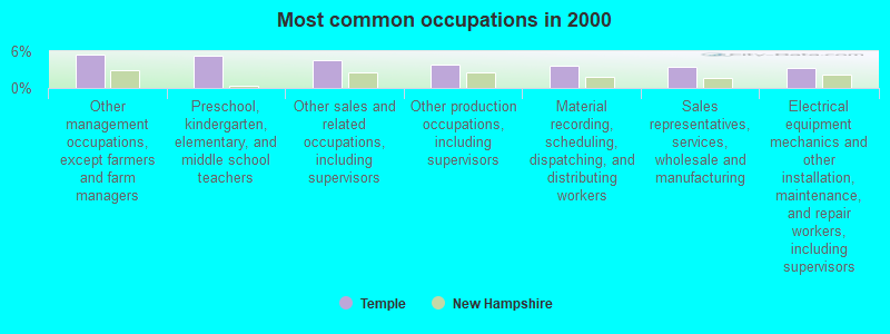
- Other management occupations, except farmers and farm managers (5.4%)
- Preschool, kindergarten, elementary, and middle school teachers (5.2%)
- Other sales and related occupations, including supervisors (4.5%)
- Other production occupations, including supervisors (3.8%)
- Material recording, scheduling, dispatching, and distributing workers (3.7%)
- Sales representatives, services, wholesale and manufacturing (3.4%)
- Electrical equipment mechanics and other installation, maintenance, and repair workers, including supervisors (3.3%)
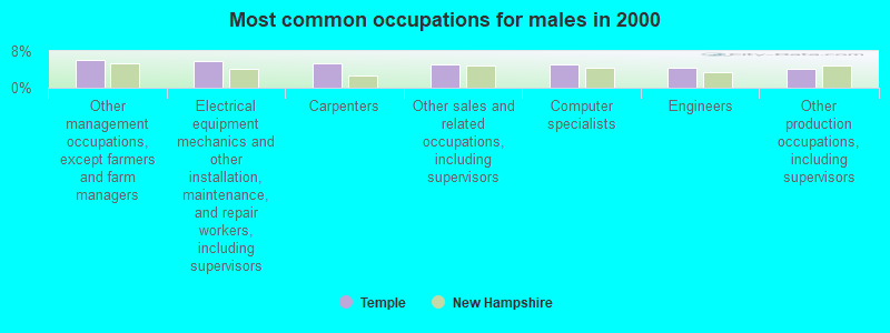
- Other management occupations, except farmers and farm managers (6.2%)
- Electrical equipment mechanics and other installation, maintenance, and repair workers, including supervisors (5.9%)
- Carpenters (5.4%)
- Other sales and related occupations, including supervisors (5.1%)
- Computer specialists (5.1%)
- Engineers (4.4%)
- Other production occupations, including supervisors (4.1%)
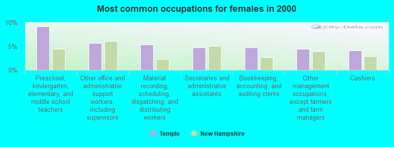
- Preschool, kindergarten, elementary, and middle school teachers (9.1%)
- Other office and administrative support workers, including supervisors (5.7%)
- Material recording, scheduling, dispatching, and distributing workers (5.4%)
- Secretaries and administrative assistants (4.7%)
- Bookkeeping, accounting, and auditing clerks (4.7%)
- Other management occupations, except farmers and farm managers (4.4%)
- Cashiers (4.1%)
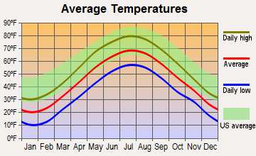
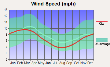
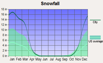
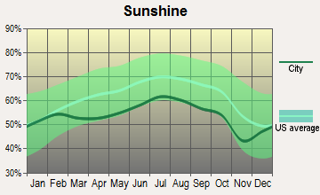
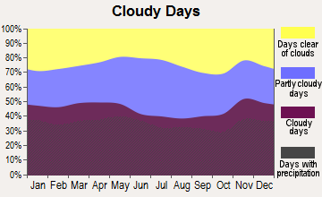
Average climate in Temple, New Hampshire
Based on data reported by over 4,000 weather stations
(lower is better)
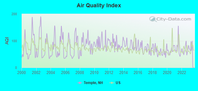
Air Quality Index (AQI) level in 2022 was 66.8. This is about average.
| City: | 66.8 |
| U.S.: | 72.6 |
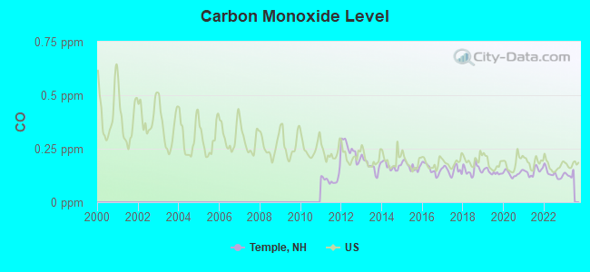
Carbon Monoxide (CO) [ppm] level in 2022 was 0.132. This is significantly better than average. Closest monitor was 3.3 miles away from the city center.
| City: | 0.132 |
| U.S.: | 0.251 |
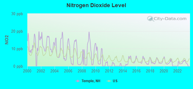
Nitrogen Dioxide (NO2) [ppb] level in 2022 was 2.05. This is significantly better than average. Closest monitor was 3.3 miles away from the city center.
| City: | 2.05 |
| U.S.: | 5.11 |
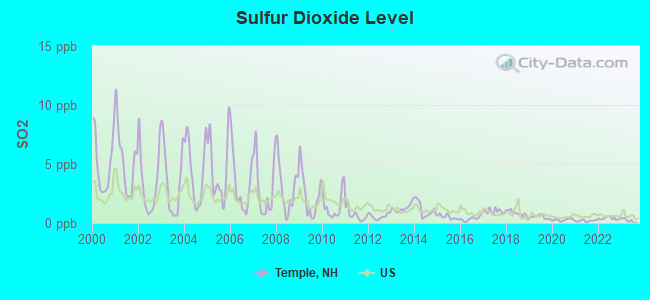
Sulfur Dioxide (SO2) [ppb] level in 2022 was 0.396. This is significantly better than average. Closest monitor was 3.3 miles away from the city center.
| City: | 0.396 |
| U.S.: | 1.515 |
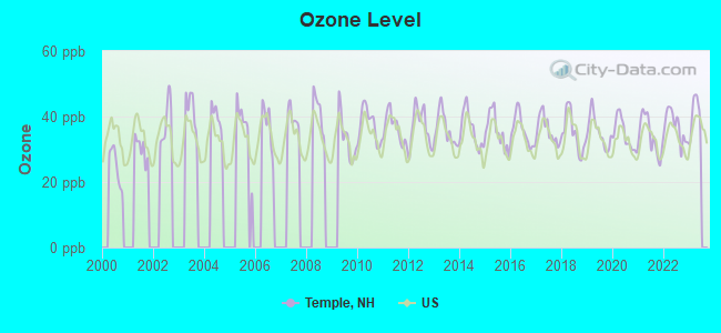
Ozone [ppb] level in 2022 was 37.0. This is about average. Closest monitor was 3.3 miles away from the city center.
| City: | 37.0 |
| U.S.: | 33.3 |
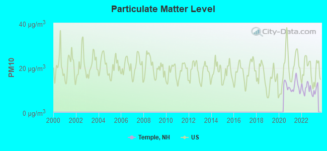
Particulate Matter (PM10) [µg/m3] level in 2022 was 10.6. This is significantly better than average. Closest monitor was 3.3 miles away from the city center.
| City: | 10.6 |
| U.S.: | 19.2 |
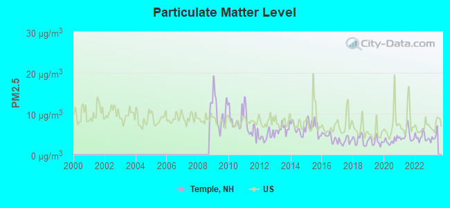
Particulate Matter (PM2.5) [µg/m3] level in 2022 was 4.25. This is significantly better than average. Closest monitor was 3.3 miles away from the city center.
| City: | 4.25 |
| U.S.: | 8.11 |
Tornado activity:
Temple-area historical tornado activity is above New Hampshire state average. It is 25% smaller than the overall U.S. average.
On 6/9/1953, a category F4 (max. wind speeds 207-260 mph) tornado 29.1 miles away from the Temple town center killed 90 people and injured 1228 people and caused between $50,000,000 and $500,000,000 in damages.
On 6/22/1981, a category F3 (max. wind speeds 158-206 mph) tornado 18.8 miles away from the town center injured 3 people and caused between $5000 and $50,000 in damages.
Earthquake activity:
Temple-area historical earthquake activity is significantly above New Hampshire state average. It is 71% smaller than the overall U.S. average.On 10/7/1983 at 10:18:46, a magnitude 5.3 (5.1 MB, 5.3 LG, 5.1 ML, Class: Moderate, Intensity: VI - VII) earthquake occurred 147.7 miles away from Temple center
On 4/20/2002 at 10:50:47, a magnitude 5.3 (5.3 ML, Depth: 3.0 mi) earthquake occurred 149.1 miles away from Temple center
On 4/20/2002 at 10:50:47, a magnitude 5.2 (5.2 MB, 4.2 MS, 5.2 MW, 5.0 MW) earthquake occurred 148.4 miles away from Temple center
On 1/19/1982 at 00:14:42, a magnitude 4.7 (4.5 MB, 4.7 MD, 4.5 LG, Class: Light, Intensity: IV - V) earthquake occurred 48.7 miles away from the city center
On 10/16/2012 at 23:12:25, a magnitude 4.7 (4.7 ML, Depth: 10.0 mi) earthquake occurred 80.8 miles away from the city center
On 10/2/1994 at 11:27:22, a magnitude 3.7 (3.5 LG, 3.7 LG, Depth: 6.2 mi, Class: Light, Intensity: II - III) earthquake occurred 39.2 miles away from Temple center
Magnitude types: regional Lg-wave magnitude (LG), body-wave magnitude (MB), duration magnitude (MD), local magnitude (ML), surface-wave magnitude (MS), moment magnitude (MW)
Natural disasters:
The number of natural disasters in Hillsborough County (27) is a lot greater than the US average (15).Major Disasters (Presidential) Declared: 17
Emergencies Declared: 10
Causes of natural disasters: Storms: 13, Floods: 11, Winter Storms: 5, Snowstorms: 4, Hurricanes: 3, Snows: 3, Blizzard: 1, Ice Storm: 1, Snowfall: 1, Wind: 1 (Note: some incidents may be assigned to more than one category).
Hospitals and medical centers near Temple:
- MONADNOCK COMMUNITY HOSPITAL Critical Access Hospitals (about 7 miles away; PETERBOROUGH, NH)
- PHEASANT WOOD CARE AND REHABILIATION CENTER (Nursing Home, about 8 miles away; PETERBOROUGH, NH)
- GOOD SHEPHERD REHABILITATION AND NURSING CENTER (Nursing Home, about 9 miles away; JAFFREY, NH)
- CRESTWOOD CARE AND REHABILITATION CENTER (Nursing Home, about 10 miles away; MILFORD, NH)
- ST JOSEPH HOME AND HOSPICE CARE (Home Health Center, about 10 miles away; MILFORD, NH)
- ELM'S NURSING AND REHAB CENTER (THE) (Nursing Home, about 10 miles away; MILFORD, NH)
- NAUKEAG HOSPITAL CORPORATION (Hospital, about 12 miles away; ASHBURNHAM, MA)
Heliports located in Temple:
Colleges/universities with over 2000 students nearest to Temple:
- Franklin Pierce University (about 11 miles; Rindge, NH; Full-time enrollment: 2,139)
- Fitchburg State University (about 17 miles; Fitchburg, MA; FT enrollment: 5,010)
- Mount Wachusett Community College (about 18 miles; Gardner, MA; FT enrollment: 3,143)
- Saint Anselm College (about 21 miles; Manchester, NH; FT enrollment: 2,059)
- Mount Washington College (about 22 miles; Manchester, NH; FT enrollment: 2,187)
- Keene State College (about 24 miles; Keene, NH; FT enrollment: 5,098)
- Southern New Hampshire University (about 26 miles; Manchester, NH; FT enrollment: 16,552)
Public elementary/middle school in Temple:
- TEMPLE ELEMENTARY SCHOOL (Students: 60, Location: 830 NH ROUTE 45, Grades: KG-4)
User-submitted facts and corrections:
- Temple Elementary School is no longer on Hadley Hwy. A new school was built several years ago... http://www.conval.edu/Schools/tes/index.htm added by Temple Resident
Points of interest:
Notable locations in Temple: Miller Grange (A), Temple Mountain Ski Area (B), Temple Volunteer Fire Department (C), Solon Mansfield Memorial Library (D), Temple Town Hall (E). Display/hide their locations on the map
Church in Temple: Temple Congregational Church (A). Display/hide its location on the map
Cemetery: Miler Cemetery (1). Display/hide its location on the map
Lakes and reservoirs: Caswell Pond (A), Greenville Reservoir (B). Display/hide their locations on the map
Birthplace of: Henry Ames Blood - Civil servant, Daniel Pratt (industrialist) - Civil War industrialist.
Drinking water stations with addresses in Temple and their reported violations in the past:
PONY FARM (Population served: 75, Groundwater):Past monitoring violations:
- Monitoring, Repeat Major (TCR) - Between APR-2009 and JUN-2009, Contaminant: Coliform (TCR). Follow-up actions: St Violation/Reminder Notice (JUL-16-2009), St Public Notif requested (JUL-16-2009), St Compliance achieved (JUL-24-2009), St Public Notif received (JUN-16-2010)
- 3 routine major monitoring violations
| This town: | 2.6 people |
| New Hampshire: | 2.5 people |
| This town: | 74.6% |
| Whole state: | 66.3% |
| This town: | 9.1% |
| Whole state: | 8.3% |
Likely homosexual households (counted as self-reported same-sex unmarried-partner households)
- Lesbian couples: 0.6% of all households
- Gay men: 0.6% of all households
| This town: | 6.4% |
| Whole state: | 6.5% |
| This town: | 4.0% |
| Whole state: | 2.8% |
12 people in residential treatment centers for adults in 2010
18 people in homes for the mentally retarded in 2000
For population 15 years and over in Temple:
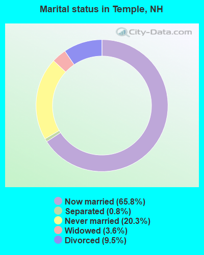
- Never married: 20.3%
- Now married: 65.8%
- Separated: 0.8%
- Widowed: 3.6%
- Divorced: 9.5%
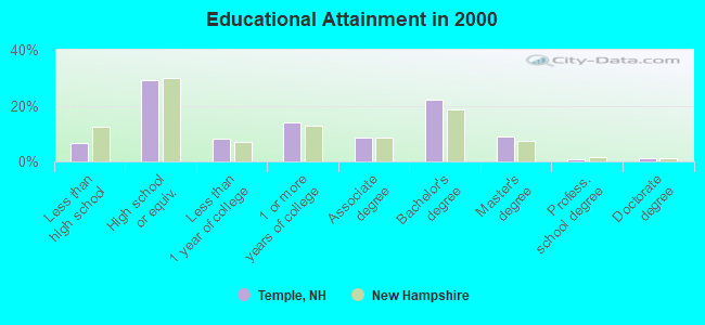
For population 25 years and over in Temple:
- High school or higher: 93.2%
- Bachelor's degree or higher: 32.9%
- Graduate or professional degree: 10.7%
- Unemployed: 4.2%
- Mean travel time to work (commute): 29.4 minutes
| Here: | 10.5 |
| New Hampshire average: | 10.9 |


Graphs represent county-level data. Detailed 2008 Election Results
Religion statistics for Temple, NH (based on Hillsborough County data)


| Religion | Adherents | Congregations |
|---|---|---|
| Catholic | 124,993 | 40 |
| Evangelical Protestant | 20,588 | 103 |
| Mainline Protestant | 17,794 | 60 |
| Other | 7,365 | 35 |
| Orthodox | 2,990 | 7 |
| Black Protestant | - | 1 |
| None | 226,991 | - |
Food Environment Statistics:
| This county: | 1.82 / 10,000 pop. |
| New Hampshire: | 2.14 / 10,000 pop. |
| Hillsborough County: | 0.12 / 10,000 pop. |
| New Hampshire: | 0.15 / 10,000 pop. |
| Here: | 1.65 / 10,000 pop. |
| State: | 1.78 / 10,000 pop. |
| Hillsborough County: | 2.67 / 10,000 pop. |
| New Hampshire: | 4.02 / 10,000 pop. |
| This county: | 8.23 / 10,000 pop. |
| New Hampshire: | 9.70 / 10,000 pop. |
| Hillsborough County: | 6.9% |
| New Hampshire: | 7.6% |
| Hillsborough County: | 24.5% |
| New Hampshire: | 24.4% |
| Here: | 15.1% |
| New Hampshire: | 15.9% |
6.73% of this county's 2021 resident taxpayers lived in other counties in 2020 ($92,767 average adjusted gross income)
| Here: | 6.73% |
| New Hampshire average: | 7.66% |
0.01% of residents moved from foreign countries ($183 average AGI)
Hillsborough County: 0.01% New Hampshire average: 0.01%
Top counties from which taxpayers relocated into this county between 2020 and 2021:
| from Middlesex County, MA | |
| from Rockingham County, NH | |
| from Merrimack County, NH |
6.49% of this county's 2020 resident taxpayers moved to other counties in 2021 ($81,100 average adjusted gross income)
| Here: | 6.49% |
| New Hampshire average: | 6.80% |
0.02% of residents moved to foreign countries ($105 average AGI)
Hillsborough County: 0.02% New Hampshire average: 0.01%
Top counties to which taxpayers relocated from this county between 2020 and 2021:
| to Rockingham County, NH | |
| to Merrimack County, NH | |
| to Middlesex County, MA |
Strongest AM radio stations in Temple:
- WRKO (680 AM; 50 kW; BOSTON, MA; Owner: ENTERCOM BOSTON LICENSE, LLC)
- WCRN (830 AM; 50 kW; WORCESTER, MA; Owner: CARTER BROADCASTING CORPORATION)
- WEEI (850 AM; 50 kW; BOSTON, MA; Owner: ENTERCOM BOSTON LICENSE, LLC)
- WKOX (1200 AM; 50 kW; FRAMINGHAM, MA; Owner: CAPSTAR TX LIMITED PARTNERSHIP)
- WBIX (1060 AM; 40 kW; NATICK, MA; Owner: LANGER BROADCASTING CORPORATION)
- WVNE (760 AM; daytime; 25 kW; LEICESTER, MA; Owner: BLOUNT MASSCOM, INC.)
- WNNZ (640 AM; 50 kW; WESTFIELD, MA; Owner: CLEAR CHANNEL BROADCASTING LICENSES, INC.)
- WWZN (1510 AM; 50 kW; BOSTON, MA; Owner: ROSE CITY RADIO CORPORATION)
- WEIM (1280 AM; 5 kW; FITCHBURG, MA; Owner: LIVEAIR COMMUNICATIONS, INC.)
- WGIR (610 AM; 5 kW; MANCHESTER, NH; Owner: CAPSTAR TX LIMITED PARTNERSHIP)
- WAMG (890 AM; 25 kW; DEDHAM, MA; Owner: MEGA COMMUNICATIONS OF DEDHAM LICENSEE, LLC)
- WALE (990 AM; 50 kW; GREENVILLE, RI; Owner: NORTH AMERICAN BROADCASTING CO., INC.)
- WBZ (1030 AM; 50 kW; BOSTON, MA; Owner: INFINITY BROADCASTING OPERATIONS, INC.)
Strongest FM radio stations in Temple:
- WFEX (92.1 FM; PETERBOROUGH, NH; Owner: FNX BROADCASTING OF NEW HAMPSHIRE LLC)
- WGIR-FM (101.1 FM; MANCHESTER, NH; Owner: CAPSTAR TX LIMITED PARTNERSHIP)
- WQLL (96.5 FM; BEDFORD, NH; Owner: SAGA COMMUNICATIONS OF NEW ENGLAND, LLC)
- WLMW (90.7 FM; MANCHESTER, NH; Owner: KNOWLEDGE FOR LIFE)
- WZID (95.7 FM; MANCHESTER, NH; Owner: SAGA COMMUNICATIONS OF NEW ENGLAND, LLC)
- WINQ (97.7 FM; WINCHENDON, MA; Owner: SAGA COMMUNICATIONS OF NEW ENGLAND, LLC)
- WHDQ (106.1 FM; CLAREMONT, NH; Owner: GREAT NORTHERN RADIO, L.L.C.)
- WTPL (107.7 FM; HILLSBORO, NH; Owner: CONCORD BROADCASTING, L.L.C.)
- WXLO (104.5 FM; FITCHBURG, MA; Owner: CITADEL BROADCASTING COMPANY)
- WVPR (89.5 FM; WINDSOR, VT; Owner: VERMONT PUBLIC RADIO)
- WKNE (103.7 FM; KEENE, NH; Owner: SAGA COMMUNICATIONS OF NEW ENGLAND, LLC)
- WEVN (90.7 FM; KEENE, NH; Owner: NEW HAMPSHIRE PUBLIC RADIO, INC.)
- WNNH (99.1 FM; HENNIKER, NH; Owner: TELE-MEDIA COMPANY OF NEW HAMPSHIRE, L.L.C.)
- WAAF (107.3 FM; WORCESTER, MA; Owner: ENTERCOM BOSTON LICENSE, LLC)
- WEQX (102.7 FM; MANCHESTER, VT; Owner: NORTHSHIRE COMMUNICATIONS, INC.)
- WJAN (95.1 FM; SUNDERLAND, VT; Owner: 6 JOHNSON ROAD LICENSES, INC.)
- WHOB (106.3 FM; NASHUA, NH; Owner: TELE-MEDIA COMPANY OF NEW HAMPSHIRE, L.L.C.)
- W293AB (106.5 FM; KEENE, NH; Owner: GREAT NORTHERN RADIO, L.L.C.)
- WSRS (96.1 FM; WORCESTER, MA; Owner: CAPSTAR TX LIMITED PARTNERSHIP)
- WOQL (98.7 FM; WINCHESTER, NH; Owner: SAGA COMMUNICATIONS OF NEW HAMPSHIRE, LLC)
TV broadcast stations around Temple:
- WUNI (Channel 27; WORCESTER, MA; Owner: ENTRAVISION HOLDINGS, LLC)
- WUTF (Channel 66; MARLBOROUGH, MA; Owner: TELEFUTURA BOSTON LLC)
- WCVB-TV (Channel 5; BOSTON, MA; Owner: WCVB HEARST-ARGYLE TV, INC.)
- WGBH-TV (Channel 2; BOSTON, MA; Owner: WGBH EDUCATIONAL FOUNDATION)
- WMFP (Channel 62; LAWRENCE, MA; Owner: WSAH LICENSE, INC.)
- WBZ-TV (Channel 4; BOSTON, MA; Owner: VIACOM INC.)
- WGBX-TV (Channel 44; BOSTON, MA; Owner: WGBH EDUCATIONAL FOUNDATION)
- WFXZ-CA (Channel 24; BOSTON, MA; Owner: BOSTON BROADCASTING CORP.)
- WSBK-TV (Channel 38; BOSTON, MA; Owner: VIACOM INC.)
- WLVI-TV (Channel 56; CAMBRIDGE, MA; Owner: WLVI, INC.)
- WNDS (Channel 50; DERRY, NH; Owner: CTV OF DERRY, INC)
- WFXT (Channel 25; BOSTON, MA; Owner: FOX TELEVISION STATIONS INC.)
- WMUR-TV (Channel 9; MANCHESTER, NH; Owner: HEARST-ARGYLE PROPERTIES, INC.)
- WEKW-TV (Channel 52; KEENE, NH; Owner: UNIVERSITY OF NEW HAMPSHIRE)
- Temple, New Hampshire
- Fatal accident count13
- Vehicles involved in fatal accidents22
- Fatal accidents involving drunk persons:5
- Fatalities15
- Persons involved in fatal accidents38
- Pedestrians involved in fatal accidents0
- New Hampshire average
- Fatal accident count1304
- Vehicles involved in fatal accidents1886
- Fatal accidents involving drunk persons614
- Fatalities1422
- Persons involved in fatal accidents3114
- Pedestrians involved in fatal accidents96
- National Bridge Inventory (NBI) Statistics
- 7Number of bridges
- 20ft / 5.7mTotal length
- $21,994,000Total costs
- 15,415Total average daily traffic
- 1,058Total average daily truck traffic
- 22,810Total future (year 2042) average daily traffic
FCC Registered Cell Phone Towers:
1 (See the full list of FCC Registered Cell Phone Towers in Temple)FCC Registered Antenna Towers:
10 (See the full list of FCC Registered Antenna Towers)FCC Registered Private Land Mobile Towers:
2- Old Peterborough Rd (Lat: 42.826750 Lon: -71.880917), Type: Tower, Structure height: 55 m, Call Sign: WPDA985,
Assigned Frequencies: 929.562 MHz, Grant Date: 12/27/2000, Expiration Date: 08/24/2010, Cancellation Date: 08/10/2001, Registrant: Wilkinson, Barker, Knauer LLP, 2300 N Street N.W., Suite 700, Washington, DC 20037-1128, Phone: (202) 783-4141, Fax: (202) 783-5851, Email:
- Old Peterborough Rd (Lat: 42.826750 Lon: -71.880917), Type: Tower, Structure height: 55 m, Call Sign: WPDF978,
Assigned Frequencies: 929.612 MHz, Grant Date: 09/27/1998, Expiration Date: 09/27/2008, Cancellation Date: 08/10/2001, Registrant: Wilkinson, Barker, Knauer LLP, 2300 N Street N.W., Suite 700, Washington, DC 20037-1128, Phone: (202) 783-4141, Fax: (202) 783-5851, Email:
FCC Registered Microwave Towers:
2- TEMPLE MTN, Old Peterborough Road (Lat: 42.828139 Lon: -71.878944), Type: Tower, Structure height: 55.5 m, Overall height: 57.3 m, Call Sign: WMM394,
Assigned Frequencies: 11645.0 MHz, 10583.1 MHz, Grant Date: 01/25/2011, Expiration Date: 02/01/2021, Cancellation Date: 02/25/2014, Registrant: Verizon Wireless, 1120 Sanctuary Pkwy, #150 Gasa5reg, Alpharetta, GA 30009-7630, Phone: (770) 797-1070, Fax: (770) 797-1036, Email:
- PacGBF, Lat: 42.861333 Lon: -71.879056, Type: Nnltann, Structure height: 30.5 m, Overall height: 37.8 m, Call Sign: WQJY203,
Assigned Frequencies: 3650.00 MHz, Grant Date: 02/10/2009, Expiration Date: 02/10/2019, Cancellation Date: 04/13/2019, Certifier: Marc Spinale, Registrant: Radius North LLC, 3 Clark Farm Rd, Hancock, NH 03449, Phone: (603) 209-5640, Email:
FCC Registered Paging Towers:
2- Old Peterborough Road (Lat: 42.826667 Lon: -71.881389), Type: Tower, Structure height: 55 m, Overall height: 58 m, Call Sign: KNLW542, Licensee ID: L01422065,
Assigned Frequencies: 931.687 MHz, Grant Date: 05/05/2009, Expiration Date: 04/01/2019, Cancellation Date: 02/18/2014, Certifier: Shawn E Endsley, Registrant: Usa Mobility Wireless, Inc., 3000 Technology Dr. #400, Plano, TX 75074, Phone: (972) 801-0000, Email:
- Old Peterborough Road (Lat: 42.826667 Lon: -71.881389), Type: Tower, Structure height: 54.9 m, Overall height: 57.9 m, Call Sign: KNKG813, Licensee ID: L01422065,
Assigned Frequencies: 931.812 MHz, Grant Date: 05/05/2009, Expiration Date: 04/01/2019, Cancellation Date: 01/28/2014, Certifier: Shawn E Endsley, Registrant: Usa Mobility Wireless, Inc., 3000 Technology Dr. #400, Plano, TX 75074, Phone: (972) 801-0000, Fax: (972) 801-1699, Email:
FCC Registered Amateur Radio Licenses:
15 (See the full list of FCC Registered Amateur Radio Licenses in Temple)FAA Registered Aircraft:
2- Aircraft: PIPER PA-24-250 (Category: Land, Seats: 4, Weight: Up to 12,499 Pounds, Speed: 135 mph), Engine: LYCOMING 0-540 SERIES (250 HP) (Reciprocating)
N-Number: 6465P, N6465P, N-6465P, Serial Number: 24-1580, Year manufactured: 1959, Airworthiness Date: 12/03/1959, Certificate Issue Date: 04/17/2003
Registrant (Corporation): Six Five Papa Inc, 18 West Rd, Temple, NH 03084 - Aircraft: EZELL WILLIAM J ROTORWAY EXEC 90 (Category: Land, Seats: 2, Weight: Up to 12,499 Pounds), Engine: AMA/EXPR UNKNOWN ENG (Reciprocating)
N-Number: 4284J, N4284J, N-4284J, Serial Number: 5032, Airworthiness Date: 08/28/1991, Certificate Issue Date: 06/17/1991
Registrant (Individual): William J Ezell, 47 Mountain View Rd, Temple, NH 03084
Deregistered: Cancel Date: 04/19/2018
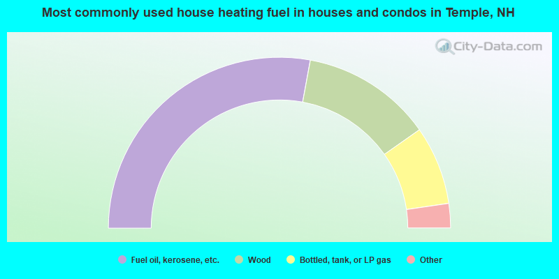
- 55.8%Fuel oil, kerosene, etc.
- 24.7%Wood
- 14.9%Bottled, tank, or LP gas
- 3.8%Electricity
- 0.8%Solar energy
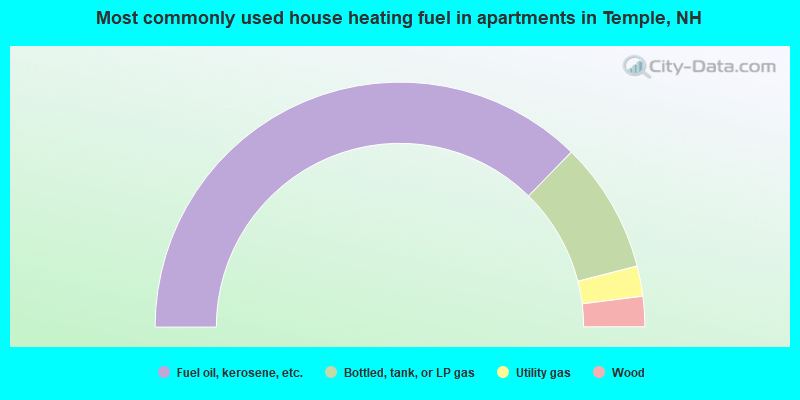
- 74.7%Fuel oil, kerosene, etc.
- 17.3%Bottled, tank, or LP gas
- 4.0%Utility gas
- 4.0%Wood
Temple compared to New Hampshire state average:
- Unemployed percentage below state average.
- Black race population percentage significantly below state average.
- Hispanic race population percentage below state average.
- Renting percentage below state average.
- Length of stay since moving in significantly above state average.
- Number of rooms per house significantly below state average.
- House age significantly below state average.
Temple on our top lists:
- #97 on the list of "Top 101 cities with the largest percentage of people in homes for the mentally retarded (population 1,000+)"
- #6 on the list of "Top 101 counties with the lowest Particulate Matter (PM10) Annual air pollution readings in 2012 (µg/m3)"
- #12 on the list of "Top 101 counties with the lowest Particulate Matter (PM2.5) Annual air pollution readings in 2012 (µg/m3)"
- #15 on the list of "Top 101 counties with the lowest number of infant deaths per 1000 residents 2007-2013 (pop. 50,000+)"
- #24 on the list of "Top 101 counties with the largest decrease in the number of infant deaths per 1000 residents 2000-2006 to 2007-2013 (pop. 50,000+)"
- #44 on the list of "Top 101 counties with the lowest Nitrogen Dioxide air pollution readings in 2012 (ppm)"

|
|
Total of 58 patent applications in 2008-2024.