South Tulsa, Oklahoma

Submit your own pictures of this place and show them to the world
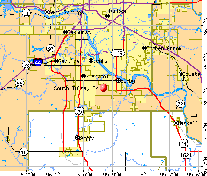
- OSM Map
- General Map
- Google Map
- MSN Map
| Males: 8,432 | |
| Females: 8,945 |
| Median resident age: | 32.3 years |
| Oklahoma median age: | 35.5 years |
Zip code: 74008
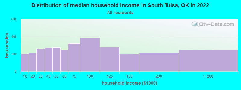
| South Tulsa: | $72,189 |
| OK: | $59,673 |
Estimated per capita income in 2022: $32,806 (it was $18,936 in 2000)
South Tulsa CCD income, earnings, and wages data
Estimated median house or condo value in 2022: $195,869 (it was $75,300 in 2000)
| South Tulsa: | $195,869 |
| OK: | $191,700 |
Mean prices in 2022: all housing units: $279,384; detached houses: $288,634; townhouses or other attached units: $191,026; in 2-unit structures: $95,287; in 3-to-4-unit structures: $148,427; in 5-or-more-unit structures: $210,375; mobile homes: $78,973; occupied boats, rvs, vans, etc.: $15,180
Detailed information about poverty and poor residents in South Tulsa, OK
Compare current foreclosures near South Tulsa, OK:
| Photo | Address | Area | Beds / Baths | Price | Details |
|---|---|---|---|---|---|

|
#1
W Decatur St
Broken Arrow, OK 74011
|
1,678 sq. feet
|
2 baths 3 beds |
$174,900
|
show details |

|
#2
S. 80th East Ave 27d
Tulsa, OK 74133
|
1,030 sq. feet
|
2 baths 1 beds |
$46,500
|
show details |

|
#3
E Lansing St
Broken Arrow, OK 74014
|
- sq. feet
|
2 baths 3 beds |
show details | |

|
#4
W 42nd St
Tulsa, OK 74107
|
768 sq. feet
|
1 baths 2 beds |
show details | |

|
#5
N 220 Rd
Beggs, OK 74421
|
1,352 sq. feet
|
2 baths 3 beds |
show details | |

|
#6
S 107th East Ave
Tulsa, OK 74128
|
1,022 sq. feet
|
1 baths 2 beds |
show details | |

|
#7
S Granite Ave
Tulsa, OK 74136
|
2,412 sq. feet
|
2 baths 3 beds |
show details | |

|
#8
E 30th Pl
Tulsa, OK 74114
|
1,540 sq. feet
|
1 baths 3 beds |
show details | |

|
#9
73rd East Ave
Tulsa, OK 74133
|
2,886 sq. feet
|
3 baths 4 beds |
show details | |

|
#10
S 97th West Ave
Sapulpa, OK 74066
|
1,494 sq. feet
|
2 baths 3 beds |
show details |
| Photo | Address | Area | Beds / Baths | Price | Details |
|---|---|---|---|---|---|

|
#11
W Easton St
Tulsa, OK 74127
|
1,395 sq. feet
|
2 baths 4 beds |
show details | |

|
#12
S 45th West Ave
Tulsa, OK 74127
|
1,176 sq. feet
|
1 baths 3 beds |
show details | |

|
#13
W Vicksburg St
Broken Arrow, OK 74011
|
1,846 sq. feet
|
2 baths 4 beds |
show details | |

|
#14
S Maybelle Ave
Tulsa, OK 74107
|
1,500 sq. feet
|
2 baths 3 beds |
show details | |

|
#15
S Ash Ct
Broken Arrow, OK 74012
|
1,627 sq. feet
|
2 baths 3 beds |
show details | |

|
#16
E 105th Ct
Tulsa, OK 74133
|
4,335 sq. feet
|
3 baths 4 beds |
show details | |

|
#17
E 24th Pl
Tulsa, OK 74114
|
1,036 sq. feet
|
1 baths 2 beds |
show details | |

|
#18
S 142nd East Ave
Tulsa, OK 74108
|
1,583 sq. feet
|
2 baths 3 beds |
show details | |

|
#19
N Main St
Sapulpa, OK 74066
|
1,494 sq. feet
|
2 baths 3 beds |
show details | |

|
#20
S 111th East Ave
Tulsa, OK 74133
|
1,963 sq. feet
|
2 baths 3 beds |
show details |
| Photo | Address | Area | Beds / Baths | Price | Details |
|---|---|---|---|---|---|

|
#21
Los Angeles St
Broken Arrow, OK 74011
|
1,438 sq. feet
|
2 baths 3 beds |
show details | |

|
#22
W Quantico St
Broken Arrow, OK 74011
|
1,376 sq. feet
|
1 baths 3 beds |
show details | |

|
#23
W 182nd St S
Mounds, OK 74047
|
1,792 sq. feet
|
2 baths 4 beds |
show details | |

|
#24
139th E Ave
Tulsa, OK 74134
|
1,708 sq. feet
|
2 baths 3 beds |
show details | |

|
#25
E Archer St
Tulsa, OK 74115
|
- sq. feet
|
- baths - beds |
$26,900
|
show details |

|
#26
S Elm St
Sapulpa, OK 74066
|
1,286 sq. feet
|
1 baths 3 beds |
show details | |

|
#27
S 68th East Ave
Tulsa, OK 74133
|
3,890 sq. feet
|
3 baths - beds |
show details | |

|
#28
E 103rd St
Tulsa, OK 74133
|
3,579 sq. feet
|
3 baths 4 beds |
show details | |

|
#29
E 86th St S
Broken Arrow, OK 74014
|
1,558 sq. feet
|
2 baths 4 beds |
show details | |

|
#30
S Cedar St
Sapulpa, OK 74066
|
1,128 sq. feet
|
1 baths 3 beds |
show details |
| Photo | Address | Area | Beds / Baths | Price | Details |
|---|---|---|---|---|---|

|
#31
Royal Oak Ln
Sapulpa, OK 74066
|
2,080 sq. feet
|
2 baths 3 beds |
show details | |

|
#32
N 220 Rd
Okmulgee, OK 74447
|
1,374 sq. feet
|
2 baths 3 beds |
show details | |

|
#33
E 38th Pl S
Broken Arrow, OK 74014
|
2,142 sq. feet
|
2 baths 3 beds |
show details | |

|
#34
E Memphis St
Broken Arrow, OK 74014
|
2,446 sq. feet
|
2 baths 3 beds |
show details | |

|
#35
N 19th St
Broken Arrow, OK 74012
|
1,437 sq. feet
|
2 baths 3 beds |
show details | |

|
#36
Regency Ln
Sapulpa, OK 74066
|
1,650 sq. feet
|
2 baths 3 beds |
show details | |

|
#37
S 213th East Ave
Broken Arrow, OK 74014
|
1,638 sq. feet
|
2 baths 3 beds |
show details | |

|
#38
E Mcleod Ave
Sapulpa, OK 74066
|
1,393 sq. feet
|
1 baths 3 beds |
show details | |

|
#39
Harreld Rd
Beggs, OK 74421
|
1,568 sq. feet
|
2 baths 4 beds |
show details | |

|
#40
W 171st St S
Sapulpa, OK 74066
|
1,624 sq. feet
|
2 baths 3 beds |
show details |
| Photo | Address | Area | Beds / Baths | Price | Details |
|---|---|---|---|---|---|

|
#41
S 48th St
Broken Arrow, OK 74014
|
1,871 sq. feet
|
2 baths 3 beds |
show details | |

|
#42
W Muskogee Ave
Sapulpa, OK 74066
|
1,970 sq. feet
|
2 baths 4 beds |
show details | |

|
#43
S 198th East Ave
Broken Arrow, OK 74014
|
1,893 sq. feet
|
2 baths 3 beds |
show details | |

|
#44
N Gray St
Sapulpa, OK 74066
|
1,504 sq. feet
|
1 baths 3 beds |
show details | |

|
#45
S Linden St
Sapulpa, OK 74066
|
1,453 sq. feet
|
1 baths 3 beds |
show details | |

|
#46
E Mcleod Ave
Sapulpa, OK 74066
|
1,532 sq. feet
|
2 baths 3 beds |
show details | |

|
#47
Us Highway 64
Haskell, OK 74436
|
3,532 sq. feet
|
3 baths 2 beds |
show details | |

|
#48
S Hickory St
Sapulpa, OK 74066
|
2,287 sq. feet
|
2 baths 3 beds |
show details | |

|
#49
E Dewey Ave
Sapulpa, OK 74066
|
1,460 sq. feet
|
1 baths 3 beds |
show details | |

|
Check over 1 million property listings on Foreclosure.com!
|
browse all offers | |||

- 13,18178.7%White alone
- 1,6459.8%American Indian alone
- 8725.2%Two or more races
- 6323.8%Hispanic
- 3031.8%Black alone
- 890.5%Asian alone
- 140.08%Other race alone
- 20.01%Native Hawaiian and Other
Pacific Islander alone
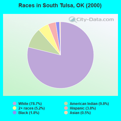
Races in South Tulsa detailed stats: ancestries, foreign born residents, place of birth
 Recent articles from our blog. Our writers, many of them Ph.D. graduates or candidates, create easy-to-read articles on a wide variety of topics.

Current Local Time: CST time zone
Land area: 94.4 square miles.
Population density: 184 people per square mile (very low).
| South Tulsa CCD: | 1.0% ($734) |
| Oklahoma: | 0.8% ($523) |
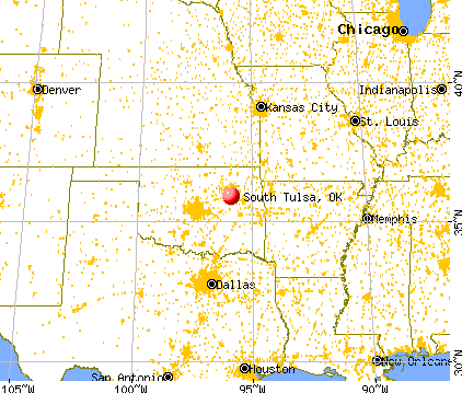
Nearest city with pop. 50,000+: Broken Arrow, OK  (11.4 miles , pop. 74,859).
Nearest city with pop. 200,000+: Tulsa, OK (14.4 miles , pop. 393,049).
Nearest city with pop. 1,000,000+: Dallas, TX (221.5 miles , pop. 1,188,580).
Nearest cities:
), ), Latitude: 35.92 N, Longitude: 95.93 W
Area code commonly used in this area: 918

| Here: | 3.3% |
| Oklahoma: | 3.2% |
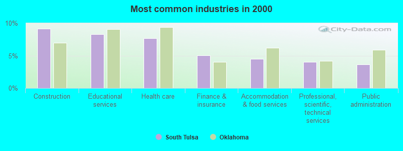
- Construction (9.1%)
- Educational services (8.3%)
- Health care (7.7%)
- Finance & insurance (5.1%)
- Accommodation & food services (4.5%)
- Professional, scientific, technical services (4.0%)
- Public administration (3.7%)
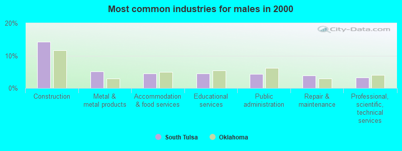
- Construction (14.2%)
- Metal & metal products (5.1%)
- Accommodation & food services (4.5%)
- Educational services (4.4%)
- Public administration (4.3%)
- Repair & maintenance (3.9%)
- Professional, scientific, technical services (3.2%)
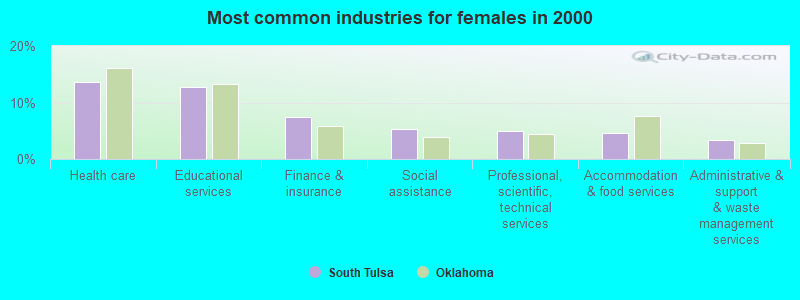
- Health care (13.7%)
- Educational services (12.8%)
- Finance & insurance (7.4%)
- Social assistance (5.2%)
- Professional, scientific, technical services (5.0%)
- Accommodation & food services (4.5%)
- Administrative & support & waste management services (3.4%)
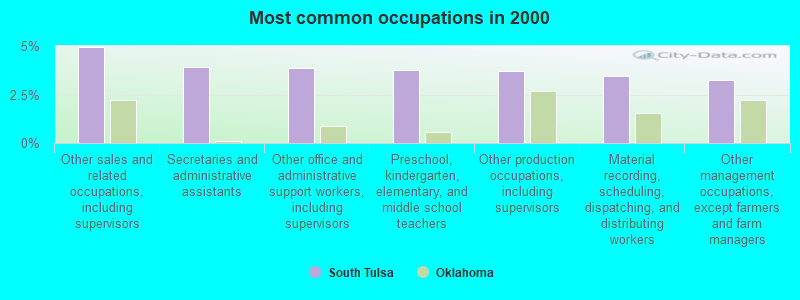
- Other sales and related occupations, including supervisors (4.9%)
- Secretaries and administrative assistants (3.9%)
- Other office and administrative support workers, including supervisors (3.8%)
- Preschool, kindergarten, elementary, and middle school teachers (3.8%)
- Other production occupations, including supervisors (3.7%)
- Material recording, scheduling, dispatching, and distributing workers (3.5%)
- Other management occupations, except farmers and farm managers (3.2%)
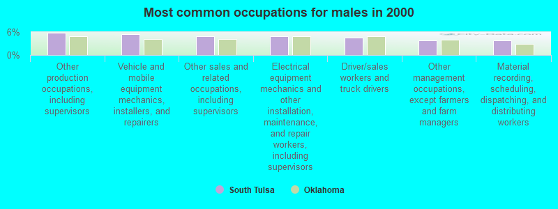
- Other production occupations, including supervisors (5.9%)
- Vehicle and mobile equipment mechanics, installers, and repairers (5.5%)
- Other sales and related occupations, including supervisors (4.9%)
- Electrical equipment mechanics and other installation, maintenance, and repair workers, including supervisors (4.8%)
- Driver/sales workers and truck drivers (4.6%)
- Other management occupations, except farmers and farm managers (3.8%)
- Material recording, scheduling, dispatching, and distributing workers (3.8%)

- Secretaries and administrative assistants (8.3%)
- Preschool, kindergarten, elementary, and middle school teachers (6.7%)
- Other office and administrative support workers, including supervisors (6.6%)
- Information and record clerks, except customer service representatives (5.4%)
- Other sales and related occupations, including supervisors (5.0%)
- Registered nurses (4.8%)
- Child care workers (3.9%)
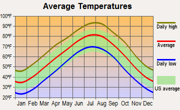
Average climate in South Tulsa, Oklahoma
Based on data reported by over 4,000 weather stations


(lower is better)
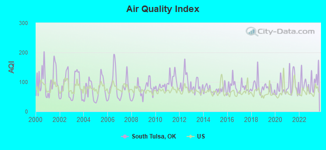
Air Quality Index (AQI) level in 2023 was 109. This is significantly worse than average.
| City: | 109 |
| U.S.: | 73 |
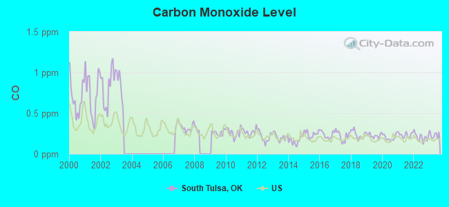
Carbon Monoxide (CO) [ppm] level in 2023 was 0.231. This is about average. Closest monitor was 16.1 miles away from the city center.
| City: | 0.231 |
| U.S.: | 0.251 |
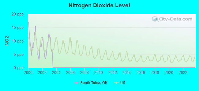
Nitrogen Dioxide (NO2) [ppb] level in 2002 was 7.79. This is significantly worse than average. Closest monitor was 4.7 miles away from the city center.
| City: | 7.79 |
| U.S.: | 5.11 |
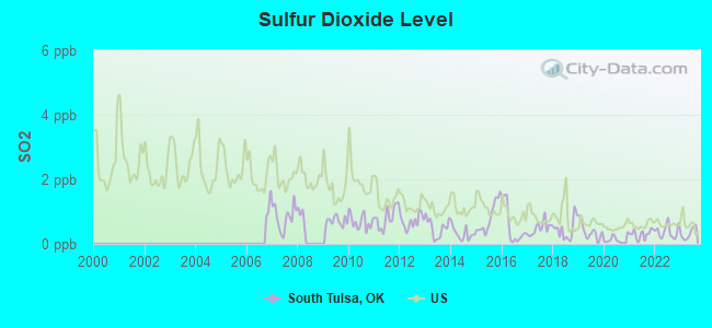
Sulfur Dioxide (SO2) [ppb] level in 2023 was 0.320. This is significantly better than average. Closest monitor was 14.2 miles away from the city center.
| City: | 0.320 |
| U.S.: | 1.515 |
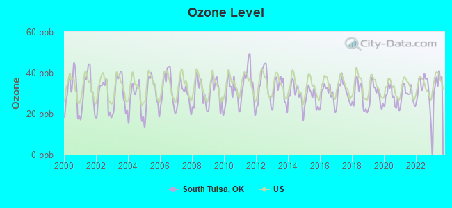
Ozone [ppb] level in 2023 was 35.5. This is about average. Closest monitor was 4.7 miles away from the city center.
| City: | 35.5 |
| U.S.: | 33.3 |
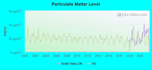
Particulate Matter (PM10) [µg/m3] level in 2023 was 30.2. This is significantly worse than average. Closest monitor was 4.8 miles away from the city center.
| City: | 30.2 |
| U.S.: | 19.2 |
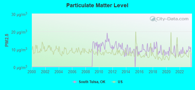
Particulate Matter (PM2.5) [µg/m3] level in 2023 was 10.0. This is worse than average. Closest monitor was 4.7 miles away from the city center.
| City: | 10.0 |
| U.S.: | 8.1 |
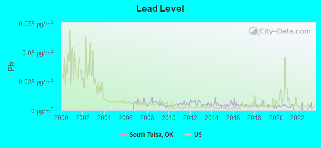
Lead (Pb) [µg/m3] level in 2021 was 0.00329. This is significantly better than average. Closest monitor was 12.8 miles away from the city center.
| City: | 0.00329 |
| U.S.: | 0.00931 |
Tornado activity:
South Tulsa-area historical tornado activity is slightly above Oklahoma state average. It is 183% greater than the overall U.S. average.
On 5/5/1960, a category F5 (max. wind speeds 261-318 mph) tornado 11.7 miles away from the South Tulsa place center killed 5 people and injured 81 people and caused between $500,000 and $5,000,000 in damages.
On 4/24/1993, a category F4 (max. wind speeds 207-260 mph) tornado 16.7 miles away from the place center killed 7 people and injured 100 people and caused between $5,000,000 and $50,000,000 in damages.
Earthquake activity:
South Tulsa-area historical earthquake activity is significantly above Oklahoma state average. It is 794% greater than the overall U.S. average.On 9/3/2016 at 12:02:44, a magnitude 5.8 (5.8 MW, Depth: 3.5 mi, Class: Moderate, Intensity: VI - VII) earthquake occurred 65.7 miles away from the city center
On 11/6/2011 at 03:53:10, a magnitude 5.7 (5.7 MW, Depth: 3.2 mi) earthquake occurred 54.1 miles away from South Tulsa center
On 11/7/2016 at 01:44:24, a magnitude 5.0 (5.0 MW, Depth: 2.8 mi) earthquake occurred 49.0 miles away from the city center
On 11/5/2011 at 07:12:45, a magnitude 4.8 (4.8 MW, Depth: 1.9 mi, Class: Light, Intensity: IV - V) earthquake occurred 53.4 miles away from South Tulsa center
On 11/8/2011 at 02:46:57, a magnitude 4.8 (4.8 MW, Depth: 3.1 mi) earthquake occurred 55.2 miles away from the city center
On 2/13/2016 at 17:07:06, a magnitude 5.1 (5.1 MW, Depth: 5.2 mi) earthquake occurred 159.9 miles away from the city center
Magnitude types: moment magnitude (MW)
Natural disasters:
The number of natural disasters in Tulsa County (34) is a lot greater than the US average (15).Major Disasters (Presidential) Declared: 22
Emergencies Declared: 7
Causes of natural disasters: Storms: 15, Floods: 14, Winter Storms: 9, Tornadoes: 8, Fires: 5, Heavy Rains: 2, Winds: 2, Hurricane: 1, Ice Storm: 1, Snow: 1, Snowstorm: 1, Other: 1 (Note: some incidents may be assigned to more than one category).
Hospitals and medical centers near South Tulsa:
- SOUTHTOWN NURSING AND VENTILATOR CARE (Nursing Home, about 3 miles away; BIXBY, OK)
- GLENNWOOD HEALTHCARE, INC (Nursing Home, about 4 miles away; GLENPOOL, OK)
- CARTER HEALTHCARE, INC (Home Health Center, about 7 miles away; TULSA, OK)
- RIVERSIDE HEALTH CARE CENTER I (Nursing Home, about 8 miles away; JENKS, OK)
- GRACE LIVING CENTER-JENKS (Nursing Home, about 8 miles away; JENKS, OK)
- SAINT FRANCIS HOSPITAL SOUTH Acute Care Hospitals (about 9 miles away; TULSA, OK)
- UNIVERSITY VILLAGE RETIREMENT COMMUNITY (Nursing Home, about 9 miles away; TULSA, OK)
Colleges/universities with over 2000 students nearest to South Tulsa:
- Oral Roberts University (about 9 miles; Tulsa, OK; Full-time enrollment: 3,216)
- Tulsa Community College (about 13 miles; Tulsa, OK; FT enrollment: 12,480)
- University of Tulsa (about 16 miles; Tulsa, OK; FT enrollment: 3,702)
- Oklahoma State University Institute of Technology (about 21 miles; Okmulgee, OK; FT enrollment: 3,243)
- Rogers State University (about 33 miles; Claremore, OK; FT enrollment: 3,482)
- Northeastern State University (about 54 miles; Tahlequah, OK; FT enrollment: 6,895)
- Oklahoma State University-Main Campus (about 66 miles; Stillwater, OK; FT enrollment: 21,700)
Points of interest:
Notable locations in South Tulsa: Liberty Area Fire Protection (A), Bixby Fire Department Station 1 (B), Glenpool Fire Department (C). Display/hide their locations on the map
Shopping Center: Spartan Family Shopping Center (1). Display/hide its location on the map
Churches in South Tulsa include: Leonard Christian Fellowship Church (A), Glenpool Christian Church (B), Faith Free Will Baptist Church (C), Elwood Missionary Church (D), Calvary Baptist Church (E), Saint Clements Catholic Church (F), Midwest Agape Chapel (G), Jehovahs Witnesses (H), First United Methodist Church (I). Display/hide their locations on the map
Cemeteries: Bixby Cemetery (1), Snake Creek Cemetery (2), Sanger Cemetery (3), Duck Creek Cemetery (4), Twin Mounds Cemetery (5). Display/hide their locations on the map
Reservoir: Oknoname 143011 Reservoir (A). Display/hide its location on the map
Creeks: Snake Creek (A), Duck Creek (B). Display/hide their locations on the map
| This place: | 2.8 people |
| Oklahoma: | 2.5 people |
| This place: | 78.4% |
| Whole state: | 66.8% |
| This place: | 5.5% |
| Whole state: | 5.9% |
Likely homosexual households (counted as self-reported same-sex unmarried-partner households)
- Lesbian couples: 0.4% of all households
- Gay men: 0.2% of all households
| This place: | 6.4% |
| Whole state: | 14.7% |
| This place: | 2.4% |
| Whole state: | 6.1% |
155 people in nursing homes in 2000
10 people in agriculture workers' dormitories on farms in 2000
For population 15 years and over in South Tulsa:
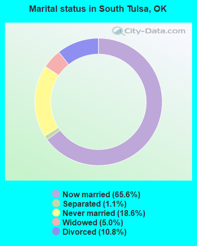
- Never married: 18.6%
- Now married: 65.6%
- Separated: 1.1%
- Widowed: 5.0%
- Divorced: 10.8%
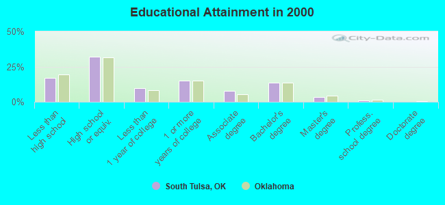
For population 25 years and over in South Tulsa:
- High school or higher: 83.1%
- Bachelor's degree or higher: 18.3%
- Graduate or professional degree: 4.7%
- Unemployed: 3.6%
- Mean travel time to work (commute): 24.6 minutes
| Here: | 10.0 |
| Oklahoma average: | 11.7 |
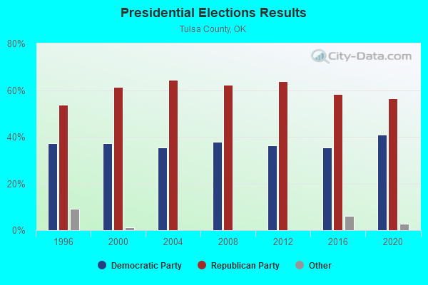
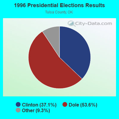
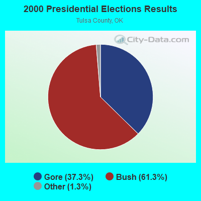

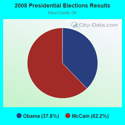
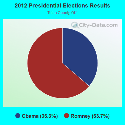
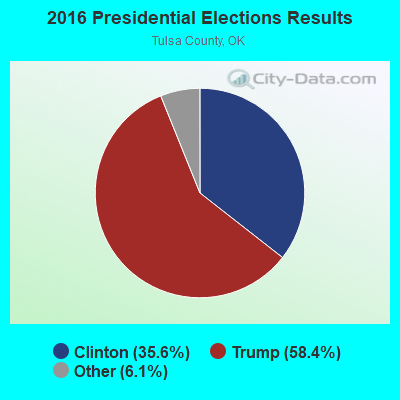
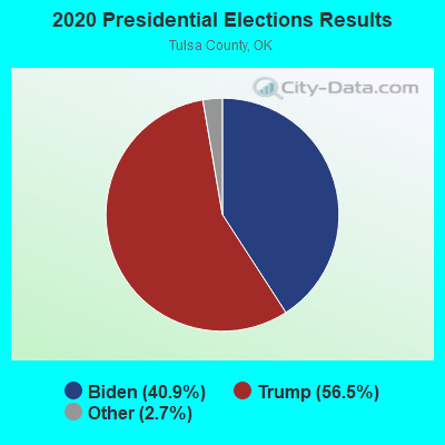
Graphs represent county-level data. Detailed 2008 Election Results
Religion statistics for South Tulsa, OK (based on Tulsa County data)
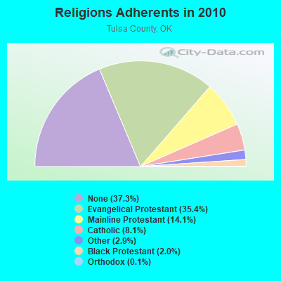
| Religion | Adherents | Congregations |
|---|---|---|
| Evangelical Protestant | 213,615 | 545 |
| Mainline Protestant | 85,250 | 103 |
| Catholic | 49,144 | 23 |
| Other | 17,310 | 49 |
| Black Protestant | 12,226 | 29 |
| Orthodox | 778 | 5 |
| None | 225,080 | - |
Food Environment Statistics:
| Tulsa County: | 1.51 / 10,000 pop. |
| State: | 1.97 / 10,000 pop. |
| This county: | 0.15 / 10,000 pop. |
| Oklahoma: | 0.20 / 10,000 pop. |
| This county: | 0.51 / 10,000 pop. |
| State: | 0.76 / 10,000 pop. |
| Tulsa County: | 2.84 / 10,000 pop. |
| Oklahoma: | 4.35 / 10,000 pop. |
| Tulsa County: | 8.37 / 10,000 pop. |
| Oklahoma: | 6.89 / 10,000 pop. |
| Tulsa County: | 9.4% |
| Oklahoma: | 10.3% |
| This county: | 27.3% |
| Oklahoma: | 29.2% |
6.72% of this county's 2021 resident taxpayers lived in other counties in 2020 ($57,121 average adjusted gross income)
| Here: | 6.72% |
| Oklahoma average: | 8.28% |
0.01% of residents moved from foreign countries ($143 average AGI)
Tulsa County: 0.01% Oklahoma average: 0.04%
Top counties from which taxpayers relocated into this county between 2020 and 2021:
| from Wagoner County, OK | |
| from Rogers County, OK | |
| from Creek County, OK |
6.70% of this county's 2020 resident taxpayers moved to other counties in 2021 ($60,995 average adjusted gross income)
| Here: | 6.70% |
| Oklahoma average: | 7.66% |
0.01% of residents moved to foreign countries ($93 average AGI)
Tulsa County: 0.01% Oklahoma average: 0.03%
Top counties to which taxpayers relocated from this county between 2020 and 2021:
| to Wagoner County, OK | |
| to Rogers County, OK | |
| to Creek County, OK |
Strongest AM radio stations in South Tulsa:
- KFAQ (1170 AM; 50 kW; TULSA, OK; Owner: JOURNAL BROADCAST CORPORATION)
- KRMG (740 AM; 50 kW; TULSA, OK; Owner: CXR HOLDINGS, INC.)
- KAKC (1300 AM; 5 kW; TULSA, OK; Owner: CLEAR CHANNEL BROADCASTING LICENSES, INC.)
- KTBZ (1430 AM; 25 kW; TULSA, OK; Owner: CLEAR CHANNEL BROADCASTING LICENSES, INC.)
- KMUS (1380 AM; 20 kW; MUSKOGEE, OK; Owner: ABC, INC.)
- KYAL (1550 AM; 2 kW; SAPULPA, OK; Owner: KXOJ, INC.)
- KCFO (970 AM; 2 kW; TULSA, OK; Owner: FRIENDSHIP BROADCASTING, L. P.)
- KXTD (1530 AM; daytime; 5 kW; WAGONER, OK; Owner: GAYTAN-GALVAN LIMITED LIABILITY COMP)
- KOMA (1520 AM; 50 kW; OKLAHOMA CITY, OK; Owner: RENDA BROADCASTING CORP. OF NEVADA)
- KGTO (1050 AM; 1 kW; TULSA, OK; Owner: KJMM, INC.)
- KTFX (1340 AM; 1 kW; SAND SPRINGS, OK; Owner: K95.5, INC.)
- KGGF (690 AM; 10 kW; COFFEYVILLE, KS; Owner: KGGF-KUSN, INC.)
- KOKL (1240 AM; 1 kW; OKMULGEE, OK; Owner: REGENCY RADIO, INC.)
Strongest FM radio stations in South Tulsa:
- KJMM (105.3 FM; BIXBY, OK; Owner: KJMM, INC.)
- KHTT (106.9 FM; MUSKOGEE, OK; Owner: RENDA BROADCASTING CORP. OF NEVADA)
- KNYD (90.5 FM; BROKEN ARROW, OK; Owner: CREATIVE EDUCATIONAL MEDIA CORP. INC)
- KXBL (99.5 FM; HENRYETTA, OK; Owner: JOURNAL BROADCAST CORPORATION)
- KJSR (103.3 FM; TULSA, OK; Owner: CXR HOLDINGS, INC.)
- KTSO (94.1 FM; OKMULGEE, OK; Owner: SHAMROCK COMMUNICATIONS, INC)
- KWGS (89.5 FM; TULSA, OK; Owner: THE UNIVERSITY OF TULSA)
- KMYZ-FM (104.5 FM; PRYOR, OK; Owner: SHAMROCK COMMUNICATIONS, INC.)
- KBEZ (92.9 FM; TULSA, OK; Owner: RENDA BROADCASTING CORP. OF NEVADA)
- KMOD-FM (97.5 FM; TULSA, OK; Owner: CLEAR CHANNEL BROADCASTING LICENSES, INC.)
- KRAV-FM (96.5 FM; TULSA, OK; Owner: CXR HOLDINGS, INC.)
- KWEN (95.5 FM; TULSA, OK; Owner: CXR HOLDINGS, INC.)
- KVOO-FM (98.5 FM; TULSA, OK; Owner: JOURNAL BROADCAST CORPORATION)
- KIZS (92.1 FM; BROKEN ARROW, OK; Owner: CLEAR CHANNEL BROADCASTING LICENSES, INC.)
- KXOJ-FM (100.9 FM; SAPULPA, OK; Owner: KXOJ, INC.)
- KQCV-FM (95.1 FM; SHAWNEE, OK; Owner: COMMUNITY BROADCASTING, INC)
- KQLL-FM (106.1 FM; OWASSO, OK; Owner: CLEAR CHANNEL BROADCASTING LICENSES, INC.)
- KRTQ (102.3 FM; SAND SPRINGS, OK; Owner: CXR HOLDINGS, INC.)
- KTBT (101.5 FM; COLLINSVILLE, OK; Owner: CLEAR CHANNEL BROADCASTING LICENSES, INC.)
- KCXR (100.3 FM; TAFT, OK; Owner: KXOJ INC.)
TV broadcast stations around South Tulsa:
- KJRH (Channel 2; TULSA, OK; Owner: SCRIPPS HOWARD BROADCASTING COMPANY)
- KOED-TV (Channel 11; TULSA, OK; Owner: OKLAHOMA EDUCATIONAL TELEVISION AUTHORITY)
- KOTV (Channel 6; TULSA, OK; Owner: GRIFFIN LICENSING, L.L.C.)
- KWHB (Channel 47; TULSA, OK; Owner: LESEA BROADCASTING CORPORATION)
- KTUL (Channel 8; TULSA, OK; Owner: KTUL, LLC)
- KGEB (Channel 53; TULSA, OK; Owner: UNIVERSITY BROADCASTING, INC.)
- KTPX (Channel 44; OKMULGEE, OK; Owner: PAXSON TULSA LICENSE, INC.)
- KTFO (Channel 41; TULSA, OK; Owner: CLEAR CHANNEL BROADCASTING LICENSES, INC.)
- KOKI-TV (Channel 23; TULSA, OK; Owner: CLEAR CHANNEL BROADCASTING LICENSES, INC.)
- KWBT (Channel 19; MUSKOGEE, OK; Owner: TULSA COMMUNICATIONS, L.L.C.)
- K39CW (Channel 39; TULSA, OK; Owner: VENTANA TELEVISION, INC.)
- KTZT-LP (Channel 29; TULSA, OK; Owner: ARACELIS ORTIZ, EXECUTRIX OF THE ESTATE OF CARLOS ORTIZ)
- KOPE-LP (Channel 51; TULSA, OK; Owner: COPELAND BROADCASTING CORPORATION)
- KLOT-LP (Channel 25; TULSA, OK; Owner: EQUITY BROADCASTING CORPORATION)
- K15DA (Channel 15; TULSA, OK; Owner: LOCKE SUPPLY CO.)
- K69GO (Channel 69; TULSA, OK; Owner: THREE ANGELS BROADCASTING NETWORK)
- KDOR (Channel 17; BARTLESVILLE, OK; Owner: TRINITY BROADCASTING NETWORK)
- KRSC-TV (Channel 35; CLAREMORE, OK; Owner: BOARD OF REGENTS OF OKLAHOMA COLLEGES)
- K04NZ (Channel 4; TULSA, OK; Owner: GERALD BROTHERS)
- K33EK (Channel 33; TULSA, OK; Owner: LOCKE SUPPLY CO.)
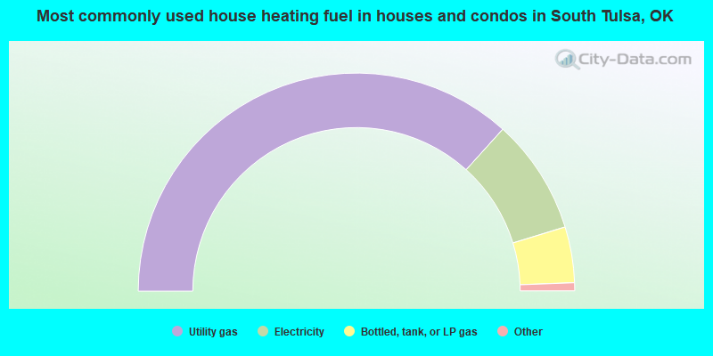
- 73.4%Utility gas
- 17.1%Electricity
- 8.3%Bottled, tank, or LP gas
- 0.6%Wood
- 0.4%Other fuel
- 0.1%Fuel oil, kerosene, etc.
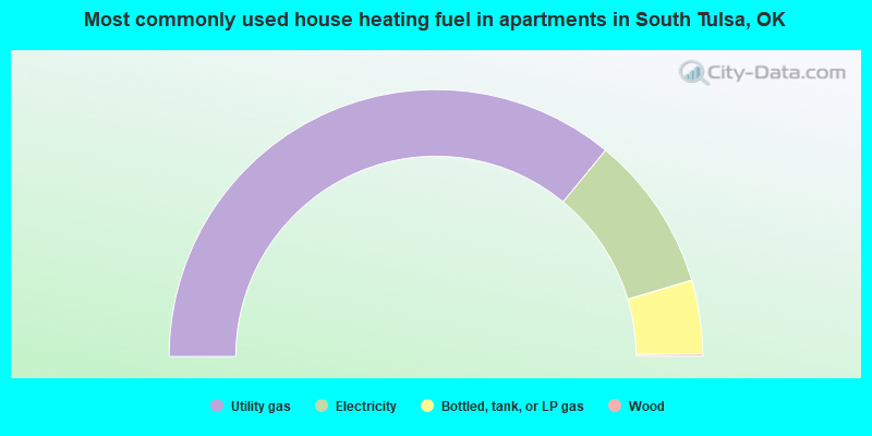
- 72.0%Utility gas
- 18.9%Electricity
- 8.9%Bottled, tank, or LP gas
- 0.3%Wood
South Tulsa compared to Oklahoma state average:
- Unemployed percentage significantly below state average.
- Black race population percentage significantly below state average.
- Hispanic race population percentage significantly below state average.
- Median age below state average.
- Foreign-born population percentage significantly below state average.
- Length of stay since moving in significantly above state average.
- Number of rooms per house significantly below state average.
- House age significantly below state average.
South Tulsa on our top lists:
- #28 on the list of "Top 101 cities with largest percentage of males in industries: motor vehicles, parts and supplies merchant wholesalers (population 5,000+)"
- #31 on the list of "Top 101 cities with largest percentage of females in occupations: extraction workers (population 5,000+)"
- #52 on the list of "Top 101 cities with largest percentage of females in industries: petroleum and coal products (population 5,000+)"
- #53 on the list of "Top 101 cities with largest percentage of females in industries: broadcasting and telecommunications (population 5,000+)"
- #54 on the list of "Top 101 cities with largest percentage of males in industries: air transportation (population 5,000+)"
- #74 on the list of "Top 101 cities with largest percentage of females in occupations: child care workers (population 5,000+)"
- #74 on the list of "Top 101 cities with largest percentage of males in industries: sewing, needlework, and piece goods stores (population 5,000+)"
- #84 on the list of "Top 101 cities with largest percentage of males in industries: machinery, equipment, and supplies merchant wholesalers (population 5,000+)"
- #94 on the list of "Top 101 cities with largest percentage of males in industries: hardware, plumbing and heating equipment, and supplies merchant wholesalers (population 5,000+)"
- #94 on the list of "Top 101 cities with largest percentage of females in industries: sporting goods, camera, and hobby and toy stores (population 5,000+)"
- #98 on the list of "Top 101 cities with largest percentage of females in industries: metals and minerals, except petroleum, merchant wholesalers (population 5,000+)"
- #6 on the list of "Top 101 counties with the highest lead air pollution readings in 2012 (µg/m3)"
- #13 on the list of "Top 101 counties with the lowest percentage of residents relocating from foreign countries between 2010 and 2011 (pop. 50,000+)"
- #20 on the list of "Top 101 counties with the most Evangelical Protestant adherents"
- #22 on the list of "Top 101 counties with the most Evangelical Protestant congregations"
- #24 on the list of "Top 101 counties with the lowest lead air pollution readings in 2012 (µg/m3)"