South Coastside, California
Submit your own pictures of this place and show them to the world
- OSM Map
- General Map
- Google Map
- MSN Map

| Males: 14,891 | |
| Females: 13,673 |
| Median resident age: | 38.7 years |
| California median age: | 33.3 years |
Zip code: 94019
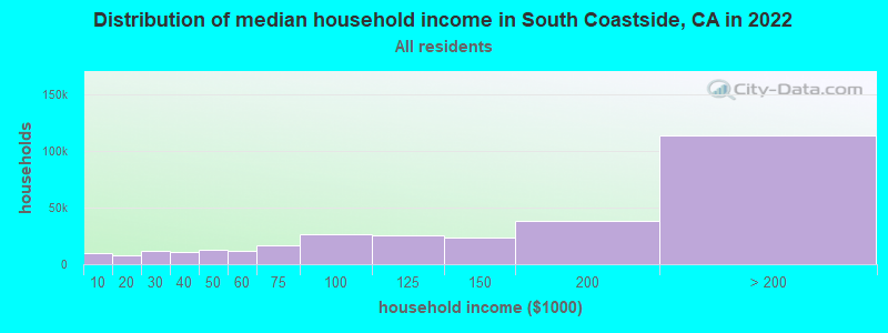
| South Coastside: | $171,779 |
| CA: | $91,551 |
Estimated per capita income in 2022: $85,311 (it was $38,380 in 2000)
South Coastside CCD income, earnings, and wages data
Estimated median house or condo value in 2022: over $1,000,000 (it was $484,300 in 2000)
| South Coastside: | over $1,000,000 |
| CA: | $715,900 |
Mean prices in 2022: all housing units: over $1,000,000; detached houses: over $1,000,000; townhouses or other attached units: over $1,000,000; in 2-unit structures: over $1,000,000; in 3-to-4-unit structures: $987,031; in 5-or-more-unit structures: $930,149; mobile homes: $246,733; occupied boats, rvs, vans, etc.: $489,015
South Coastside, CA residents, houses, and apartments details
Detailed information about poverty and poor residents in South Coastside, CA
Compare current foreclosures near South Coastside, CA:
| Photo | Address | Area | Beds / Baths | Price | Details |
|---|---|---|---|---|---|

|
#1
Troon Way
Half Moon Bay, CA 94019
|
1,540 sq. feet
|
2 baths 3 beds |
show details | |

|
#2
Edgewood Ln
Menlo Park, CA 94025
|
1,750 sq. feet
|
3 baths 3 beds |
show details | |

|
#3
Barmetta Way
Atherton, CA 94027
|
1,780 sq. feet
|
2 baths 3 beds |
show details | |

|
#4
Oak Ct
Menlo Park, CA 94025
|
2,320 sq. feet
|
3 baths 4 beds |
show details | |

|
#5
Sevier Ave
Menlo Park, CA 94025
|
1,030 sq. feet
|
1 baths 3 beds |
show details | |

|
#6
Saratoga Ave
Palo Alto, CA 94303
|
750 sq. feet
|
1 baths 3 beds |
show details | |

|
#7
Cedar St
Redwood City, CA 94063
|
1,390 sq. feet
|
2 baths 3 beds |
show details | |

|
#8
Ralmar Ave
Palo Alto, CA 94303
|
820 sq. feet
|
1 baths 2 beds |
show details | |

|
#9
Ralmar Ave
Palo Alto, CA 94303
|
1,020 sq. feet
|
1 baths 3 beds |
show details | |

|
#10
Ottawa St
San Mateo, CA 94401
|
1,050 sq. feet
|
1 baths 2 beds |
show details |
| Photo | Address | Area | Beds / Baths | Price | Details |
|---|---|---|---|---|---|

|
#11
Okeefe Ln
Los Altos, CA 94022
|
5,358 sq. feet
|
4 baths 5 beds |
show details | |

|
#12
Big Bend Dr
Pacifica, CA 94044
|
2,350 sq. feet
|
3 baths 5 beds |
show details | |

|
#13
Palm Ave Apt 107
Millbrae, CA 94030
|
1,537 sq. feet
|
2 baths 2 beds |
show details | |

|
#14
Lyon Ave
Belmont, CA 94002
|
1,880 sq. feet
|
2 baths 5 beds |
show details | |

|
#15
Chestnut St
San Carlos, CA 94070
|
1,390 sq. feet
|
2 baths 3 beds |
show details | |

|
#16
Hemlock Ave
Millbrae, CA 94030
|
1,080 sq. feet
|
2 baths 2 beds |
show details | |

|
#17
Banyan Way
Pacifica, CA 94044
|
1,220 sq. feet
|
1 baths 3 beds |
show details | |

|
#18
Pullman Rd
Burlingame, CA 94010
|
4,760 sq. feet
|
4 baths 4 beds |
show details | |

|
#19
Hurlingame Ave
Redwood City, CA 94063
|
1,397 sq. feet
|
2 baths 4 beds |
show details | |

|
#20
Fordham St
Palo Alto, CA 94303
|
970 sq. feet
|
1 baths 3 beds |
show details |
| Photo | Address | Area | Beds / Baths | Price | Details |
|---|---|---|---|---|---|

|
#21
Church Ave
San Mateo, CA 94401
|
1,370 sq. feet
|
2 baths 3 beds |
show details | |

|
#22
Peary Ln
San Mateo, CA 94404
|
1,340 sq. feet
|
2 baths 3 beds |
show details | |

|
#23
Yarnall Pl
Redwood City, CA 94063
|
1,120 sq. feet
|
1 baths 3 beds |
show details | |

|
#24
E 3rd Ave
San Mateo, CA 94401
|
1,150 sq. feet
|
1 baths 2 beds |
show details | |

|
#25
W 3rd Ave Apt 302
San Mateo, CA 94402
|
2,300 sq. feet
|
2 baths 2 beds |
show details | |

|
#26
Hoover St
Redwood City, CA 94063
|
1,120 sq. feet
|
1 baths 3 beds |
show details | |

|
#27
Palm Ave
San Mateo, CA 94401
|
2,500 sq. feet
|
2 baths 3 beds |
show details | |

|
#28
Carmelita Ave
Burlingame, CA 94010
|
3,320 sq. feet
|
3 baths 4 beds |
show details | |

|
#29
Del Rosa Way
San Mateo, CA 94403
|
1,080 sq. feet
|
1 baths 3 beds |
show details | |

|
#30
Pelican Ln
Redwood City, CA 94065
|
1,228 sq. feet
|
1 baths 2 beds |
show details |
| Photo | Address | Area | Beds / Baths | Price | Details |
|---|---|---|---|---|---|

|
#31
S Humboldt St
San Mateo, CA 94401
|
1,290 sq. feet
|
2 baths 3 beds |
show details | |

|
#32
Moody Rd
Los Altos, CA 94022
|
1,182 sq. feet
|
2 baths 1 beds |
show details | |

|
#33
Saint Martin Dr
Redwood City, CA 94065
|
1,850 sq. feet
|
2 baths 3 beds |
show details | |

|
#34
N Eldorado St
San Mateo, CA 94401
|
3,570 sq. feet
|
3 baths 5 beds |
show details | |

|
#35
Lindbergh St
San Mateo, CA 94401
|
1,310 sq. feet
|
1 baths 2 beds |
show details | |

|
#36
Santa Rita Ave
Palo Alto, CA 94301
|
1,085 sq. feet
|
1 baths 2 beds |
show details | |

|
#37
Robert Pl
Millbrae, CA 94030
|
1,290 sq. feet
|
1 baths 3 beds |
show details | |

|
#38
9th Ave
San Mateo, CA 94402
|
1,830 sq. feet
|
2 baths 3 beds |
show details | |

|
#39
Alameda De Las Pulgas
Redwood City, CA 94061
|
1,250 sq. feet
|
2 baths 3 beds |
show details | |

|
#40
Sueno Camino
La Honda, CA 94020
|
390 sq. feet
|
1 baths 1 beds |
show details |
| Photo | Address | Area | Beds / Baths | Price | Details |
|---|---|---|---|---|---|

|
#41
W El Camino Real
Mountain View, CA 94040
|
1,612 sq. feet
|
2 baths 5 beds |
show details | |

|
#42
Ebken St
Pacifica, CA 94044
|
1,540 sq. feet
|
2 baths 3 beds |
show details | |

|
#43
Hempstead Pl
Redwood City, CA 94061
|
1,020 sq. feet
|
1 baths 3 beds |
show details | |

|
#44
Mariposa Ave
Mountain View, CA 94041
|
2,403 sq. feet
|
3 baths 4 beds |
show details | |

|
#45
Windsor Way
Redwood City, CA 94061
|
980 sq. feet
|
1 baths 3 beds |
show details | |

|
#46
Chestnut Ave
San Bruno, CA 94066
|
1,360 sq. feet
|
1 baths 3 beds |
show details | |

|
#47
Melendy Dr
San Carlos, CA 94070
|
2,180 sq. feet
|
2 baths 4 beds |
show details | |

|
#48
California St Apt 45
Mountain View, CA 94040
|
668 sq. feet
|
1 baths 1 beds |
show details | |

|
#49
Brittan Ave # 4
San Carlos, CA 94070
|
1,040 sq. feet
|
2 baths 2 beds |
show details | |

|
Check over 1 million property listings on Foreclosure.com!
|
browse all offers | |||

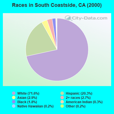
- 20,78771.6%White alone
- 5,88520.3%Hispanic
- 8342.9%Asian alone
- 7692.7%Two or more races
- 5301.8%Black alone
- 890.3%American Indian alone
- 620.2%Native Hawaiian and Other
Pacific Islander alone - 560.2%Other race alone
 Recent articles from our blog. Our writers, many of them Ph.D. graduates or candidates, create easy-to-read articles on a wide variety of topics.
Current Local Time: PST time zone
Land area: 273.2 square miles.
Population density: 105 people per square mile (very low).

| South Coastside CCD: | 0.7% ($3,317) |
| California: | 0.8% ($1,564) |
Nearest city with pop. 50,000+: Redwood City, CA  (10.4 miles , pop. 75,402).
Nearest city with pop. 200,000+: Fremont, CA (24.5 miles , pop. 203,413).
Nearest city with pop. 1,000,000+: Los Angeles, CA (320.6 miles , pop. 3,694,820).
Nearest cities:
), ), Latitude: 37.39 N, Longitude: 122.38 W
Area code commonly used in this area: 650

| Here: | 3.2% |
| California: | 5.1% |
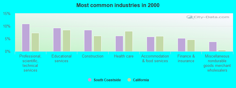
- Professional, scientific, technical services (10.9%)
- Educational services (9.3%)
- Construction (8.4%)
- Health care (6.2%)
- Accommodation & food services (5.9%)
- Finance & insurance (5.2%)
- Miscellaneous nondurable goods merchant wholesalers (3.8%)
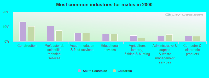
- Construction (13.5%)
- Professional, scientific, technical services (10.4%)
- Accommodation & food services (5.8%)
- Educational services (5.0%)
- Agriculture, forestry, fishing & hunting (4.1%)
- Administrative & support & waste management services (4.0%)
- Computer & electronic products (3.8%)
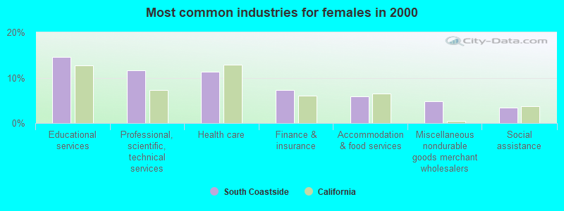
- Educational services (14.6%)
- Professional, scientific, technical services (11.6%)
- Health care (11.3%)
- Finance & insurance (7.2%)
- Accommodation & food services (5.9%)
- Miscellaneous nondurable goods merchant wholesalers (4.7%)
- Social assistance (3.4%)
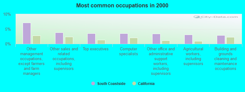
- Other management occupations, except farmers and farm managers (7.1%)
- Other sales and related occupations, including supervisors (3.9%)
- Top executives (3.5%)
- Computer specialists (3.5%)
- Other office and administrative support workers, including supervisors (3.4%)
- Agricultural workers, including supervisors (3.1%)
- Building and grounds cleaning and maintenance occupations (2.9%)
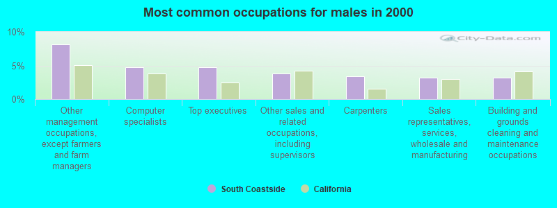
- Other management occupations, except farmers and farm managers (8.1%)
- Computer specialists (4.8%)
- Top executives (4.7%)
- Other sales and related occupations, including supervisors (3.9%)
- Carpenters (3.4%)
- Sales representatives, services, wholesale and manufacturing (3.2%)
- Building and grounds cleaning and maintenance occupations (3.2%)
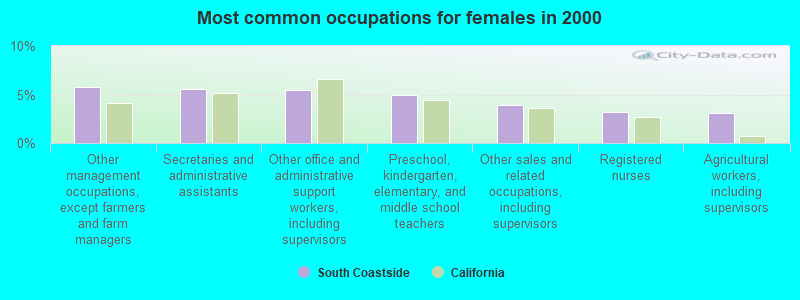
- Other management occupations, except farmers and farm managers (5.8%)
- Secretaries and administrative assistants (5.5%)
- Other office and administrative support workers, including supervisors (5.5%)
- Preschool, kindergarten, elementary, and middle school teachers (5.0%)
- Other sales and related occupations, including supervisors (3.9%)
- Registered nurses (3.2%)
- Agricultural workers, including supervisors (3.1%)
Average climate in South Coastside, California
Based on data reported by over 4,000 weather stations


(lower is better)
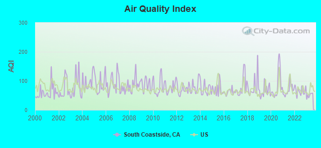
Air Quality Index (AQI) level in 2023 was 50.6. This is significantly better than average.
| City: | 50.6 |
| U.S.: | 72.6 |
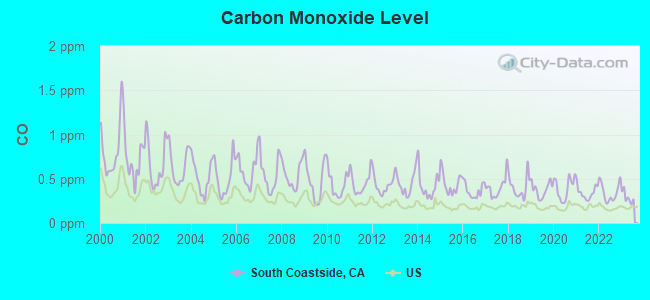
Carbon Monoxide (CO) [ppm] level in 2023 was 0.290. This is about average. Closest monitor was 9.8 miles away from the city center.
| City: | 0.290 |
| U.S.: | 0.251 |
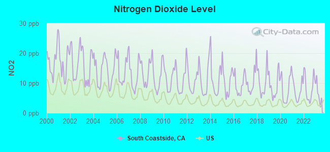
Nitrogen Dioxide (NO2) [ppb] level in 2023 was 6.57. This is worse than average. Closest monitor was 9.8 miles away from the city center.
| City: | 6.57 |
| U.S.: | 5.11 |
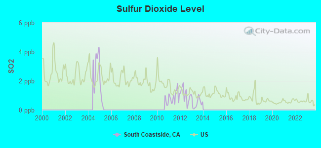
Sulfur Dioxide (SO2) [ppb] level in 2013 was 0.480. This is significantly better than average. Closest monitor was 18.0 miles away from the city center.
| City: | 0.480 |
| U.S.: | 1.515 |
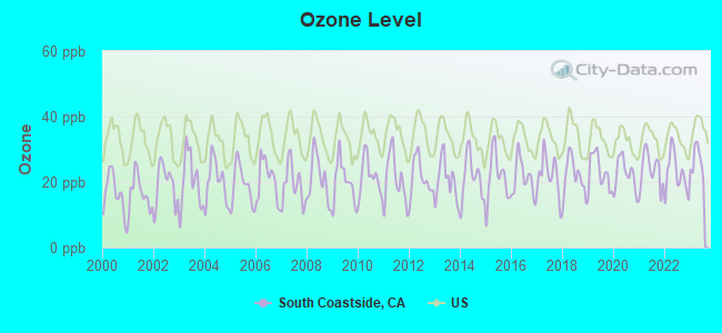
Ozone [ppb] level in 2023 was 26.3. This is better than average. Closest monitor was 9.8 miles away from the city center.
| City: | 26.3 |
| U.S.: | 33.3 |
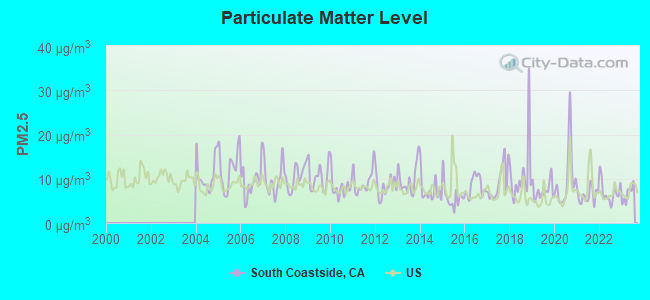
Particulate Matter (PM2.5) [µg/m3] level in 2023 was 6.54. This is better than average. Closest monitor was 11.9 miles away from the city center.
| City: | 6.54 |
| U.S.: | 8.11 |
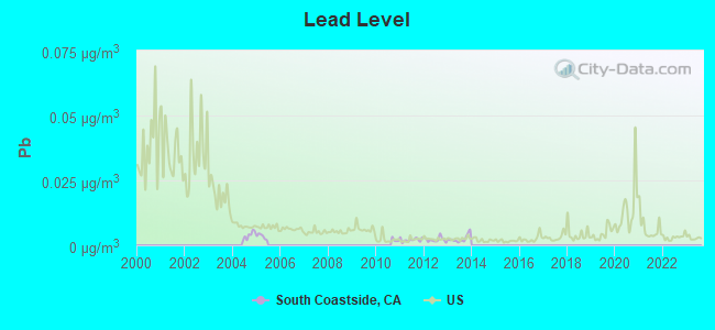
Lead (Pb) [µg/m3] level in 2013 was 0.00251. This is significantly better than average. Closest monitor was 11.9 miles away from the city center.
| City: | 0.00251 |
| U.S.: | 0.00931 |
Earthquake activity:
South Coastside-area historical earthquake activity is significantly above California state average. It is 7266% greater than the overall U.S. average.On 4/18/1906 at 13:12:21, a magnitude 7.9 (7.9 UK, Class: Major, Intensity: VIII - XII) earthquake occurred 54.1 miles away from South Coastside center, causing $524,000,000 total damage
On 10/18/1989 at 00:04:15, a magnitude 7.1 (6.5 MB, 7.1 MS, 6.9 MW, 7.0 ML) earthquake occurred 38.9 miles away from South Coastside center, causing 62 deaths (62 shaking deaths) and 3757 injuries, causing $1,305,032,704 total damage
On 11/4/1927 at 13:51:53, a magnitude 7.5 (7.5 UK) earthquake occurred 187.0 miles away from the city center
On 7/21/1952 at 11:52:14, a magnitude 7.7 (7.7 UK) earthquake occurred 250.9 miles away from the city center, causing $50,000,000 total damage
On 1/31/1922 at 13:17:28, a magnitude 7.6 (7.6 UK) earthquake occurred 285.3 miles away from the city center
On 4/25/1992 at 18:06:04, a magnitude 7.2 (6.3 MB, 7.1 MS, 7.2 MW, 7.1 MW, Depth: 9.4 mi) earthquake occurred 224.0 miles away from the city center, causing $75,000,000 total damage
Magnitude types: body-wave magnitude (MB), local magnitude (ML), surface-wave magnitude (MS), moment magnitude (MW)
Natural disasters:
The number of natural disasters in San Mateo County (18) is near the US average (15).Major Disasters (Presidential) Declared: 11
Emergencies Declared: 2
Causes of natural disasters: Floods: 11, Storms: 6, Mudslides: 5, Winter Storms: 5, Landslides: 4, Fires: 2, Drought: 1, Earthquake: 1, Freeze: 1, Hurricane: 1, Tornado: 1, Other: 1 (Note: some incidents may be assigned to more than one category).
Hospitals and medical centers near South Coastside:
- HOME CARE BY THE SEA, INC. (Home Health Center, about 6 miles away; HALF MOON BAY, CA)
- CORDILLERAS MENTAL HEALTH CENTER (Nursing Home, about 8 miles away; REDWOOD CITY, CA)
- CRESTVIEW ICF/DDN HOME (Hospital, about 9 miles away; BELMONT, CA)
- DEVONSHIRE OAKS NURSING CENTER (Nursing Home, about 9 miles away; REDWOOD CITY, CA)
- SEQUOIAS, THE (Nursing Home, about 10 miles away; PORTOLA VALLEY, CA)
- SEQUOIA HOSPITAL Acute Care Hospitals (about 10 miles away; REDWOOD CITY, CA)
- CARLMONT GARDENS NURSING CENTER (Nursing Home, about 10 miles away; BELMONT, CA)
Amtrak stations near South Coastside:
- 15 miles: MILLBRAE (MILLBRAE AVE. & CALIFORNIA DR.) - Bus Station . Services: fully wheelchair accessible, public payphones, free short-term parking, call for taxi service, public transit connection.
- 16 miles: SAN FRANCISCO INT'L AIRPO (SAN BRUNO, SAN FRANCISCO INTERNATIONAL AIRPORT) - Bus Station . Services: fully wheelchair accessible, enclosed waiting area, public restrooms, public payphones, snack bar, paid short-term parking, paid long-term parking, car rental agency, taxi stand, public transit connection.
Colleges/universities with over 2000 students nearest to South Coastside:
- Canada College (about 8 miles; Redwood City, CA; Full-time enrollment: 3,446)
- College of San Mateo (about 11 miles; San Mateo, CA; FT enrollment: 5,398)
- Stanford University (about 12 miles; Stanford, CA; FT enrollment: 14,410)
- Foothill College (about 15 miles; Los Altos Hills, CA; FT enrollment: 9,635)
- Skyline College (about 18 miles; San Bruno, CA; FT enrollment: 5,824)
- De Anza College (about 20 miles; Cupertino, CA; FT enrollment: 16,729)
- Mission College (about 23 miles; Santa Clara, CA; FT enrollment: 5,625)
Points of interest:
Notable locations in South Coastside: Notley Junction (A), Coastways Ranch (B), Burns Ranch (C), Camp Pomponio (D), Globe Wireless Receiving Station (E), Woodhaven Camp (F), Sandy Point Guard Station (G), San Francisco Camp (H), Pulgas Water Temple (I), Pomponio Ranch (J), Point Montara Light Station (K), Pise Lookout (L), Page Mill (M), Oakland Camp (N), Ox Mountain Sanitary Landfill (O), Horseshoe Ranch (P), Six Bridge Trail Picnic Area (Q), Circle Group Camp (R), Ben Ries Camp Ground (S), Tarwater Trail Camp (T). Display/hide their locations on the map
Shopping Center: Strawflower Village Shopping Center (1). Display/hide its location on the map
Church in South Coastside: First Congregational Church of Pescadero (A). Display/hide its location on the map
Cemeteries: Saint Anthony Cemetery (1), Skylawn Memorial Gardens (2), Independent Order of Oddfellows Cemetery (3), Pilarcitos Cemetery (4), Mount Hope Cemetery (5). Display/hide their locations on the map
Lakes and reservoirs: Knuedler Lake (A), Reflection Lake (B), Pearsons Pond (C), Mindego Lake (D), Big Lagoon (E), Little Lagoon (F), Upper Crystal Springs Reservoir (G), Stone Dam Reservoir (H). Display/hide their locations on the map
Streams, rivers, and creeks: Bloomquist Creek (A), Bogess Creek (B), Bradley Creek (C), Carriger Creek (D), Clear Creek (E), Coyote Creek (F), Dry Creek (G), Elliot Creek (H), Evans Creek (I). Display/hide their locations on the map
Parks in South Coastside include: Memorial Park (1), Half Moon Bay State Beach (2), Portola Redwoods State Park (3), San Mateo Coast State Beaches (4), Butano State Park (5), San Francisco State Fish and Game Refuge (6), Bean Hollow State Beach (7), Gray Whale Cove State Beach (8), Pescadero Marsh Natural Preserve (9). Display/hide their locations on the map
Beaches: Tunitas Beach (A), Pomponio Beach (B), Miramar Beach (C), Vallejo Beach (D), Venice Beach (E), Redondo Beach (F), Manhattan Beach (G), San Gregorio Beach (H), Elmar Beach (I). Display/hide their locations on the map
| This place: | 2.8 people |
| California: | 2.9 people |
| This place: | 55.9% |
| Whole state: | 69.4% |
| This place: | 6.2% |
| Whole state: | 5.9% |
Likely homosexual households (counted as self-reported same-sex unmarried-partner households)
- Lesbian couples: 0.8% of all households
- Gay men: 0.5% of all households
| This place: | 6.0% |
| Whole state: | 14.2% |
| This place: | 2.9% |
| Whole state: | 6.3% |
People in group quarters in South Coastside in 2000:
- 860 people in local jails and other confinement facilities (including police lockups)
- 422 people in agriculture workers' dormitories on farms
- 111 people in hospitals/wards and hospices for chronically ill
- 111 people in other hospitals or wards for chronically ill
- 40 people in training schools for juvenile delinquents
- 38 people in unknown juvenile institutions
- 16 people in other noninstitutional group quarters
- 12 people in nursing homes
- 11 people in other nonhousehold living situations
- 3 people in religious group quarters
For population 15 years and over in South Coastside:
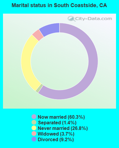
- Never married: 26.8%
- Now married: 60.3%
- Separated: 1.4%
- Widowed: 3.7%
- Divorced: 9.2%
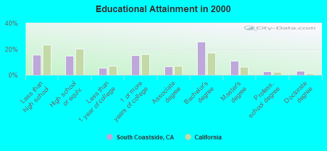
For population 25 years and over in South Coastside:
- High school or higher: 84.4%
- Bachelor's degree or higher: 42.3%
- Graduate or professional degree: 16.6%
- Unemployed: 4.2%
- Mean travel time to work (commute): 29.5 minutes
| Here: | 14.7 |
| California average: | 16.1 |
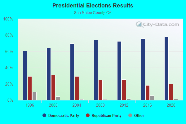
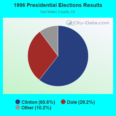
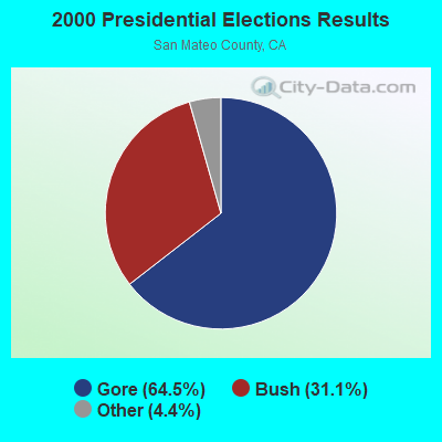
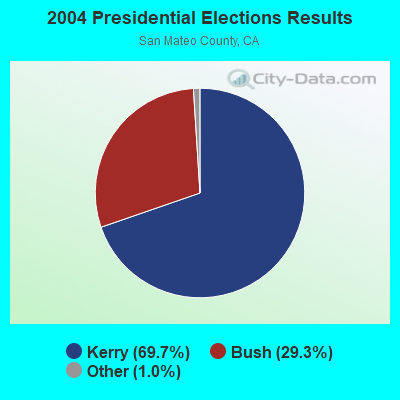

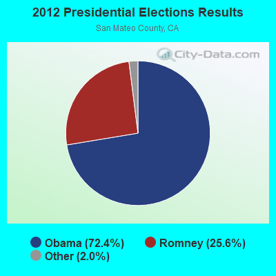
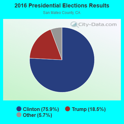
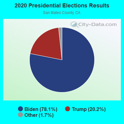
Graphs represent county-level data. Detailed 2008 Election Results
Religion statistics for South Coastside, CA (based on San Mateo County data)
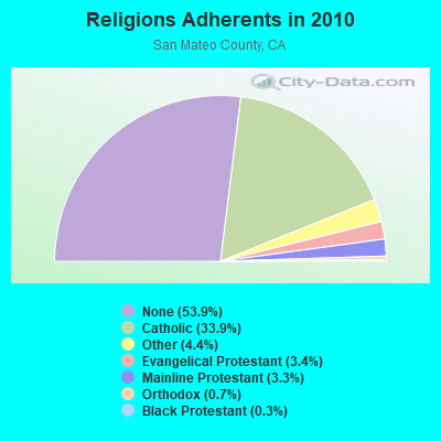
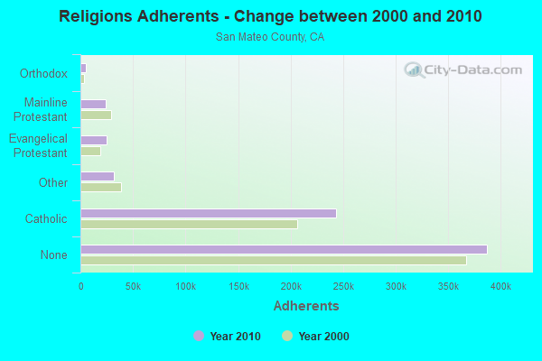
| Religion | Adherents | Congregations |
|---|---|---|
| Catholic | 243,634 | 22 |
| Other | 31,697 | 78 |
| Evangelical Protestant | 24,771 | 166 |
| Mainline Protestant | 23,840 | 74 |
| Orthodox | 5,350 | 5 |
| Black Protestant | 2,046 | 12 |
| None | 387,113 | - |
Food Environment Statistics:
| This county: | 2.44 / 10,000 pop. |
| State: | 2.14 / 10,000 pop. |
| This county: | 0.06 / 10,000 pop. |
| California: | 0.04 / 10,000 pop. |
| This county: | 0.56 / 10,000 pop. |
| California: | 0.62 / 10,000 pop. |
| This county: | 1.62 / 10,000 pop. |
| State: | 1.49 / 10,000 pop. |
| This county: | 10.02 / 10,000 pop. |
| California: | 7.42 / 10,000 pop. |
| This county: | 7.1% |
| California: | 7.3% |
| San Mateo County: | 16.9% |
| California: | 21.3% |
| Here: | 18.0% |
| California: | 17.9% |
6.99% of this county's 2021 resident taxpayers lived in other counties in 2020 ($178,839 average adjusted gross income)
| Here: | 6.99% |
| California average: | 5.19% |
0.01% of residents moved from foreign countries ($58 average AGI)
San Mateo County: 0.01% California average: 0.03%
Top counties from which taxpayers relocated into this county between 2020 and 2021:
| from San Francisco County, CA | |
| from Santa Clara County, CA | |
| from Alameda County, CA |
9.90% of this county's 2020 resident taxpayers moved to other counties in 2021 ($222,747 average adjusted gross income)
| Here: | 9.90% |
| California average: | 6.14% |
0.01% of residents moved to foreign countries ($372 average AGI)
San Mateo County: 0.01% California average: 0.02%
Top counties to which taxpayers relocated from this county between 2020 and 2021:
| to Santa Clara County, CA | |
| to San Francisco County, CA | |
| to Alameda County, CA |
Strongest AM radio stations in South Coastside:
- KNBR (680 AM; 50 kW; SAN FRANCISCO, CA; Owner: KNBR LICO, INC.)
- KYCY (1550 AM; 50 kW; SAN FRANCISCO, CA; Owner: INFINITY BROADCASTING OPERATIONS, INC.)
- KGO (810 AM; 50 kW; SAN FRANCISCO, CA; Owner: KGO-AM RADIO, INC.)
- KTCT (1050 AM; 50 kW; SAN MATEO, CA; Owner: SUSQUEHANNA RADIO CORP.)
- KFAX (1100 AM; 50 kW; SAN FRANCISCO, CA; Owner: GOLDEN GATE BROADCASTING CO, INC.)
- KTRB (860 AM; 50 kW; MODESTO, CA; Owner: PAPPAS RADIO OF CALIFORNIA, A CALIFORNIA LIMITED PARTNERSHIP)
- KLOK (1170 AM; 50 kW; SAN JOSE, CA; Owner: ENTRAVISION HOLDINGS, LLC)
- KIQI (1010 AM; 35 kW; SAN FRANCISCO, CA; Owner: RADIO UNICA OF SAN FRANCISCO LICENSE CORP.)
- KCBS (740 AM; 50 kW; SAN FRANCISCO, CA; Owner: INFINITY BROADCASTING OPERATIONS, INC.)
- KSFB (1220 AM; 5 kW; PALO ALTO, CA; Owner: SCA-PALO ALTO, LLC)
- KNEW (910 AM; 20 kW; OAKLAND, CA; Owner: AMFM RADIO LICENSES, L.L.C.)
- KSFO (560 AM; 5 kW; SAN FRANCISCO, CA; Owner: KGO-AM RADIO, INC.)
- KSJX (1500 AM; 10 kW; SAN JOSE, CA; Owner: MULTICULTURAL RADIO BROADCASTING INC)
Strongest FM radio stations in South Coastside:
- KFJC (89.7 FM; LOS ALTOS, CA; Owner: FOOTHILL-DE ANZA COMM. COLLEGE DIST.)
- KYLD (94.9 FM; SAN FRANCISCO, CA; Owner: AMFM RADIO LICENSES, L.L.C.)
- KFRC-FM (99.7 FM; SAN FRANCISCO, CA; Owner: INFINITY KFRC-FM, INC.)
- KSQL (99.1 FM; SANTA CRUZ, CA; Owner: TMS LICENSE CALIFORNIA, INC)
- KBLX-FM (102.9 FM; BERKELEY, CA; Owner: ICBC BROADCAST HOLDINGS - CA, INC.)
- KZBR (95.7 FM; SAN FRANCISCO, CA; Owner: BONNEVILLE HOLDING COMPANY)
- KMEL (106.1 FM; SAN FRANCISCO, CA; Owner: AMFM RADIO LICENSES, L.L.C.)
- KKUP (91.5 FM; CUPERTINO, CA; Owner: ASSURANCE SCIENCES FOUNDATION)
- KBRG (100.3 FM; SAN JOSE, CA; Owner: ENTRAVISION HOLDINGS, LLC)
- KKSF-FM1 (103.7 FM; PLEASANTON, ETC., CA; Owner: AMFM RADIO LICENSES, L.L.C.)
- KSAN (107.7 FM; SAN MATEO, CA; Owner: SUSQUEHANNA RADIO CORP.)
- KBAA (94.5 FM; GILROY, CA; Owner: INFINITY RADIO OPERATIONS INC.)
- KQED-FM (88.5 FM; SAN FRANCISCO, CA; Owner: KQED, INC.)
- KOIT-FM (96.5 FM; SAN FRANCISCO, CA; Owner: BONNEVILLE HOLDING COMPANY)
- KITS (105.3 FM; SAN FRANCISCO, CA; Owner: INFINITY BROADCASTING OPERATIONS, INC.)
- KFRC-FM3 (99.7 FM; WALNUT CREEK, CA; Owner: INFINITY KFRC-FM, INC.)
- KZBR-FM1 (95.7 FM; WALNUT CREEK, CA; Owner: BONNEVILLE HOLDING COMPANY)
- KBLX-FM2 (102.9 FM; PLEASANTON, CA; Owner: ICBC BROADCAST HOLDINGS -CA, INC.)
- KSOL-FM3 (98.9 FM; PLEASANTON, CA; Owner: TMS LICENSE CALIFORNIA, INC)
- KTEE (93.7 FM; FELTON, CA; Owner: MAPLETON COMMUNICATIONS, L.L.C.)
TV broadcast stations around South Coastside:
- KQED (Channel 9; SAN FRANCISCO, CA; Owner: KQED, INC.)
- KGO-TV (Channel 7; SAN FRANCISCO, CA; Owner: KGO TELEVISION, INC.)
- KPIX-TV (Channel 5; SAN FRANCISCO, CA; Owner: CBS BROADCASTING INC.)
- KTVU (Channel 2; OAKLAND, CA; Owner: KTVU PARTNERSHIP)
- KRON-TV (Channel 4; SAN FRANCISCO, CA; Owner: YOUNG BROADCASTING OF SAN FRANCISCO, INC.)
- KCSM-TV (Channel 60; SAN MATEO, CA; Owner: SAN MATEO COUNTY COMMUNITY COLLEGE DISTRICT)
- KMTP-TV (Channel 32; SAN FRANCISCO, CA; Owner: MINORITY TELEVISION PROJECT)
- KBHK-TV (Channel 44; SAN FRANCISCO, CA; Owner: VIACOM TELEVISION STATIONS GROUP OF SAN FRANCISCO INC.)
- KBWB (Channel 20; SAN FRANCISCO, CA; Owner: KBWB LICENSE, INC.)
- KFSF (Channel 66; VALLEJO, CA; Owner: TELEFUTURA SAN FRANCISCO LLC)
- KCNS (Channel 38; SAN FRANCISCO, CA; Owner: WRAY, INC.)
- KBIT-CA (Channel 28; SAN FRANCISCO, ETC., CA; Owner: POLAR BROADCASTING, INC.)
- KICU-TV (Channel 36; SAN JOSE, CA; Owner: KTVU PARTNERSHIP)
- KTEH (Channel 54; SAN JOSE, CA; Owner: KTEH FOUNDATION)
- KTSF (Channel 26; SAN FRANCISCO, CA; Owner: LINCOLN BROADCASTING COMPANY, A CALIFORNIA LP)
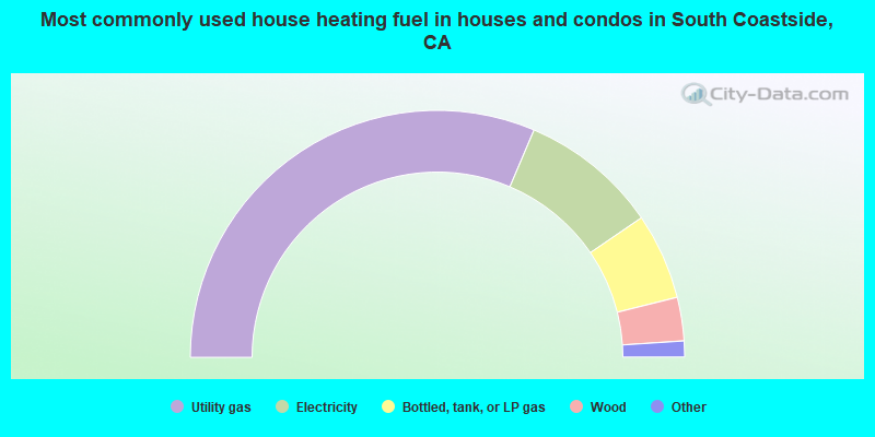
- 62.8%Utility gas
- 18.1%Electricity
- 11.3%Bottled, tank, or LP gas
- 5.7%Wood
- 1.0%Fuel oil, kerosene, etc.
- 0.5%Other fuel
- 0.4%Solar energy
- 0.2%No fuel used
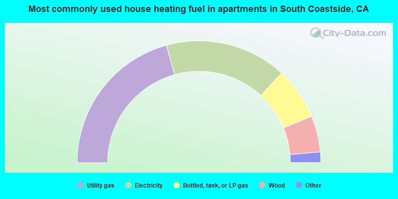
- 41.4%Utility gas
- 32.3%Electricity
- 13.9%Bottled, tank, or LP gas
- 9.6%Wood
- 1.6%No fuel used
- 0.7%Other fuel
- 0.5%Fuel oil, kerosene, etc.
South Coastside compared to California state average:
- Median household income above state average.
- Unemployed percentage significantly below state average.
- Black race population percentage below state average.
- Hispanic race population percentage below state average.
- Median age above state average.
- Foreign-born population percentage significantly below state average.
- Renting percentage significantly below state average.
- Length of stay since moving in significantly above state average.
- Number of rooms per house significantly below state average.
- House age significantly below state average.
- Institutionalized population percentage significantly above state average.
- Percentage of population with a bachelor's degree or higher above state average.
South Coastside on our top lists:
- #1 on the list of "Top 101 cities with largest percentage of females in industries: miscellaneous nondurable goods merchant wholesalers (population 5,000+)"
- #5 on the list of "Top 101 cities with largest percentage of males in industries: miscellaneous nondurable goods merchant wholesalers (population 5,000+)"
- #17 on the list of "Top 101 cities with largest percentage of females in occupations: social scientists and related workers (population 5,000+)"
- #25 on the list of "Top 101 cities with largest percentage of males in industries: air transportation (population 5,000+)"
- #29 on the list of "Top 101 cities with largest percentage of females in occupations: agricultural workers including supervisors (population 5,000+)"
- #33 on the list of "Top 101 cities with largest percentage of females in industries: music stores (population 5,000+)"
- #34 on the list of "Top 101 cities with largest percentage of males in industries: data processing, libraries, and other information services (population 5,000+)"
- #45 on the list of "Top 101 cities with largest percentage of females in occupations: life and physical scientists (population 5,000+)"
- #47 on the list of "Top 101 cities with largest percentage of females in occupations: operations specialties managers except financial managers (population 5,000+)"
- #50 on the list of "Top 101 cities with largest percentage of females in occupations: other health diagnosing and treating practitioners and technical occupations (population 5,000+)"
- #64 on the list of "Top 101 cities with the largest percentage of people in agriculture workers' dormitories on farms (population 1,000+)"
- #83 on the list of "Top 101 cities with largest percentage of females in industries: radio, tv, and computer stores (population 5,000+)"
- #89 on the list of "Top 101 cities with largest percentage of males in occupations: operations specialties managers except financial managers (population 5,000+)"
- #89 on the list of "Top 101 cities with largest percentage of females in industries: air transportation (population 5,000+)"
- #6 on the list of "Top 101 counties with the highest percentage of residents that exercised in the past month"
- #8 on the list of "Top 101 counties with the highest percentage of residents that drank alcohol in the past 30 days"
- #9 on the list of "Top 101 counties with the lowest Ozone (1-hour) air pollution readings in 2012 (ppm)"
- #10 on the list of "Top 101 counties with the highest carbon monoxide air pollution readings in 2012 (ppm)"
- #11 on the list of "Top 101 counties with the lowest average weight of females"
State forum archive:
- California Pages: 2 3 4 5 6 7 8 9 10 11 12 13 14 15 16 17 18 19 20 21 22 23 24 25 26 27 28 29 30 31 32 33 34 35 36 37 38 39 40 41 42 43 44 45 46 47 48 49 50 51 52 53 54 55 56 57 58 59 60 61 62 63 64 65 66 67 68 69 70 71 72 73 74 75 76 77 78 79
- Los Angeles Pages: 2 3 4 5 6 7 8 9 10 11 12 13 14 15 16 17 18 19 20 21 22 23 24 25 26 27 28 29 30 31 32 33 34 35 36 37 38 39 40 41 42 43 44 45 46 47 48 49 50 51 52 53 54 55 56 57 58 59 60 61 62 63 64 65 66 67 68 69 70 71 72 73 74 75 76 77 78 79 80 81 82 83 84 85 86 87 88 89 90 91 92 93 94 95 96 97 98 99 100 101 102 103 104 105 106 107 108 109 110 111 112 113 114 115 116 117 118 119 120 121 122 123
- Monterey County Pages: 2 3
- Orange County Pages: 2 3 4 5 6 7 8 9 10 11 12 13 14 15 16 17 18 19 20 21 22 23 24 25 26 27 28 29 30 31 32 33 34 35 36
- Sacramento Pages: 2 3 4 5 6 7 8 9 10 11 12 13 14 15 16 17 18 19 20 21 22 23 24 25 26 27 28 29 30 31 32
- San Bernardino and Riverside Counties Pages: 2 3 4 5 6 7 8 9 10 11 12 13 14 15 16 17 18 19 20 21 22 23
- San Diego Pages: 2 3 4 5 6 7 8 9 10 11 12 13 14 15 16 17 18 19 20 21 22 23 24 25 26 27 28 29 30 31 32 33 34 35 36 37 38 39 40 41 42 43 44 45 46 47 48 49 50 51 52 53 54 55 56 57 58 59 60 61 62 63 64 65 66 67 68 69 70 71 72 73 74 75 76
- San Francisco - Oakland Pages: 2 3 4 5 6 7 8 9 10 11 12 13 14 15 16 17 18 19 20 21 22 23 24 25 26 27 28 29 30 31 32 33 34 35 36 37 38 39 40 41 42 43 44 45 46 47 48 49 50 51 52 53 54 55 56 57 58 59 60 61 62 63 64 65 66 67 68 69 70 71 72
- San Jose Pages: 2 3 4 5 6 7 8 9 10 11 12 13 14 15 16 17 18 19 20 21 22 23 24
- Ventura County Pages: 2 3 4 5 6 7