Sardis, Alabama
Submit your own pictures of this place and show them to the world
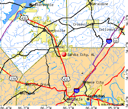
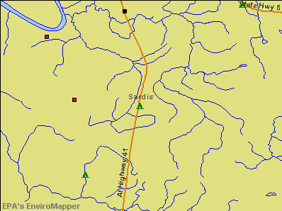
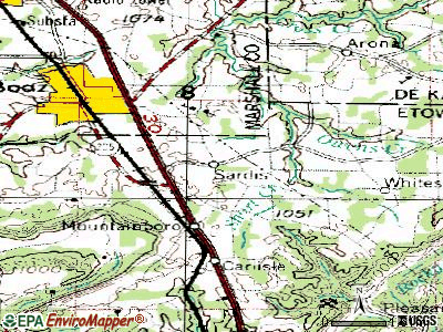
- OSM Map
- General Map
- Google Map
- MSN Map
| Males: 704 | |
| Females: 805 |
| Median resident age: | 40.9 years |
| Alabama median age: | 35.8 years |
Zip code: 36775
| Sardis: | $40,199 |
| AL: | $59,674 |
Estimated per capita income in 2022: $24,496 (it was $14,466 in 2000)
Sardis CCD income, earnings, and wages data
Estimated median house or condo value in 2022: $122,339 (it was $68,100 in 2000)
| Sardis: | $122,339 |
| AL: | $200,900 |
Mean prices in 2022: all housing units: $166,934; detached houses: $199,891; townhouses or other attached units: $50,935; in 2-unit structures: $87,751; in 3-to-4-unit structures: $130,889; mobile homes: $78,420
Detailed information about poverty and poor residents in Sardis, AL
Compare current foreclosures near Sardis, AL:
| Photo | Address | Area | Beds / Baths | Price | Details |
|---|---|---|---|---|---|

|
#1
County Road 30
Sardis, AL 36775
|
1,847 sq. feet
|
- baths - beds |
show details | |

|
#2
County Road 30
Sardis, AL 36775
|
1,025 sq. feet
|
- baths - beds |
show details | |

|
#3
Al Highway 41
Sardis, AL 36775
|
- sq. feet
|
- baths - beds |
show details | |

|
#4
Al Highway 41
Sardis, AL 36775
|
- sq. feet
|
- baths - beds |
show details | |

|
#5
Grindle Ave
Selma, AL 36703
|
2,446 sq. feet
|
2 baths 3 beds |
$239,500
|
show details |

|
#6
Merrifield Dr
Selma, AL 36703
|
1,775 sq. feet
|
2 baths 3 beds |
show details | |

|
#7
Lauderdale St
Selma, AL 36701
|
2,576 sq. feet
|
1 baths 3 beds |
show details | |

|
#8
County Road 74
Selma, AL 36703
|
1,932 sq. feet
|
2 baths 3 beds |
show details | |

|
#9
Alabama Ave # 219
Selma, AL 36701
|
987 sq. feet
|
1 baths 2 beds |
show details | |

|
#10
Carter Ln
Selma, AL 36703
|
2,063 sq. feet
|
3 baths 3 beds |
show details |
| Photo | Address | Area | Beds / Baths | Price | Details |
|---|---|---|---|---|---|

|
#11
County Road 232
Selma, AL 36701
|
1,957 sq. feet
|
2 baths 3 beds |
show details | |

|
#12
W Dallas Ave
Selma, AL 36701
|
1,480 sq. feet
|
1 baths 3 beds |
show details | |

|
#13
Hayden St
Selma, AL 36703
|
1,505 sq. feet
|
1 baths 3 beds |
show details | |

|
#14
County Road 163
Orrville, AL 36767
|
- sq. feet
|
- baths - beds |
show details | |

|
#15
Springdale St
Selma, AL 36701
|
1,209 sq. feet
|
- baths - beds |
show details | |

|
#16
N Broad St
Selma, AL 36701
|
- sq. feet
|
- baths - beds |
show details | |

|
#17
N Broad St Apt 605
Selma, AL 36701
|
- sq. feet
|
- baths - beds |
show details | |

|
#18
Lincoln Dr Apt 112h
Selma, AL 36701
|
- sq. feet
|
- baths - beds |
show details | |

|
#19
Mcdonald Ave
Selma, AL 36701
|
1,360 sq. feet
|
- baths - beds |
show details | |

|
#20
La Dayne Ave
Selma, AL 36701
|
1,566 sq. feet
|
- baths - beds |
show details |
| Photo | Address | Area | Beds / Baths | Price | Details |
|---|---|---|---|---|---|

|
#21
Elm St
Selma, AL 36701
|
1,676 sq. feet
|
- baths - beds |
show details | |

|
#22
Summerfield Rd
Selma, AL 36701
|
- sq. feet
|
- baths - beds |
show details | |

|
#23
Earl Goodwin Pkwy Apt 44
Selma, AL 36703
|
- sq. feet
|
- baths - beds |
show details | |

|
#24
Earl Goodwin Pkwy Apt K5
Selma, AL 36703
|
- sq. feet
|
- baths - beds |
show details | |

|
#25
Cedar Dr
Selma, AL 36701
|
2,569 sq. feet
|
- baths - beds |
show details | |

|
#26
Cedar Dr
Selma, AL 36701
|
- sq. feet
|
- baths - beds |
show details | |

|
#27
College Drive, C
Selma, AL 36701
|
- sq. feet
|
- baths - beds |
show details | |

|
#28
Mangum Ave
Selma, AL 36701
|
1,898 sq. feet
|
- baths - beds |
show details | |

|
#29
Crestwood Dr
Selma, AL 36701
|
2,402 sq. feet
|
- baths - beds |
show details | |

|
#30
Crestwood Dr
Selma, AL 36701
|
2,614 sq. feet
|
- baths - beds |
show details |
| Photo | Address | Area | Beds / Baths | Price | Details |
|---|---|---|---|---|---|

|
#31
Woodrow Ave
Selma, AL 36701
|
1,400 sq. feet
|
- baths - beds |
show details | |

|
#32
River Rd
Selma, AL 36703
|
1,336 sq. feet
|
- baths - beds |
show details | |

|
#33
9th Ave
Selma, AL 36701
|
1,692 sq. feet
|
- baths - beds |
show details | |

|
#34
Lauderdale St
Selma, AL 36701
|
- sq. feet
|
- baths - beds |
show details | |

|
#35
La Foret Dr
Selma, AL 36701
|
1,777 sq. feet
|
- baths - beds |
show details | |

|
#36
Rangedale, Apt B
Selma, AL 36701
|
- sq. feet
|
- baths - beds |
show details | |

|
#37
Medical Center Pkwy Apt 303
Selma, AL 36701
|
- sq. feet
|
- baths - beds |
show details | |

|
#38
Memorial Ave
Selma, AL 36703
|
996 sq. feet
|
- baths - beds |
show details | |

|
#39
Marie Foster St Apt 506
Selma, AL 36703
|
- sq. feet
|
- baths - beds |
show details | |

|
#40
Marie Foster St
Selma, AL 36703
|
- sq. feet
|
- baths - beds |
show details |
| Photo | Address | Area | Beds / Baths | Price | Details |
|---|---|---|---|---|---|

|
#41
Caisson Dr
Selma, AL 36701
|
1,356 sq. feet
|
- baths - beds |
show details | |

|
#42
Ravenwood Dr Apt 9
Selma, AL 36701
|
- sq. feet
|
- baths - beds |
show details | |

|
#43
Royal St
Selma, AL 36701
|
1,308 sq. feet
|
- baths - beds |
show details | |

|
#44
Royal St
Selma, AL 36701
|
1,147 sq. feet
|
- baths - beds |
show details | |

|
#45
Royal St
Selma, AL 36701
|
- sq. feet
|
- baths - beds |
show details | |

|
#46
Royal St
Selma, AL 36701
|
- sq. feet
|
- baths - beds |
show details | |

|
#47
Dixie Dr
Selma, AL 36701
|
1,647 sq. feet
|
- baths - beds |
show details | |

|
#48
Lauderdale St
Selma, AL 36701
|
1,050 sq. feet
|
- baths - beds |
show details | |

|
#49
Church St
Selma, AL 36701
|
1,900 sq. feet
|
- baths - beds |
show details | |

|
Check over 1 million property listings on Foreclosure.com!
|
browse all offers | |||

- 1,05564.8%Black alone
- 56334.6%White alone
- 50.3%Asian alone
- 30.2%Two or more races
- 20.1%Hispanic
- 10.06%American Indian alone

According to our research of Alabama and other state lists, there were 4 registered sex offenders living in Sardis, Alabama as of May 20, 2024.
The ratio of all residents to sex offenders in Sardis is 377 to 1.
The ratio of registered sex offenders to all residents in this city is near the state average.
Type |
2009 |
2010 |
2011 |
2012 |
2013 |
2014 |
2015 |
2016 |
2017 |
2018 |
2019 |
2020 |
2021 |
2022 |
|---|---|---|---|---|---|---|---|---|---|---|---|---|---|---|
| Murders (per 100,000) | 0 (0.0) | 0 (0.0) | 0 (0.0) | 0 (0.0) | 0 (0.0) | 0 (0.0) | 0 (0.0) | 0 (0.0) | 0 (0.0) | 0 (0.0) | 0 (0.0) | 0 (0.0) | 0 (0.0) | 0 (0.0) |
| Rapes (per 100,000) | 0 (0.0) | 0 (0.0) | 0 (0.0) | 0 (0.0) | 0 (0.0) | 0 (0.0) | 0 (0.0) | 1 (56.7) | 0 (0.0) | 0 (0.0) | 0 (0.0) | 0 (0.0) | 0 (0.0) | 0 (0.0) |
| Robberies (per 100,000) | 1 (45.3) | 0 (0.0) | 0 (0.0) | 1 (58.5) | 0 (0.0) | 0 (0.0) | 0 (0.0) | 0 (0.0) | 0 (0.0) | 0 (0.0) | 0 (0.0) | 0 (0.0) | 0 (0.0) | 0 (0.0) |
| Assaults (per 100,000) | 2 (90.7) | 1 (58.7) | 1 (58.4) | 0 (0.0) | 0 (0.0) | 0 (0.0) | 2 (114.3) | 0 (0.0) | 5 (280.6) | 0 (0.0) | 0 (0.0) | 1 (56.1) | 4 (224.5) | 0 (0.0) |
| Burglaries (per 100,000) | 17 (770.6) | 5 (293.4) | 18 (1,051) | 9 (526.9) | 12 (683.8) | 5 (286.7) | 6 (342.9) | 8 (453.5) | 11 (617.3) | 3 (165.8) | 2 (111.3) | 1 (56.1) | 8 (448.9) | 5 (279.8) |
| Thefts (per 100,000) | 54 (2,448) | 53 (3,110) | 36 (2,103) | 39 (2,283) | 25 (1,425) | 30 (1,720) | 17 (971.4) | 31 (1,757) | 32 (1,796) | 13 (718.6) | 12 (667.8) | 11 (616.9) | 5 (280.6) | 15 (839.4) |
| Auto thefts (per 100,000) | 5 (226.7) | 6 (352.1) | 6 (350.5) | 5 (292.7) | 4 (227.9) | 8 (458.7) | 4 (228.6) | 14 (793.7) | 5 (280.6) | 3 (165.8) | 3 (166.9) | 2 (112.2) | 3 (168.4) | 2 (111.9) |
| Arson (per 100,000) | 0 (0.0) | 0 (0.0) | 1 (58.4) | 9 (526.9) | 0 (0.0) | 0 (0.0) | 0 (0.0) | 1 (56.7) | 0 (0.0) | 0 (0.0) | 0 (0.0) | 0 (0.0) | 1 (56.1) | 0 (0.0) |
| City-Data.com crime index | 201.7 | 184.9 | 197.4 | 169.2 | 123.1 | 125.6 | 104.0 | 210.9 | 193.6 | 53.6 | 47.9 | 48.8 | 101.0 | 62.1 |
The City-Data.com crime index weighs serious crimes and violent crimes more heavily. Higher means more crime, U.S. average is 246.1. It adjusts for the number of visitors and daily workers commuting into cities.

Crime rate in Sardis detailed stats: murders, rapes, robberies, assaults, burglaries, thefts, arson
 Recent articles from our blog. Our writers, many of them Ph.D. graduates or candidates, create easy-to-read articles on a wide variety of topics.

Current Local Time: CST time zone
Land area: 79.3 square miles.
Population density: 19 people per square mile (very low).

| Sardis CCD: | 0.3% ($199) |
| Alabama: | 0.4% ($289) |
Nearest city with pop. 50,000+: Montgomery, AL  (43.9 miles , pop. 201,568).
Nearest city with pop. 1,000,000+: Houston, TX (524.9 miles , pop. 1,953,631).
Nearest cities:
), ), ), ), ), )Latitude: 32.27 N, Longitude: 87.02 W
Area code commonly used in this area: 334

| Here: | 5.8% |
| Alabama: | 2.6% |

- Construction (12.0%)
- Agriculture, forestry, fishing & hunting (8.5%)
- Educational services (7.5%)
- Department & other general merchandise stores (6.5%)
- Metal & metal products (6.3%)
- Miscellaneous manufacturing (5.9%)
- Paper (5.7%)

- Construction (22.6%)
- Agriculture, forestry, fishing & hunting (17.7%)
- Metal & metal products (10.3%)
- Paper (7.0%)
- Religious, grantmaking, civic, professional, similar organizations (6.6%)
- Educational services (5.3%)
- Administrative & support & waste management services (4.9%)

- Department & other general merchandise stores (9.5%)
- Educational services (9.5%)
- Miscellaneous manufacturing (8.3%)
- Public administration (8.3%)
- Pharmacies & drug stores (7.2%)
- Other direct selling establishments (7.2%)
- Health care (6.8%)

- Other production occupations, including supervisors (8.3%)
- Building and grounds cleaning and maintenance occupations (7.7%)
- Bookkeeping, accounting, and auditing clerks (6.3%)
- Retail sales workers, except cashiers (6.3%)
- Construction laborers (6.3%)
- Cooks and food preparation workers (5.5%)
- Textile, apparel, and furnishings workers (5.1%)

- Building and grounds cleaning and maintenance occupations (13.2%)
- Other production occupations, including supervisors (12.3%)
- Construction laborers (10.7%)
- Metal workers and plastic workers (9.9%)
- Farmers and farm managers (8.6%)
- Agricultural workers, including supervisors (6.2%)
- Electrical equipment mechanics and other installation, maintenance, and repair workers, including supervisors (4.9%)

- Bookkeeping, accounting, and auditing clerks (12.1%)
- Cooks and food preparation workers (10.6%)
- Textile, apparel, and furnishings workers (9.8%)
- Retail sales workers, except cashiers (9.1%)
- Health technologists and technicians (7.6%)
- Secretaries and administrative assistants (7.2%)
- Other sales and related occupations, including supervisors (5.7%)
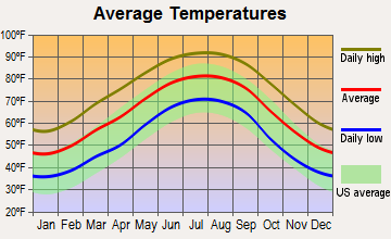
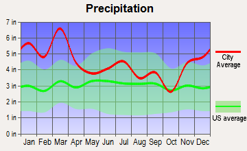
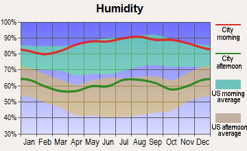
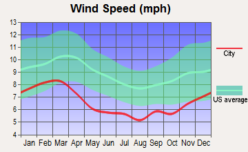
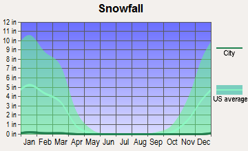
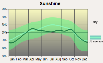
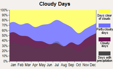
Average climate in Sardis, Alabama
Based on data reported by over 4,000 weather stations
|
|

Tornado activity:
Sardis-area historical tornado activity is below Alabama state average. It is 32% greater than the overall U.S. average.
On 3/1/2007, a category F4 (max. wind speeds 207-260 mph) tornado 25.0 miles away from the Sardis place center killed one person and injured 2 people and caused $2 million in damages.
On 12/6/1983, a category F3 (max. wind speeds 158-206 mph) tornado 9.3 miles away from the place center killed one person and injured 19 people and caused between $500,000 and $5,000,000 in damages.
Earthquake activity:
Sardis-area historical earthquake activity is significantly above Alabama state average. It is 86% greater than the overall U.S. average.On 10/24/1997 at 08:35:17, a magnitude 4.9 (4.8 MB, 4.2 MS, 4.9 LG, Depth: 6.2 mi, Class: Light, Intensity: IV - V) earthquake occurred 80.8 miles away from the city center
On 1/18/1999 at 07:00:53, a magnitude 4.8 (4.8 MB, 4.0 LG, Depth: 0.6 mi) earthquake occurred 79.5 miles away from Sardis center
On 4/29/2003 at 08:59:39, a magnitude 4.9 (4.4 MB, 4.6 MW, 4.9 LG) earthquake occurred 173.5 miles away from Sardis center
On 11/7/2004 at 11:20:21, a magnitude 4.3 (4.3 MW, Depth: 3.1 mi) earthquake occurred 59.2 miles away from Sardis center
On 6/24/1975 at 11:11:36, a magnitude 4.5 (4.5 MB) earthquake occurred 110.7 miles away from Sardis center
On 4/29/2003 at 08:59:39, a magnitude 4.6 (4.6 MW, Depth: 12.3 mi) earthquake occurred 173.4 miles away from the city center
Magnitude types: regional Lg-wave magnitude (LG), body-wave magnitude (MB), surface-wave magnitude (MS), moment magnitude (MW)
Natural disasters:
The number of natural disasters in Dallas County (19) is greater than the US average (15).Major Disasters (Presidential) Declared: 11
Emergencies Declared: 5
Causes of natural disasters: Storms: 10, Floods: 8, Tornadoes: 7, Hurricanes: 6, Winds: 3, Drought: 1, Snowfall: 1, Winter Storm: 1, Other: 1 (Note: some incidents may be assigned to more than one category).
Hospitals and medical centers near Sardis:
- WARREN MANOR HEALTH AND REHABILITATION CENTER (Nursing Home, about 11 miles away; SELMA, AL)
- FMC SELMA (Dialysis Facility, about 11 miles away; SELMA, AL)
- VAUGHAN REG MED CENTER PARKWAY CAMPUS Acute Care Hospitals (about 11 miles away; SELMA, AL)
- FMC DALLAS COUNTY (Dialysis Facility, about 12 miles away; SELMA, AL)
- PARK PLACE NURSING AND REHABILITATION CENTER, LLC (Nursing Home, about 12 miles away; SELMA, AL)
- FMC VALLEY CREEK (Dialysis Facility, about 12 miles away; SELMA, AL)
- LIGHTHOUSE REHABILITATION AND HEALTHCARE CENTER (Nursing Home, about 12 miles away; SELMA, AL)
Colleges/universities with over 2000 students nearest to Sardis:
- Alabama State University (about 43 miles; Montgomery, AL; Full-time enrollment: 5,457)
- Faulkner University (about 48 miles; Montgomery, AL; FT enrollment: 2,887)
- Auburn University at Montgomery (about 50 miles; Montgomery, AL; FT enrollment: 4,092)
- University of Montevallo (about 59 miles; Montevallo, AL; FT enrollment: 2,826)
- Shelton State Community College (about 67 miles; Tuscaloosa, AL; FT enrollment: 4,106)
- Troy University (about 71 miles; Troy, AL; FT enrollment: 16,148)
- University of West Alabama (about 72 miles; Livingston, AL; FT enrollment: 3,394)
Points of interest:
Notable locations in Sardis: Kings Landing (A), Sardis Volunteer Fire Department (B). Display/hide their locations on the map
Churches in Sardis include: New Bride Church (A), Shady Grove Church (B), Shiloh Church (C), Shiloh Baptist Church (D), Union Church (E), Adams Grove Presbyterian Church (F), Cosey Church (G), East Salem Church (H), Mount Nebo Church (I). Display/hide their locations on the map
Cemeteries: Adams Grove Cemetery (1), Mount Olive Cemetery (2), King Cemetery (3), Mount Leveton Cemetery (4), Shiloh Cemetery (5). Display/hide their locations on the map
Reservoirs and swamps: Plummer Lake (A), Titi Swamp (B). Display/hide their locations on the map
Streams, rivers, and creeks: Steep Creek (A), Sorrell Branch (B), Mountain Branch (C), Lias Creek (D), King Mill Branch (E), Cook Branch (F), Berlin Branch (G). Display/hide their locations on the map
Parks in Sardis include: Six Mile Creek Public Use Area (1), Kings Landing Public Use Area (2). Display/hide their locations on the map
Drinking water stations with addresses in Sardis and their reported violations in the past:
SOUTH DALLAS WATER AUTHORITY (Population served: 3,669, Groundwater):Past monitoring violations:
- One minor monitoring violation
| This place: | 2.4 people |
| Alabama: | 2.5 people |
| This place: | 66.8% |
| Whole state: | 67.8% |
| This place: | 5.5% |
| Whole state: | 4.7% |
Likely homosexual households (counted as self-reported same-sex unmarried-partner households)
- Lesbian couples: 0.2% of all households
- Gay men: 0.4% of all households
| This place: | 30.2% |
| Whole state: | 16.1% |
| This place: | 7.8% |
| Whole state: | 7.3% |
For population 15 years and over in Sardis:

- Never married: 34.8%
- Now married: 48.8%
- Separated: 2.4%
- Widowed: 13.5%
- Divorced: 2.9%
For population 25 years and over in Sardis:
- High school or higher: 58.0%
- Bachelor's degree or higher: 8.8%
- Graduate or professional degree: 3.4%
- Unemployed: 11.5%
- Mean travel time to work (commute): 33.1 minutes


| Here: | 16.0 |
| Alabama average: | 13.2 |
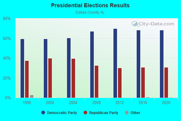
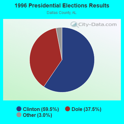
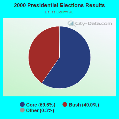
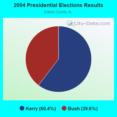

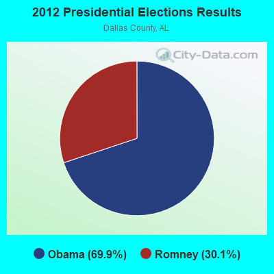
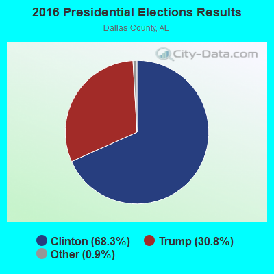
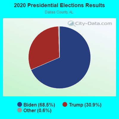
Graphs represent county-level data. Detailed 2008 Election Results
Religion statistics for Sardis, AL (based on Dallas County data)
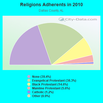
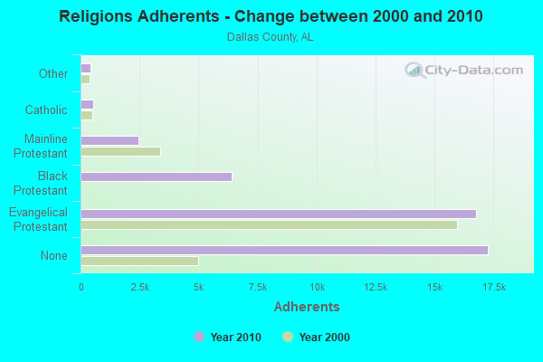
| Religion | Adherents | Congregations |
|---|---|---|
| Evangelical Protestant | 16,764 | 73 |
| Black Protestant | 6,398 | 34 |
| Mainline Protestant | 2,438 | 26 |
| Catholic | 536 | 2 |
| Other | 410 | 5 |
| None | 17,274 | - |
Food Environment Statistics:
| Dallas County: | 2.56 / 10,000 pop. |
| State: | 1.89 / 10,000 pop. |
| Dallas County: | 0.23 / 10,000 pop. |
| State: | 0.20 / 10,000 pop. |
| Dallas County: | 0.93 / 10,000 pop. |
| State: | 0.65 / 10,000 pop. |
| Here: | 9.54 / 10,000 pop. |
| Alabama: | 6.32 / 10,000 pop. |
| Dallas County: | 3.95 / 10,000 pop. |
| State: | 5.75 / 10,000 pop. |
| Dallas County: | 15.1% |
| Alabama: | 11.8% |
| Here: | 41.2% |
| Alabama: | 31.7% |
| Here: | 8.9% |
| Alabama: | 13.5% |
Strongest AM radio stations in Sardis:
- WJOX (690 AM; 50 kW; BIRMINGHAM, AL; Owner: CITADEL BROADCASTING COMPANY)
- WMRK (1340 AM; 1 kW; SELMA, AL; Owner: ALEXANDER B/C CO. INC.)
- WDJC (850 AM; 50 kW; BIRMINGHAM, AL; Owner: KIMTRON, INC.)
- WAPI (1070 AM; 50 kW; BIRMINGHAM, AL; Owner: CITADEL BROADCASTING COMPANY)
- WHBB (1490 AM; 1 kW; SELMA, AL; Owner: BROADSOUTH COMMUNICATIONS, INC.)
- WMSP (740 AM; 10 kW; MONTGOMERY, AL; Owner: CUMULUS LICENSING CORP.)
- WASG (550 AM; 25 kW; ATMORE, AL; Owner: 550 AM, INC)
- WJUS (1310 AM; 5 kW; MARION, AL; Owner: GRACE BAPTIST TEMPLE CHURCH)
- WACV (1170 AM; 10 kW; MONTGOMERY, AL; Owner: MONTGOMERY BROADCAST PROPERTIES, LTD)
- WNSI (810 AM; 50 kW; JACKSONVILLE, AL; Owner: UNITED BROADCASTING NETWORK, INC.)
- WSJC (810 AM; 50 kW; MAGEE, MS; Owner: FAMILY TALK RADIO)
- WKNG (1060 AM; daytime; 50 kW; TALLAPOOSA, GA; Owner: WKNG, INC.)
- WGST (640 AM; 50 kW; ATLANTA, GA; Owner: CITICASTERS LICENSES, L.P.)
Strongest FM radio stations in Sardis:
- WALX (100.9 FM; SELMA, AL; Owner: ALEXANDER BROADCASTING COMPANY, INC.)
- WAPR (88.3 FM; SELMA, AL; Owner: UA-ASU-TSU EDUCATIONAL RADIO CORP.)
- WJAM-FM (97.3 FM; ORRVILLE, AL; Owner: SCOTT COMMUNICATIONS, INC.)
- WBFZ (105.3 FM; SELMA, AL; Owner: IMANI COMMUNICATIONS CORPORATION, INC)
- WDXX (100.1 FM; SELMA, AL; Owner: BROADSOUTH COMMUNICATIONS, INC.)
- WAQU (91.1 FM; SELMA, AL; Owner: AMERICAN FAMILY ASSOCIATION)
- WLWI-FM (92.3 FM; MONTGOMERY, AL; Owner: CUMULUS LICENSING CORP.)
- WQLD (104.3 FM; LUVERNE, AL; Owner: CAPSTAR TX LIMITED PARTNERSHIP)
- WZHT (105.7 FM; TROY, AL; Owner: CAPSTAR TX LIMITED PARTNERSHIP)
- WMXS (103.3 FM; MONTGOMERY, AL; Owner: CUMULUS LICENSING CORP.)
- WVFG (107.5 FM; UNIONTOWN, AL; Owner: CHARLES E. JONES, JR.)
- W232AN (94.3 FM; SELMA, AL; Owner: THE MOODY BIBLE INSTITUTE OF CHICAGO)
TV broadcast stations around Sardis:
- WAKA (Channel 8; SELMA, AL; Owner: ALABAMA BROADCASTING PARTNERS)
- WBIH (Channel 29; SELMA, AL; Owner: FLINN BROADCASTING CORPORATION)
- W24CK (Channel 24; SELMA, AL; Owner: TRINITY BROADCASTING NETWORK)
- WNCF (Channel 32; MONTGOMERY, AL; Owner: CHANNEL 32 MONTGOMERY LLC)
- WRJM-TV (Channel 67; TROY, AL; Owner: JOSIE PARK BROADCASTING, INC.)
- WSFA (Channel 12; MONTGOMERY, AL; Owner: LIBCO, INC.)
- WCOV-TV (Channel 20; MONTGOMERY, AL; Owner: WOODS COMMUNICATIONS CORPORATION)
Sardis fatal accident list:
Jan 25, 1998 01:15 AM, Us-Sr1, Vehicles: 1, Persons: 1, Fatalities: 1
Jul 18, 1996 05:34 PM, 1211, Vehicles: 3, Persons: 3, Fatalities: 2
Aug 15, 1996 12:15 AM, 1211, Vehicles: 1, Persons: 1, Fatalities: 1
Jul 4, 1988 10:36 PM, Sr1, Vehicles: 2, Persons: 6, Fatalities: 1, Drunk persons involved: 1
FCC Registered Antenna Towers:
57 (See the full list of FCC Registered Antenna Towers in Sardis)FCC Registered Broadcast Land Mobile Towers:
3- Sardis City Hall (Lat: 34.173694 Lon: -86.124694), Call Sign: KVI578, Licensee ID: L00564294,
Assigned Frequencies: 155.010 MHz, Grant Date: 08/30/2002, Expiration Date: 11/05/2012, Cancellation Date: 01/05/2013, Registrant: City Of Sardis, 1335 Sardis Dr, Sardis City, AL 35956
- Kings Landing (Lat: 32.175694 Lon: -87.008611), Call Sign: WRL872,
Assigned Frequencies: 31.6800 MHz, Grant Date: 06/22/1999, Expiration Date: 08/23/2004, Cancellation Date: 05/17/2002, Registrant: O W Till Jr, 417 County Rd 30, Sardis, AL 36775, Phone: (205) 874-7881
- CR 67 PRV, Water Prv Pit Located On Cr 67 (Lat: 32.276667 Lon: -86.949722), Type: Pipe, Structure height: 6 m, Call Sign: WQHA948,
Assigned Frequencies: 173.362 MHz, Grant Date: 06/15/2017, Expiration Date: 06/14/2027, Certifier: Teddy Pouncey, Registrant: Duke Instrument Service, Saraland, AL 36571-3016, Phone: (251) 675-6067, Fax: (251) 675-5938, Email:
FCC Registered Microwave Towers:
2- SARDIS, Off Of Country Road 30 (Lat: 32.285000 Lon: -86.997722), Type: Ltower, Structure height: 76 m, Overall height: 78 m, Call Sign: WRBQ594,
Assigned Frequencies: 11385.0 MHz, 11425.0 MHz, 11385.0 MHz, 11425.0 MHz, 11385.0 MHz, 11425.0 MHz, 11385.0 MHz, 11425.0 MHz, 11385.0 MHz, 11425.0 MHz... (+6 more), Grant Date: 05/22/2018, Expiration Date: 05/22/2028, Certifier: Larry F Butts, Registrant: Southern Company Services, 600 N. 18th St / Bin 5n-5409, Birmingham, AL 35203, Phone: (205) 257-7600, Fax: (205) 257-2134, Email:
- SARDIS, Hwy 41 And Cr 85 (#28123) (Lat: 32.230778 Lon: -86.987194), Type: Gtower, Structure height: 91.4 m, Overall height: 93.9 m, Call Sign: WRER855,
Assigned Frequencies: 6815.00 MHz, 6815.00 MHz, 6815.00 MHz, 6815.00 MHz, 6815.00 MHz, 6815.00 MHz, 6815.00 MHz, Grant Date: 12/10/2019, Expiration Date: 12/10/2029, Certifier: John Nettles, Registrant: Monte R. Lee & Company, 525 Central Park Drive, Suite 300, Oklahoma City, OK 73105, Phone: (405) 842-2405, Email:
FCC Registered Amateur Radio Licenses:
2- Call Sign: KD4TTH, Licensee ID: L00593191, Grant Date: 07/31/2002, Expiration Date: 10/13/2012, Cancellation Date: 10/15/2014, Certifier: Ronald S Wilson, Registrant: Ronald S Wilson, 166 Sunrise Drive, Sardis, AL 35956
- Call Sign: KG4PKL, Licensee ID: L00404311, Grant Date: 04/15/2022, Expiration Date: 04/15/2032, Certifier: Nicholas D Switzer, Registrant: Nicholas D Switzer, 6261 Al Hwy 41, Sardis, AL 36775
2005 - 2017 National Fire Incident Reporting System (NFIRS) incidents
- Fire incident types reported to NFIRS in Sardis, AL
- 9958.6%Outside Fires
- 4426.0%Structure Fires
- 2514.8%Mobile Property/Vehicle Fires
- 10.6%Other
 Based on the data from the years 2005 - 2017 the average number of fires per year is 13. The highest number of fire incidents - 22 took place in 2006, and the least - 3 in 2016. The data has a decreasing trend.
 When looking into fire subcategories, the most incidents belonged to: Outside Fires (58.6%), and Structure Fires (26.0%).
- 54.6%Bottled, tank, or LP gas
- 22.5%Electricity
- 19.5%Utility gas
- 2.1%Wood
- 1.3%Fuel oil, kerosene, etc.

- 84.5%Bottled, tank, or LP gas
- 8.2%Electricity
- 7.2%Wood
Sardis compared to Alabama state average:
- Median house value below state average.
- Black race population percentage above state average.
- Hispanic race population percentage significantly below state average.
- Foreign-born population percentage significantly below state average.
- Renting percentage below state average.
- Length of stay since moving in significantly above state average.
- Number of rooms per house significantly below state average.
- House age significantly below state average.
- Percentage of population with a bachelor's degree or higher below state average.
Sardis on our top lists:
- #72 on the list of "Top 101 larger cities with the lowest real estate taxes percentage (population 50,000+)"
- #85 on the list of "Top 101 cities with the least cars per house, population 500+"
- #80 (36775) on the list of "Top 101 zip codes with the lowest 2012 average reported profit/loss from business (pop 1,000+)"