Sanderson, Florida
Submit your own pictures of this place and show them to the world
- OSM Map
- General Map
- Google Map
- MSN Map

| Males: 6,790 | |
| Females: 5,441 |
| Median resident age: | 32.9 years |
| Florida median age: | 38.7 years |
Zip code: 32087
| Sanderson: | $68,755 |
| FL: | $69,303 |
Estimated per capita income in 2022: $27,132 (it was $13,870 in 2000)
Sanderson CCD income, earnings, and wages data
Estimated median house or condo value in 2022: $223,372 (it was $60,700 in 2000)
| Sanderson: | $223,372 |
| FL: | $354,100 |
Mean prices in 2022: all housing units: $222,242; detached houses: $286,431; townhouses or other attached units: $139,324; mobile homes: $99,935
Detailed information about poverty and poor residents in Sanderson, FL


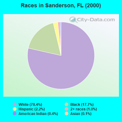
- 8,38178.4%White alone
- 1,89617.7%Black alone
- 2372.2%Hispanic
- 1081.0%Two or more races
- 460.4%American Indian alone
- 150.1%Asian alone
- 30.03%Native Hawaiian and Other
Pacific Islander alone - 20.02%Other race alone
Races in Sanderson detailed stats: ancestries, foreign born residents, place of birth
According to our research of Florida and other state lists, there were 13 registered sex offenders living in Sanderson, Florida as of May 08, 2024.
The ratio of all residents to sex offenders in Sanderson is 941 to 1.
The ratio of registered sex offenders to all residents in this city is lower than the state average.
 Recent articles from our blog. Our writers, many of them Ph.D. graduates or candidates, create easy-to-read articles on a wide variety of topics.

Current Local Time: EST time zone
Elevation: 156 feet
Land area: 456.0 square miles.
Population density: 27 people per square mile (very low).

| Sanderson CCD: | 1.1% ($686) |
| Florida: | 1.4% ($1,262) |
Nearest city with pop. 50,000+: Jacksonville, FL  (38.5 miles , pop. 735,617).
Nearest city with pop. 1,000,000+: Philadelphia, PA (782.0 miles , pop. 1,517,550).
Nearest cities:
), ), ), )Latitude: 30.31 N, Longitude: 82.30 W
Area code: 904

| Here: | 2.8% |
| Florida: | 2.9% |
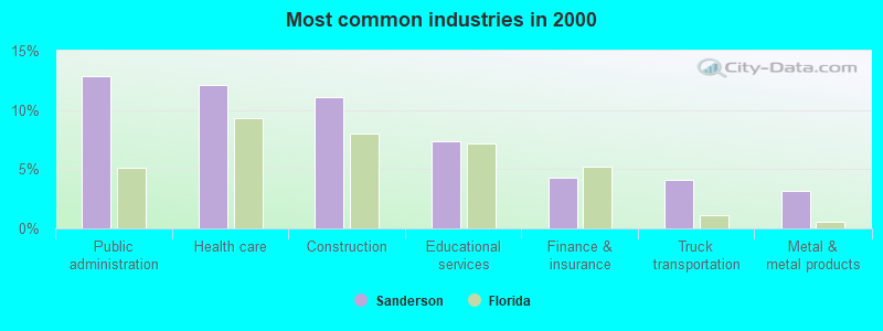
- Public administration (12.8%)
- Health care (12.1%)
- Construction (11.1%)
- Educational services (7.4%)
- Finance & insurance (4.3%)
- Truck transportation (4.1%)
- Metal & metal products (3.2%)
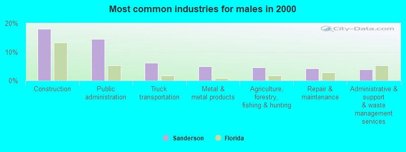
- Construction (18.0%)
- Public administration (14.5%)
- Truck transportation (6.1%)
- Metal & metal products (5.0%)
- Agriculture, forestry, fishing & hunting (4.5%)
- Repair & maintenance (4.2%)
- Administrative & support & waste management services (3.8%)
- Health care (23.5%)
- Educational services (13.0%)
- Public administration (10.6%)
- Finance & insurance (9.1%)
- Social assistance (6.4%)
- Department & other general merchandise stores (4.5%)
- Accommodation & food services (4.2%)
- Law enforcement workers, including supervisors (6.7%)
- Driver/sales workers and truck drivers (5.9%)
- Secretaries and administrative assistants (4.3%)
- Other sales and related occupations, including supervisors (4.1%)
- Other office and administrative support workers, including supervisors (3.9%)
- Building and grounds cleaning and maintenance occupations (3.7%)
- Electrical equipment mechanics and other installation, maintenance, and repair workers, including supervisors (3.5%)
- Driver/sales workers and truck drivers (10.0%)
- Law enforcement workers, including supervisors (10.0%)
- Electrical equipment mechanics and other installation, maintenance, and repair workers, including supervisors (5.9%)
- Laborers and material movers, hand (4.7%)
- Other production occupations, including supervisors (4.4%)
- Construction traders workers except carpenters, electricians, painters, plumbers, and construction laborers (4.4%)
- Supervisors, construction and extraction workers (4.3%)
- Secretaries and administrative assistants (10.1%)
- Other office and administrative support workers, including supervisors (6.8%)
- Nursing, psychiatric, and home health aides (6.4%)
- Other sales and related occupations, including supervisors (6.0%)
- Preschool, kindergarten, elementary, and middle school teachers (4.9%)
- Registered nurses (4.7%)
- Other management occupations, except farmers and farm managers (4.5%)
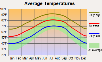
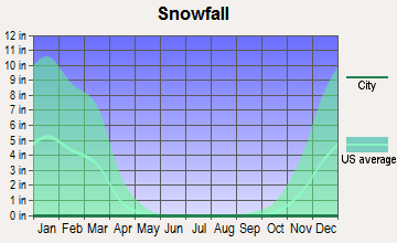
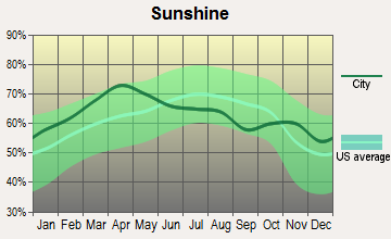
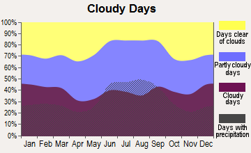
Average climate in Sanderson, Florida
Based on data reported by over 4,000 weather stations
(lower is better)
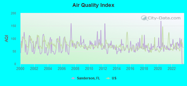
Air Quality Index (AQI) level in 2022 was 74.0. This is about average.
| City: | 74.0 |
| U.S.: | 72.6 |
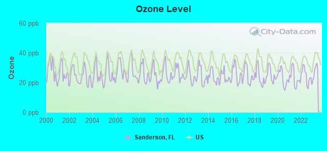
Ozone [ppb] level in 2022 was 24.2. This is better than average. Closest monitor was 11.3 miles away from the city center.
| City: | 24.2 |
| U.S.: | 33.3 |
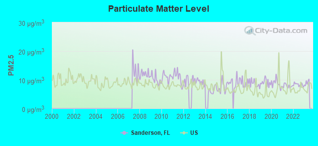
Particulate Matter (PM2.5) [µg/m3] level in 2022 was 8.28. This is about average. There were 0 monitors within city limits.
| City: | 8.28 |
| U.S.: | 8.11 |
Tornado activity:
Sanderson-area historical tornado activity is slightly below Florida state average. It is 15% smaller than the overall U.S. average.
On 2/25/1960, a category F3 (max. wind speeds 158-206 mph) tornado 21.0 miles away from the Sanderson place center caused between $50,000 and $500,000 in damages.
On 5/12/1974, a category F2 (max. wind speeds 113-157 mph) tornado 11.3 miles away from the place center injured one person and caused between $50,000 and $500,000 in damages.
Earthquake activity:
Sanderson-area historical earthquake activity is significantly above Florida state average. It is 80% smaller than the overall U.S. average.On 9/10/2006 at 14:56:08, a magnitude 5.9 (5.9 MB, 5.5 MS, 5.8 MW, Class: Moderate, Intensity: VI - VII) earthquake occurred 385.2 miles away from Sanderson center
On 8/2/1974 at 08:52:09, a magnitude 4.9 (4.3 MB, 4.9 LG, Class: Light, Intensity: IV - V) earthquake occurred 246.4 miles away from the city center
On 11/22/1974 at 05:25:55, a magnitude 4.7 (4.7 MB) earthquake occurred 219.5 miles away from Sanderson center
On 10/24/1997 at 08:35:17, a magnitude 4.9 (4.8 MB, 4.2 MS, 4.9 LG, Depth: 6.2 mi) earthquake occurred 300.6 miles away from Sanderson center
On 8/21/1992 at 16:31:55, a magnitude 4.4 (4.1 MB, 4.1 LG, 4.4 LG, Depth: 6.2 mi) earthquake occurred 228.9 miles away from the city center
On 4/29/2003 at 08:59:39, a magnitude 4.9 (4.4 MB, 4.6 MW, 4.9 LG) earthquake occurred 348.2 miles away from the city center
Magnitude types: regional Lg-wave magnitude (LG), body-wave magnitude (MB), surface-wave magnitude (MS), moment magnitude (MW)
Natural disasters:
The number of natural disasters in Baker County (22) is greater than the US average (15).Major Disasters (Presidential) Declared: 13
Emergencies Declared: 4
Causes of natural disasters: Hurricanes: 7, Fires: 5, Floods: 5, Storms: 4, Tornadoes: 4, Tropical Storms: 4, Winds: 2, Freeze: 1, Other: 1 (Note: some incidents may be assigned to more than one category).
Hospitals and medical centers near Sanderson:
- ED FRASER MEMORIAL HOSPITAL Acute Care Hospitals (about 12 miles away; MACCLENNY, FL)
- FMC - MACCLENNY (Dialysis Facility, about 12 miles away; MACCLENNY, FL)
- W FRANK WELLS NURSING HOME (Nursing Home, about 12 miles away; MACCLENNY, FL)
- MACCLENNY NURSING AND REHAB CENTER (Nursing Home, about 12 miles away; MACCLENNY, FL)
Colleges/universities with over 2000 students nearest to Sanderson:
- Florida Gateway College (about 19 miles; Lake City, FL; Full-time enrollment: 2,179)
- Florida State College at Jacksonville (about 39 miles; Jacksonville, FL; FT enrollment: 21,810)
- Jacksonville University (about 42 miles; Jacksonville, FL; FT enrollment: 3,335)
- Santa Fe College (about 45 miles; Gainesville, FL; FT enrollment: 11,819)
- University of Florida (about 47 miles; Gainesville, FL; FT enrollment: 43,357)
- University of North Florida (about 48 miles; Jacksonville, FL; FT enrollment: 13,870)
- Saint Johns River State College (about 60 miles; Palatka, FL; FT enrollment: 4,698)
Points of interest:
Notable locations in Sanderson: Pleasant Grove Church (A), Reddish Millsite (B), Seventeenmile Camp (C), Interstate 10 Rest Area North (D), Interstate 10 Rest Area South (E), East Tower Hunt Camp (F), Big Camp Hunt Camp (G), Boat Basin Hunt Camp (H), Ocean Pond Campground (I), Cobb Hunt Camp (J), Olustee Beach Picnic Ground (K), Osceola Ranger Office (L), Baker County Fire Department Station 80 Olustee (M), Baker County Fire Department Station 40 Taylor (N), Baker County Fire Department / Baker County Emergency Services Station 70 (O), Baker County Fire Department Station 50 Glen Saint Mary (P), Baker County Fire Department Station 30 Cuyler (Q), Baker County Fire Department Station 60 Baxter (R). Display/hide their locations on the map
Churches in Sanderson include: Saint Johns Church (A), Dinkins New Congregational Methodist Church (B), Oak Grove Church (C), Pine Level Church (D), Pine Grove Church (E), North Prong Church (F), Kingdom Hall of Jehovahs Witnesses (G), Cedar Creek Church (H), Bethlehem Church (I). Display/hide their locations on the map
Cemeteries: Monument Cemetery (1), Turner Cemetery (2), Dyess Cemetery (3), Cedar Creek Cemetery (4), Sanderson Cemetery (5). Display/hide their locations on the map
Lakes, reservoirs, and swamps: Lake Holes (A), Water Hole (B), Ocean Pond (C), Big Gum Swamp (D), Moccasin Swamp (E), Scout Pond (F), Wampee Bay (G), Surveyors Bay (H). Display/hide their locations on the map
Streams, rivers, and creeks: South Prong Saint Marys River (A), Rudy Branch (B), Otter Drain (C), Maple Head Creek (D), Little River (E), Gum Swamp Creek (F), Moccasin Creek (G), Daugherty Branch (H), Calkins Creek (I). Display/hide their locations on the map
Parks in Sanderson include: Olustee Battlefield Historic State Park (1), Lake Butler Wildlife Management Area (2), Osceola Natural Area (3), Osceola Wildlife Management Area (4). Display/hide their locations on the map
Drinking water stations with addresses in Sanderson and their reported violations in the past:
OCEAN POND CAMPGROUND (Population served: 100, Groundwater):Past monitoring violations:OLUSTEE DISTRICT RANGER STATION (Population served: 30, Groundwater):
- Failure to Conduct Assessment Monitoring - Between APR-2012 and JUN-2012, Contaminant: E. COLI. Follow-up actions: St Public Notif requested (AUG-07-2012), St Public Notif received (AUG-22-2012)
- 2 routine major monitoring violations
- 3 minor monitoring violations
- One regular monitoring violation
Past monitoring violations:OLUSTEE BEACH (Population served: 25, Groundwater):
- Failure to Conduct Assessment Monitoring - Between APR-2012 and JUN-2012, Contaminant: E. COLI. Follow-up actions: St Public Notif requested (AUG-07-2012), St Public Notif received (AUG-22-2012)
- 2 routine major monitoring violations
- 3 minor monitoring violations
- One regular monitoring violation
Past monitoring violations:OLUSTEE DEPOT (Population served: 25, Groundwater):
- Failure to Conduct Assessment Monitoring - Between APR-2012 and JUN-2012, Contaminant: E. COLI. Follow-up actions: St Public Notif requested (AUG-07-2012), St Public Notif received (AUG-22-2012)
- 2 routine major monitoring violations
- 4 minor monitoring violations
- One regular monitoring violation
Past monitoring violations:
- Failure to Conduct Assessment Monitoring - Between APR-2012 and JUN-2012, Contaminant: E. COLI. Follow-up actions: St Public Notif requested (AUG-07-2012), St Public Notif received (AUG-22-2012)
- 2 routine major monitoring violations
- 3 minor monitoring violations
- One regular monitoring violation
Drinking water stations with addresses in Sanderson that have no violations reported:
- TAYLOR CHURCH (Population served: 200, Primary Water Source Type: Groundwater)
| This place: | 2.9 people |
| Florida: | 2.5 people |
| This place: | 78.1% |
| Whole state: | 65.2% |
| This place: | 7.0% |
| Whole state: | 7.3% |
Likely homosexual households (counted as self-reported same-sex unmarried-partner households)
- Lesbian couples: 0.3% of all households
- Gay men: 0.4% of all households
| This place: | 15.3% |
| Whole state: | 12.5% |
| This place: | 7.0% |
| Whole state: | 5.7% |
20 people in workers' group living quarters and job corps centers in 2010
1,240 people in state prisons in 2000
44 people in other group homes in 2000
For population 15 years and over in Sanderson:
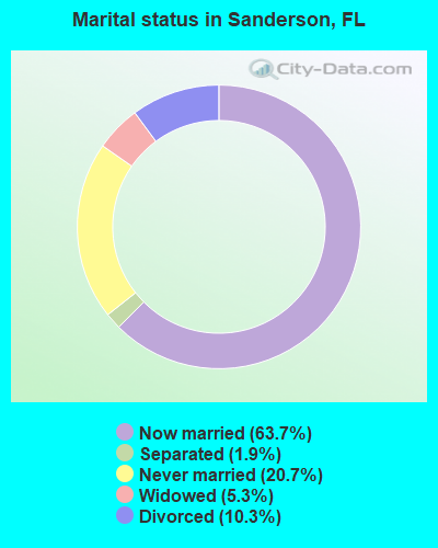
- Never married: 20.7%
- Now married: 63.7%
- Separated: 1.9%
- Widowed: 5.3%
- Divorced: 10.3%
For population 25 years and over in Sanderson:
- High school or higher: 71.8%
- Bachelor's degree or higher: 6.3%
- Graduate or professional degree: 1.9%
- Unemployed: 4.6%
- Mean travel time to work (commute): 34.7 minutes
| Here: | 10.8 |
| Florida average: | 12.6 |
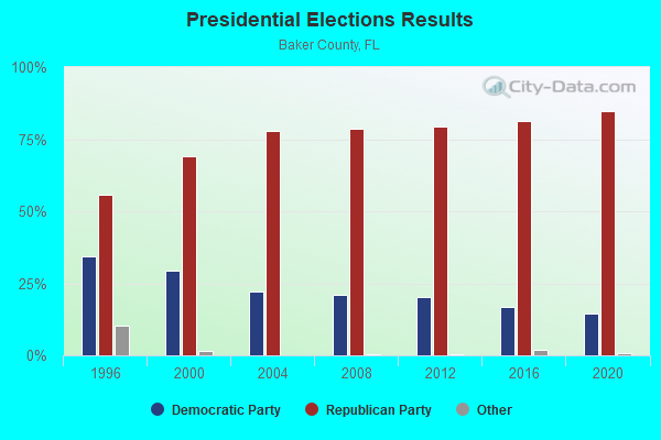
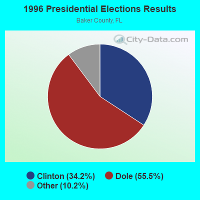
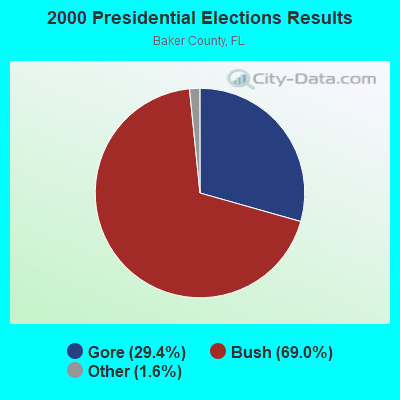
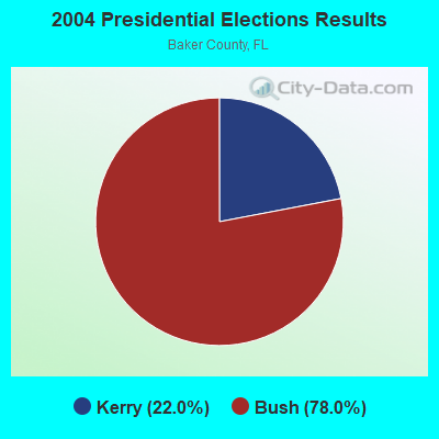
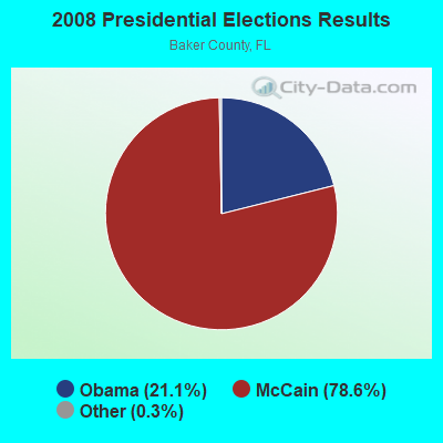

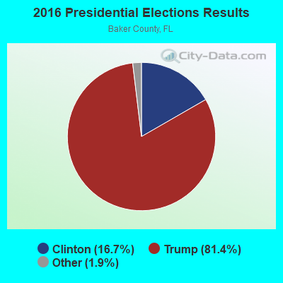
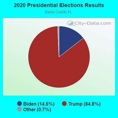
Graphs represent county-level data. Detailed 2008 Election Results
Religion statistics for Sanderson, FL (based on Baker County data)
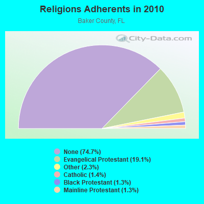
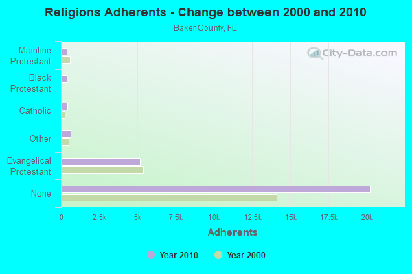
| Religion | Adherents | Congregations |
|---|---|---|
| Evangelical Protestant | 5,186 | 28 |
| Other | 613 | 2 |
| Catholic | 383 | 1 |
| Black Protestant | 344 | 4 |
| Mainline Protestant | 339 | 1 |
| None | 20,250 | - |
Food Environment Statistics:
| Baker County: | 1.56 / 10,000 pop. |
| Florida: | 2.04 / 10,000 pop. |
| Here: | 0.78 / 10,000 pop. |
| State: | 1.28 / 10,000 pop. |
| Baker County: | 6.62 / 10,000 pop. |
| Florida: | 3.04 / 10,000 pop. |
| Here: | 3.89 / 10,000 pop. |
| Florida: | 7.45 / 10,000 pop. |
| This county: | 11.9% |
| Florida: | 9.2% |
| Here: | 29.8% |
| State: | 23.7% |
| Baker County: | 11.7% |
| Florida: | 14.0% |
Strongest AM radio stations in Sanderson:
- WOKV (690 AM; 50 kW; JACKSONVILLE, FL; Owner: COX RADIO, INC.)
- WFVR (910 AM; 50 kW; VALDOSTA, GA; Owner: RAMA COMMUNICATIONS, INC.)
- WGSR (1570 AM; 50 kW; FERNANDINA BEACH, FL; Owner: RJM COMMUNICATIONS, INC)
- WOBS (1530 AM; daytime; 50 kW; JACKSONVILLE, FL; Owner: WORD BROADCASTING NETWORK, INC.)
- WBWL (600 AM; 5 kW; JACKSONVILLE, FL)
- WAYR (550 AM; 5 kW; ORANGE PARK, FL; Owner: GOOD TIDINGS TRUST, INC.)
- WIOJ (1010 AM; 10 kW; JACKSONVILLE BEACH, FL)
- WFXJ (930 AM; 5 kW; JACKSONVILLE, FL; Owner: CLEAR CHANNEL BROADCASTING LICENSES, INC.)
- WFLF (540 AM; 50 kW; PINE HILLS, FL; Owner: CLEAR CHANNEL BROADCASTING LICENSES, INC.)
- WROS (1050 AM; 5 kW; JACKSONVILLE, FL; Owner: THE ROSE OF JACKSONVILLE)
- WEWC (1160 AM; 5 kW; CALLAHAN, FL; Owner: CIRCLE BROADCASTING OF AMERICA, INC.)
- WQTM (740 AM; 50 kW; ORLANDO, FL; Owner: CLEAR CHANNEL BROADCASTING LICENSES, INC.)
- WJGR (1320 AM; 5 kW; JACKSONVILLE, FL; Owner: CARON BROADCASTING, INC.)
Strongest FM radio stations in Sanderson:
- WHJX (105.7 FM; BALDWIN, FL; Owner: TAMA GROUP L.L.C.)
- WEJZ (96.1 FM; JACKSONVILLE, FL; Owner: RENDA BROADCASTING CORP. OF NEVADA)
- WAPE-FM (95.1 FM; JACKSONVILLE, FL; Owner: COX RADIO, INC.)
- WWRR (100.7 FM; BRUNSWICK, GA; Owner: RENDA BROADCASTING CORP. OF NEVADA)
- WSOL-FM (101.5 FM; BRUNSWICK, GA; Owner: CITICASTERS LICENSES, L.P.)
- WQLC (102.1 FM; WATERTOWN, FL; Owner: LOUIS D. BOLTON, II)
- WNFB (94.3 FM; LAKE CITY, FL; Owner: NEWMAN MEDIA, INC.)
- WKQL (96.9 FM; JACKSONVILLE, FL; Owner: COX RADIO, INC.)
- WJXR (92.1 FM; MACCLENNY, FL; Owner: WJXR, INC.)
- WYFB (90.5 FM; GAINESVILLE, FL; Owner: BIBLE BROADCASTING NETWORK, INC.)
- WQPW (95.7 FM; VALDOSTA, GA; Owner: RTG RADIO, LLC)
- WQIK-FM (99.1 FM; JACKSONVILLE, FL; Owner: CITICASTERS LICENSES, L.P.)
- WFYV-FM (104.5 FM; ATLANTIC BEACH, FL; Owner: COX RADIO, INC.)
- WMXQ (102.9 FM; JACKSONVILLE, FL; Owner: COX RADIO, INC.)
- WFKS (97.9 FM; NEPTUNE BEACH, FL; Owner: CLEAR CHANNEL BROADCASTING LICENSES, INC.)
- WROO (107.3 FM; JACKSONVILLE, FL; Owner: CLEAR CHANNEL BROADCASTING LICENSES, INC.)
- WEAG-FM (106.3 FM; STARKE, FL; Owner: DICKERSON BROADCASTING, INC.)
- WCJX (106.5 FM; FIVE POINTS, FL; Owner: RTG RADIO, LLC)
TV broadcast stations around Sanderson:
- WFXU (Channel 57; LIVE OAK, FL; Owner: WFXU LICENSE CORPORATION)
- WJWB (Channel 17; JACKSONVILLE, FL; Owner: MEDIA GENERAL COMMUNICATIONS, INC.)
- WJCT (Channel 7; JACKSONVILLE, FL; Owner: WJCT, INC.)
- WPXC-TV (Channel 21; BRUNSWICK, GA; Owner: PAXSON JAX LICENSE, INC.)
- WAWS (Channel 30; JACKSONVILLE, FL; Owner: CLEAR CHANNEL BROADCASTING LICENSES, INC.)
- WJEB-TV (Channel 59; JACKSONVILLE, FL; Owner: JACKSONVILLE EDUCATORS BROADCASTING, INC.)
- WTEV-TV (Channel 47; JACKSONVILLE, FL; Owner: CLEAR CHANNEL BROADCASTING LICENSES, INC.)
- W23AQ (Channel 23; LAKE CITY, FL; Owner: TRINITY BROADCASTING NETWORK)
FCC Registered Cell Phone Towers:
4 (See the full list of FCC Registered Cell Phone Towers in Sanderson)FCC Registered Antenna Towers:
64 (See the full list of FCC Registered Antenna Towers)FCC Registered Broadcast Land Mobile Towers:
6- Int Rt I10 And Us90 (Lat: 30.237778 Lon: -82.303889), Type: Tower, Structure height: 79.9 m, Overall height: 81.9 m, Call Sign: WBY436,
Assigned Frequencies: 75.6200 MHz, Grant Date: 05/24/2014, Expiration Date: 08/19/2024, Registrant: State Of Florida, 605 Suwannee St., Ms 90, Tallahassee, FL 32399-0450, Phone: (850) 410-5600, Fax: (850) 410-5501, Email:
- 645 Meters W Of Sr 90 & Cr 231 Int (Lat: 30.204667 Lon: -82.435111), Type: Pole, Structure height: 14 m, Overall height: 17 m, Call Sign: WPPF580,
Assigned Frequencies: 896.887 MHz, 896.937 MHz, 896.987 MHz, 897.887 MHz, 897.937 MHz, 897.987 MHz, Grant Date: 11/26/1999, Expiration Date: 11/26/2004, Cancellation Date: 01/29/2005, Certifier: Robert Vandeberg, Registrant: Transportation Technology Center Inc, 55500 Dot Rd, Pueblo, CO 81001, Fax: (719) 584-7145
- 645 M W Of Sr 90 & Cr 231 (Lat: 30.204667 Lon: -82.435111), Type: Pole, Structure height: 14 m, Call Sign: WPPH266,
Assigned Frequencies: 160.230 MHz, 160.785 MHz, 161.100 MHz, Grant Date: 10/09/2014, Expiration Date: 12/21/2024, Certifier: L W Allen, Registrant: Csx Transportation, 6735 Southpoint Dr. S, 4th Flr J958, Jacksonville, FL 32216, Phone: (904) 332-5925, Fax: (904) 332-6013, Email:
- Csxt Mp Sp 670.7 Ne Cor Of Sr 229 & Csxt R O W (Lat: 30.253028 Lon: -82.272056), Type: Pole, Structure height: 14 m, Overall height: 20 m, Call Sign: WSX608,
Assigned Frequencies: 160.785 MHz, 160.590 MHz, 161.100 MHz, 161.370 MHz, 161.520 MHz, Grant Date: 11/07/2014, Expiration Date: 01/10/2025, Certifier: L W Allen, Registrant: Csx Transportation Inc, 6735 Southpoint Dr. S, 4th Flr J958, Jacksonville, FL 32216, Phone: (904) 332-5925, Fax: (904) 332-6013, Email:
- SANDERSON, .5m Ne I-95 & Us 90, 20m W (Lat: 30.240417 Lon: -82.301417), Type: Ltower, Structure height: 103.9 m, Overall height: 105.8 m, Call Sign: WQRQ544,
Assigned Frequencies: 854.662 MHz, 856.137 MHz, 857.587 MHz, 858.112 MHz, 858.512 MHz, Grant Date: 04/12/2023, Expiration Date: 07/09/2033, Certifier: Charles Hadley, Registrant: Dms-Divtel-Slers, 4030 Esplanade Way, Suite 135j, Tallahassee, FL 32399-0950, Phone: (850) 487-0544, Email:
- Lat: 30.253500 Lon: -82.253528, Call Sign: WRMY590,
Assigned Frequencies: 151.685 MHz, 151.835 MHz, 151.925 MHz, 158.385 MHz, Grant Date: 06/24/2021, Expiration Date: 06/24/2031, Certifier: Mose Daniel, Registrant: Murphy Communications Inc, 2230 Jernigan Road, Jacksonville, FL 32207, Phone: (904) 398-2984, Email:
FCC Registered Microwave Towers:
7- 303046, Hwy 90 & Hwy 250a (303046) (Lat: 30.212861 Lon: -82.411556), Type: Tower, Structure height: 61 m, Overall height: 63.7 m, Call Sign: WQNY697,
Assigned Frequencies: 11345.0 MHz, 6197.24 MHz, 11345.0 MHz, 6197.24 MHz, 11345.0 MHz, 6197.24 MHz, 11345.0 MHz, 6197.24 MHz, 11345.0 MHz, Grant Date: 07/11/2011, Expiration Date: 07/11/2021, Cancellation Date: 10/09/2021, Certifier: Pat Lien, Registrant: North Florida Broadband Authority, 1 Courthouse Circle, Monticello, FL 32344, Phone: (850) 342-0218, Fax: (850) 342-0222, Email:
- 88468, 17088 Us 90 (Lat: 30.233472 Lon: -82.317111), Type: Tower, Structure height: 76.2 m, Overall height: 79.3 m, Call Sign: WQNY925,
Assigned Frequencies: 10735.0 MHz, 10855.0 MHz, 10735.0 MHz, 10855.0 MHz, 10735.0 MHz, 10855.0 MHz, 10735.0 MHz, 10855.0 MHz, 10735.0 MHz, 10855.0 MHz, Grant Date: 07/13/2011, Expiration Date: 07/13/2021, Cancellation Date: 10/09/2021, Certifier: Pat Lien, Registrant: North Florida Broadband Authority, 1 Courthouse Circle, Monticello, FL 32344, Phone: (850) 342-0218, Fax: (850) 342-0222, Email:
- SANDERSON, Int Of I10 & Us 90 Sw Quadrant Exit 45 (Lat: 30.237778 Lon: -82.303889), Type: Tower, Structure height: 79.9 m, Overall height: 81.9 m, Call Sign: WQOC902,
Assigned Frequencies: 942.575 MHz, Grant Date: 05/22/2021, Expiration Date: 08/16/2031, Certifier: David Richardson, Registrant: The Semaphore Group, 229 South 5th Street, Fernandina Beach, FL 32034, Phone: (904) 261-0050, Fax: (904) 277-3546, Email:
- SANDERSON, .5m Ne I-95 & Us 90, 20m W (Lat: 30.240417 Lon: -82.301417), Type: Ltower, Structure height: 103.9 m, Overall height: 105.8 m, Call Sign: WQWC395,
Assigned Frequencies: 6590.62 MHz, Grant Date: 07/15/2015, Expiration Date: 07/15/2025, Certifier: Nilsa Y Brown Esq, Registrant: Holland & Knight LLP, 800 17th Street, Nw, Suite 1100, Washington, DC 20006, Phone: (202) 862-5965, Fax: (202) 955-5564, Email:
- 9JK2709S, Hwy 90 & Hwy 250a (303046) (Lat: 30.212861 Lon: -82.411556), Type: Gtower, Structure height: 61 m, Overall height: 63.7 m, Call Sign: WRYR676,
Assigned Frequencies: 10755.0 MHz, 10915.0 MHz, 10755.0 MHz, 10915.0 MHz, 10755.0 MHz, 10915.0 MHz, 10755.0 MHz, 10915.0 MHz, 10755.0 MHz, 10915.0 MHz... (+12 more), Grant Date: 09/11/2023, Expiration Date: 09/11/2033, Certifier: Jenny Knopf, Registrant: T-Mobile Usa, Inc., 12920 Se 38th Street, Bellevue, WA 98006, Phone: (425) 383-8401, Fax: (425) 383-4040, Email:
- Sanderson, Se Quadrant Of Us 90 & I 10 Int (Lat: 30.237778 Lon: -82.303889), Type: Ltower, Structure height: 79.9 m, Overall height: 81.9 m, Call Sign: WBV286,
Assigned Frequencies: 6775.00 MHz, 6835.00 MHz, 6375.14 MHz, 6404.79 MHz, 6725.00 MHz, 6375.14 MHz, 6404.79 MHz, 6725.00 MHz, 6375.14 MHz, 6404.79 MHz... (+24 more), Grant Date: 06/05/2018, Expiration Date: 08/30/2028, Registrant: State Of Florida, 605 Suwannee St., Ms 90, Tallahassee, FL 32399-0450, Phone: (850) 410-5600, Fax: (850) 410-5501, Email:
- SANDERSON, .5m Ne I-95 & Us 90, 20m W (Lat: 30.240278 Lon: -82.301389), Type: Tower, Structure height: 108.2 m, Call Sign: WLN656,
Assigned Frequencies: 6197.24 MHz, 6256.54 MHz, 6197.24 MHz, 6226.89 MHz, 6226.89 MHz, 6256.54 MHz, 6286.19 MHz, 6286.19 MHz, 6315.84 MHz, 6345.49 MHz... (+6 more), Grant Date: 03/06/2001, Expiration Date: 02/01/2011, Cancellation Date: 06/24/2010, Certifier: Carol L Tacker, Registrant: At&t Mobility LLC, 1120 20th Street, Nw, Suite 1000, Washington, DC 20036, Phone: (202) 457-2055, Fax: (202) 457-3074, Email:
FCC Registered Amateur Radio Licenses:
15 (See the full list of FCC Registered Amateur Radio Licenses in Sanderson)FAA Registered Aircraft:
1- Aircraft: PIPER PA-28-140 (Category: Land, Seats: 4, Weight: Up to 12,499 Pounds, Speed: 107 mph), Engine: LYCOMING 0-320 SERIES (180 HP) (Reciprocating)
N-Number: 15298, N15298, N-15298, Serial Number: 28-7425001, Year manufactured: 1973, Airworthiness Date: 05/29/1973, Certificate Issue Date: 07/27/2009
Registrant (Individual): Michael Sean Harris, 10418 Liberty Ln, Sanderson, FL 32087
2002 - 2017 National Fire Incident Reporting System (NFIRS) incidents
- Fire incident types reported to NFIRS in Sanderson, FL
- 38360.8%Outside Fires
- 11618.4%Mobile Property/Vehicle Fires
- 8713.8%Structure Fires
- 447.0%Other
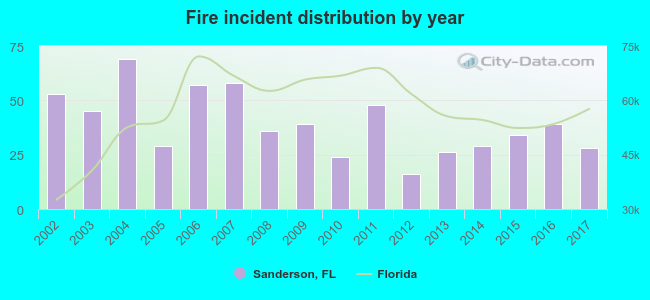 Based on the data from the years 2002 - 2017 the average number of fires per year is 39. The highest number of fires - 69 took place in 2004, and the least - 16 in 2012. The data has a declining trend.
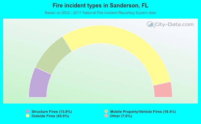 When looking into fire subcategories, the most incidents belonged to: Outside Fires (60.8%), and Mobile Property/Vehicle Fires (18.4%).
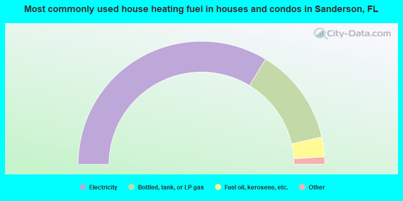
- 67.4%Electricity
- 25.5%Bottled, tank, or LP gas
- 5.2%Fuel oil, kerosene, etc.
- 0.8%Wood
- 0.6%No fuel used
- 0.5%Utility gas
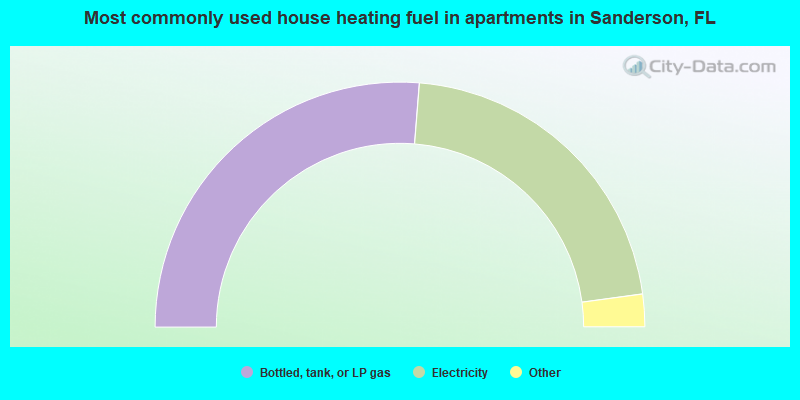
- 52.5%Bottled, tank, or LP gas
- 43.1%Electricity
- 3.3%Fuel oil, kerosene, etc.
- 0.6%No fuel used
- 0.4%Utility gas
Sanderson compared to Florida state average:
- Median house value below state average.
- Unemployed percentage significantly below state average.
- Hispanic race population percentage significantly below state average.
- Median age below state average.
- Foreign-born population percentage significantly below state average.
- Renting percentage below state average.
- Length of stay since moving in significantly above state average.
- Number of rooms per house significantly below state average.
- House age significantly below state average.
- Institutionalized population percentage significantly above state average.
- Number of college students below state average.
- Percentage of population with a bachelor's degree or higher significantly below state average.
Sanderson on our top lists:
- #22 on the list of "Top 101 cities with largest percentage of females in industries: alcoholic beverages merchant wholesalers (population 5,000+)"
- #22 on the list of "Top 101 cities with largest percentage of females in industries: lumber and other construction materials merchant wholesalers (population 5,000+)"
- #23 on the list of "Top 101 cities with largest percentage of females in industries: warehousing and storage (population 5,000+)"
- #26 on the list of "Top 101 cities with largest percentage of females in industries: gasoline stations (population 5,000+)"
- #31 on the list of "Top 101 cities with the largest percentage of mobile homes (2,000+ housing units)"
- #35 on the list of "Top 101 cities with largest percentage of males in occupations: driver/sales workers and truck drivers (population 5,000+)"
- #36 on the list of "Top 101 cities with largest percentage of females in industries: petroleum and coal products (population 5,000+)"
- #38 on the list of "Top 101 cities with largest percentage of males in occupations: supervisors of construction and extraction workers (population 5,000+)"
- #38 on the list of "Top 101 cities with largest percentage of males in industries: truck transportation (population 5,000+)"
- #39 on the list of "Top 101 cities with largest percentage of females in occupations: nursing, psychiatric, and home health aides (population 5,000+)"
- #40 on the list of "Top 101 cities with largest percentage of males in industries: petroleum and coal products (population 5,000+)"
- #41 on the list of "Top 101 cities with largest percentage of females in occupations: carpenters (population 5,000+)"
- #41 on the list of "Top 101 cities with largest percentage of females in industries: health care (population 5,000+)"
- #54 on the list of "Top 101 cities with largest percentage of males in occupations: other construction workers and helpers (population 5,000+)"
- #59 on the list of "Top 101 cities with largest percentage of males in occupations: law enforcement workers including supervisors (population 5,000+)"
- #61 on the list of "Top 101 cities with largest percentage of females in industries: water transportation (population 5,000+)"
- #65 on the list of "Top 101 cities with largest percentage of males in industries: beverage and tobacco products (population 5,000+)"
- #66 on the list of "Top 101 cities with largest percentage of females in industries: building material and garden equipment and supplies dealers (population 5,000+)"
- #66 on the list of "Top 101 cities with largest percentage of males in industries: rail transportation (population 5,000+)"
- #71 on the list of "Top 101 cities with largest percentage of females in industries: social assistance (population 5,000+)"
- #40 on the list of "Top 101 counties with the lowest Ozone (1-hour) air pollution readings in 2012 (ppm)"
- #83 on the list of "Top 101 counties with the smallest number of people without health insurance coverage in 2000"