Samantha, Alabama
Submit your own pictures of this place and show them to the world
- OSM Map
- General Map
- Google Map
- MSN Map

| Males: 2,217 | |
| Females: 2,130 |
| Median resident age: | 34.4 years |
| Alabama median age: | 35.8 years |
Zip code: 35546
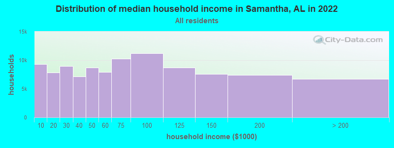
| Samantha: | $69,860 |
| AL: | $59,674 |
Estimated per capita income in 2022: $31,921 (it was $18,216 in 2000)
Samantha CCD income, earnings, and wages data
Estimated median house or condo value in 2022: $236,864 (it was $88,200 in 2000)
| Samantha: | $236,864 |
| AL: | $200,900 |
Mean prices in 2022: all housing units: $274,542; detached houses: $302,362; townhouses or other attached units: $210,995; in 2-unit structures: $86,470; in 3-to-4-unit structures: $67,951; in 5-or-more-unit structures: $151,988; mobile homes: $75,047; occupied boats, rvs, vans, etc.: $32,477
Detailed information about poverty and poor residents in Samantha, AL
Compare current foreclosures near Samantha, AL:
| Photo | Address | Area | Beds / Baths | Price | Details |
|---|---|---|---|---|---|

|
#1
Koffman Ranch Rd
Northport, AL 35475
|
1,372 sq. feet
|
2 baths 3 beds |
$204,900
|
show details |

|
#2
6th Ave
Northport, AL 35473
|
1,527 sq. feet
|
2 baths 3 beds |
show details | |

|
#3
Elam Dr
Northport, AL 35475
|
3,328 sq. feet
|
2 baths 4 beds |
show details | |

|
#4
Longview Dr
Coker, AL 35452
|
1,756 sq. feet
|
2 baths 3 beds |
show details | |

|
#5
Sunrise Cir
Northport, AL 35473
|
1,150 sq. feet
|
2 baths 3 beds |
show details | |

|
#6
Highway 140
Elrod, AL 35458
|
1,249 sq. feet
|
2 baths 3 beds |
show details | |

|
#7
Sleepy Valley Rd
Northport, AL 35475
|
3,222 sq. feet
|
2 baths 5 beds |
show details | |

|
#8
Crosshill Ln
Northport, AL 35473
|
1,776 sq. feet
|
2 baths 3 beds |
show details | |

|
#9
Mayfield Way
Northport, AL 35476
|
1,221 sq. feet
|
1 baths 3 beds |
show details | |

|
#10
Blackstone Ln
Northport, AL 35473
|
1,470 sq. feet
|
1 baths 3 beds |
show details |
| Photo | Address | Area | Beds / Baths | Price | Details |
|---|---|---|---|---|---|

|
#11
Blackstone Ln
Northport, AL 35473
|
1,430 sq. feet
|
1 baths 3 beds |
show details | |

|
#12
Union Chapel Rd
Northport, AL 35473
|
1,818 sq. feet
|
1 baths 3 beds |
show details | |

|
#13
Harper Rd
Northport, AL 35473
|
1,680 sq. feet
|
2 baths 4 beds |
show details | |

|
#14
Sunrise Cir
Northport, AL 35473
|
1,206 sq. feet
|
1 baths 3 beds |
show details | |

|
#15
Wisteria Ln
Northport, AL 35473
|
1,790 sq. feet
|
1 baths 3 beds |
show details | |

|
#16
Vienna Rd
Coker, AL 35452
|
1,567 sq. feet
|
1 baths 3 beds |
show details | |

|
#17
Sexton Bend Rd
Tuscaloosa, AL 35406
|
2,250 sq. feet
|
1 baths 3 beds |
show details | |

|
#18
Tom Montgomery Rd
Northport, AL 35473
|
1,894 sq. feet
|
1 baths 3 beds |
show details | |

|
#19
Edgebrook St
Northport, AL 35475
|
1,487 sq. feet
|
1 baths 3 beds |
show details | |

|
#20
Saint James Ct
Northport, AL 35475
|
2,272 sq. feet
|
2 baths 4 beds |
show details |
| Photo | Address | Area | Beds / Baths | Price | Details |
|---|---|---|---|---|---|

|
#21
Glenfair Cir
Northport, AL 35475
|
2,639 sq. feet
|
2 baths 4 beds |
show details | |

|
#22
Madison Cir
Northport, AL 35475
|
1,390 sq. feet
|
1 baths 3 beds |
show details | |

|
#23
Chestertown Trce
Northport, AL 35475
|
1,598 sq. feet
|
1 baths 3 beds |
show details | |

|
#24
Ross Cir
Northport, AL 35475
|
1,420 sq. feet
|
1 baths 3 beds |
show details | |

|
#25
44th Ave
Northport, AL 35476
|
1,418 sq. feet
|
1 baths 3 beds |
show details | |

|
#26
Lauren St
Northport, AL 35475
|
1,713 sq. feet
|
1 baths 3 beds |
show details | |

|
#27
Stormy Ln
Northport, AL 35473
|
1,624 sq. feet
|
1 baths 3 beds |
show details | |

|
#28
Concord Pl
Northport, AL 35473
|
1,428 sq. feet
|
1 baths 3 beds |
show details | |

|
#29
Hibiscus Ln
Northport, AL 35473
|
1,878 sq. feet
|
1 baths 3 beds |
show details | |

|
#30
Westland Dr
Coker, AL 35452
|
1,539 sq. feet
|
1 baths 3 beds |
show details |
| Photo | Address | Area | Beds / Baths | Price | Details |
|---|---|---|---|---|---|

|
#31
Clearbrook Dr
Northport, AL 35473
|
1,604 sq. feet
|
1 baths 3 beds |
show details | |

|
#32
Thompsons Way
Northport, AL 35473
|
1,282 sq. feet
|
1 baths 3 beds |
show details | |

|
#33
Old Barn Ln
Northport, AL 35473
|
1,664 sq. feet
|
1 baths 3 beds |
show details | |

|
#34
Lesley Dr
Tuscaloosa, AL 35406
|
2,128 sq. feet
|
1 baths 5 beds |
show details | |

|
#35
Killick Pl
Tuscaloosa, AL 35406
|
4,605 sq. feet
|
3 baths 4 beds |
show details | |

|
#36
Eagle Cove Ln
Northport, AL 35473
|
2,590 sq. feet
|
2 baths 3 beds |
show details | |

|
#37
Louise Dr
Coker, AL 35452
|
2,364 sq. feet
|
1 baths 3 beds |
show details | |

|
#38
Grandbrook Dr
Northport, AL 35473
|
1,752 sq. feet
|
1 baths 3 beds |
show details | |

|
#39
Grandbrook Dr
Northport, AL 35473
|
2,037 sq. feet
|
2 baths 4 beds |
show details | |

|
#40
37th Ave
Northport, AL 35476
|
1,285 sq. feet
|
1 baths 3 beds |
show details |
| Photo | Address | Area | Beds / Baths | Price | Details |
|---|---|---|---|---|---|

|
#41
Northwood Lake Dr E
Northport, AL 35473
|
2,579 sq. feet
|
1 baths 4 beds |
show details | |

|
#42
1st Ave E
Northport, AL 35473
|
1,544 sq. feet
|
1 baths 3 beds |
show details | |

|
#43
Deerfield Dr Apt 2
Northport, AL 35473
|
8,008 sq. feet
|
1 baths - beds |
show details | |

|
#44
Shenandoah Dr
Northport, AL 35473
|
1,933 sq. feet
|
1 baths 4 beds |
show details | |

|
#45
37th Ct NE
Tuscaloosa, AL 35406
|
1,556 sq. feet
|
1 baths 3 beds |
show details | |

|
#46
Smithfield Cir
Northport, AL 35473
|
1,447 sq. feet
|
1 baths 3 beds |
show details | |

|
#47
Stewart Parc Dr
Northport, AL 35473
|
1,397 sq. feet
|
1 baths 3 beds |
show details | |

|
#48
Allums Ave
Northport, AL 35473
|
1,230 sq. feet
|
1 baths 3 beds |
show details | |

|
#49
Cambridge Dr
Northport, AL 35473
|
1,414 sq. feet
|
1 baths 3 beds |
show details | |

|
Check over 1 million property listings on Foreclosure.com!
|
browse all offers | |||

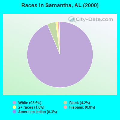
- 3,75693.6%White alone
- 1694.2%Black alone
- 391.0%Two or more races
- 310.8%Hispanic
- 140.3%American Indian alone
- 20.05%Other race alone
- 10.02%Asian alone
 Recent articles from our blog. Our writers, many of them Ph.D. graduates or candidates, create easy-to-read articles on a wide variety of topics.
Current Local Time: CST time zone
Elevation: 390 feet
Land area: 147.9 square miles.
Population density: 29 people per square mile (very low).

| Samantha CCD: | 0.3% ($227) |
| Alabama: | 0.4% ($289) |
Nearest city with pop. 50,000+: Tuscaloosa, AL  (19.1 miles , pop. 77,906).
Nearest city with pop. 200,000+: Birmingham, AL (48.6 miles , pop. 242,820).
Nearest city with pop. 1,000,000+: Houston, TX (522.2 miles , pop. 1,953,631).
Nearest cities:
), ), ), ), ), ), )Latitude: 33.47 N, Longitude: 87.65 W
Area code commonly used in this area: 205

| Here: | 2.3% |
| Alabama: | 2.6% |
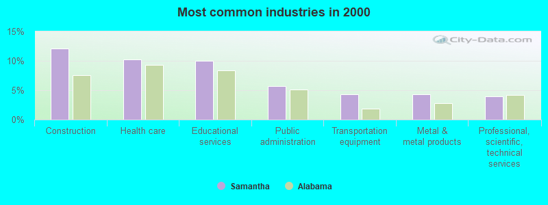
- Construction (12.1%)
- Health care (10.3%)
- Educational services (10.0%)
- Public administration (5.7%)
- Transportation equipment (4.3%)
- Metal & metal products (4.3%)
- Professional, scientific, technical services (3.9%)
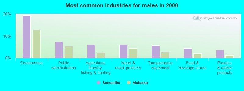
- Construction (19.3%)
- Public administration (7.5%)
- Agriculture, forestry, fishing & hunting (6.0%)
- Metal & metal products (6.0%)
- Transportation equipment (5.7%)
- Food & beverage stores (4.4%)
- Plastics & rubber products (3.8%)
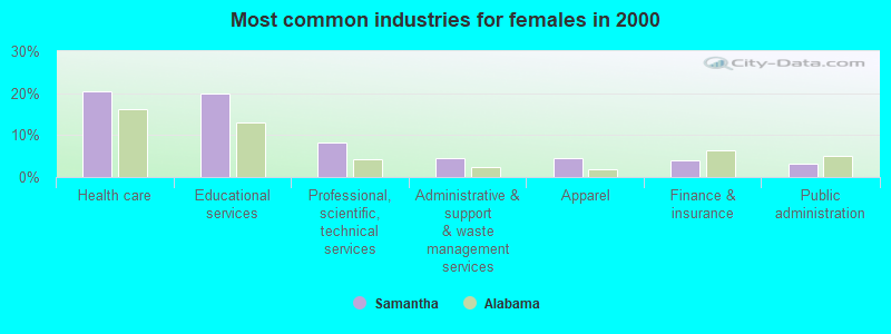
- Health care (20.3%)
- Educational services (19.8%)
- Professional, scientific, technical services (8.2%)
- Administrative & support & waste management services (4.6%)
- Apparel (4.4%)
- Finance & insurance (3.9%)
- Public administration (3.3%)
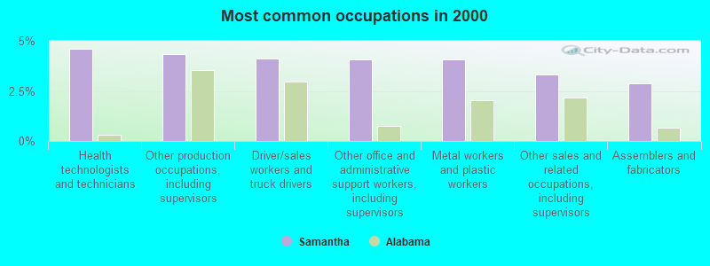
- Health technologists and technicians (4.6%)
- Other production occupations, including supervisors (4.3%)
- Driver/sales workers and truck drivers (4.1%)
- Other office and administrative support workers, including supervisors (4.1%)
- Metal workers and plastic workers (4.1%)
- Other sales and related occupations, including supervisors (3.3%)
- Assemblers and fabricators (2.9%)
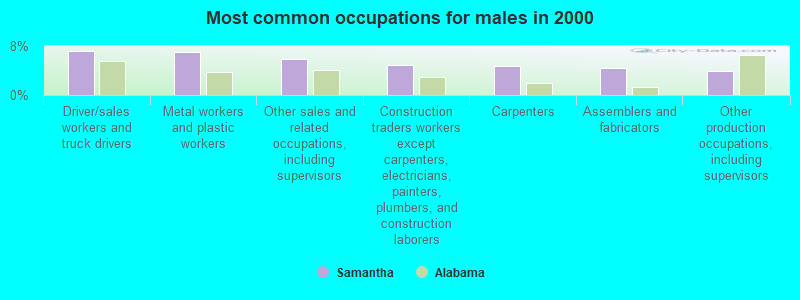
- Driver/sales workers and truck drivers (7.2%)
- Metal workers and plastic workers (7.1%)
- Other sales and related occupations, including supervisors (5.8%)
- Construction traders workers except carpenters, electricians, painters, plumbers, and construction laborers (4.9%)
- Carpenters (4.7%)
- Assemblers and fabricators (4.5%)
- Other production occupations, including supervisors (3.9%)
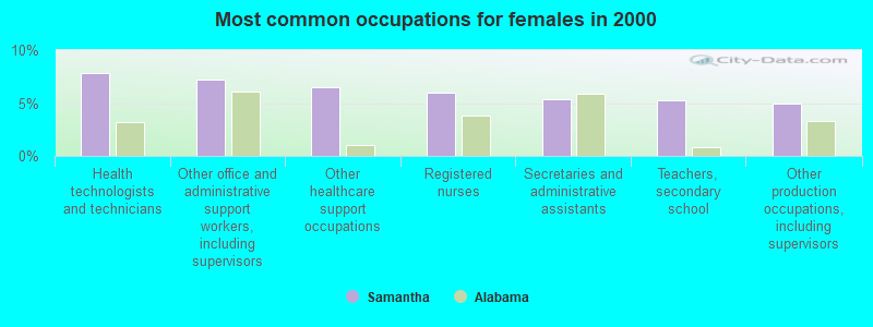
- Health technologists and technicians (7.8%)
- Other office and administrative support workers, including supervisors (7.2%)
- Other healthcare support occupations (6.5%)
- Registered nurses (6.0%)
- Secretaries and administrative assistants (5.3%)
- Teachers, secondary school (5.2%)
- Other production occupations, including supervisors (5.0%)
Average climate in Samantha, Alabama
Based on data reported by over 4,000 weather stations


(lower is better)

Air Quality Index (AQI) level in 2017 was 78.2. This is about average.
| City: | 78.2 |
| U.S.: | 72.6 |
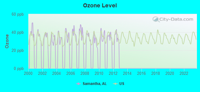
Ozone [ppb] level in 2012 was 35.5. This is about average. Closest monitor was 18.9 miles away from the city center.
| City: | 35.5 |
| U.S.: | 33.3 |
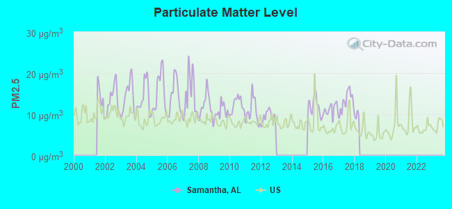
Particulate Matter (PM2.5) [µg/m3] level in 2017 was 13.2. This is significantly worse than average. Closest monitor was 20.0 miles away from the city center.
| City: | 13.2 |
| U.S.: | 8.1 |
Tornado activity:
Samantha-area historical tornado activity is slightly above Alabama state average. It is 127% greater than the overall U.S. average.
On 3/3/1966, a category F5 (max. wind speeds 261-318 mph) tornado 14.9 miles away from the Samantha place center killed 58 people and injured 518 people and caused between $5,000,000 and $50,000,000 in damages.
On 4/8/1998, a category F5 tornado 17.7 miles away from the place center killed 32 people and injured 259 people and caused $200 million in damages.
Earthquake activity:
Samantha-area historical earthquake activity is significantly above Alabama state average. It is 162% greater than the overall U.S. average.On 1/18/1999 at 07:00:53, a magnitude 4.8 (4.8 MB, 4.0 LG, Depth: 0.6 mi, Class: Light, Intensity: IV - V) earthquake occurred 23.3 miles away from the city center
On 6/24/1975 at 11:11:36, a magnitude 4.5 (4.5 MB) earthquake occurred 20.6 miles away from Samantha center
On 4/29/2003 at 08:59:39, a magnitude 4.9 (4.4 MB, 4.6 MW, 4.9 LG) earthquake occurred 136.1 miles away from the city center
On 10/24/1997 at 08:35:17, a magnitude 4.9 (4.8 MB, 4.2 MS, 4.9 LG, Depth: 6.2 mi) earthquake occurred 163.5 miles away from Samantha center
On 11/7/2004 at 11:20:21, a magnitude 4.3 (4.3 MW, Depth: 3.1 mi) earthquake occurred 58.8 miles away from Samantha center
On 3/25/1976 at 00:41:20, a magnitude 5.0 (4.9 MB, 5.0 LG, Class: Moderate, Intensity: VI - VII) earthquake occurred 214.0 miles away from the city center
Magnitude types: regional Lg-wave magnitude (LG), body-wave magnitude (MB), surface-wave magnitude (MS), moment magnitude (MW)
Natural disasters:
The number of natural disasters in Tuscaloosa County (23) is greater than the US average (15).Major Disasters (Presidential) Declared: 16
Emergencies Declared: 5
Causes of natural disasters: Storms: 12, Floods: 10, Tornadoes: 10, Hurricanes: 5, Winds: 4, Drought: 1, Snowfall: 1, Winter Storm: 1, Other: 1 (Note: some incidents may be assigned to more than one category).
Colleges/universities with over 2000 students nearest to Samantha:
- The University of Alabama (about 19 miles; Tuscaloosa, AL; Full-time enrollment: 30,931)
- Shelton State Community College (about 25 miles; Tuscaloosa, AL; FT enrollment: 4,106)
- Bevill State Community College (about 34 miles; Jasper, AL; FT enrollment: 2,970)
- Lawson State Community College-Birmingham Campus (about 44 miles; Birmingham, AL; FT enrollment: 2,695)
- Mississippi University for Women (about 45 miles; Columbus, MS; FT enrollment: 2,565)
- Virginia College-Birmingham (about 49 miles; Birmingham, AL; FT enrollment: 8,167)
- University of Alabama at Birmingham (about 49 miles; Birmingham, AL; FT enrollment: 14,853)
Points of interest:
Notable locations in Samantha: Northside Stadium (A), Tuscaloosa Sailing Club (B), Montgomery Volunteer Fire Department (C), Montgomery Volunteer Fire Department Station 2 (D), Samantha Volunteer Fire Department (E). Display/hide their locations on the map
Churches in Samantha include: Phillips Chapel Freewill Baptist Church (A), Nazareth Primitive Baptist Church (B), Mount Zion Freewill Baptist Church (C), Pole Bridge Church (D), Mount Hebron Baptist Church (E), Macedonia Baptist Church (F), Samantha Church (G), Tabernacle Church (H), Arbor Springs Baptist Church (I). Display/hide their locations on the map
Cemeteries: McGee Cemetery (1), Edmondson Cemetery (2), Old Bethany Cemetery (3), Dawson Cemetery (4), Johnson Cemetery (5), Old Prewitte Cemetery (6), Kemp Cemetery (7). Display/hide their locations on the map
Reservoirs: Mills Lake Lower (A), Pine Lake (B). Display/hide their locations on the map
Streams, rivers, and creeks: Tilly Branch (A), Thomas Mill Branch (B), Spencer Branch (C), Sandy Point Creek (D), Sam Norris Branch (E), Pole Bridge Creek (F), Mud Creek (G), Kates Creek (H), Gin Creek (I). Display/hide their locations on the map
Park in Samantha: Binion Creek Landing Park (1). Display/hide its location on the map
| This place: | 2.7 people |
| Alabama: | 2.5 people |
| This place: | 75.2% |
| Whole state: | 67.8% |
| This place: | 3.8% |
| Whole state: | 4.7% |
Likely homosexual households (counted as self-reported same-sex unmarried-partner households)
- Lesbian couples: 0.4% of all households
- Gay men: 0.2% of all households
| This place: | 13.5% |
| Whole state: | 16.1% |
| This place: | 5.4% |
| Whole state: | 7.3% |
For population 15 years and over in Samantha:
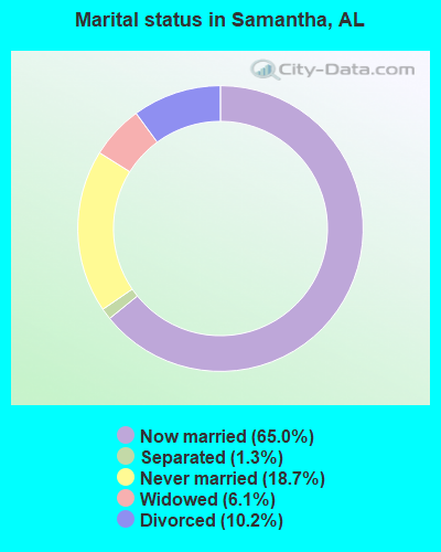
- Never married: 18.7%
- Now married: 65.0%
- Separated: 1.3%
- Widowed: 6.1%
- Divorced: 10.2%
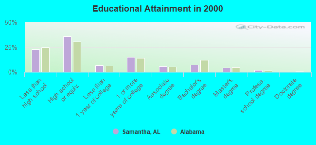
For population 25 years and over in Samantha:
- High school or higher: 77.1%
- Bachelor's degree or higher: 13.2%
- Graduate or professional degree: 5.9%
- Unemployed: 7.2%
- Mean travel time to work (commute): 35.3 minutes
| Here: | 11.2 |
| Alabama average: | 13.2 |
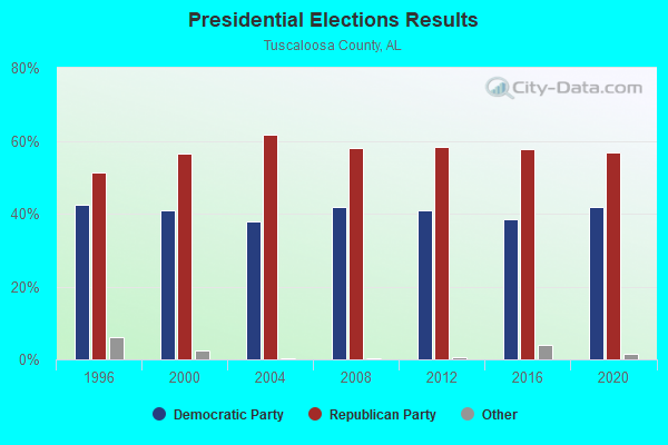
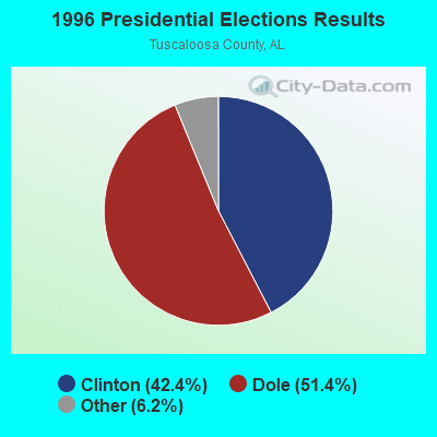
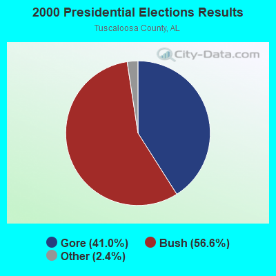
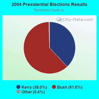
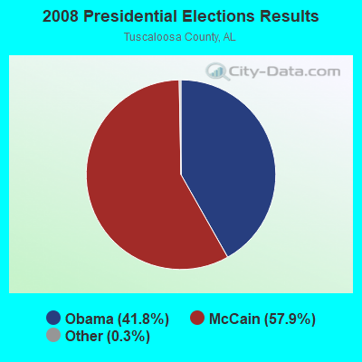
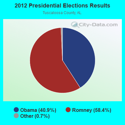
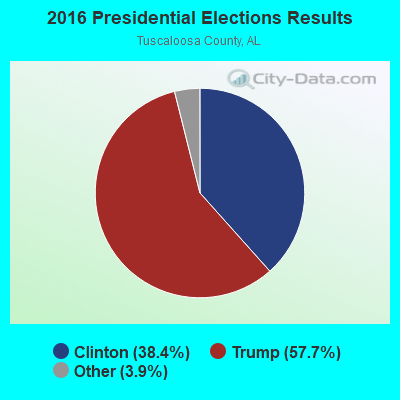
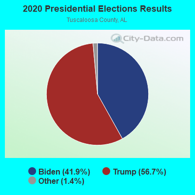
Graphs represent county-level data. Detailed 2008 Election Results
Religion statistics for Samantha, AL (based on Tuscaloosa County data)
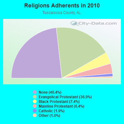
| Religion | Adherents | Congregations |
|---|---|---|
| Evangelical Protestant | 71,803 | 208 |
| Black Protestant | 14,428 | 45 |
| Mainline Protestant | 12,415 | 47 |
| Catholic | 3,729 | 2 |
| Other | 1,940 | 9 |
| None | 90,341 | - |
Food Environment Statistics:
| Here: | 2.03 / 10,000 pop. |
| State: | 1.89 / 10,000 pop. |
| Tuscaloosa County: | 0.23 / 10,000 pop. |
| State: | 0.20 / 10,000 pop. |
| Tuscaloosa County: | 0.56 / 10,000 pop. |
| State: | 0.65 / 10,000 pop. |
| Here: | 5.70 / 10,000 pop. |
| Alabama: | 6.32 / 10,000 pop. |
| This county: | 5.47 / 10,000 pop. |
| Alabama: | 5.75 / 10,000 pop. |
| Tuscaloosa County: | 10.7% |
| Alabama: | 11.8% |
| Tuscaloosa County: | 32.2% |
| Alabama: | 31.7% |
| This county: | 10.8% |
| Alabama: | 13.5% |
Strongest AM radio stations in Samantha:
- WJOX (690 AM; 50 kW; BIRMINGHAM, AL; Owner: CITADEL BROADCASTING COMPANY)
- WAPI (1070 AM; 50 kW; BIRMINGHAM, AL; Owner: CITADEL BROADCASTING COMPANY)
- WDJC (850 AM; 50 kW; BIRMINGHAM, AL; Owner: KIMTRON, INC.)
- WSPZ (1150 AM; 5 kW; TUSCALOOSA, AL; Owner: RADIO SOUTH, INC)
- WTSK (790 AM; 5 kW; TUSCALOOSA, AL; Owner: APEX BROADCASTING INC.)
- WWPG (1280 AM; 5 kW; TUSCALOOSA, AL; Owner: LAWSON OF TUSCALOOSA, INC.)
- WACT (1420 AM; 5 kW; TUSCALOOSA, AL; Owner: CAPSTAR TX LIMITED PARTNERSHIP)
- WCPC (940 AM; 50 kW; HOUSTON, MS; Owner: WCPC BROADCASTING CO., INC.)
- WNSI (810 AM; 50 kW; JACKSONVILLE, AL; Owner: UNITED BROADCASTING NETWORK, INC.)
- WKXM (1300 AM; 5 kW; WINFIELD, AL; Owner: AD-MEDIA MANAGEMENT CORP.)
- WCOC (1010 AM; 5 kW; DORA, AL; Owner: AZTECA COMMUNICATIONS OF ALABAMA, INC.)
- WLDX (990 AM; 1 kW; FAYETTE, AL; Owner: THOMLEY BROADCASTING CO., INC.)
- WVSA (1380 AM; 5 kW; VERNON, AL; Owner: LAMAR CTY. B/CING. CO., INC.)
Strongest FM radio stations in Samantha:
- WDXB (102.5 FM; JASPER, AL; Owner: CAPSTAR TX LIMITED PARTNERSHIP)
- WTXT (98.1 FM; FAYETTE, AL; Owner: CAPSTAR TX LIMITED PARTNERSHIP)
- WBEI (101.7 FM; REFORM, AL; Owner: APEX BROADCASTING INC.)
- WBHJ (95.7 FM; TUSCALOOSA, AL; Owner: CXR HOLDINGS, INC.)
- WTUG-FM (92.9 FM; TUSCALOOSA, AL; Owner: APEX BROADCASTING INC.)
- WZBQ (94.1 FM; CARROLLTON, AL; Owner: CAPSTAR TX LIMITED PARTNERSHIP)
- WANZ (100.7 FM; NORTHPORT, AL; Owner: APEX BRAODCASTING INC.)
- WODL (97.3 FM; HOMEWOOD, AL; Owner: CXR HOLDINGS, INC.)
- WBHK (98.7 FM; WARRIOR, AL; Owner: CXR HOLDINGS, INC.)
- WZZK-FM (104.7 FM; BIRMINGHAM, AL; Owner: CXR HOLDINGS, INC.)
- WBPT (106.9 FM; BIRMINGHAM, AL; Owner: CXR HOLDINGS, INC.)
- WYSF (94.5 FM; BIRMINGHAM, AL; Owner: CITADEL BROADCASTING COMPANY)
- WMJJ (96.5 FM; BIRMINGHAM, AL; Owner: CAPSTAR TX LIMITED PARTNERSHIP)
- WALN (89.3 FM; CARROLLTON, AL; Owner: AMERICAN FAMILY ASSOCIATION)
- WQEN (103.7 FM; GADSDEN, AL; Owner: CAPSTAR TX LIMITED PARTNERSHIP)
- WBHM (90.3 FM; BIRMINGHAM, AL; Owner: BD OF TRUSTEES/U OF AL AT BIRMINGHAM)
- WZRR (99.5 FM; BIRMINGHAM, AL; Owner: CITADEL BROADCASTING COMPANY)
- WDJC-FM (93.7 FM; BIRMINGHAM, AL; Owner: KIMTRON, INC.)
- WRTR (105.5 FM; TUSCALOOSA, AL; Owner: CAPSTAR TX LIMITED PARTNERSHIP)
- WUAL-FM (91.5 FM; TUSCALOOSA, AL; Owner: UNIVERSITY OF ALABAMA)
TV broadcast stations around Samantha:
- WCFT-TV (Channel 33; TUSCALOOSA, AL; Owner: TV ALABAMA, INCORPORATED)
- WDBB (Channel 17; BESSEMER, AL; Owner: WDBB-TV, INC.)
- WVUA-CA (Channel 7; TUSCALOOSA/NORTHPORT, AL; Owner: THE BOARD OF TRUSTEES OF THE UNIVERSITY OF ALABAMA)
- WLDM (Channel 23; TUSCALOOSA, AL; Owner: CHANNEL 23, LLC)
- W46BU (Channel 46; TUSCALOOSA, AL; Owner: TRINITY BROADCASTING NETWORK)
- WSFG-LP (Channel 63; BERRY, AL; Owner: ETTIE CLARK)
- WSSF-LP (Channel 58; BERRY, AL; Owner: ETTIE CLARK)
FCC Registered Cell Phone Towers:
1 (See the full list of FCC Registered Cell Phone Towers in Samantha)FCC Registered Antenna Towers:
7 (See the full list of FCC Registered Antenna Towers)FCC Registered Microwave Towers:
1- SAMANTHA, N Of Samantha E Of Hwy 43 (Lat: 33.424556 Lon: -87.601944), Overall height: 90.8 m, Call Sign: WML950,
Assigned Frequencies: 2118.40 MHz, Grant Date: 12/19/2000, Expiration Date: 02/01/2011, Cancellation Date: 01/15/2009, Registrant: Verizon Wireless, 1120 Sanctuary Pkwy, #150, Gasa5reg, Alpharetta, GA 30004, Phone: (770) 797-1070, Fax: (770) 797-1036, Email:
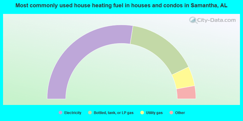
- 55.0%Electricity
- 30.9%Bottled, tank, or LP gas
- 8.5%Utility gas
- 3.1%Wood
- 1.7%Coal or coke
- 0.9%Other fuel
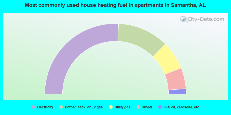
- 51.4%Electricity
- 23.5%Bottled, tank, or LP gas
- 13.0%Utility gas
- 9.7%Wood
- 2.4%Fuel oil, kerosene, etc.
Samantha compared to Alabama state average:
- Unemployed percentage below state average.
- Black race population percentage significantly below state average.
- Hispanic race population percentage significantly below state average.
- Median age significantly below state average.
- Foreign-born population percentage significantly below state average.
- Renting percentage below state average.
- Length of stay since moving in significantly above state average.
- Number of rooms per house significantly below state average.
- House age significantly below state average.
Samantha on our top lists:
- #44 on the list of "Top 101 larger cities with the lowest real estate taxes percentage (population 50,000+)"
- #15 on the list of "Top 101 counties with the lowest Ozone (1-hour) air pollution readings in 2012 (ppm)"
- #16 on the list of "Top 101 counties with the worst general health status score of residents (1-5), 3 years of data"
- #18 on the list of "Top 101 counties with the lowest percentage of residents that visited a dentist within the past year"
- #23 on the list of "Top 101 counties with the lowest percentage of residents relocating from foreign countries between 2010 and 2011"
- #29 on the list of "Top 101 counties with the lowest percentage of residents that smoked 100+ cigarettes in their lives"