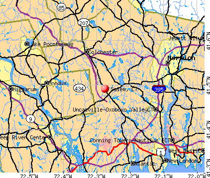
Salem, Connecticut
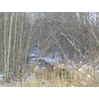
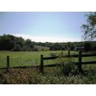
Salem: Salem Landscapes
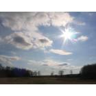
Salem: Salem Skies
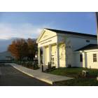
Salem: New Salem Free Public Library

Salem: A vibrant sunset in Salem, CT
Salem: Salem Landscape - Town Green
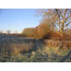
Salem: Bingham's Field
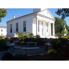
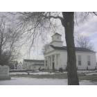
Salem: Congregational Church, Salem, CT
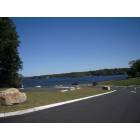
Salem: Gardner Lake, Salem, CT
Salem: Red barn in the distance
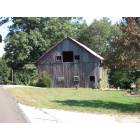
Salem: Grey Barn on local road in Salem, CT
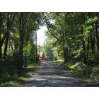
Salem: Summer in Salem, CT
- see
15
more - add
your


Submit your own pictures of this town and show them to the world
- OSM Map
- General Map
- Google Map
- MSN Map
Population change since 2000: +7.6%
 |
| Males: 2,097 | |
| Females: 2,054 |
| Median resident age: | 41.8 years |
| Connecticut median age: | 39.2 years |
Zip codes: 06420.
| Salem: | $112,719 |
| CT: | $88,429 |
Estimated per capita income in 2022: $48,931 (it was $27,288 in 2000)
Salem town income, earnings, and wages data
Estimated median house or condo value in 2022: $386,114 (it was $178,600 in 2000)
| Salem: | $386,114 |
| CT: | $347,200 |
Mean prices in 2022: all housing units: $336,024; detached houses: $358,368; townhouses or other attached units: $232,367; in 2-unit structures: $294,123; in 3-to-4-unit structures: $234,423; in 5-or-more-unit structures: $212,293; mobile homes: $38,564; occupied boats, rvs, vans, etc.: $86,722
Detailed information about poverty and poor residents in Salem, CT


- 3,76490.7%White alone
- 1293.1%Asian alone
- 1052.5%Hispanic
- 761.8%Two or more races
- 581.4%Black alone
- 100.2%American Indian alone
- 50.1%Native Hawaiian and Other
Pacific Islander alone - 40.10%Other race alone
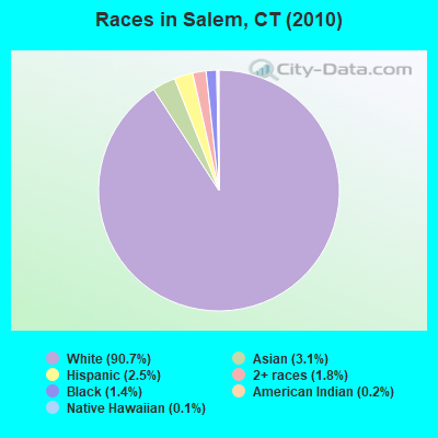
Races in Salem detailed stats: ancestries, foreign born residents, place of birth
According to our research of Connecticut and other state lists, there were 4 registered sex offenders living in Salem, Connecticut as of May 08, 2024.
The ratio of all residents to sex offenders in Salem is 1,038 to 1.
The ratio of registered sex offenders to all residents in this city is lower than the state average.
 Recent articles from our blog. Our writers, many of them Ph.D. graduates or candidates, create easy-to-read articles on a wide variety of topics.


 | 2024 Connecticut Town Tournament VI (Celebrating the 10-Year Anniversary & Dazzleman's Memorial) (830 replies) |
| listing of summer must hit ice cream spots (45 replies) |
| Connecticut TOWN TOURNAMENT V (2022) (831 replies) |
| Favorite Ice Cream in Connecticut (71 replies) |
| CT Elections 2021 results (71 replies) |
| Best Ice Cream in Connecticut? (43 replies) |
Latest news from Salem, CT collected exclusively by city-data.com from local newspapers, TV, and radio stations
Salem, CT City Guides:
Ancestries: Irish (24.4%), English (20.4%), German (17.1%), Italian (14.1%), Polish (11.3%), French (7.0%).
Current Local Time: EST time zone
Incorporated on 05/05/1819
Elevation: 362 feet
Land area: 29.0 square miles.
Population density: 143 people per square mile (very low).
125 residents are foreign born (1.8% Europe, 0.9% Asia, 0.4% Latin America).
| This town: | 3.2% |
| Connecticut: | 10.9% |
| Salem town: | 1.7% ($3,026) |
| Connecticut: | 1.8% ($2,961) |
Nearest city with pop. 50,000+: Manchester, CT  (24.6 miles , pop. 54,740).
Nearest city with pop. 200,000+: Boston, MA (83.3 miles , pop. 589,141).
Nearest city with pop. 1,000,000+: Bronx, NY (95.2 miles , pop. 1,332,650).
Nearest cities:
), ), ), ), Latitude: 41.49 N, Longitude: 72.25 W
Area code commonly used in this area: 860

Single-family new house construction building permits:
- 2022: 9 buildings, average cost: $341,300
- 2021: 51 buildings, average cost: $113,200
- 2020: 8 buildings, average cost: $332,000
- 2019: 11 buildings, average cost: $333,100
- 2018: 4 buildings, average cost: $233,800
- 2017: 9 buildings, average cost: $309,500
- 2016: 9 buildings, average cost: $216,900
- 2015: 9 buildings, average cost: $376,500
- 2014: 16 buildings, average cost: $295,400
- 2013: 3 buildings, average cost: $310,400
- 2012: 6 buildings, average cost: $250,300
- 2011: 7 buildings, average cost: $251,700
- 2010: 11 buildings, average cost: $340,000
- 2009: 9 buildings, average cost: $316,300
- 2008: 9 buildings, average cost: $356,500
- 2007: 11 buildings, average cost: $315,800
- 2006: 13 buildings, average cost: $320,900
- 2005: 28 buildings, average cost: $229,400
- 2004: 34 buildings, average cost: $247,800
- 2003: 26 buildings, average cost: $251,300
- 2002: 34 buildings, average cost: $200,100
- 2001: 23 buildings, average cost: $225,400
- 2000: 18 buildings, average cost: $141,600
- 1999: 17 buildings, average cost: $164,500
- 1998: 24 buildings, average cost: $153,500
- 1997: 14 buildings, average cost: $140,500
| Here: | 3.7% |
| Connecticut: | 3.9% |

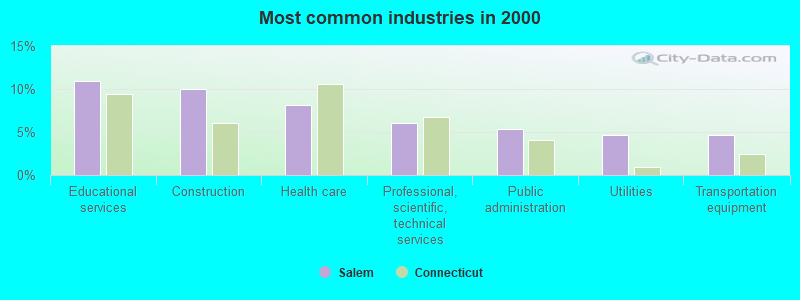
- Educational services (10.9%)
- Construction (10.0%)
- Health care (8.1%)
- Professional, scientific, technical services (6.1%)
- Public administration (5.3%)
- Utilities (4.7%)
- Transportation equipment (4.6%)
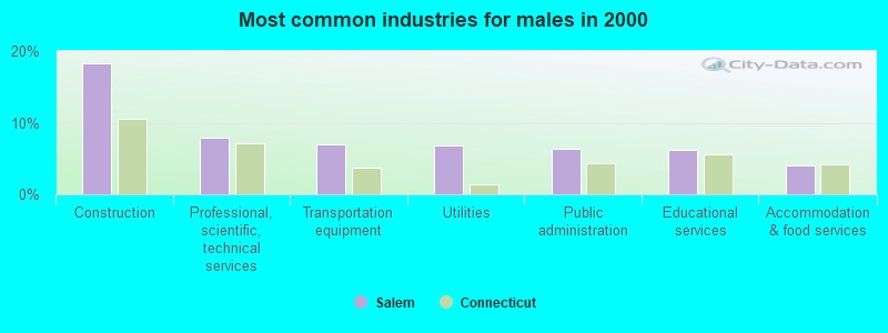
- Construction (18.3%)
- Professional, scientific, technical services (8.0%)
- Transportation equipment (6.9%)
- Utilities (6.8%)
- Public administration (6.3%)
- Educational services (6.1%)
- Accommodation & food services (4.0%)
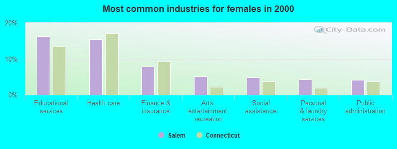
- Educational services (16.3%)
- Health care (15.4%)
- Finance & insurance (7.9%)
- Arts, entertainment, recreation (5.0%)
- Social assistance (4.8%)
- Personal & laundry services (4.2%)
- Public administration (4.2%)
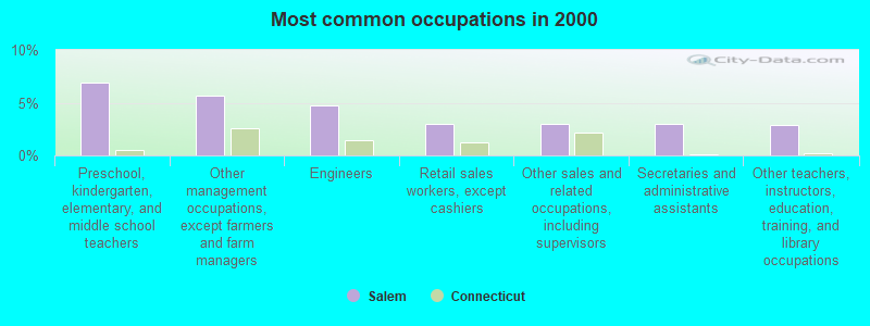
- Preschool, kindergarten, elementary, and middle school teachers (6.9%)
- Other management occupations, except farmers and farm managers (5.7%)
- Engineers (4.7%)
- Retail sales workers, except cashiers (3.0%)
- Other sales and related occupations, including supervisors (3.0%)
- Secretaries and administrative assistants (3.0%)
- Other teachers, instructors, education, training, and library occupations (2.9%)
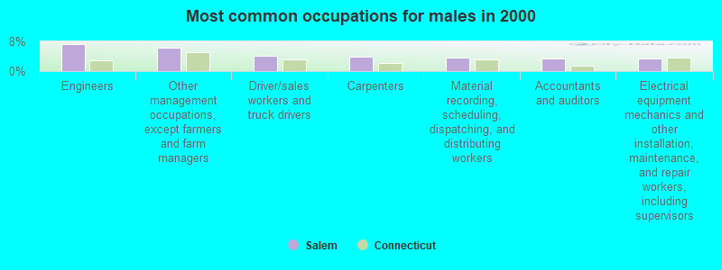
- Engineers (7.2%)
- Other management occupations, except farmers and farm managers (6.4%)
- Driver/sales workers and truck drivers (4.0%)
- Carpenters (3.8%)
- Material recording, scheduling, dispatching, and distributing workers (3.6%)
- Accountants and auditors (3.5%)
- Electrical equipment mechanics and other installation, maintenance, and repair workers, including supervisors (3.4%)
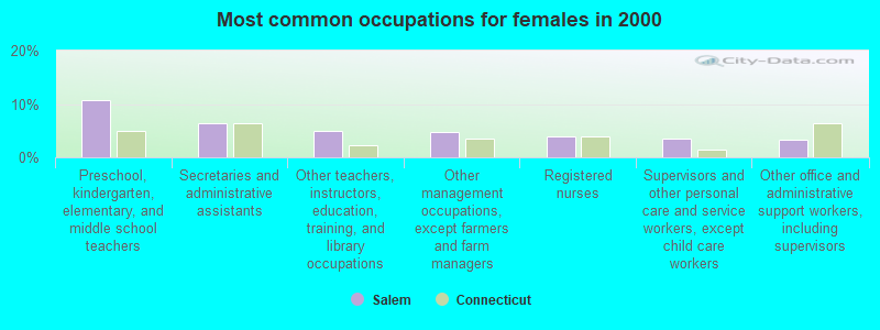
- Preschool, kindergarten, elementary, and middle school teachers (10.8%)
- Secretaries and administrative assistants (6.3%)
- Other teachers, instructors, education, training, and library occupations (4.9%)
- Other management occupations, except farmers and farm managers (4.8%)
- Registered nurses (3.9%)
- Supervisors and other personal care and service workers, except child care workers (3.5%)
- Other office and administrative support workers, including supervisors (3.4%)
Average climate in Salem, Connecticut
Based on data reported by over 4,000 weather stations


(lower is better)
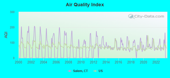
Air Quality Index (AQI) level in 2022 was 72.1. This is about average.
| City: | 72.1 |
| U.S.: | 72.6 |
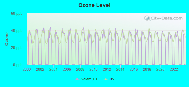
Ozone [ppb] level in 2022 was 33.8. This is about average. Closest monitor was 12.7 miles away from the city center.
| City: | 33.8 |
| U.S.: | 33.3 |
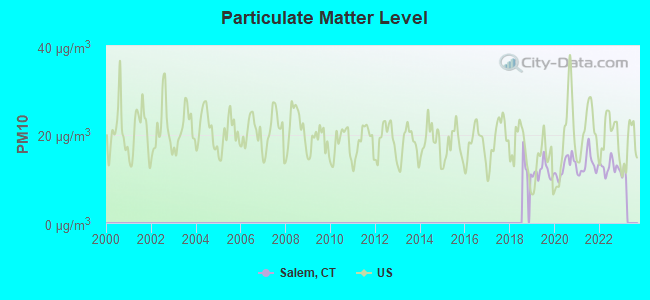
Particulate Matter (PM10) [µg/m3] level in 2022 was 12.6. This is significantly better than average. Closest monitor was 9.6 miles away from the city center.
| City: | 12.6 |
| U.S.: | 19.2 |
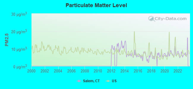
Particulate Matter (PM2.5) [µg/m3] level in 2022 was 6.58. This is better than average. Closest monitor was 9.6 miles away from the city center.
| City: | 6.58 |
| U.S.: | 8.11 |
Tornado activity:
Salem-area historical tornado activity is slightly below Connecticut state average. It is 41% smaller than the overall U.S. average.
On 7/10/1989, a category F4 (max. wind speeds 207-260 mph) tornado 34.3 miles away from the Salem town center injured 40 people and caused between $50,000,000 and $500,000,000 in damages.
On 10/3/1979, a category F4 tornado 34.7 miles away from the town center killed 3 people and injured 500 people and caused between $50,000,000 and $500,000,000 in damages.
Earthquake activity:
Salem-area historical earthquake activity is significantly above Connecticut state average. It is 72% smaller than the overall U.S. average.On 10/7/1983 at 10:18:46, a magnitude 5.3 (5.1 MB, 5.3 LG, 5.1 ML, Class: Moderate, Intensity: VI - VII) earthquake occurred 200.9 miles away from the city center
On 4/20/2002 at 10:50:47, a magnitude 5.3 (5.3 ML, Depth: 3.0 mi) earthquake occurred 221.7 miles away from Salem center
On 4/20/2002 at 10:50:47, a magnitude 5.2 (5.2 MB, 4.2 MS, 5.2 MW, 5.0 MW) earthquake occurred 220.4 miles away from Salem center
On 1/19/1982 at 00:14:42, a magnitude 4.7 (4.5 MB, 4.7 MD, 4.5 LG, Class: Light, Intensity: IV - V) earthquake occurred 143.3 miles away from the city center
On 10/16/2012 at 23:12:25, a magnitude 4.7 (4.7 ML, Depth: 10.0 mi) earthquake occurred 167.2 miles away from the city center
On 8/22/1992 at 12:20:32, a magnitude 4.8 (4.8 MB, 3.8 MS, 4.7 LG, Depth: 6.2 mi) earthquake occurred 193.7 miles away from the city center
Magnitude types: regional Lg-wave magnitude (LG), body-wave magnitude (MB), duration magnitude (MD), local magnitude (ML), surface-wave magnitude (MS), moment magnitude (MW)
Natural disasters:
The number of natural disasters in New London County (22) is greater than the US average (15).Major Disasters (Presidential) Declared: 12
Emergencies Declared: 10
Causes of natural disasters: Hurricanes: 6, Snowstorms: 5, Storms: 5, Floods: 4, Blizzards: 3, Winter Storms: 3, Snows: 2, Snowfall: 1, Tropical Storm: 1, Wind: 1 (Note: some incidents may be assigned to more than one category).
Hospitals and medical centers near Salem:
- AURORA SENIOR LIVING OF CROMWELL, LLC (Nursing Home, about 8 miles away; CROMWELL, CT)
- CROMWELL CREST REST HOME (Nursing Home, about 8 miles away; CROMWELL, CT)
- ORCHARD GROVE SPECIALTY CARE CENTER, LLC (Nursing Home, about 8 miles away; UNCASVILLE, CT)
- HARRINGTON COURT (Nursing Home, about 8 miles away; COLCHESTER, CT)
- APPLE REHAB COLCHESTER (Nursing Home, about 8 miles away; COLCHESTER, CT)
- NORWICH DIALYSIS (Dialysis Facility, about 8 miles away; NORWICH, CT)
- GREENTREE MANOR NURSING AND REHA (Nursing Home, about 9 miles away; WATERFORD, CT)
Amtrak stations near Salem:
- 13 miles: NEW LONDON (27 WATER ST.) . Services: ticket office, partially wheelchair accessible, enclosed waiting area, public restrooms, public payphones, paid short-term parking, paid long-term parking, call for car rental service, taxi stand, intercity bus service, public transit connection.
- 15 miles: OLD SAYBROOK (455 BOSTON POST RD.) . Services: ticket office, partially wheelchair accessible, enclosed waiting area, public restrooms, public payphones, free short-term parking, free long-term parking, call for car rental service, call for taxi service, public transit connection.
- 15 miles: FOXWOOD CASINO (LEDYARD, ROUTE 2) - Bus Station
Operable nuclear power plants near Salem:
- 11 miles: Millstone 1 and 2 in Waterford, CT.
- 11 miles: Millstone 3 in Waterford, CT.
Colleges/universities with over 2000 students nearest to Salem:
- Three Rivers Community College (about 9 miles; Norwich, CT; Full-time enrollment: 2,897)
- Connecticut College (about 11 miles; New London, CT; FT enrollment: 2,068)
- Eastern Connecticut State University (about 17 miles; Willimantic, CT; FT enrollment: 4,985)
- Wesleyan University (about 22 miles; Middletown, CT; FT enrollment: 3,517)
- University of Connecticut (about 23 miles; Storrs, CT; FT enrollment: 22,037)
- Manchester Community College (about 25 miles; Manchester, CT; FT enrollment: 4,667)
- Goodwin College (about 27 miles; East Hartford, CT; FT enrollment: 3,017)
Public elementary/middle school in Salem:
- SALEM ELEMENTARY SCHOOL (Students: 545, Location: 200 HARTFORD ROAD, Grades: PK-8)
User-submitted facts and corrections:
- Salem is a horrible place to build. Internet(high speed or not) is unreliable here. Residents are over taxed and yet the town provides no social functions or anything with all the tax money they get. They give residents & business hard times about making their businesses look better. The town assessors office also likes to over appraise property and taxable content quite a bit. Electric costs are very high here as well.
added by Wolferider
- Birthplace of college basketball player Whitney Coleman (Monmouth University, NJ)
Points of interest:
Notable locations in Salem: Salem Four Corners (A), The Wales (B), Camp Winnapaw (C), Camp Wetonaw (D), Camp Trupin (E), Square Ranch (F), Camp Wakenah (G), Camp Winnepaw (H), Salem Volunteer Fire Company (I), Salem Town Hall (J), Salem Historical Society Building (K), Gardner Lake Volunteer Fire Company Station 27 (L). Display/hide their locations on the map
Churches in Salem include: Salem Congregational Church (A), Paugwaunk Church (B). Display/hide their locations on the map
Cemeteries: Lathrop Cemetery (1), Salem Cemetery (2), Fox Cemetery (3), Congregational Church of Salem Cemetery (4), Cockle Hill Cemetery (5), Winaker Cemetery (6), Woodbridge Cemetery (7). Display/hide their locations on the map
Lakes, reservoirs, and swamps: Fairy Lake (A), Gardner Lake (B), Horse Pond (C), Mill Pond (D), Mitchell Pond (E), Shingle Mill Pond (F), Barnes Reservoir (G), Plants Pond (H). Display/hide their locations on the map
Streams, rivers, and creeks: Shingle Mill Brook (A), Witch Meadow Brook (B), Big Brook (C), Fraser Brook (D), Harris Brook (E), Sucker Brook (F). Display/hide their locations on the map
Parks in Salem include: Minnie Island State Park (1), Gardner Lake Park (2). Display/hide their locations on the map
Drinking water stations with addresses in Salem and their reported violations in the past:
CEDAR RIDGE APARTMENTS (Population served: 300, Groundwater):Past monitoring violations:CARRIAGE HOUSE APARTMENTS (Population served: 196, Groundwater):
- One routine major monitoring violation
- 99 regular monitoring violations
Past health violations:WITCH MEADOW LAKE CAMPGROUND - WELL #2 (Population served: 25, Groundwater):Past monitoring violations:
- MCL, Monthly (TCR) - In SEP-2012, Contaminant: Coliform. Follow-up actions: St Public Notif received (OCT-09-2012), St Public Notif requested (OCT-12-2012), St Violation/Reminder Notice (OCT-12-2012), St Compliance achieved (OCT-31-2012)
- MCL, Monthly (TCR) - In OCT-2005, Contaminant: Coliform. Follow-up actions: St Public Notif requested (NOV-08-2005), St Violation/Reminder Notice (NOV-08-2005), St AO (w/penalty) issued (NOV-17-2005), St Public Notif received (NOV-21-2005), St Compliance achieved (JUN-30-2006)
- MCL, Acute (TCR) - In OCT-2005, Contaminant: Coliform. Follow-up actions: St Public Notif requested (NOV-08-2005), St Violation/Reminder Notice (NOV-08-2005), St AO (w/penalty) issued (NOV-17-2005), St Public Notif received (NOV-21-2005), St Compliance achieved (JUN-30-2006)
- MCL, Monthly (TCR) - In MAY-2005, Contaminant: Coliform. Follow-up actions: St Public Notif requested (JUN-06-2005), St Violation/Reminder Notice (JUN-06-2005), St AO (w/penalty) issued (NOV-17-2005), St Compliance achieved (JUN-30-2006)
- Follow-up Or Routine LCR Tap M/R - In JAN-10-2005, Contaminant: Lead and Copper Rule. Follow-up actions: St AO (w/penalty) issued (JUN-30-2005), St Compliance achieved (DEC-30-2005)
Past monitoring violations:
- One routine major monitoring violation
Drinking water stations with addresses in Salem that have no violations reported:
- WITCH MEADOW LAKE CAMPGROUND - WELL #1 (Population served: 50, Primary Water Source Type: Groundwater)
- WITCH MEADOW LAKE CAMPGROUND - WELL #3 (Population served: 25, Primary Water Source Type: Groundwater)
| This town: | 2.7 people |
| Connecticut: | 2.5 people |
| This town: | 76.8% |
| Whole state: | 66.3% |
| This town: | 6.1% |
| Whole state: | 6.6% |
Likely homosexual households (counted as self-reported same-sex unmarried-partner households)
- Lesbian couples: 0.4% of all households
- Gay men: 0.3% of all households
| This town: | 1.0% |
| Whole state: | 7.9% |
| This town: | 0.3% |
| Whole state: | 3.9% |
8 people in homes for the mentally retarded in 2000
Banks with branches in Salem (2011 data):
- Chelsea Groton Bank: Salem Branch at 2 Salem Marketplace Routes 82 & 85, branch established on 1987/05/18. Info updated 2010/06/21: Bank assets: $836.6 mil, Deposits: $688.4 mil, headquarters in Norwich, CT, positive income, Mortgage Lending Specialization, 14 total offices
For population 15 years and over in Salem:
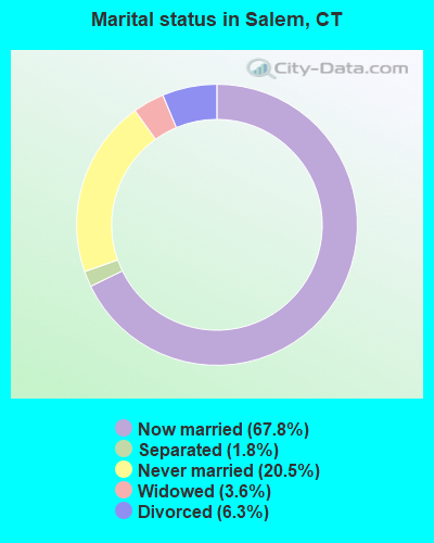
- Never married: 20.5%
- Now married: 67.8%
- Separated: 1.8%
- Widowed: 3.6%
- Divorced: 6.3%
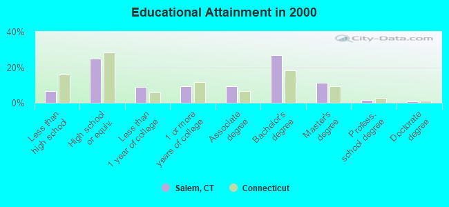
For population 25 years and over in Salem:
- High school or higher: 93.5%
- Bachelor's degree or higher: 40.7%
- Graduate or professional degree: 13.9%
- Unemployed: 1.8%
- Mean travel time to work (commute): 26.5 minutes
| Here: | 10.1 |
| Connecticut average: | 12.8 |
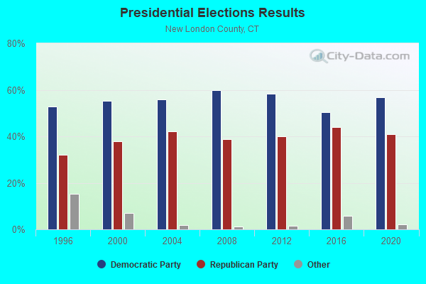
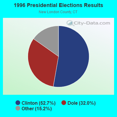
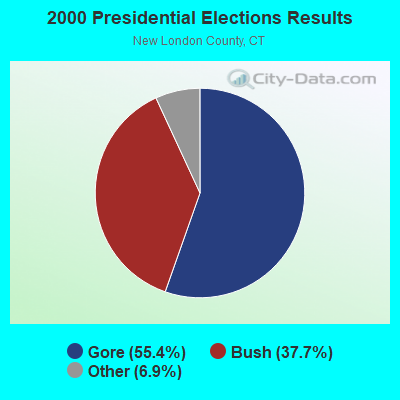

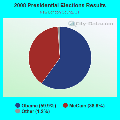

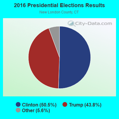
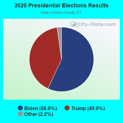
Graphs represent county-level data. Detailed 2008 Election Results
Religion statistics for Salem, CT (based on New London County data)
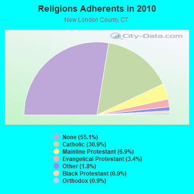
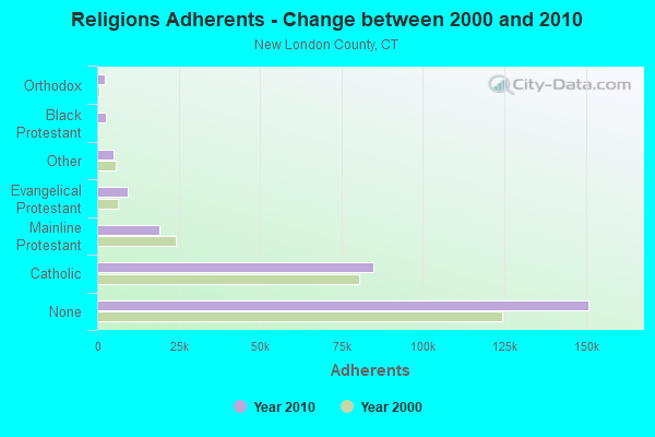
| Religion | Adherents | Congregations |
|---|---|---|
| Catholic | 84,765 | 34 |
| Mainline Protestant | 18,993 | 79 |
| Evangelical Protestant | 9,320 | 75 |
| Other | 5,022 | 32 |
| Black Protestant | 2,594 | 10 |
| Orthodox | 2,456 | 4 |
| None | 150,905 | - |
Food Environment Statistics:
| This county: | 1.82 / 10,000 pop. |
| State: | 2.21 / 10,000 pop. |
| This county: | 0.11 / 10,000 pop. |
| Connecticut: | 0.07 / 10,000 pop. |
| This county: | 1.36 / 10,000 pop. |
| Connecticut: | 1.02 / 10,000 pop. |
| This county: | 3.22 / 10,000 pop. |
| Connecticut: | 2.27 / 10,000 pop. |
| Here: | 10.01 / 10,000 pop. |
| State: | 9.19 / 10,000 pop. |
| Here: | 7.6% |
| State: | 7.3% |
| Here: | 22.4% |
| Connecticut: | 21.5% |
| This county: | 16.5% |
| Connecticut: | 15.8% |
6.16% of this county's 2021 resident taxpayers lived in other counties in 2020 ($81,025 average adjusted gross income)
| Here: | 6.16% |
| Connecticut average: | 5.79% |
0.04% of residents moved from foreign countries ($359 average AGI)
New London County: 0.04% Connecticut average: 0.02%
Top counties from which taxpayers relocated into this county between 2020 and 2021:
| from Hartford County, CT | |
| from Windham County, CT | |
| from Middlesex County, CT |
6.02% of this county's 2020 resident taxpayers moved to other counties in 2021 ($71,482 average adjusted gross income)
| Here: | 6.02% |
| Connecticut average: | 5.82% |
0.05% of residents moved to foreign countries ($502 average AGI)
New London County: 0.05% Connecticut average: 0.02%
Top counties to which taxpayers relocated from this county between 2020 and 2021:
| to Hartford County, CT | |
| to Windham County, CT | |
| to Middlesex County, CT |
Businesses in Salem, CT
- Subway: 1
- U-Haul: 1
Strongest AM radio stations in Salem:
- WTIC (1080 AM; 50 kW; HARTFORD, CT; Owner: INFINITY RADIO OPERATIONS INC.)
- WICH (1310 AM; 5 kW; NORWICH, CT; Owner: WICH, INCORPORATED)
- WNNZ (640 AM; 50 kW; WESTFIELD, MA; Owner: CLEAR CHANNEL BROADCASTING LICENSES, INC.)
- WALE (990 AM; 50 kW; GREENVILLE, RI; Owner: NORTH AMERICAN BROADCASTING CO., INC.)
- WLIS (1420 AM; 5 kW; OLD SAYBROOK, CT; Owner: CROSSROADS COMM. OLD SAYBROOK, LLC)
- WCRN (830 AM; 50 kW; WORCESTER, MA; Owner: CARTER BROADCASTING CORPORATION)
- WVNE (760 AM; daytime; 25 kW; LEICESTER, MA; Owner: BLOUNT MASSCOM, INC.)
- WEEI (850 AM; 50 kW; BOSTON, MA; Owner: ENTERCOM BOSTON LICENSE, LLC)
- WRKO (680 AM; 50 kW; BOSTON, MA; Owner: ENTERCOM BOSTON LICENSE, LLC)
- WFAN (660 AM; 50 kW; NEW YORK, NY; Owner: INFINITY BROADCASTING OPERATIONS, INC.)
- WKOX (1200 AM; 50 kW; FRAMINGHAM, MA; Owner: CAPSTAR TX LIMITED PARTNERSHIP)
- WBIX (1060 AM; 40 kW; NATICK, MA; Owner: LANGER BROADCASTING CORPORATION)
- WSUB (980 AM; 1 kW; GROTON, CT; Owner: CITADEL BROADCASTING COMPANY)
Strongest FM radio stations in Salem:
- WKNL (100.9 FM; NEW LONDON, CT; Owner: HALL COMMUNICATIONS, INC.)
- WCTY (97.7 FM; NORWICH, CT; Owner: WICH, INC.)
- WBMW (106.5 FM; LEDYARD, CT; Owner: RED WOLF BROADCASTING CORPORATION)
- WILI-FM (98.3 FM; WILLIMANTIC, CT; Owner: NUTMEG BROADCASTING COMPANY)
- WRCH (100.5 FM; NEW BRITAIN, CT; Owner: INFINITY RADIO OPERATIONS INC.)
- WECS (90.1 FM; WILLIMANTIC, CT; Owner: EASTERN CONNECTICUT STATE COLLEGE)
- WHJM (107.7 FM; PAWCATUCK, CT; Owner: FULLER BROADCASTING INTERNATIONAL, LLC)
- WQGN-FM (105.5 FM; GROTON, CT; Owner: CITADEL BROADCASTING COMPANY)
- WNLC (98.7 FM; EAST LYME, CT; Owner: HALL COMMUNICATIONS, INC.)
- WKSS (95.7 FM; HARTFORD-MERIDEN, CT; Owner: CAPSTAR TX LIMITED PARTNERSHIP)
- WWYZ (92.5 FM; WATERBURY, CT; Owner: CAPSTAR TX LIMITED PARTNERSHIP)
- WKCI-FM (101.3 FM; HAMDEN, CT; Owner: CLEAR CHANNEL BROADCASTING LICENSES, INC.)
- WZMX (93.7 FM; HARTFORD, CT; Owner: INFINITY RADIO OPERATIONS INC.)
- WHCN (105.9 FM; HARTFORD, CT; Owner: CAPSTAR TX LIMITED PARTNERSHIP)
- WMRQ (104.1 FM; WATERBURY, CT; Owner: CAPSTAR TX LIMITED PARTNERSHIP)
- WCNI (90.9 FM; NEW LONDON, CT; Owner: CONNECTICUT COLLEGE BROADCASTING ASSOCIATION, INC.)
- W227AJ (93.3 FM; NORTHFORD, CT; Owner: SACRED HEART UNIVERSITY)
- WPKT (90.5 FM; MERIDEN, CT; Owner: CONNECTICUT PUBLIC BROADCASTING, INC)
- WDRC-FM (102.9 FM; HARTFORD, CT; Owner: BUCKLEY BROADCASTING CORPORATION)
- WPLR (99.1 FM; NEW HAVEN, CT; Owner: COX RADIO, INC.)
TV broadcast stations around Salem:
- WHPX (Channel 26; NEW LONDON, CT; Owner: PAXSON HARTFORD LICENSE, INC.)
- WEDN (Channel 53; NORWICH, CT; Owner: CONNECTICUT PUBLIC BROADCASTING, INC.)
- WTIC-TV (Channel 61; HARTFORD, CT; Owner: TRIBUNE TELEVISION COMPANY)
- W11BJ (Channel 11; HARTFORD, CT; Owner: COMMUNICATIONS SITE MANAGEMENT LLC)
- WPXQ (Channel 69; BLOCK ISLAND, RI; Owner: OCEAN STATE TELEVISION, L.L.C.)
- WTXX (Channel 20; WATERBURY, CT; Owner: WTXX INC.)
- WVIT (Channel 30; NEW BRITAIN, CT; Owner: OUTLET BROADCASTING, INC)
- WUVN (Channel 18; HARTFORD, CT; Owner: ENTRAVISION HOLDINGS, LLC)
- WEDH (Channel 24; HARTFORD, CT; Owner: CONNECTICUT PUBLIC BROADCASTING, INC.)
- WYDN (Channel 48; WORCESTER, MA; Owner: EDUCATIONAL PUBLIC TV CORPORATION)
- WTNH (Channel 8; NEW HAVEN, CT; Owner: WTNH BROADCASTING, INC.)
- WCTX (Channel 59; NEW HAVEN, CT; Owner: WTNH BROADCASTING, INC.)
- WEDY (Channel 65; NEW HAVEN, CT; Owner: CONNECTICUT PUBLIC BROADCASTING, INC.)
- National Bridge Inventory (NBI) Statistics
- 12Number of bridges
- 95ft / 28.9mTotal length
- $7,800,000Total costs
- 179,320Total average daily traffic
- 21,683Total average daily truck traffic
- New bridges - historical statistics
- 11930-1939
- 11950-1959
- 71970-1979
- 11980-1989
- 22020-2022
FCC Registered Antenna Towers:
8 (See the full list of FCC Registered Antenna Towers in Salem)FCC Registered Broadcast Land Mobile Towers:
4- 429 Old Colchester Rd Rt 354 (Lat: 41.511222 Lon: -72.249528), Call Sign: KNCM878,
Assigned Frequencies: 33.7400 MHz, 33.9000 MHz, Grant Date: 03/25/2022, Expiration Date: 03/25/2032, Registrant: Utility Communications, 920 Sherman Avenue, Hamden, CT 06514, Phone: (203) 287-1306, Fax: (203) 248-9167, Email:
- Salem Town Hall Hartford Rd (Lat: 41.484278 Lon: -72.276472), Call Sign: KNGH284,
Assigned Frequencies: 153.965 MHz, 155.055 MHz, Grant Date: 03/09/2023, Expiration Date: 03/30/2033, Registrant: J &s Radio Inc, 1147 Main St, Willmantic, CT 06226, Phone: (860) 456-2667, Fax: (860) 456-4479, Email:
- Maynard Hill Off Of Rt 85 (Lat: 41.460389 Lon: -72.236750), Type: Ltower, Structure height: 37 m, Overall height: 43 m, Call Sign: WPBB653,
Assigned Frequencies: 464.300 MHz, Grant Date: 09/27/2022, Expiration Date: 11/23/2032, Registrant: Business Radio Licensing, 30251 Golden Lantern, Suite E # 501, Laguna Niguel, CA 92677, Phone: (949) 348-8510, Fax: (949) 348-8514, Email:
- 343 Old Colchester Road (Lat: 41.501778 Lon: -72.242028), Type: Mtower, Structure height: 49 m, Overall height: 55 m, Call Sign: WPWP794,
Assigned Frequencies: 152.007 MHz, 33.8200 MHz, 33.8000 MHz, 33.9000 MHz, 33.7600 MHz, 33.7800 MHz, 33.7400 MHz, 33.8800 MHz, Grant Date: 10/12/2022, Expiration Date: 01/02/2033, Certifier: John R Donfrancisco, Registrant: Q.V.E.C., Inc., 1249 Hartford Pike, East Killingly, CT 06243, Phone: (860) 774-7555, Fax: (860) 779-0712, Email:
FCC Registered Maritime Coast & Aviation Ground Towers:
1- 64 Harris Rd Ext (Lat: 41.483417 Lon: -72.238639), Type: Pipe, Structure height: 12 m, Overall height: 16 m, Call Sign: WRPP305,
Assigned Frequencies: 156.800 MHz, 156.450 MHz, 156.350 MHz, 156.500 MHz, 156.550 MHz, 156.900 MHz, Grant Date: 03/01/2022, Expiration Date: 03/01/2032, Certifier: David J Henry, Registrant: Yankee Industries LLC, 64 Harris Rd Ext, Salem, CT 06420, Phone: (860) 885-9094, Email:
FCC Registered Amateur Radio Licenses:
26 (See the full list of FCC Registered Amateur Radio Licenses in Salem)FAA Registered Aircraft:
9 (See the full list of FAA Registered Aircraft in Salem)2003 - 2018 National Fire Incident Reporting System (NFIRS) incidents
- Fire incident types reported to NFIRS in Salem, CT
- 14145.0%Structure Fires
- 10232.6%Outside Fires
- 4313.7%Mobile Property/Vehicle Fires
- 278.6%Other
 According to the data from the years 2003 - 2018 the average number of fires per year is 20. The highest number of reported fires - 31 took place in 2004, and the least - 10 in 2014. The data has a declining trend.
 When looking into fire subcategories, the most incidents belonged to: Structure Fires (45.0%), and Outside Fires (32.6%).
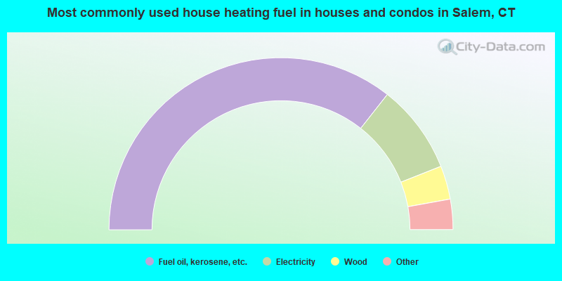
- 71.3%Fuel oil, kerosene, etc.
- 16.8%Electricity
- 6.3%Wood
- 3.9%Bottled, tank, or LP gas
- 0.8%Other fuel
- 0.5%Coal or coke
- 0.5%No fuel used

- 50.5%Fuel oil, kerosene, etc.
- 36.6%Electricity
- 6.2%Bottled, tank, or LP gas
- 3.6%Utility gas
- 3.1%Coal or coke
Salem compared to Connecticut state average:
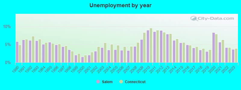
- Unemployed percentage significantly below state average.
- Black race population percentage significantly below state average.
- Hispanic race population percentage significantly below state average.
- Foreign-born population percentage significantly below state average.
- Renting percentage significantly below state average.
- Length of stay since moving in significantly above state average.
- Number of rooms per house significantly below state average.
- House age significantly below state average.

|
|
Total of 109 patent applications in 2008-2024.