Sagerton, Texas
Submit your own pictures of this place and show them to the world
- OSM Map
- General Map
- Google Map
- MSN Map

| Males: 121 | |
| Females: 131 |
| Median resident age: | 47.1 years |
| Texas median age: | 32.3 years |
Zip code: 79553
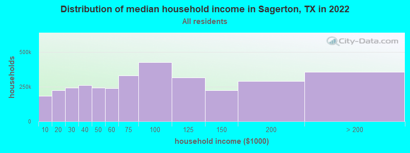
| Sagerton: | $52,770 |
| TX: | $72,284 |
Estimated per capita income in 2022: $44,337 (it was $17,310 in 2000)
Sagerton CCD income, earnings, and wages data
Estimated median house or condo value in 2022: $130,180 (it was $54,800 in 2000)
| Sagerton: | $130,180 |
| TX: | $275,400 |
Mean prices in 2022: all housing units: $115,706; detached houses: $118,384; townhouses or other attached units: $59,248; mobile homes: $79,222
Detailed information about poverty and poor residents in Sagerton, TX
Compare current foreclosures near Sagerton, TX:
| Photo | Address | Area | Beds / Baths | Price | Details |
|---|---|---|---|---|---|

|
#1
N Avenue L
Haskell, TX 79521
|
2,038 sq. feet
|
2 baths 3 beds |
show details | |

|
#2
N Avenue K
Haskell, TX 79521
|
1,720 sq. feet
|
2 baths - beds |
show details | |

|
Check over 1 million property listings on Foreclosure.com!
|
browse all offers | |||

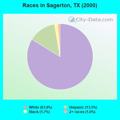
- 24883.8%White alone
- 4013.5%Hispanic
- 51.7%Black alone
- 31.0%Two or more races
Races in Sagerton detailed stats: ancestries, foreign born residents, place of birth
 Recent articles from our blog. Our writers, many of them Ph.D. graduates or candidates, create easy-to-read articles on a wide variety of topics.

Current Local Time: CST time zone
Elevation: 1634 feet
Land area: 150.1 square miles.
Population density: 1.7 people per square mile (very low).

| Sagerton CCD: | 0.8% ($427) |
| Texas: | 1.8% ($1,393) |
Nearest city with pop. 50,000+: Abilene, TX  (41.1 miles , pop. 115,930).
Nearest city with pop. 200,000+: Fort Worth, TX (148.8 miles , pop. 534,694).
Nearest city with pop. 1,000,000+: Dallas, TX (179.9 miles , pop. 1,188,580).
Nearest cities:
), ), ), ), ), )Latitude: 33.03 N, Longitude: 99.87 W

| Here: | 2.8% |
| Texas: | 3.5% |
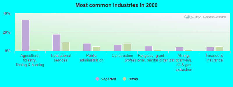
- Agriculture, forestry, fishing & hunting (33.1%)
- Educational services (17.7%)
- Public administration (8.1%)
- Construction (6.5%)
- Religious, grantmaking, civic, professional, similar organizations (4.8%)
- Mining, quarrying, oil & gas extraction (4.0%)
- Finance & insurance (4.0%)
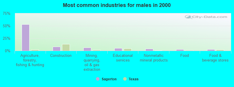
- Agriculture, forestry, fishing & hunting (52.6%)
- Construction (7.9%)
- Mining, quarrying, oil & gas extraction (6.6%)
- Educational services (5.3%)
- Nonmetallic mineral products (3.9%)
- Food (2.6%)
- Food & beverage stores (2.6%)
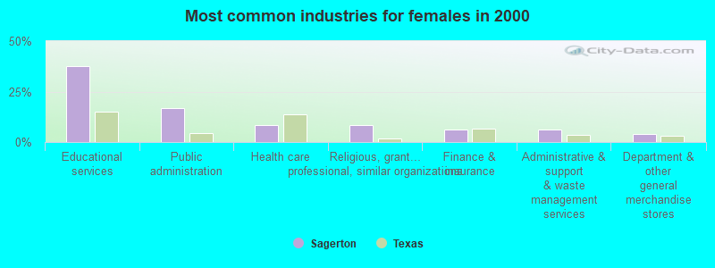
- Educational services (37.5%)
- Public administration (16.7%)
- Health care (8.3%)
- Religious, grantmaking, civic, professional, similar organizations (8.3%)
- Finance & insurance (6.2%)
- Administrative & support & waste management services (6.2%)
- Department & other general merchandise stores (4.2%)
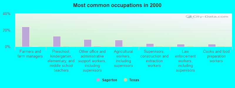
- Farmers and farm managers (24.2%)
- Preschool, kindergarten, elementary, and middle school teachers (12.9%)
- Other office and administrative support workers, including supervisors (8.9%)
- Agricultural workers, including supervisors (8.1%)
- Supervisors, construction and extraction workers (4.0%)
- Law enforcement workers, including supervisors (3.2%)
- Cooks and food preparation workers (3.2%)
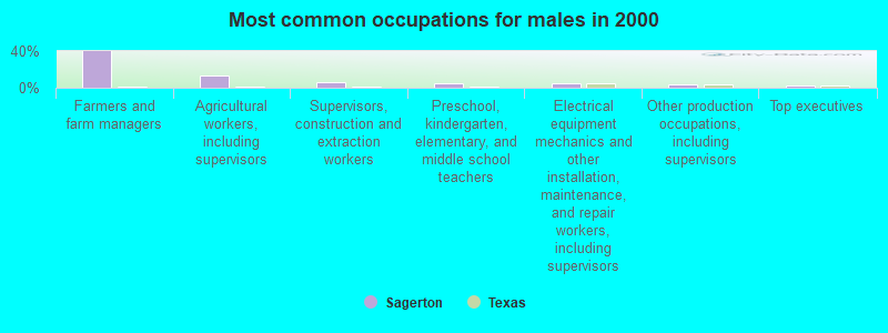
- Farmers and farm managers (39.5%)
- Agricultural workers, including supervisors (13.2%)
- Supervisors, construction and extraction workers (6.6%)
- Preschool, kindergarten, elementary, and middle school teachers (5.3%)
- Electrical equipment mechanics and other installation, maintenance, and repair workers, including supervisors (5.3%)
- Other production occupations, including supervisors (3.9%)
- Top executives (2.6%)
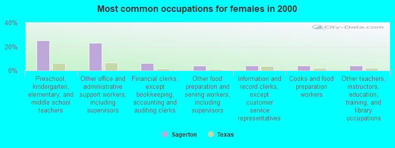
- Preschool, kindergarten, elementary, and middle school teachers (25.0%)
- Other office and administrative support workers, including supervisors (22.9%)
- Financial clerks, except bookkeeping, accounting and auditing clerks (6.2%)
- Other food preparation and serving workers, including supervisors (4.2%)
- Information and record clerks, except customer service representatives (4.2%)
- Cooks and food preparation workers (4.2%)
- Other teachers, instructors, education, training, and library occupations (4.2%)
Average climate in Sagerton, Texas
Based on data reported by over 4,000 weather stations


Tornado activity:
Sagerton-area historical tornado activity is near Texas state average. It is 45% greater than the overall U.S. average.
On 5/26/1962, a category F4 (max. wind speeds 207-260 mph) tornado 11.3 miles away from the Sagerton place center injured one person and caused between $500,000 and $5,000,000 in damages.
On 3/13/1953, a category F4 tornado 17.8 miles away from the place center killed 17 people and injured 25 people and caused between $500,000 and $5,000,000 in damages.
Earthquake activity:
Sagerton-area historical earthquake activity is significantly above Texas state average. It is 448% greater than the overall U.S. average.On 6/16/1978 at 11:46:54, a magnitude 5.3 (4.4 MB, 4.6 UK, 5.3 ML, Class: Moderate, Intensity: VI - VII) earthquake occurred 51.8 miles away from the city center
On 11/6/2011 at 03:53:10, a magnitude 5.7 (5.7 MW, Depth: 3.2 mi) earthquake occurred 247.9 miles away from Sagerton center
On 9/3/2016 at 12:02:44, a magnitude 5.8 (5.8 MW, Depth: 3.5 mi) earthquake occurred 288.3 miles away from Sagerton center
On 4/14/1995 at 00:32:56, a magnitude 5.7 (5.6 MB, 5.7 MS, 5.7 MW, Depth: 11.1 mi) earthquake occurred 280.2 miles away from Sagerton center
On 1/2/1992 at 11:45:35, a magnitude 5.0 (4.6 MB, 5.0 LG, Depth: 3.1 mi) earthquake occurred 194.0 miles away from the city center
On 9/11/2011 at 12:27:44, a magnitude 4.3 (4.3 MW, Depth: 3.1 mi, Class: Light, Intensity: IV - V) earthquake occurred 53.6 miles away from the city center
Magnitude types: regional Lg-wave magnitude (LG), body-wave magnitude (MB), local magnitude (ML), surface-wave magnitude (MS), moment magnitude (MW)
Natural disasters:
The number of natural disasters in Haskell County (11) is smaller than the US average (15).Major Disasters (Presidential) Declared: 4
Emergencies Declared: 5
Causes of natural disasters: Floods: 4, Fires: 3, Hurricanes: 3, Storms: 3, Tornadoes: 2, Wind: 1, Winter Storm: 1, Other: 1 (Note: some incidents may be assigned to more than one category).
Hospitals and medical centers near Sagerton:
- COMMUNITY CARE CENTER OF STAMFORD (Nursing Home, about 9 miles away; STAMFORD, TX)
- TEAKWOOD MANOR (Nursing Home, about 9 miles away; STAMFORD, TX)
- SAGEBRUSH LIVING CENTER (Hospital, about 9 miles away; STAMFORD, TX)
- STAMFORD MEMORIAL HOSPITAL HOME HEALTH CARE (Home Health Center, about 9 miles away; STAMFORD, TX)
- STAMFORD MEMORIAL HOSPITAL Acute Care Hospitals (about 9 miles away; STAMFORD, TX)
- HASKELL NURSING CENTER (Nursing Home, about 12 miles away; HASKELL, TX)
- HASKELL MEMORIAL HOSPITAL Critical Access Hospitals (about 12 miles away; HASKELL, TX)
Colleges/universities with over 2000 students nearest to Sagerton:
- Abilene Christian University (about 40 miles; Abilene, TX; Full-time enrollment: 4,025)
- Cisco College (about 68 miles; Cisco, TX; FT enrollment: 2,687)
- Vernon College (about 85 miles; Vernon, TX; FT enrollment: 2,216)
- Midwestern State University (about 98 miles; Wichita Falls, TX; FT enrollment: 4,901)
- Howard College (about 107 miles; Big Spring, TX; FT enrollment: 2,587)
- Tarleton State University (about 112 miles; Stephenville, TX; FT enrollment: 8,882)
- Angelo State University (about 116 miles; San Angelo, TX; FT enrollment: 6,019)
Points of interest:
Notable location: Flat Top Ranch (A). Display/hide its location on the map
Cemeteries: Capron Cemetery (1), Stamford Cemetery (2), Highland Cemetery (3). Display/hide their locations on the map
Streams, rivers, and creeks: Turkey Paint Creek (A), Red Paint Creek (B), Dudleys Creek (C), Willow Creek (D), Gyp Creek (E), Deadman Branch (F), Coon Creek (G). Display/hide their locations on the map
| This place: | 2.3 people |
| Texas: | 2.8 people |
| This place: | 70.2% |
| Whole state: | 69.9% |
| This place: | 5.3% |
| Whole state: | 6.0% |
No gay or lesbian households reported
| This place: | 7.6% |
| Whole state: | 15.4% |
For population 15 years and over in Sagerton:
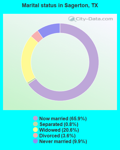
- Never married: 9.9%
- Now married: 65.9%
- Separated: 0.8%
- Widowed: 20.6%
- Divorced: 3.6%
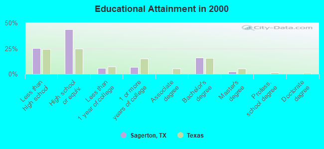
For population 25 years and over in Sagerton:
- High school or higher: 74.6%
- Bachelor's degree or higher: 18.0%
- Graduate or professional degree: 2.2%
- Unemployed: 1.6%
- Mean travel time to work (commute): 19.5 minutes
| Here: | 14.5 |
| Texas average: | 15.6 |
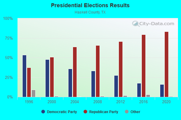
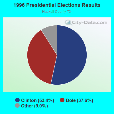
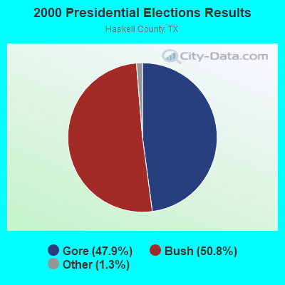
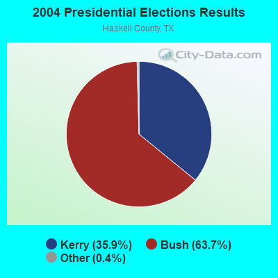
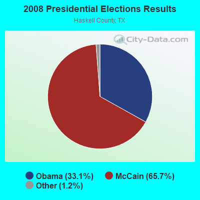
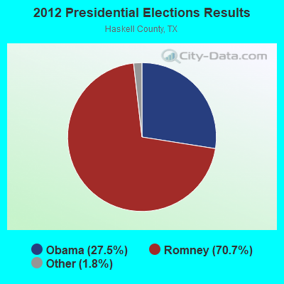
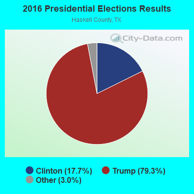
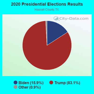
Graphs represent county-level data. Detailed 2008 Election Results
Religion statistics for Sagerton, TX (based on Haskell County data)
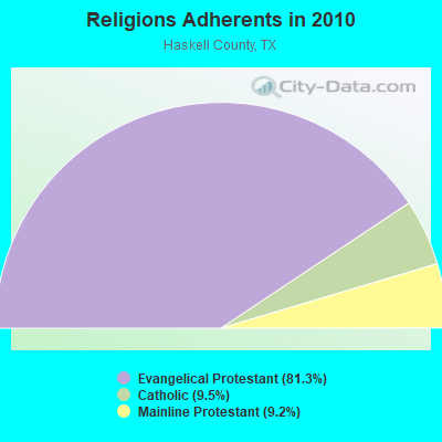
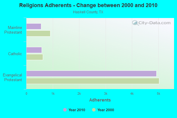
| Religion | Adherents | Congregations |
|---|---|---|
| Evangelical Protestant | 4,921 | 25 |
| Catholic | 577 | 1 |
| Mainline Protestant | 557 | 4 |
| Other | 1 | - |
| None | - | - |
Food Environment Statistics:
| Haskell County: | 5.74 / 10,000 pop. |
| Texas: | 1.47 / 10,000 pop. |
| Haskell County: | 1.91 / 10,000 pop. |
| Texas: | 1.11 / 10,000 pop. |
| Haskell County: | 3.83 / 10,000 pop. |
| State: | 3.95 / 10,000 pop. |
| Haskell County: | 11.48 / 10,000 pop. |
| Texas: | 6.13 / 10,000 pop. |
| This county: | 11.6% |
| Texas: | 8.9% |
| Haskell County: | 27.1% |
| Texas: | 26.6% |
| Haskell County: | 15.2% |
| Texas: | 15.7% |
Strongest AM radio stations in Sagerton:
- KVRP (1400 AM; 1 kW; STAMFORD, TX; Owner: ROLLINS PLAINS BROADCASTING CORP.)
- KEAN (1470 AM; 5 kW; ABILENE, TX; Owner: CCB TEXAS LICENSES, L.P.)
- WBAP (820 AM; 50 kW; FORT WORTH, TX; Owner: WBAP-KSCS OPERATING, LTD.)
- KAHZ (1360 AM; 50 kW; HURST, TX)
- KESS (1270 AM; 50 kW; FORT WORTH, TX; Owner: KESS-AM LICENSE CORP.)
- KRLD (1080 AM; 50 kW; DALLAS, TX; Owner: TEXAS INFINITY BROADCASTING L.P.)
- KZMP (1540 AM; 50 kW; UNIVERSITY PARK, TX; Owner: ENTRAVISION HOLDINGS, LLC)
- KICA (980 AM; 50 kW; CLOVIS, NM; Owner: BROADCAST ENTERTAINMENT CORPORATION)
- KKYX (680 AM; 50 kW; SAN ANTONIO, TX; Owner: CXR HOLDINGS, INC.)
- KCAF (990 AM; 10 kW; FARMERSVILLE, TX; Owner: RENAISSANCE RADIO, INC.)
- KFXR (1190 AM; 50 kW; DALLAS, TX; Owner: CLEAR CHANNEL BROADCASTING LICENSES, INC.)
- KTKR (760 AM; 50 kW; SAN ANTONIO, TX; Owner: CCB TEXAS LICENSES, L.P.)
- KSKY (660 AM; 20 kW; BALCH SPRINGS, TX; Owner: BISON MEDIA, INC.)
Strongest FM radio stations in Sagerton:
- KVRP-FM (97.1 FM; HASKELL, TX; Owner: ROLLING PLAINS BROADCASTING CORP.)
- KOES (106.9 FM; STAMFORD, TX; Owner: TEXAS GULFWEST COMMUNICATIONS CORPORATION)
- KCDD (103.7 FM; HAMLIN, TX; Owner: CUMULUS LICENSING CORP.)
- KHYS (100.7 FM; ABILENE, TX; Owner: CCB TEXAS LICENSES, L.P.)
- KEAN-FM (105.1 FM; ABILENE, TX; Owner: CCB TEXAS LICENSES, L.P.)
- KHXS (102.7 FM; MERKEL, TX; Owner: CUMULUS LICENSING CORP.)
TV broadcast stations around Sagerton:
- KIDT-LP (Channel 43; STAMFORD, TX; Owner: SAGE BROADCASTING CORP./KIDY-TV)
Sagerton fatal accident list:
Sep 26, 1994 05:05 PM, 286, Vehicles: 2, Persons: 3, Fatalities: 1
FCC Registered Amateur Radio Licenses:
2- Call Sign: KB5GXO, Licensee ID: L01143207, Grant Date: 03/06/2018, Expiration Date: 05/22/2028, Cancellation Date: 11/24/2018, Certifier: Bruce W Toney, Registrant: Bruce W Toney, 2324 State Highway 283, Sagerton, TX 79548
- Call Sign: W5BT, Previous Call Sign: KB5GXO, Licensee ID: L01143207, Grant Date: 11/24/2018, Expiration Date: 11/24/2028, Certifier: Bruce W Toney, Registrant: Bruce W Toney, 2324 State Highway 283, Sagerton, TX 79548
FAA Registered Aircraft:
1- Aircraft: JERRY D HALL KITFOX SUPER SPORT 7 (Category: Land, Seats: 2, Weight: Up to 12,499 Pounds), Engine: 2 Cycle
N-Number: 817JH, N817JH, N-817JH, Serial Number: KA11251204, Certificate Issue Date: 03/21/2012
Registrant (Individual): Jerry D Hall, 507 County Road 482, Sagerton, TX 79548
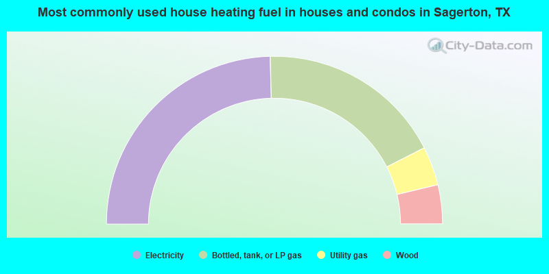
- 49.2%Electricity
- 35.8%Bottled, tank, or LP gas
- 7.5%Utility gas
- 7.5%Wood
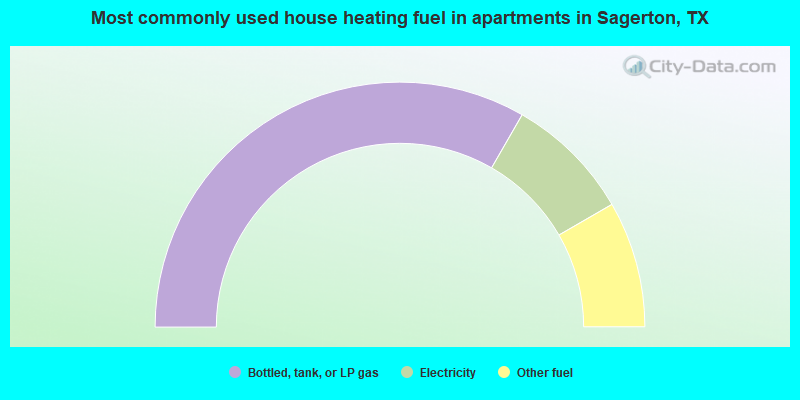
- 66.7%Bottled, tank, or LP gas
- 16.7%Electricity
- 16.7%Other fuel
Sagerton compared to Texas state average:
- Median house value below state average.
- Unemployed percentage significantly below state average.
- Black race population percentage significantly below state average.
- Hispanic race population percentage significantly below state average.
- Median age significantly above state average.
- Foreign-born population percentage significantly below state average.
- Renting percentage below state average.
- Length of stay since moving in significantly above state average.
- Number of rooms per house significantly below state average.
- House age significantly below state average.
- Number of college students below state average.