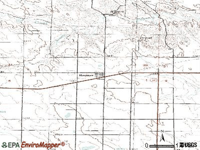
Raymer, Colorado
Submit your own pictures of this town and show them to the world
- OSM Map
- General Map
- Google Map
- MSN Map

Population change since 2000: +20.9%
 |
| Males: 64 | |
| Females: 46 |
| Median resident age: | 36.3 years |
| Colorado median age: | 37.7 years |
Zip code: 80742
| Raymer: | $37,219 |
| CO: | $89,302 |
Estimated per capita income in 2022: $31,413 (it was $8,470 in 2000)
Estimated median house or condo value in 2022: $152,144 (it was $58,800 in 2000)
| Raymer: | $152,144 |
| CO: | $531,100 |
Mean prices in 2022: all housing units: $171,256; detached houses: $191,059; mobile homes: $59,755
Median gross rent in 2022: $783.
Detailed information about poverty and poor residents in Raymer, CO
Compare current foreclosures near Raymer, CO:
| Photo | Address | Area | Beds / Baths | Price | Details |
|---|---|---|---|---|---|

|
#1
County Road 5
Merino, CO 80741
|
14,120 sq. feet
|
- baths - beds |
show details | |

|
Check over 1 million property listings on Foreclosure.com!
|
browse all offers | |||

- 8585.9%White alone
- 1313.1%Other race alone
- 55.1%Two or more races

 Recent articles from our blog. Our writers, many of them Ph.D. graduates or candidates, create easy-to-read articles on a wide variety of topics.

 | Ideas for Affordable Places to own a property in CO or AZ or WA or somewhere West (38 replies) |
| Official 2020-2021 Colorado Winter and Snow Thread (96 replies) |
| Official 2019-2020 Colorado Winter and Snow Thread (52 replies) |
| Northeast Colorado Road Trips: What to see? (10 replies) |
| Sterling for single parents (4 replies) |
| Deer and Predator hunting around Greeley (6 replies) |
Latest news from Raymer, CO collected exclusively by city-data.com from local newspapers, TV, and radio stations
Ancestries: American (25.0%), European (25.0%), Italian (25.0%), Eastern European (18.7%), Scotch-Irish (6.2%).
Current Local Time: MST time zone
Elevation: 4770 feet
Land area: 0.71 square miles.
Population density: 155 people per square mile (very low).

| Raymer town: | 0.9% ($543) |
| Colorado: | 0.7% ($1,132) |
Nearest city with pop. 50,000+: Greeley, CO  (48.2 miles , pop. 76,930).
Nearest city with pop. 200,000+: West Adams, CO (79.1 miles , pop. 259,628).
Nearest city with pop. 1,000,000+: Dallas, TX (666.4 miles , pop. 1,188,580).
Nearest cities:
), Latitude: 40.61 N, Longitude: 103.84 W
Area code commonly used in this area: 970


| Here: | 3.3% |
| Colorado: | 3.2% |
Average climate in Raymer, Colorado
Based on data reported by over 4,000 weather stations


Tornado activity:
Raymer-area historical tornado activity is above Colorado state average. It is 32% greater than the overall U.S. average.
On 5/10/1975, a category F3 (max. wind speeds 158-206 mph) tornado 35.1 miles away from the Raymer town center caused between $5000 and $50,000 in damages.
On 8/15/1974, a category F3 tornado 35.7 miles away from the town center caused between $50,000 and $500,000 in damages.
Earthquake activity:
Raymer-area historical earthquake activity is significantly above Colorado state average. It is 548% greater than the overall U.S. average.On 8/18/1959 at 06:37:13, a magnitude 7.7 (7.7 UK, Class: Major, Intensity: VIII - XII) earthquake occurred 441.6 miles away from Raymer center, causing $26,000,000 total damage
On 10/18/1984 at 15:30:23, a magnitude 5.5 (5.4 MB, 5.1 MS, 5.5 ML, Class: Moderate, Intensity: VI - VII) earthquake occurred 152.5 miles away from the city center
On 10/28/1983 at 14:06:06, a magnitude 7.3 (6.2 MB, 7.3 MS, 7.0 MW) earthquake occurred 562.3 miles away from Raymer center, causing 2 deaths (2 shaking deaths) and 3 injuries, causing $15,000,000 total damage
On 8/23/2011 at 05:46:18, a magnitude 5.3 (5.3 MW, Depth: 2.5 mi) earthquake occurred 249.6 miles away from the city center
On 3/28/1975 at 02:31:05, a magnitude 6.2 (6.1 MB, 6.0 MS, 6.2 ML, Class: Strong, Intensity: VII - IX) earthquake occurred 458.6 miles away from Raymer center
On 9/8/1984 at 00:59:31, a magnitude 5.1 (5.1 MB) earthquake occurred 272.0 miles away from the city center
Magnitude types: body-wave magnitude (MB), local magnitude (ML), surface-wave magnitude (MS), moment magnitude (MW)
Natural disasters:
The number of natural disasters in Weld County (15) is near the US average (15).Major Disasters (Presidential) Declared: 11
Emergencies Declared: 3
Causes of natural disasters: Storms: 8, Floods: 7, Landslides: 3, Mudslides: 3, Tornadoes: 2, Fire: 1, Flash Flood: 1, Heavy Rain: 1, Hurricane: 1, Snow: 1, Snowstorm: 1, Other: 2 (Note: some incidents may be assigned to more than one category).
Colleges/universities with over 2000 students nearest to Raymer:
- University of Northern Colorado (about 48 miles; Greeley, CO; Full-time enrollment: 11,469)
- Aims Community College (about 51 miles; Greeley, CO; FT enrollment: 3,598)
- Laramie County Community College (about 60 miles; Cheyenne, WY; FT enrollment: 3,288)
- Colorado State University-Fort Collins (about 66 miles; Fort Collins, CO; FT enrollment: 25,099)
- Community College of Aurora (about 80 miles; Aurora, CO; FT enrollment: 4,730)
- Front Range Community College (about 80 miles; Westminster, CO; FT enrollment: 14,756)
- Regis University (about 85 miles; Denver, CO; FT enrollment: 6,975)
Public high school in Raymer:
- PRAIRIE JUNIOR-SENIOR HIGH SCHOOL (Students: 70, Location: 42315 WCR 133, Grades: 6-12)
Public elementary/middle school in Raymer:
- PRAIRIE ELEMENTARY SCHOOL (Students: 96, Location: 42315 WCR 133, Grades: PK-5)
Points of interest:
Notable location: New Raymer - Stoneham Fire Department (A). Display/hide its location on the map
Birthplace of: Eugene F. Tighe - General.
| This town: | 2.6 people |
| Colorado: | 2.5 people |
| This town: | 81.1% |
| Whole state: | 63.9% |
| This town: | 5.4% |
| Whole state: | 6.5% |
No gay or lesbian households reported
For population 15 years and over in Raymer:

- Never married: 51.5%
- Now married: 30.2%
- Separated: 1.0%
- Widowed: 8.1%
- Divorced: 9.1%
For population 25 years and over in Raymer:
- High school or higher: 81.8%
- Bachelor's degree or higher: 14.3%
- Graduate or professional degree: 2.6%
- Unemployed: 4.8%
- Mean travel time to work (commute): 25.4 minutes


| Here: | 11.8 |
| Colorado average: | 11.1 |
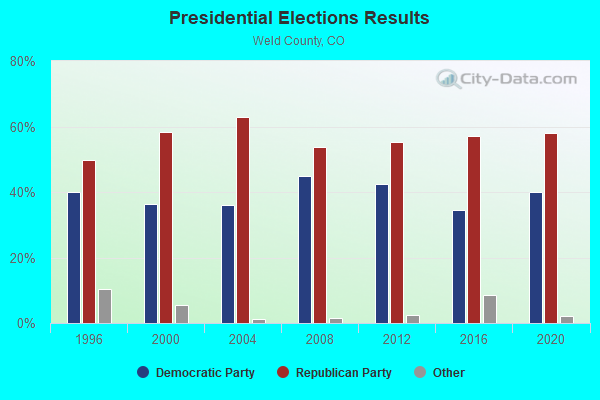
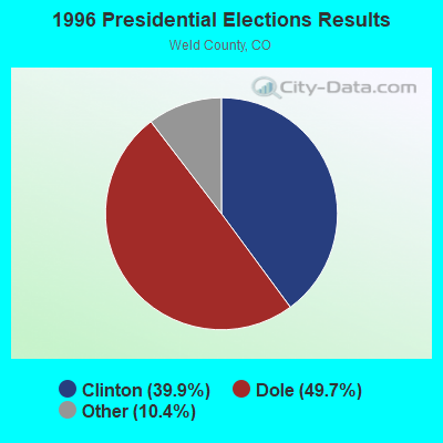
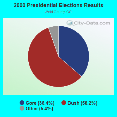
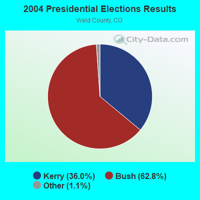
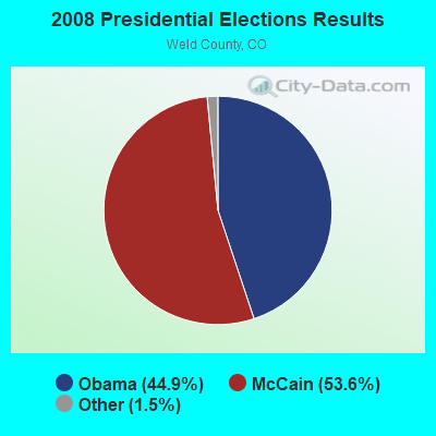
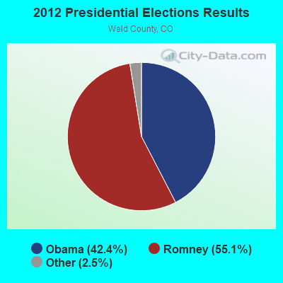
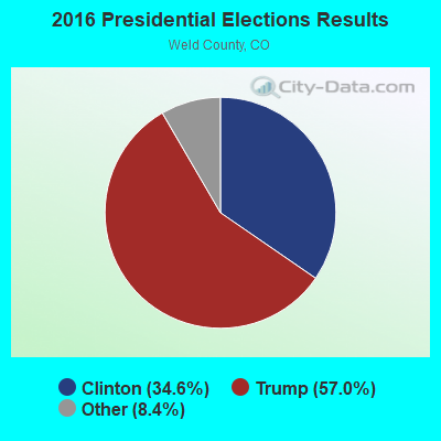
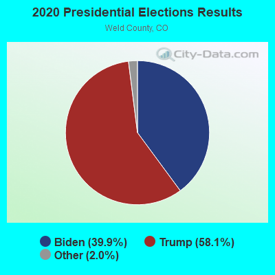
Graphs represent county-level data. Detailed 2008 Election Results
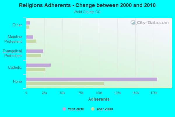
Religion statistics for Raymer, CO (based on Weld County data)
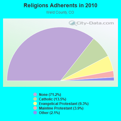
| Religion | Adherents | Congregations |
|---|---|---|
| Catholic | 34,138 | 14 |
| Evangelical Protestant | 23,467 | 133 |
| Mainline Protestant | 9,810 | 36 |
| Other | 5,365 | 21 |
| Orthodox | 35 | 1 |
| None | 180,010 | - |
Food Environment Statistics:
| Weld County: | 1.03 / 10,000 pop. |
| Colorado: | 1.50 / 10,000 pop. |
| This county: | 0.12 / 10,000 pop. |
| Colorado: | 0.15 / 10,000 pop. |
| Weld County: | 0.04 / 10,000 pop. |
| Colorado: | 0.45 / 10,000 pop. |
| This county: | 2.80 / 10,000 pop. |
| Colorado: | 3.13 / 10,000 pop. |
| This county: | 5.77 / 10,000 pop. |
| Colorado: | 8.99 / 10,000 pop. |
| This county: | 5.3% |
| Colorado: | 5.3% |
| Here: | 23.0% |
| Colorado: | 18.4% |
| Weld County: | 11.5% |
| Colorado: | 9.6% |
Health and Nutrition:
| This city: | 47.4% |
| State: | 49.4% |
| Here: | 48.1% |
| State: | 47.8% |
| Raymer: | 27.3 |
| State: | 28.5 |
| This city: | 18.4% |
| State: | 20.7% |
| Raymer: | 6.9% |
| Colorado: | 9.7% |
| Raymer: | 6.9 |
| Colorado: | 6.8 |
| This city: | 32.1% |
| Colorado: | 33.3% |
| Raymer: | 54.3% |
| Colorado: | 57.3% |
| This city: | 83.4% |
| Colorado: | 80.2% |
More about Health and Nutrition of Raymer, CO Residents
| Local government employment and payroll (March 2022) | |||||
| Function | Full-time employees | Monthly full-time payroll | Average yearly full-time wage | Part-time employees | Monthly part-time payroll |
|---|---|---|---|---|---|
| Water Supply | 0 | $0 | 2 | $600 | |
| Totals for Government | 0 | $0 | 2 | $600 | |
Strongest AM radio stations in Raymer:
- KSIR (1010 AM; 25 kW; BRUSH, CO; Owner: JMS BROADCASTING, LLC)
- KIMB (1260 AM; 50 kW; KIMBALL, NE; Owner: G & L INVESTMENTS, LLC)
- KLTT (670 AM; 50 kW; COMMERCE CITY, CO; Owner: KLZ RADIO, INC.)
- KKZN (760 AM; 50 kW; THORNTON, CO; Owner: JACOR BROADCASTING OF COLORADO, INC.)
- KMXA (1090 AM; 50 kW; AURORA, CO; Owner: ENTRAVISION HOLDINGS, LLC)
- KOA (850 AM; 50 kW; DENVER, CO; Owner: JACOR BROADCASTING OF COLORADO, INC.)
- KLMO (1060 AM; 30 kW; LONGMONT, CO; Owner: PILGRIM COMMUNICATIONS, INC.)
- KGAB (650 AM; 8 kW; ORCHARD VALLEY, WY; Owner: CITICASTERS LICENSES, L.P.)
- KHNC (1360 AM; 10 kW; JOHNSTOWN, CO; Owner: DONALD A. AND SHARON E. WIEDEMAN)
- KJJL (1370 AM; 10 kW; CHEYENNE, WY; Owner: CHRISTUS BROADCASTING, INC.)
- KCOL (600 AM; 5 kW; WELLINGTON, CO; Owner: JACOR BROADCASTING OF COLORADO, INC.)
- KCUV (1510 AM; 25 kW; LITTLETON, CO; Owner: PEOPLE WIRELESS, INC.)
- KKWY (1630 AM; 10 kW; FOX FARM, WY; Owner: CHRISTUS BROADCASTING, INC.)
Strongest FM radio stations in Raymer:
- KBRU-FM (101.7 FM; FORT MORGAN, CO; Owner: ON-AIR FAMILY, LLC)
Raymer fatal accident list:
- National Bridge Inventory (NBI) Statistics
- 1Number of bridges
- 7ft / 2.0mTotal length
- 576Total average daily traffic
- 322Total average daily truck traffic
- 818Total future (year 2041) average daily traffic
FCC Registered Microwave Towers:
7- NEW RAYMER, Rt 14 (Lat: 40.608194 Lon: -103.830444), Type: Ltower, Structure height: 57.9 m, Call Sign: WQUI719,
Assigned Frequencies: 6585.00 MHz, 6585.00 MHz, 6585.00 MHz, 6655.62 MHz, 6585.00 MHz, Grant Date: 07/18/2014, Expiration Date: 07/18/2024, Certifier: Richard Schmidt, Registrant: State Of Colorado, 601 E. 18th Avenue, Suite 250, Denver, CO 80203, Phone: (303) 764-7700, Fax: (303) 764-7764, Email:
- RAZOR, .8k Sw Of The Intersection Of County Road 116 And 127 In Weld County Colorado (Lat: 40.824056 Lon: -103.864000), Type: Ltower, Structure height: 19 m, Call Sign: WQUX228,
Assigned Frequencies: 19520.0 MHz, 19520.0 MHz, 19520.0 MHz, 19520.0 MHz, 19520.0 MHz, 19520.0 MHz, 19520.0 MHz, 19560.0 MHz, 19560.0 MHz, 19560.0 MHz... (+4 more), Grant Date: 11/05/2014, Expiration Date: 11/05/2024, Certifier: Terry Steege, Registrant: Action Communications, Inc., 315 West 27th Street, Scottsbluff, NE 69361, Phone: (308) 632-7836, Fax: (308) 632-5684, Email:
- NELSON, 3.2k West Of The Intersection Of County Roads 118 And 127 In Weld County Colorad (Lat: 40.846639 Lon: -103.899194), Type: Ltower, Structure height: 43 m, Call Sign: WQUY736,
Assigned Frequencies: 18000.0 MHz, 18040.0 MHz, 18000.0 MHz, 18040.0 MHz, 18000.0 MHz, 18040.0 MHz, 18000.0 MHz, 18040.0 MHz, 18000.0 MHz, 18040.0 MHz... (+4 more), Grant Date: 11/19/2014, Expiration Date: 11/19/2024, Certifier: Terry Steege, Registrant: Action Communications, Inc., 315 West 27th Street, Scottsbluff, NE 69361, Phone: (308) 632-7836, Fax: (308) 632-5684, Email:
- NELSON RELAY, 1k East Of County Roads 124 & 111 (Lat: 40.891167 Lon: -103.996194), Type: Pole, Structure height: 16 m, Overall height: 18 m, Call Sign: WQUZ810,
Assigned Frequencies: 19560.0 MHz, 19560.0 MHz, 19560.0 MHz, 19560.0 MHz, 19560.0 MHz, 19560.0 MHz, 19560.0 MHz, 19520.0 MHz, 19600.0 MHz, 19520.0 MHz... (+11 more), Grant Date: 12/02/2014, Expiration Date: 12/02/2024, Certifier: Terry Steege, Registrant: Action Communications, Inc., 315 West 27th Street, Scottsbluff, NE 69361, Phone: (308) 632-7836, Fax: (308) 632-5684, Email:
- RAZOR RPTR, 3.7k Ne Of The Intersection Of Co Rd 127 And Co Rd 118 (Lat: 40.871722 Lon: -103.832056), Type: Pole, Structure height: 16.8 m, Call Sign: WQYD712,
Assigned Frequencies: 17960.0 MHz, 17960.0 MHz, 17960.0 MHz, 17960.0 MHz, 17960.0 MHz, 17960.0 MHz, 17960.0 MHz, Grant Date: 08/25/2016, Expiration Date: 08/25/2026, Certifier: Terry Steege, Registrant: Action Communications, Inc., 315 West 27th Street, Scottsbluff, NE 69361, Phone: (308) 632-7836, Fax: (308) 632-5684, Email:
- DN02820B, Co-14 (Lat: 40.607306 Lon: -103.831028), Type: Ltower, Structure height: 54.6 m, Call Sign: WRWP549,
Assigned Frequencies: 11565.0 MHz, 11645.0 MHz, 11565.0 MHz, 11645.0 MHz, 11565.0 MHz, 11645.0 MHz, 11565.0 MHz, 11645.0 MHz, 11565.0 MHz, 11645.0 MHz... (+12 more), Grant Date: 03/14/2023, Expiration Date: 03/14/2033, Certifier: Jenny Knopf, Registrant: T-Mobile Usa, Inc., 12920 Se 38th Street, Bellevue, WA 98006, Phone: (425) 383-8401, Fax: (425) 383-4040, Email:
- Raymer Comp, 38255 Wcr 129 (Lat: 40.556361 Lon: -103.841611), Type: Silo, Structure height: 15.2 m, Call Sign: WRZA802,
Assigned Frequencies: 11155.0 MHz, 11155.0 MHz, 11405.0 MHz, 11405.0 MHz, 11645.0 MHz, 11645.0 MHz, 10915.0 MHz, 10915.0 MHz, Grant Date: 10/11/2023, Expiration Date: 10/11/2033, Certifier: Clint Kocurek, Registrant: Intelpath, Hinsdale, IL 60522, Phone: (312) 841-9188, Email:
FCC Registered Amateur Radio Licenses:
1- Call Sign: KC0KWH, Licensee ID: L00366718, Grant Date: 04/12/2011, Expiration Date: 06/12/2021, Cancellation Date: 07/12/2023, Certifier: John J Hill Jr, Registrant: John J Hill Jr, 47 Shirley Ave., Raymer, CO 80742-0104

- 60.0%Bottled, tank, or LP gas
- 32.0%Electricity
- 8.0%Utility gas

- 100.0%Bottled, tank, or LP gas
Raymer compared to Colorado state average:
- Median household income significantly below state average.
- Median house value significantly below state average.
- Unemployed percentage significantly below state average.
- Black race population percentage significantly below state average.
- Hispanic race population percentage significantly below state average.
- Median age above state average.
- Foreign-born population percentage significantly below state average.
- Renting percentage below state average.
- Length of stay since moving in significantly above state average.
- House age above state average.
- Number of college students significantly below state average.
- Percentage of population with a bachelor's degree or higher below state average.