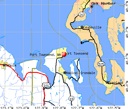
Port Townsend, Washington
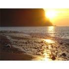
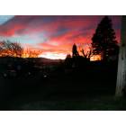
Port Townsend: Port Townsend Sunset
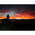
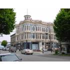
Port Townsend: Clock Tower at Sunset
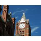
Port Townsend: Historic Clock Tower in Port Townsend
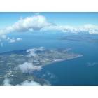
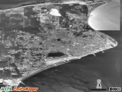
Port Townsend: Port Townsend form the air
Port Townsend: Clock Tower, Washington Street, Thanksgiving 2002
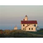
Port Townsend: Port Townsend Lighthouse
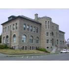
Port Townsend: Post Office Building
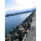
Port Townsend: Ferry Dock - Port Townsend WA
Port Townsend: Old downtown Port Townsend
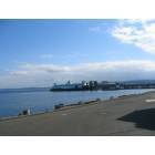
Port Townsend: Ferry to Whidbey Island - Port Townsend WA
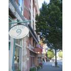
Port Townsend: Water Street - Port Townsend WA
- see
28
more - add
your


Submit your own pictures of this city and show them to the world
- OSM Map
- General Map
- Google Map
- MSN Map
Population change since 2000: +24.6%
 |
| Males: 4,717 | |
| Females: 5,671 |
| Median resident age: | 60.1 years |
| Washington median age: | 38.4 years |
Zip codes: 98368.
| Port Townsend: | $59,836 |
| WA: | $91,306 |
Estimated per capita income in 2022: $44,998 (it was $22,395 in 2000)
Port Townsend city income, earnings, and wages data
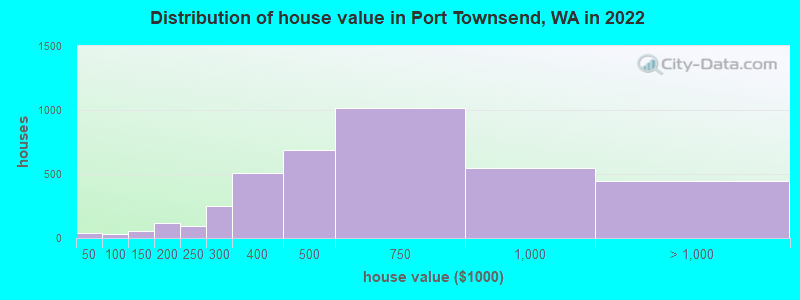
Estimated median house or condo value in 2022: $539,425 (it was $145,500 in 2000)
| Port Townsend: | $539,425 |
| WA: | $569,500 |
Mean prices in 2022: all housing units: $569,027; detached houses: $615,312; townhouses or other attached units: $575,060; in 2-unit structures: $731,132; in 3-to-4-unit structures: $215,019; in 5-or-more-unit structures: $376,073; mobile homes: $236,484; occupied boats, rvs, vans, etc.: $134,887
Median gross rent in 2022: $1,137.
(11.6% for White Non-Hispanic residents, 38.9% for Black residents, 35.1% for Hispanic or Latino residents, 70.0% for American Indian residents, 23.2% for other race residents, 35.4% for two or more races residents)
Detailed information about poverty and poor residents in Port Townsend, WA


Compare current foreclosures near Port Townsend, WA:
| Photo | Address | Area | Beds / Baths | Price | Details |
|---|---|---|---|---|---|

|
#1
Cape George Rd
Port Townsend, WA 98368
|
1,080 sq. feet
|
2 baths 3 beds |
show details | |

|
#2
Highway 20
Port Townsend, WA 98368
|
1,182 sq. feet
|
2 baths 3 beds |
show details | |

|
#3
Haines St
Port Townsend, WA 98368
|
1,336 sq. feet
|
2 baths 3 beds |
show details | |

|
#4
W Rosecrans Ct
Port Townsend, WA 98368
|
- sq. feet
|
- baths - beds |
show details | |

|
#5
O St
Port Townsend, WA 98368
|
- sq. feet
|
- baths - beds |
show details | |

|
#6
Washington St Unit 2028
Port Townsend, WA 98368
|
- sq. feet
|
- baths - beds |
show details | |

|
#7
Engel Rd
Port Townsend, WA 98368
|
- sq. feet
|
- baths - beds |
show details | |

|
#8
W Sims Way, Pmb 471
Port Townsend, WA 98368
|
- sq. feet
|
- baths - beds |
show details | |

|
#9
30th St
Port Townsend, WA 98368
|
- sq. feet
|
- baths - beds |
show details | |

|
#10
Jolie Way
Port Townsend, WA 98368
|
- sq. feet
|
- baths - beds |
show details |
| Photo | Address | Area | Beds / Baths | Price | Details |
|---|---|---|---|---|---|

|
#11
Lola Ln
Langley, WA 98260
|
1,311 sq. feet
|
2 baths 2 beds |
show details | |

|
#12
NE 3rd Ave
Oak Harbor, WA 98277
|
1,138 sq. feet
|
1 baths 3 beds |
show details | |

|
#13
Harbor Sands Ln
Freeland, WA 98249
|
864 sq. feet
|
1 baths 2 beds |
show details | |

|
#14
Wahl Rd
Freeland, WA 98249
|
1,512 sq. feet
|
1 baths 3 beds |
show details | |

|
#15
Donald Ave
Oak Harbor, WA 98277
|
1,006 sq. feet
|
1 baths 1 beds |
show details | |

|
#16
NW 8th Ave
Oak Harbor, WA 98277
|
1,314 sq. feet
|
2 baths 3 beds |
show details | |

|
#17
Frayne St
Port Hadlock, WA 98339
|
1,404 sq. feet
|
2 baths 3 beds |
show details | |

|
#18
SW Talon Loop
Oak Harbor, WA 98277
|
1,809 sq. feet
|
2 baths 3 beds |
show details | |

|
#19
SW Periwinkle Ln
Oak Harbor, WA 98277
|
1,980 sq. feet
|
2 baths 4 beds |
show details | |

|
#20
Dogwood Ln
Camano Island, WA 98282
|
2,652 sq. feet
|
3 baths 4 beds |
show details |
| Photo | Address | Area | Beds / Baths | Price | Details |
|---|---|---|---|---|---|

|
#21
SW 10th Ct
Oak Harbor, WA 98277
|
2,064 sq. feet
|
2 baths 3 beds |
show details | |

|
#22
Dolphin St
Camano Island, WA 98282
|
1,432 sq. feet
|
2 baths 2 beds |
show details | |

|
#23
Colonial Way
Oak Harbor, WA 98277
|
1,424 sq. feet
|
2 baths 3 beds |
show details | |

|
#24
NE 8th Ave
Oak Harbor, WA 98277
|
1,680 sq. feet
|
2 baths 3 beds |
show details | |

|
#25
Rainier Ln
Port Ludlow, WA 98365
|
1,470 sq. feet
|
2 baths 3 beds |
show details | |

|
#26
SW Xavier Dr
Oak Harbor, WA 98277
|
2,170 sq. feet
|
2 baths 3 beds |
show details | |

|
#27
Links Way
Oak Harbor, WA 98277
|
2,766 sq. feet
|
2 baths 3 beds |
show details | |

|
#28
Thompson Dr
Camano Island, WA 98282
|
1,475 sq. feet
|
3 baths 3 beds |
show details | |

|
#29
Admiralty Way
Camano Island, WA 98282
|
2,127 sq. feet
|
3 baths 3 beds |
show details | |

|
#30
Flagler Rd
Nordland, WA 98358
|
864 sq. feet
|
1 baths 1 beds |
show details |
| Photo | Address | Area | Beds / Baths | Price | Details |
|---|---|---|---|---|---|

|
#31
Summit St
Camano Island, WA 98282
|
1,439 sq. feet
|
2 baths 2 beds |
show details | |

|
#32
Mountain View Ln
Freeland, WA 98249
|
1,414 sq. feet
|
2 baths 3 beds |
show details | |

|
#33
Wanamaker Rd
Coupeville, WA 98239
|
1,532 sq. feet
|
1 baths 3 beds |
show details | |

|
#34
Parker Rd
Coupeville, WA 98239
|
964 sq. feet
|
2 baths 3 beds |
show details | |

|
#35
S Sapphire Dr
Camano Island, WA 98282
|
1,476 sq. feet
|
2 baths 2 beds |
show details | |

|
#36
Thompson Rd
Langley, WA 98260
|
2,208 sq. feet
|
1 baths 1 beds |
show details | |

|
#37
Seaview Ave
Coupeville, WA 98239
|
1,746 sq. feet
|
2 baths 3 beds |
show details | |

|
#38
Seaside Dr
Coupeville, WA 98239
|
1,983 sq. feet
|
3 baths 4 beds |
show details | |

|
#39
Bower Ln # A
Camano Island, WA 98282
|
1,056 sq. feet
|
2 baths - beds |
show details | |

|
#40
SE 2nd Ct
Oak Harbor, WA 98277
|
1,670 sq. feet
|
2 baths - beds |
show details |
| Photo | Address | Area | Beds / Baths | Price | Details |
|---|---|---|---|---|---|

|
#41
Classic Rd
Greenbank, WA 98253
|
- sq. feet
|
2 baths 3 beds |
show details | |

|
#42
SW Beeksma Dr
Oak Harbor, WA 98277
|
2,144 sq. feet
|
3 baths - beds |
show details | |

|
#43
Heller Rd, Trlr 60
Oak Harbor, WA 98277
|
- sq. feet
|
- baths - beds |
show details | |

|
#44
Heller Rd, Trlr 5
Oak Harbor, WA 98277
|
- sq. feet
|
- baths - beds |
show details | |

|
#45
Sunset Pl
Sequim, WA 98382
|
1,398 sq. feet
|
- baths - beds |
show details | |

|
#46
W Cedar St Apt 5
Sequim, WA 98382
|
- sq. feet
|
- baths - beds |
show details | |

|
#47
Sunset Pl
Sequim, WA 98382
|
1,398 sq. feet
|
- baths - beds |
show details | |

|
#48
Western Dr
Oak Harbor, WA 98277
|
- sq. feet
|
- baths - beds |
show details | |

|
#49
NE 24th Ln
Oak Harbor, WA 98277
|
- sq. feet
|
- baths - beds |
show details | |

|
Check over 1 million property listings on Foreclosure.com!
|
browse all offers | |||


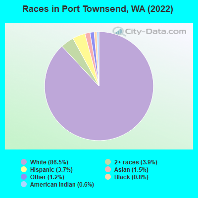
- 8,90186.5%White alone
- 4003.9%Two or more races
- 3793.7%Hispanic
- 1531.5%Asian alone
- 1201.2%Other race alone
- 830.8%Black alone
- 610.6%American Indian alone
- 20.02%Native Hawaiian and Other
Pacific Islander alone
Races in Port Townsend detailed stats: ancestries, foreign born residents, place of birth
According to our research of Washington and other state lists, there was 1 registered sex offender living in Port Townsend, Washington as of May 08, 2024.
The ratio of all residents to sex offenders in Port Townsend is 9,568 to 1.
The ratio of registered sex offenders to all residents in this city is much lower than the state average.
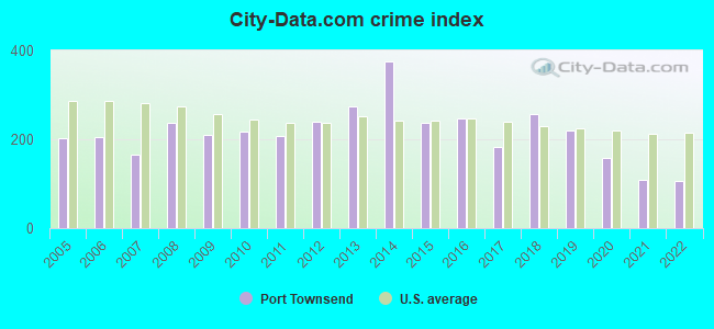
Type |
2009 |
2010 |
2011 |
2012 |
2013 |
2014 |
2015 |
2016 |
2017 |
2018 |
2019 |
2020 |
2021 |
2022 |
|---|---|---|---|---|---|---|---|---|---|---|---|---|---|---|
| Murders (per 100,000) | 0 (0.0) | 0 (0.0) | 0 (0.0) | 0 (0.0) | 0 (0.0) | 0 (0.0) | 0 (0.0) | 1 (10.7) | 0 (0.0) | 3 (31.2) | 0 (0.0) | 0 (0.0) | 0 (0.0) | 0 (0.0) |
| Rapes (per 100,000) | 0 (0.0) | 0 (0.0) | 2 (21.6) | 7 (75.9) | 5 (54.9) | 9 (97.5) | 4 (43.1) | 3 (32.0) | 4 (41.7) | 7 (72.8) | 8 (81.8) | 2 (20.2) | 2 (19.9) | 0 (0.0) |
| Robberies (per 100,000) | 4 (43.4) | 1 (11.0) | 4 (43.2) | 1 (10.8) | 1 (11.0) | 4 (43.3) | 2 (21.5) | 1 (10.7) | 5 (52.1) | 2 (20.8) | 1 (10.2) | 4 (40.3) | 2 (19.9) | 1 (9.6) |
| Assaults (per 100,000) | 12 (130.1) | 16 (175.6) | 18 (194.5) | 12 (130.2) | 36 (395.1) | 45 (487.5) | 28 (301.5) | 19 (202.6) | 21 (218.8) | 20 (208.0) | 32 (327.2) | 13 (131.1) | 11 (109.3) | 18 (172.2) |
| Burglaries (per 100,000) | 74 (802.3) | 76 (834.0) | 55 (594.2) | 55 (596.6) | 68 (746.3) | 95 (1,029) | 71 (764.4) | 70 (746.4) | 35 (364.7) | 33 (343.2) | 39 (398.8) | 42 (423.6) | 24 (238.5) | 24 (229.6) |
| Thefts (per 100,000) | 243 (2,635) | 239 (2,623) | 203 (2,193) | 224 (2,430) | 196 (2,151) | 242 (2,622) | 181 (1,949) | 230 (2,453) | 130 (1,355) | 132 (1,373) | 125 (1,278) | 156 (1,574) | 94 (934.1) | 106 (1,014) |
| Auto thefts (per 100,000) | 10 (108.4) | 17 (186.5) | 10 (108.0) | 11 (119.3) | 11 (120.7) | 11 (119.2) | 5 (53.8) | 6 (64.0) | 11 (114.6) | 13 (135.2) | 9 (92.0) | 15 (151.3) | 13 (129.2) | 15 (143.5) |
| Arson (per 100,000) | 0 (0.0) | 2 (21.9) | 2 (21.6) | 8 (86.8) | 3 (32.9) | 3 (32.5) | 2 (21.5) | 1 (10.7) | 1 (10.4) | 7 (72.8) | 6 (61.3) | 1 (10.1) | 0 (0.0) | 2 (19.1) |
| City-Data.com crime index | 209.3 | 216.6 | 207.1 | 238.5 | 274.1 | 374.9 | 237.0 | 246.1 | 181.6 | 258.2 | 220.3 | 159.2 | 108.1 | 105.4 |
The City-Data.com crime index weighs serious crimes and violent crimes more heavily. Higher means more crime, U.S. average is 246.1. It adjusts for the number of visitors and daily workers commuting into cities.
Crime rate in Port Townsend detailed stats: murders, rapes, robberies, assaults, burglaries, thefts, arson
Full-time law enforcement employees in 2021, including police officers: 12 (10 officers - 10 male; 0 female).
| Officers per 1,000 residents here: | 0.99 |
| Washington average: | 1.35 |
 Recent articles from our blog. Our writers, many of them Ph.D. graduates or candidates, create easy-to-read articles on a wide variety of topics.


 | Port Townsend--yea or nay? (32 replies) |
| Can a down-to-earth, yoga-loving & nature-loving conservative woman feel at home in Sequim or Port Townsend, WA? (37 replies) |
| Is Port Townsend or Lake Conner scooter friendly? (12 replies) |
| If cost were not a factor, where in Washington would you live? (140 replies) |
| Looking to escape the wildfires in Oregon (39 replies) |
| moving to WA (42 replies) |
Latest news from Port Townsend, WA collected exclusively by city-data.com from local newspapers, TV, and radio stations
Ancestries: English (10.2%), Italian (9.8%), Irish (9.2%), German (8.7%), American (6.4%), European (5.6%).
Current Local Time: PST time zone
Incorporated in 1860
Elevation: 120 feet
Land area: 6.99 square miles.
Population density: 1,485 people per square mile (low).
507 residents are foreign born (1.8% Latin America, 1.6% Europe, 1.0% Asia).
| This city: | 4.9% |
| Washington: | 14.9% |
Median real estate property taxes paid for housing units with mortgages in 2022: $3,653 (0.6%)
Median real estate property taxes paid for housing units with no mortgage in 2022: $3,763 (0.8%)
Nearest city with pop. 50,000+: Everett, WA  (28.6 miles , pop. 91,488).
Nearest city with pop. 200,000+: Seattle, WA (39.6 miles , pop. 563,374).
Nearest city with pop. 1,000,000+: Los Angeles, CA (996.7 miles , pop. 3,694,820).
Nearest cities:
), ), ), ), Latitude: 48.12 N, Longitude: 122.78 W
Daytime population change due to commuting: +2,211 (+21.5%)
Workers who live and work in this city: 2,932 (81.7%)
Area code: 360

| Here: | 5.8% |
| Washington: | 4.6% |
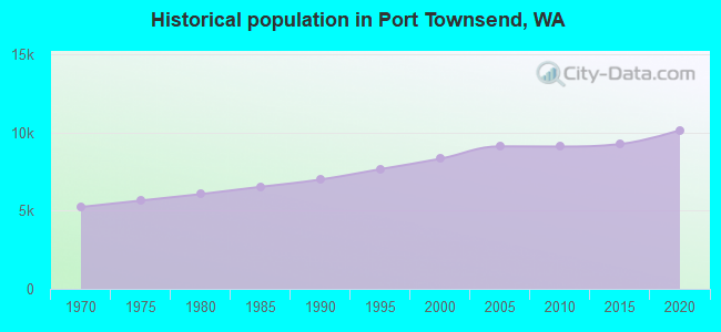
Population change in the 1990s: +1,196 (+16.8%).
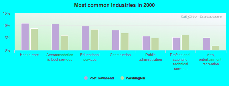
- Health care (10.9%)
- Accommodation & food services (10.7%)
- Educational services (9.7%)
- Construction (8.2%)
- Public administration (5.7%)
- Professional, scientific, technical services (5.2%)
- Arts, entertainment, recreation (5.2%)
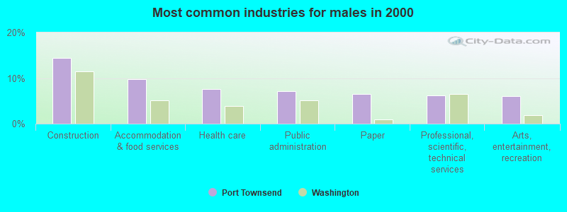
- Construction (14.4%)
- Accommodation & food services (9.8%)
- Health care (7.7%)
- Public administration (7.1%)
- Paper (6.5%)
- Professional, scientific, technical services (6.2%)
- Arts, entertainment, recreation (6.1%)
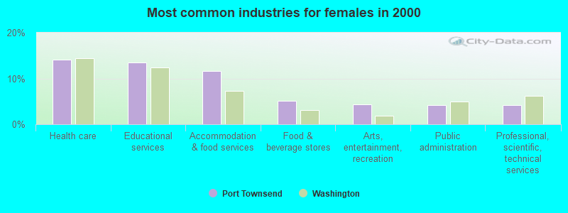
- Health care (14.1%)
- Educational services (13.5%)
- Accommodation & food services (11.6%)
- Food & beverage stores (5.1%)
- Arts, entertainment, recreation (4.3%)
- Public administration (4.2%)
- Professional, scientific, technical services (4.2%)
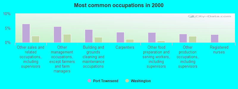
- Other sales and related occupations, including supervisors (6.5%)
- Other management occupations, except farmers and farm managers (5.6%)
- Building and grounds cleaning and maintenance occupations (4.5%)
- Carpenters (3.6%)
- Other food preparation and serving workers, including supervisors (3.5%)
- Other production occupations, including supervisors (3.0%)
- Registered nurses (2.8%)
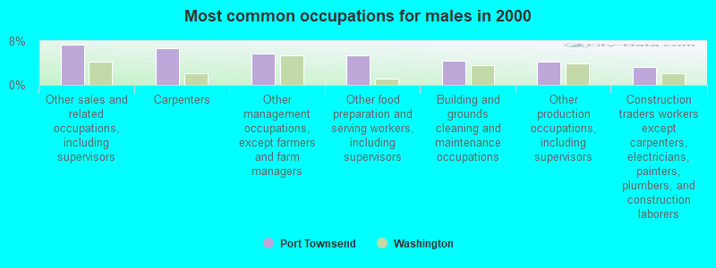
- Other sales and related occupations, including supervisors (7.4%)
- Carpenters (6.7%)
- Other management occupations, except farmers and farm managers (5.8%)
- Other food preparation and serving workers, including supervisors (5.4%)
- Building and grounds cleaning and maintenance occupations (4.5%)
- Other production occupations, including supervisors (4.2%)
- Construction traders workers except carpenters, electricians, painters, plumbers, and construction laborers (3.2%)
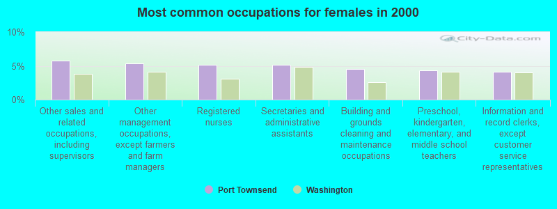
- Other sales and related occupations, including supervisors (5.7%)
- Other management occupations, except farmers and farm managers (5.4%)
- Registered nurses (5.2%)
- Secretaries and administrative assistants (5.1%)
- Building and grounds cleaning and maintenance occupations (4.5%)
- Preschool, kindergarten, elementary, and middle school teachers (4.3%)
- Information and record clerks, except customer service representatives (4.1%)
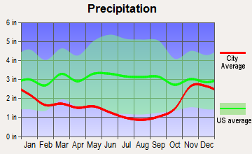
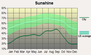
Average climate in Port Townsend, Washington
Based on data reported by over 4,000 weather stations


|
|


(lower is better)
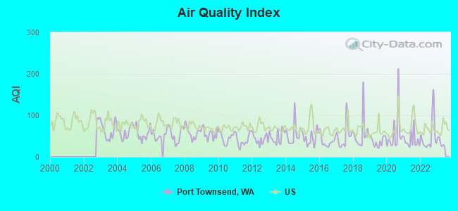
Air Quality Index (AQI) level in 2022 was 50.1. This is significantly better than average.
| City: | 50.1 |
| U.S.: | 72.6 |
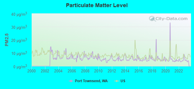
Particulate Matter (PM2.5) [µg/m3] level in 2022 was 4.92. This is significantly better than average. Closest monitor was 0.9 miles away from the city center.
| City: | 4.92 |
| U.S.: | 8.11 |
Earthquake activity:
Port Townsend-area historical earthquake activity is significantly above Washington state average. It is 1141% greater than the overall U.S. average.On 4/13/1949 at 19:55:42, a magnitude 7.0 (7.0 UK, Class: Major, Intensity: VIII - XII) earthquake occurred 61.3 miles away from the city center, causing $80,000,000 total damage
On 2/28/2001 at 18:54:32, a magnitude 6.8 (6.8 MD, Depth: 32.2 mi, Class: Strong, Intensity: VII - IX) earthquake occurred 67.0 miles away from the city center
On 2/28/2001 at 18:54:32, a magnitude 6.8 (6.5 MB, 6.6 MS, 6.8 MW) earthquake occurred 71.6 miles away from the city center, causing $2,000,000,000 total damage and $305,000,000 insured losses
On 4/29/1965 at 15:28:43, a magnitude 6.6 (6.6 UK) earthquake occurred 59.0 miles away from Port Townsend center, causing $28,000,000 total damage
On 7/3/1999 at 01:43:54, a magnitude 5.8 (5.4 MB, 5.5 MS, 5.8 MW, 5.3 ME, Depth: 25.2 mi, Class: Moderate, Intensity: VI - VII) earthquake occurred 76.1 miles away from the city center
On 5/3/1996 at 04:04:22, a magnitude 5.5 (5.2 MB, 5.3 MD, 5.5 ML, Depth: 2.5 mi) earthquake occurred 51.5 miles away from Port Townsend center
Magnitude types: body-wave magnitude (MB), duration magnitude (MD), energy magnitude (ME), local magnitude (ML), surface-wave magnitude (MS), moment magnitude (MW)
Natural disasters:
The number of natural disasters in Jefferson County (21) is greater than the US average (15).Major Disasters (Presidential) Declared: 19
Emergencies Declared: 1
Causes of natural disasters: Floods: 14, Storms: 12, Mudslides: 9, Landslides: 8, Winds: 5, Winter Storms: 5, Tornadoes: 2, Earthquake: 1, Hurricane: 1, Snow: 1, Volcanic Eruption: 1, Other: 1 (Note: some incidents may be assigned to more than one category).

Hospitals and medical centers in Port Townsend:
- JEFFERSON HEALTHCARE HOSPITAL (Government - Hospital District or Authority, provides emergency services, 834 SHERIDAN STREET)
- LIFE CARE CENTER OF PORT TOWNSEND (751 KEARNEY STREET)
- OLYMPIC PENINSULA KIDNEY CENTER NORTHWEST (2500 SIMS WAY STE 102)
- JEFFERSON HEALTHCARE HOME HEALTH (2500 WEST SIMS WAY, SUITE 300)
Airports and heliports located in Port Townsend:
- Jefferson County International Airport (0S9) (Runways: 1, Air Taxi Ops: 1,500, Itinerant Ops: 34,800, Local Ops: 21,700, Military Ops: 100)
- Sky Valley Airstrip Airport (WA68) (Runways: 1)
- Stacey's Airport (WA42) (Runways: 1)
- Jefferson General Hospital Heliport (7WA2)
Colleges/universities with over 2000 students nearest to Port Townsend:
- Everett Community College (about 28 miles; Everett, WA; Full-time enrollment: 5,818)
- Edmonds Community College (about 30 miles; Lynnwood, WA; FT enrollment: 7,271)
- Peninsula College (about 30 miles; Port Angeles, WA; FT enrollment: 2,012)
- Skagit Valley College (about 31 miles; Mount Vernon, WA; FT enrollment: 3,803)
- Shoreline Community College (about 32 miles; Shoreline, WA; FT enrollment: 5,026)
- Seattle Community College-North Campus (about 36 miles; Seattle, WA; FT enrollment: 4,220)
- University of Washington-Bothell Campus (about 37 miles; Bothell, WA; FT enrollment: 3,902)
Public elementary/middle school in Port Townsend:
- CHIMACUM CREEK PRIMARY SCHOOL (Location: 313 NESS CORNER RD, Grades: KG-2)
Private elementary/middle schools in Port Townsend:
User-submitted facts and corrections:
- Your \"normal climate\" information is not accurate. For example, you report that the average snowfall for Port Tosnsend in April is 0.2 in. I have lived here for 24 years and am yet to see a snowflake in April. The data for rainfall is also inaccurate (average rainfall here is about 18.2 in not 19.6.)
Weather conditions vary considerably from place to place here, and I suspect your weather/climate data comes from somewhere else. While the temperature dta is reasonably accurate, the precipitation data is not.
Perhaps site visitors should get some explanation of this disparity.
Points of interest:
Notable locations in Port Townsend: Point Hudson Lighthouse (A), Haines Place Park and Ride (B), Port Townsend Golf Course (C), Jefferson County Fairgrounds (D), Port Townsend Sewage Treatment Plant (E), Sheridan Plaza (F), Kah Tai Care Center (G), Jefferson County Fire Protection District 1 East Jefferson Fire - Rescue Station 1 - 6 (H), Port Townsend City Hall (I), Jefferson County Courthouse (J), Coast Artillery Museum (K), Northwest Maritime Center (L), Rothschild House Historic Home Museum (M), Jefferson County Historical Society (N), Port Townsend Public Library (O). Display/hide their locations on the map
Churches in Port Townsend include: Port Townsend Evangelical Church (A), First Presbyterian Church (B), Port Townsend Friends Meetinghouse (C), Port Townsend Adventist Church (D), Unity Church of Port Townsend (E), Grace Lutheran Church (F), Saint Herman of Alaska Eastern Orthodox Church (G), First Baptist Church (H), Quimper Unitarian Universalist Fellowship Church (I). Display/hide their locations on the map
Cemetery: Laurel Grove Cemetery (1). Display/hide its location on the map
Reservoir: Morgan Hill Reservoir (A). Display/hide its location on the map
Parks in Port Townsend include: Sather Park (1), Chetzemolka Park (2). Display/hide their locations on the map
Tourist attractions: Jefferson County Historical Society Research Center (Museums; 13692 Airport Cutoff Road), Jefferson County Historical Society & Museum (540 Water Street), Port Townsend Marine Science Center (Cultural Attractions- Events- & Facilities; 200 Battery Way), Captain Jack's Sea Charters (Tours & Charters; 118 Taylor Street).
Hotels: Bishop Victorian Hotel (714 Washington Street), Inn at Port Hadlock & Marina (310 Hadlock Bay Road), Blue Gull Inn Bed & Breakfast (1310 Clay Street), Belmont (925 Water Street), Aladdin Motor Inn (2333 Washington Street), Palace Hotel (1004 Water Street), Annapurna Inn & Spa (538 Adams Street), Old Consulate Inn Hastings House (313 Walker Street), Manresa Castle (7th & Sheridan).
Courts: Jefferson County - District Court- Passports (Courthouse), Jefferson County - County Clerk- Superior Court (Courthouse).
Birthplace of: Art McLarney - Professional baseball player, Anita L. Allen - Lawyer, Marvin Glenn Shields - Navy Medal of Honor recipient, Alan James - Film director, Parker Lundgren - Son of Julie Clouse and Scott Lundgren., Tom Baker (1960s pitcher) - Baseball player, Wayne Bastrup - Actor.
Drinking water stations with addresses in Port Townsend and their reported violations in the past:
DABOB COVE COMMUNITY (Population served: 36, Groundwater):Past health violations:Past monitoring violations:
- MCL, Monthly (TCR) - In NOV-2006, Contaminant: Coliform
- MCL, Monthly (TCR) - In SEP-2005, Contaminant: Coliform
- 939 regular monitoring violations
Drinking water stations with addresses in Port Townsend that have no violations reported:
- CAPE GEORGE COLONY CLUB INC (Population served: 1,010, Primary Water Source Type: Groundwater)
| This city: | 2.0 people |
| Washington: | 2.5 people |
| This city: | 51.1% |
| Whole state: | 64.4% |
| This city: | 8.0% |
| Whole state: | 7.7% |
Likely homosexual households (counted as self-reported same-sex unmarried-partner households)
- Lesbian couples: 0.9% of all households
- Gay men: 0.3% of all households
People in group quarters in Port Townsend in 2010:
- 87 people in nursing facilities/skilled-nursing facilities
- 10 people in emergency and transitional shelters (with sleeping facilities) for people experiencing homelessness
- 10 people in other noninstitutional facilities
- 7 people in group homes intended for adults
People in group quarters in Port Townsend in 2000:
- 93 people in other noninstitutional group quarters
- 23 people in homes for the mentally retarded
- 10 people in nursing homes
- 2 people in other nonhousehold living situations
Banks with branches in Port Townsend (2011 data):
- Wells Fargo Bank, National Association: Port Townsend Branch at 2101 Washington Street, branch established on 1956/04/05. Info updated 2011/04/05: Bank assets: $1,161,490.0 mil, Deposits: $905,653.0 mil, headquarters in Sioux Falls, SD, positive income, 6395 total offices, Holding Company: Wells Fargo & Company
- U.S. Bank National Association: Port Townsend Branch at 1239 Water Street, branch established on 1975/01/06. Info updated 2012/01/30: Bank assets: $330,470.8 mil, Deposits: $236,091.5 mil, headquarters in Cincinnati, OH, positive income, 3121 total offices, Holding Company: U.S. Bancorp
- Bank of America, National Association: Port Townsend Branch at 734 Water Street, branch established on 1929/09/01. Info updated 2009/11/18: Bank assets: $1,451,969.3 mil, Deposits: $1,077,176.8 mil, headquarters in Charlotte, NC, positive income, 5782 total offices, Holding Company: Bank Of America Corporation
- Columbia State Bank: Port Townsend Branch at 442 W. Sims Way, branch established on 2005/03/31. Info updated 2011/08/09: Bank assets: $4,785.2 mil, Deposits: $3,892.8 mil, headquarters in Tacoma, WA, positive income, Commercial Lending Specialization, 104 total offices, Holding Company: Columbia Banking System, Inc.
- JPMorgan Chase Bank, National Association: Port Townsend at 419 Kearney St, branch established on 1916/01/01. Info updated 2011/11/10: Bank assets: $1,811,678.0 mil, Deposits: $1,190,738.0 mil, headquarters in Columbus, OH, positive income, International Specialization, 5577 total offices, Holding Company: Jpmorgan Chase & Co.
- Kitsap Bank: Port Townsend Branch at 2313 East Sims Way, branch established on 2002/12/16. Info updated 2009/05/11: Bank assets: $903.9 mil, Deposits: $775.3 mil, headquarters in Port Orchard, WA, positive income, Commercial Lending Specialization, 22 total offices, Holding Company: Olympic Bancorp, Inc.
- First Federal Savings and Loan Association of Port Angeles: Port Townsend Branch at 1321 Sims Way, branch established on 1989/11/30. Info updated 2012/01/18: Bank assets: $764.3 mil, Deposits: $581.6 mil, headquarters in Port Angeles, WA, positive income, Mortgage Lending Specialization, 8 total offices
- Union Bank, National Association: Port Townsend Branch at 2200 W Sims Way, branch established on 1993/01/20. Info updated 2011/09/01: Bank assets: $88,967.5 mil, Deposits: $65,286.4 mil, headquarters in San Francisco, CA, positive income, Commercial Lending Specialization, 403 total offices, Holding Company: Mitsubishi Ufj Financial Group, Inc.
For population 15 years and over in Port Townsend:
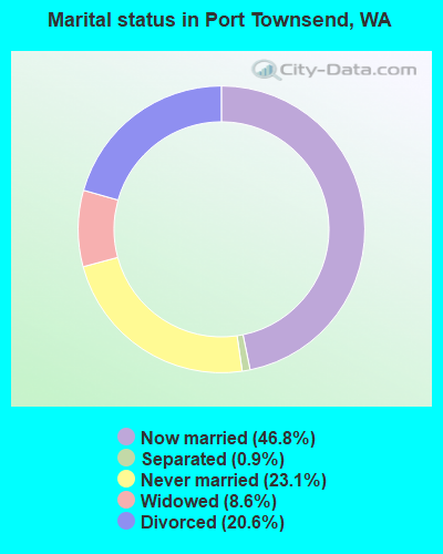
- Never married: 23.1%
- Now married: 46.8%
- Separated: 0.9%
- Widowed: 8.6%
- Divorced: 20.6%
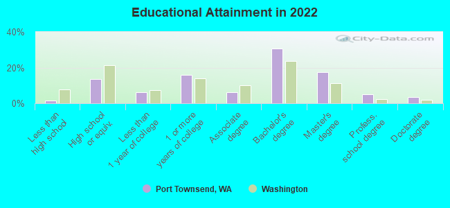
For population 25 years and over in Port Townsend:
- High school or higher: 98.5%
- Bachelor's degree or higher: 54.7%
- Graduate or professional degree: 24.6%
- Unemployed: 7.2%
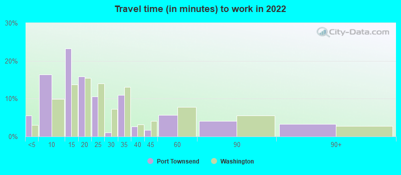
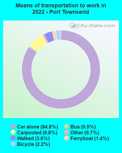
- Mean travel time to work (commute): 18.3 minutes
| Here: | 9.8 |
| Washington average: | 11.6 |
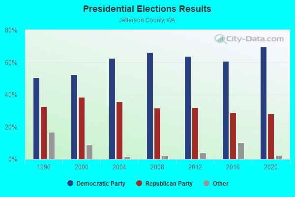
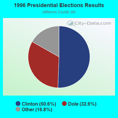
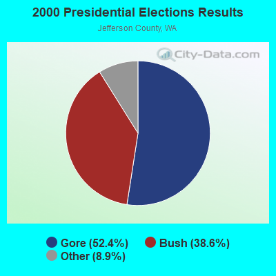
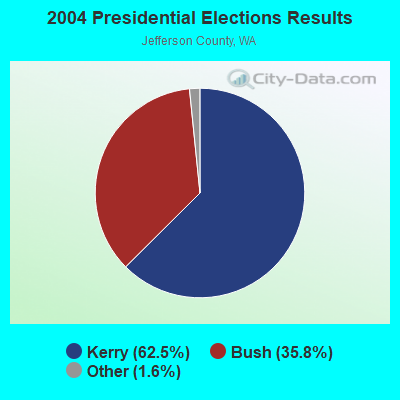
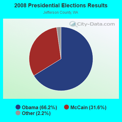
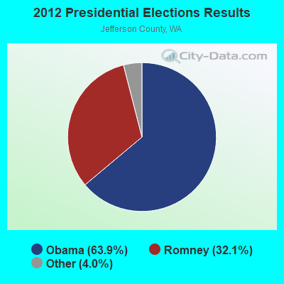
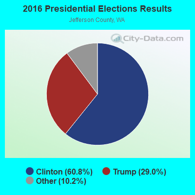
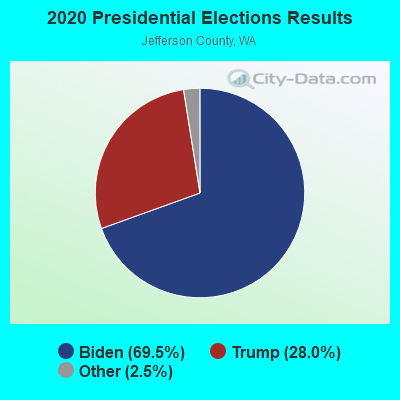
Graphs represent county-level data. Detailed 2008 Election Results
Religion statistics for Port Townsend, WA (based on Jefferson County data)
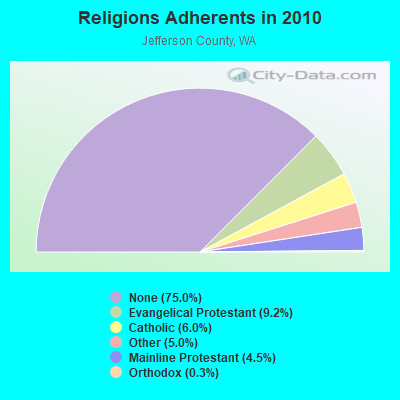
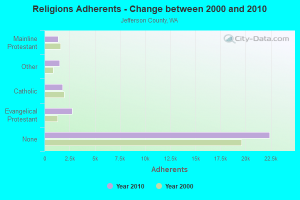
| Religion | Adherents | Congregations |
|---|---|---|
| Evangelical Protestant | 2,747 | 19 |
| Catholic | 1,786 | 1 |
| Other | 1,490 | 12 |
| Mainline Protestant | 1,351 | 9 |
| Orthodox | 100 | 1 |
| None | 22,398 | - |
Food Environment Statistics:
| Jefferson County: | 2.74 / 10,000 pop. |
| Washington: | 2.06 / 10,000 pop. |
| This county: | 1.37 / 10,000 pop. |
| Washington: | 1.18 / 10,000 pop. |
| Here: | 3.09 / 10,000 pop. |
| Washington: | 2.67 / 10,000 pop. |
| This county: | 15.43 / 10,000 pop. |
| Washington: | 8.26 / 10,000 pop. |
| This county: | 6.9% |
| Washington: | 7.7% |
| Here: | 20.8% |
| State: | 25.7% |
| Jefferson County: | 15.2% |
| Washington: | 13.9% |
Health and Nutrition:
| Port Townsend: | 53.8% |
| State: | 49.9% |
| This city: | 52.4% |
| Washington: | 47.2% |
| This city: | 28.8 |
| Washington: | 28.4 |
| This city: | 18.7% |
| State: | 20.9% |
| Port Townsend: | 10.3% |
| Washington: | 10.5% |
| Here: | 6.9 |
| State: | 6.8 |
| Port Townsend: | 37.5% |
| Washington: | 32.8% |
| Port Townsend: | 58.4% |
| Washington: | 56.8% |
| This city: | 77.3% |
| Washington: | 79.4% |
More about Health and Nutrition of Port Townsend, WA Residents
| Local government employment and payroll (March 2022) | |||||
| Function | Full-time employees | Monthly full-time payroll | Average yearly full-time wage | Part-time employees | Monthly part-time payroll |
|---|---|---|---|---|---|
| Other Government Administration | 12 | $46,567 | $46,567 | 8 | $9,719 |
| Other and Unallocable | 11 | $77,460 | $84,502 | 0 | $0 |
| Financial Administration | 9 | $58,948 | $78,597 | 0 | $0 |
| Police Protection - Officers | 9 | $43,791 | $58,388 | 1 | $1,368 |
| Water Supply | 9 | $59,516 | $79,355 | 0 | $0 |
| Streets and Highways | 5 | $28,390 | $68,136 | 0 | $0 |
| Parks and Recreation | 4 | $24,026 | $72,078 | 0 | $0 |
| Sewerage | 4 | $26,732 | $80,196 | 0 | $0 |
| Solid Waste Management | 4 | $25,336 | $76,008 | 0 | $0 |
| Local Libraries | 3 | $17,616 | $70,464 | 10 | $13,742 |
| Police - Other | 3 | $23,590 | $94,360 | 0 | $0 |
| Judicial and Legal | 1 | $11,426 | $137,112 | 1 | $2,512 |
| Totals for Government | 74 | $443,398 | $71,902 | 20 | $27,341 |
Port Townsend government finances - Expenditure in 2017 (per resident):
- Construction - Regular Highways: $971,000 ($93.47)
General - Other: $99,000 ($9.53)
- Current Operations - Police Protection: $2,324,000 ($223.72)
Sewerage: $1,655,000 ($159.32)
Water Utilities: $1,374,000 ($132.27)
Parks and Recreation: $1,131,000 ($108.88)
General - Other: $1,052,000 ($101.27)
Central Staff Services: $1,014,000 ($97.61)
Libraries: $940,000 ($90.49)
General Public Buildings: $722,000 ($69.50)
Regular Highways: $519,000 ($49.96)
Financial Administration: $407,000 ($39.18)
Judicial and Legal Services: $240,000 ($23.10)
Correctional Institutions: $97,000 ($9.34)
Local Fire Protection: $19,000 ($1.83)
Natural Resources - Other: $17,000 ($1.64)
Housing and Community Development: $11,000 ($1.06)
- General - Interest on Debt: $817,000 ($78.65)
- Intergovernmental to Local - Other - Local Fire Protection: $2,230,000 ($214.67)
Other - Correctional Institutions: $541,000 ($52.08)
Other - Judicial and Legal Services: $137,000 ($13.19)
Other - Water Utilities: $110,000 ($10.59)
Other - Sewerage: $45,000 ($4.33)
Other - Central Staff Services: $28,000 ($2.70)
Other - Financial Administration: $18,000 ($1.73)
Other - General - Other: $11,000 ($1.06)
- Other Capital Outlay - Water Utilities: $13,475,000 ($1297.17)
General - Other: $839,000 ($80.77)
Sewerage: $290,000 ($27.92)
Libraries: $75,000 ($7.22)
Financial Administration: $67,000 ($6.45)
Parks and Recreation: $62,000 ($5.97)
Natural Resources - Other: $51,000 ($4.91)
Police Protection: $30,000 ($2.89)
Regular Highways: $20,000 ($1.93)
Central Staff Services: $2,000 ($0.19)
- Total Salaries and Wages: $6,705,000 ($645.46)
- Water Utilities - Interest on Debt: $40,000 ($3.85)
Port Townsend government finances - Revenue in 2017 (per resident):
- Charges - Miscellaneous Commercial Activities: $2,377,000 ($228.82)
Sewerage: $1,064,000 ($102.43)
Other: $208,000 ($20.02)
Parks and Recreation: $127,000 ($12.23)
Solid Waste Management: $5,000 ($0.48)
- Federal Intergovernmental - Other: $1,000 ($0.10)
- Miscellaneous - Rents: $147,000 ($14.15)
Fines and Forfeits: $61,000 ($5.87)
General Revenue - Other: $39,000 ($3.75)
Donations From Private Sources: $35,000 ($3.37)
Interest Earnings: $0 ($0.00)
- Revenue - Water Utilities: $3,681,000 ($354.35)
- State Intergovernmental - Highways: $711,000 ($68.44)
Other: $449,000 ($43.22)
General Local Government Support: $125,000 ($12.03)
Housing and Community Development: $17,000 ($1.64)
- Tax - Property: $4,633,000 ($446.00)
General Sales and Gross Receipts: $2,996,000 ($288.41)
Public Utilities Sales: $2,553,000 ($245.76)
Occupation and Business License - Other: $917,000 ($88.27)
Other Selective Sales: $596,000 ($57.37)
Documentary and Stock Transfer: $590,000 ($56.80)
Other License: $372,000 ($35.81)
Port Townsend government finances - Debt in 2017 (per resident):
- Long Term Debt - Outstanding Unspecified Public Purpose: $43,900,000 ($4226.03)
Beginning Outstanding - Unspecified Public Purpose: $29,921,000 ($2880.34)
Issue, Unspecified Public Purpose: $16,061,000 ($1546.11)
Retired Unspecified Public Purpose: $2,082,000 ($200.42)
| Businesses in Port Townsend, WA | ||||
| Name | Count | Name | Count | |
|---|---|---|---|---|
| DHL | 1 | Nike | 2 | |
| FedEx | 2 | RadioShack | 1 | |
| H&R Block | 1 | Starbucks | 1 | |
| Kroger | 1 | Subway | 1 | |
| La-Z-Boy | 1 | UPS | 5 | |
| MasterBrand Cabinets | 1 | Vons | 2 | |
| McDonald's | 1 | YMCA | 1 | |
| New Balance | 1 | |||
Strongest AM radio stations in Port Townsend:
- KKOL (1300 AM; 50 kW; SEATTLE, WA; Owner: INSPIRATION MEDIA, INC.)
- KRKO (1380 AM; 50 kW; EVERETT, WA; Owner: S-R BROADCASTING, CO.)
- KIXI (880 AM; 50 kW; MERCER ISLAND/SEATTL, WA; Owner: BELLEVUE RADIO, INC.)
- KIRO (710 AM; 50 kW; SEATTLE, WA; Owner: ENTERCOM SEATTLE LICENSE, LLC)
- KGNW (820 AM; 50 kW; BURIEN-SEATTLE, WA; Owner: INSPIRATION MEDIA, INC.)
- KTTH (770 AM; 50 kW; SEATTLE, WA; Owner: ENTERCOM SEATTLE LICENSE, LLC)
- KOMO (1000 AM; 50 kW; SEATTLE, WA; Owner: FISHER BROADCASTING - SEATTLE RADIO, L.L.C.)
- KYCW (1090 AM; 50 kW; SEATTLE, WA; Owner: INFINITY RADIO SUBSIDIARY OPERATIONS INC.)
- KAPS (660 AM; 10 kW; MOUNT VERNON, WA; Owner: VALLEY BROADCASTERS, INC.)
- KJR (950 AM; 50 kW; SEATTLE, WA)
- KRPI (1550 AM; 50 kW; FERNDALE, WA; Owner: BBC BROADCASTING, INC.)
- KARI (550 AM; 25 kW; BLAINE, WA; Owner: WAY BROADCASTING, INC.)
- KCIS (630 AM; 5 kW; EDMONDS, WA; Owner: CRISTA MINISTRIES)
Strongest FM radio stations in Port Townsend:
- KISW (99.9 FM; SEATTLE, WA; Owner: ENTERCOM SEATTLE LICENSE, LLC)
- KISM (92.9 FM; BELLINGHAM, WA; Owner: SAGA BROADCASTING, LLC)
- KQBZ (100.7 FM; SEATTLE, WA; Owner: ENTERCOM SEATTLE LICENSE, LLC)
- KWPZ (106.5 FM; LYNDEN, WA; Owner: CRISTA MINISTRIES, INC.)
- KAFE (104.3 FM; BELLINGHAM, WA; Owner: SAGA BROADCASTING, LLC)
- K206CU (89.1 FM; MOUNT VERNON, WA; Owner: CALVARY CHAPEL OF TWIN FALLS, INC.)
- KSVR (91.7 FM; MOUNT VERNON, WA; Owner: BOARD OF TRUSTEES OF SKAGIT VALLEY COLLEGE)
- KCMS (105.3 FM; EDMONDS, WA; Owner: CRISTA MINISTRIES, INC.)
- KMTT (103.7 FM; TACOMA, WA; Owner: ENTERCOM SEATTLE LICENSE, LLC)
- KNDD (107.7 FM; SEATTLE, WA; Owner: ENTERCOM SEATTLE LICENSE, LLC)
- KYPT (96.5 FM; SEATTLE, WA; Owner: INFINITY RADIO SUBSIDIARY OPERATIONS INC.)
- KBSG-FM (97.3 FM; TACOMA, WA; Owner: ENTERCOM SEATTLE LICENSE, LLC)
- KBKS (106.1 FM; TACOMA, WA; Owner: INFINITY RADIO SUBSIDIARY OPERATIONS INC.)
- KING-FM (98.1 FM; SEATTLE, WA; Owner: CLASSIC RADIO, INC.)
- KLSY-FM (92.5 FM; BELLEVUE, WA; Owner: BELLEVUE RADIO INC.)
- KPLU-FM (88.5 FM; TACOMA, WA; Owner: PACIFIC LUTHERAN UNIVERSITY, INC.)
- KWJZ (98.9 FM; SEATTLE, WA; Owner: ORCA RADIO, INC.)
- KZOK-FM (102.5 FM; SEATTLE, WA; Owner: INFINITY RADIO SUBSIDIARY OPERATIONS INC.)
- KMPS-FM (94.1 FM; SEATTLE, WA; Owner: INFINITY RADIO SUBSIDIARY OPERATIONS INC.)
- K205DD (88.9 FM; BREMERTON, WA; Owner: CALVARY CHAPEL OF TWIN FALLS, INC.)
TV broadcast stations around Port Townsend:
- KING-TV (Channel 5; SEATTLE, WA; Owner: KING BROADCASTING COMPANY)
- KSTW (Channel 11; TACOMA, WA; Owner: UPN TELEVISION STATIONS INC.)
- KCPQ (Channel 13; TACOMA, WA; Owner: TRIBUNE TELEVISION NORTHWEST, INC.)
- K58DP (Channel 58; SEATTLE, WA; Owner: WORD OF GOD FELLOWSHIP, INC.)
- KOMO-TV (Channel 4; SEATTLE, WA; Owner: FISHER BROADCASTING - SEATTLE TV, L.L.C.)
- KTWB-TV (Channel 22; SEATTLE, WA; Owner: TRIBUNE TELEVISION HOLDINGS, INC.)
Medal of Honor Recipients
Medal of Honor Recipient born in Port Townsend: Marvin G. Shields.
- National Bridge Inventory (NBI) Statistics
- 4Number of bridges
- 75ft / 23.4mTotal length
- $12,913,000Total costs
- 21,708Total average daily traffic
- 1,152Total average daily truck traffic
- 29,684Total future (year 2033) average daily traffic
FCC Registered Antenna Towers: 85 (See the full list of FCC Registered Antenna Towers)
FCC Registered Private Land Mobile Towers: 2 (See the full list of FCC Registered Private Land Mobile Towers in Port Townsend, WA)
FCC Registered Broadcast Land Mobile Towers: 22 (See the full list of FCC Registered Broadcast Land Mobile Towers)
FCC Registered Microwave Towers: 33 (See the full list of FCC Registered Microwave Towers in this town)
FCC Registered Paging Towers: 5 (See the full list of FCC Registered Paging Towers)
FCC Registered Maritime Coast & Aviation Ground Towers: 12 (See the full list of FCC Registered Maritime Coast & Aviation Ground Towers)
FCC Registered Amateur Radio Licenses: 535 (See the full list of FCC Registered Amateur Radio Licenses in Port Townsend)
FAA Registered Aircraft Manufacturers and Dealers: 1 (See the full list of FAA Registered Manufacturers and Dealers in Port Townsend)
FAA Registered Aircraft: 124 (See the full list of FAA Registered Aircraft)
2002 - 2018 National Fire Incident Reporting System (NFIRS) incidents
- Fire incident types reported to NFIRS in Port Townsend, WA
- 73555.3%Structure Fires
- 34425.9%Outside Fires
- 18614.0%Mobile Property/Vehicle Fires
- 634.7%Other
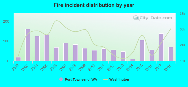 According to the data from the years 2002 - 2018 the average number of fires per year is 78. The highest number of reported fires - 159 took place in 2003, and the least - 9 in 2014. The data has a growing trend.
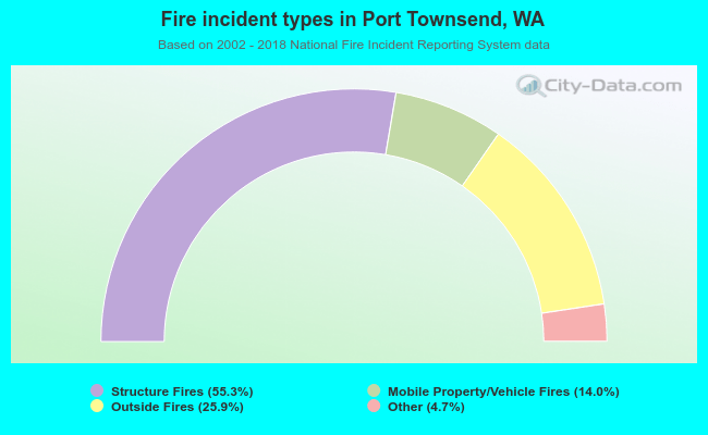 When looking into fire subcategories, the most reports belonged to: Structure Fires (55.3%), and Outside Fires (25.9%).
| Most common first names in Port Townsend, WA among deceased individuals | ||
| Name | Count | Lived (average) |
|---|---|---|
| John | 112 | 74.1 years |
| Robert | 98 | 75.1 years |
| William | 86 | 76.2 years |
| Mary | 68 | 80.9 years |
| James | 63 | 75.9 years |
| George | 56 | 78.6 years |
| Charles | 55 | 73.5 years |
| Helen | 52 | 82.1 years |
| Margaret | 50 | 80.3 years |
| Dorothy | 42 | 81.9 years |
| Most common last names in Port Townsend, WA among deceased individuals | ||
| Last name | Count | Lived (average) |
|---|---|---|
| Johnson | 48 | 79.7 years |
| Smith | 46 | 78.3 years |
| Anderson | 30 | 80.4 years |
| Brown | 27 | 79.6 years |
| Miller | 25 | 80.3 years |
| Taylor | 16 | 66.7 years |
| Martin | 16 | 79.8 years |
| Jones | 15 | 76.9 years |
| Peterson | 15 | 77.7 years |
| Deleo | 12 | 80.7 years |
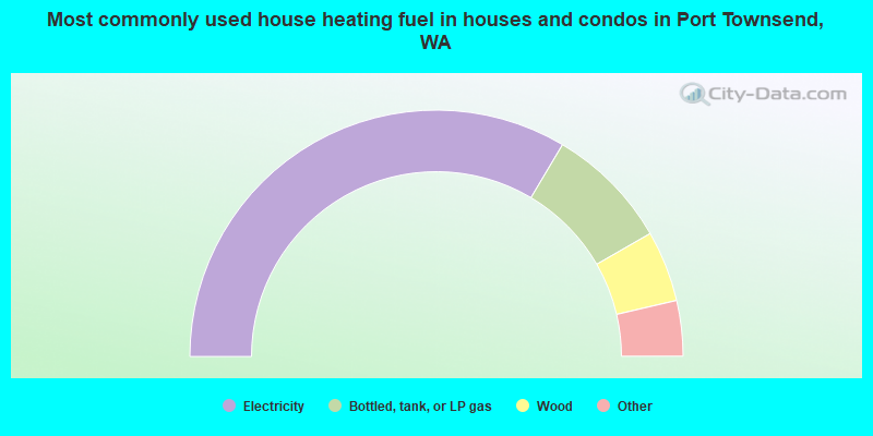
- 67.1%Electricity
- 16.3%Bottled, tank, or LP gas
- 9.3%Wood
- 3.1%Fuel oil, kerosene, etc.
- 1.6%Solar energy
- 1.3%Other fuel
- 1.3%Utility gas
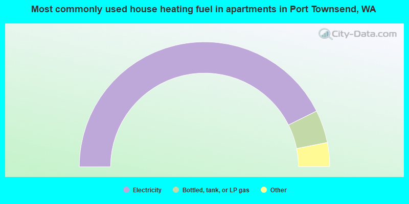
- 85.3%Electricity
- 8.5%Bottled, tank, or LP gas
- 2.0%Wood
- 1.2%No fuel used
- 1.2%Utility gas
- 0.9%Fuel oil, kerosene, etc.
- 0.9%Other fuel
Port Townsend compared to Washington state average:
- Median household income below state average.
- Unemployed percentage below state average.
- Black race population percentage significantly below state average.
- Hispanic race population percentage significantly below state average.
- Median age significantly above state average.
- Foreign-born population percentage significantly below state average.
- Length of stay since moving in significantly above state average.
- Number of college students below state average.
- Percentage of population with a bachelor's degree or higher above state average.
Port Townsend on our top lists:
- #48 on the list of "Top 101 cities with the largest percentage of divorced people (15+ years)(population 5,000+)"
- #59 on the list of "Top 101 cities with largest percentage of females in industries: other services, except public administration (population 5,000+)"
- #66 on the list of "Top 101 cities with the highest number of arson incidents per 100,000 residents, excludes tourist destinations and others with a lot of outsiders visiting based on city industries data (population 5,000+)"
- #75 on the list of "Top 101 cities with largest percentage of females in industries: information (population 5,000+)"
- #80 on the list of "Top 101 cities with the highest percentage of workers working at home, population 5,000+"

|
|
Total of 121 patent applications in 2008-2024.