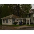
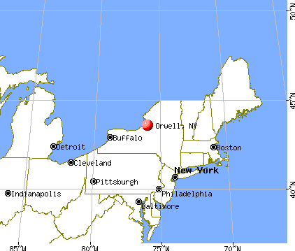
Orwell, New York
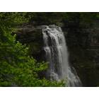
Orwell: Salmon River Falls, Orwell New York
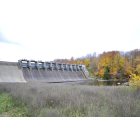
Orwell: The Dam on the upper Res.
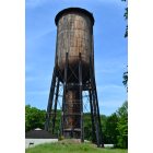
Orwell: Wooden Water Tower @ Bennett Bridge
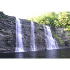
Orwell: The Salmon River Falls

Orwell: Sunset on Jackson Road
Orwell: Salmon River Falls, Orwell New York
- add
your
Submit your own pictures of this town and show them to the world
- OSM Map
- General Map
- Google Map
- MSN Map
Population change since 2000: -6.9%
 |
| Males: 630 | |
| Females: 537 |
| Median resident age: | 43.1 years |
| New York median age: | 40.7 years |
Zip codes: 13144.
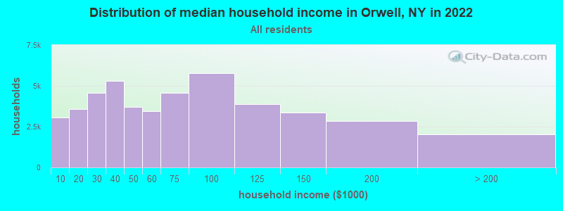
| Orwell: | $56,409 |
| NY: | $79,557 |
Estimated per capita income in 2022: $29,752 (it was $15,256 in 2000)
Orwell town income, earnings, and wages data
Estimated median house or condo value in 2022: $116,767 (it was $58,300 in 2000)
| Orwell: | $116,767 |
| NY: | $400,400 |
Mean prices in 2022: all housing units: $171,234; detached houses: $187,738; townhouses or other attached units: $467,987; in 2-unit structures: $241,662; in 3-to-4-unit structures: $129,857; in 5-or-more-unit structures: $423,366; mobile homes: $64,434; occupied boats, rvs, vans, etc.: $95,273
Detailed information about poverty and poor residents in Orwell, NY


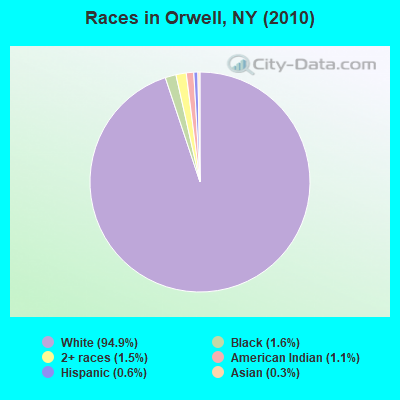
- 1,10894.9%White alone
- 191.6%Black alone
- 171.5%Two or more races
- 131.1%American Indian alone
- 70.6%Hispanic
- 30.3%Asian alone
Races in Orwell detailed stats: ancestries, foreign born residents, place of birth
 Recent articles from our blog. Our writers, many of them Ph.D. graduates or candidates, create easy-to-read articles on a wide variety of topics.


Latest news from Orwell, NY collected exclusively by city-data.com from local newspapers, TV, and radio stations
Ancestries: German (18.0%), English (15.2%), Irish (11.5%), United States (6.9%), Italian (6.7%), French (6.5%).
Current Local Time: EST time zone
Elevation: 808 feet
Land area: 39.8 square miles.
Population density: 29 people per square mile (very low).
15 residents are foreign born
| This town: | 1.2% |
| New York: | 20.4% |
| Orwell town: | 1.5% ($874) |
| New York: | 1.9% ($2,847) |
Nearest city with pop. 50,000+: Clay, NY  (30.7 miles , pop. 58,805).
Nearest city with pop. 200,000+: Rochester, NY (87.8 miles , pop. 219,773).
Nearest city with pop. 1,000,000+: Bronx, NY (215.6 miles , pop. 1,332,650).
Nearest cities:
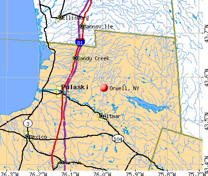
), ), ), Latitude: 43.56 N, Longitude: 75.95 W
Area code commonly used in this area: 315

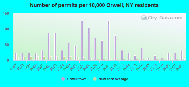
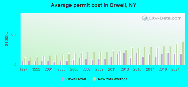
Single-family new house construction building permits:
- 2022: 4 buildings, average cost: $192,000
- 2021: 3 buildings, average cost: $188,000
- 2020: 3 buildings, average cost: $206,600
- 2019: 1 building, cost: $187,000
- 2018: 2 buildings, average cost: $144,000
- 2017: 1 building, cost: $174,000
- 2016: 5 buildings, average cost: $137,600
- 2015: 2 buildings, average cost: $198,000
- 2014: 3 buildings, average cost: $123,300
- 2013: 4 buildings, average cost: $197,000
- 2012: 10 buildings, average cost: $179,600
- 2011: 16 buildings, average cost: $131,800
- 2010: 8 buildings, average cost: $102,100
- 2009: 9 buildings, average cost: $102,800
- 2008: 13 buildings, average cost: $87,900
- 2007: 16 buildings, average cost: $104,400
- 2006: 6 buildings, average cost: $116,900
- 2005: 7 buildings, average cost: $89,800
- 2004: 4 buildings, average cost: $74,700
- 2003: 11 buildings, average cost: $67,000
- 2002: 11 buildings, average cost: $56,300
- 2001: 4 buildings, average cost: $66,700
- 2000: 3 buildings, average cost: $66,700
- 1999: 3 buildings, average cost: $66,700
- 1998: 3 buildings, average cost: $66,700
- 1997: 3 buildings, average cost: $66,700
| Here: | 5.1% |
| New York: | 4.4% |
- Metal & metal products (9.9%)
- Accommodation & food services (9.3%)
- Construction (8.6%)
- Educational services (8.0%)
- Paper (7.8%)
- Public administration (5.4%)
- Health care (5.4%)
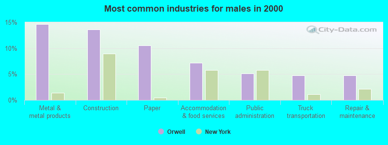
- Metal & metal products (14.6%)
- Construction (13.6%)
- Paper (10.5%)
- Accommodation & food services (7.1%)
- Public administration (5.1%)
- Truck transportation (4.8%)
- Repair & maintenance (4.8%)
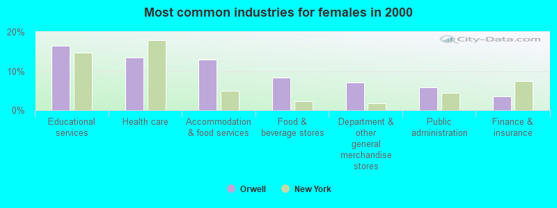
- Educational services (16.5%)
- Health care (13.5%)
- Accommodation & food services (12.9%)
- Food & beverage stores (8.2%)
- Department & other general merchandise stores (7.1%)
- Public administration (5.9%)
- Finance & insurance (3.5%)
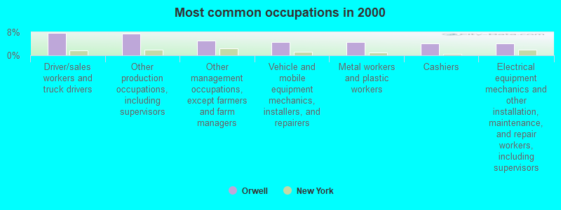
- Driver/sales workers and truck drivers (7.8%)
- Other production occupations, including supervisors (7.5%)
- Other management occupations, except farmers and farm managers (5.2%)
- Vehicle and mobile equipment mechanics, installers, and repairers (4.5%)
- Metal workers and plastic workers (4.5%)
- Cashiers (4.1%)
- Electrical equipment mechanics and other installation, maintenance, and repair workers, including supervisors (4.1%)
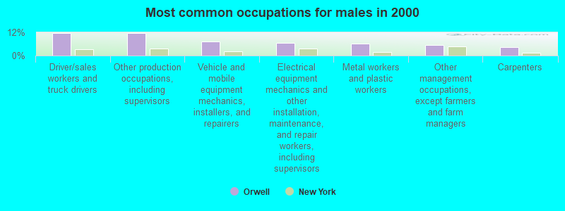
- Driver/sales workers and truck drivers (11.6%)
- Other production occupations, including supervisors (11.6%)
- Vehicle and mobile equipment mechanics, installers, and repairers (7.1%)
- Electrical equipment mechanics and other installation, maintenance, and repair workers, including supervisors (6.5%)
- Metal workers and plastic workers (6.1%)
- Other management occupations, except farmers and farm managers (5.4%)
- Carpenters (4.4%)
- Cashiers (9.4%)
- Preschool, kindergarten, elementary, and middle school teachers (7.1%)
- Health technologists and technicians (7.1%)
- Waiters and waitresses (6.5%)
- Material recording, scheduling, dispatching, and distributing workers (5.3%)
- Other management occupations, except farmers and farm managers (4.7%)
- Secretaries and administrative assistants (4.7%)
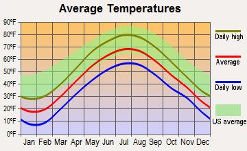
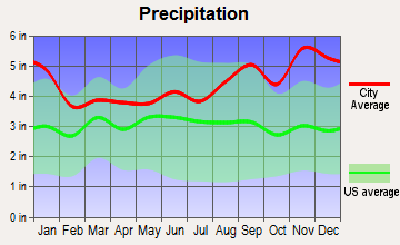
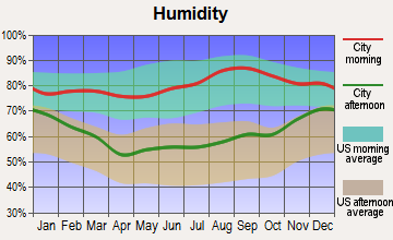
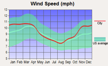
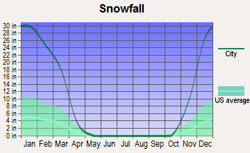
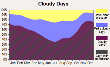
Average climate in Orwell, New York
Based on data reported by over 4,000 weather stations

Earthquake activity:
Orwell-area historical earthquake activity is significantly above New York state average. It is 69% smaller than the overall U.S. average.On 10/7/1983 at 10:18:46, a magnitude 5.3 (5.1 MB, 5.3 LG, 5.1 ML, Class: Moderate, Intensity: VI - VII) earthquake occurred 84.9 miles away from Orwell center
On 4/20/2002 at 10:50:47, a magnitude 5.3 (5.3 ML, Depth: 3.0 mi) earthquake occurred 130.0 miles away from the city center
On 4/20/2002 at 10:50:47, a magnitude 5.2 (5.2 MB, 4.2 MS, 5.2 MW, 5.0 MW) earthquake occurred 128.3 miles away from Orwell center
On 9/25/1998 at 19:52:52, a magnitude 5.2 (4.8 MB, 4.3 MS, 5.2 LG, 4.5 MW, Depth: 3.1 mi) earthquake occurred 267.9 miles away from Orwell center
On 8/23/2011 at 17:51:04, a magnitude 5.8 (5.8 MW, Depth: 3.7 mi) earthquake occurred 404.3 miles away from the city center
On 6/17/1991 at 08:53:16, a magnitude 4.1 (4.0 MB, 4.0 LG, Depth: 3.1 mi, Class: Light, Intensity: IV - V) earthquake occurred 90.9 miles away from Orwell center
Magnitude types: regional Lg-wave magnitude (LG), body-wave magnitude (MB), local magnitude (ML), surface-wave magnitude (MS), moment magnitude (MW)
Natural disasters:
The number of natural disasters in Oswego County (16) is near the US average (15).Major Disasters (Presidential) Declared: 7
Emergencies Declared: 7
Causes of natural disasters: Floods: 6, Storms: 3, Hurricanes: 2, Snows: 2, Winds: 2, Blizzard: 1, Heavy Rain: 1, Ice Storm: 1, Landslide: 1, Power Outage: 1, Tropical Storm: 1, Other: 2 (Note: some incidents may be assigned to more than one category).
Colleges/universities with over 2000 students nearest to Orwell:
- Jefferson Community College (about 30 miles; Watertown, NY; Full-time enrollment: 2,886)
- SUNY College at Oswego (about 31 miles; Oswego, NY; FT enrollment: 7,550)
- Le Moyne College (about 37 miles; Syracuse, NY; FT enrollment: 3,041)
- Syracuse University (about 38 miles; Syracuse, NY; FT enrollment: 20,717)
- SUNY College of Environmental Science and Forestry (about 38 miles; Syracuse, NY; FT enrollment: 2,044)
- Onondaga Community College (about 41 miles; Syracuse, NY; FT enrollment: 8,920)
- Utica College (about 47 miles; Utica, NY; FT enrollment: 2,952)
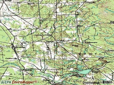
Points of interest:
Notable locations in Orwell: Bennett Ridge (A), Castor Corners (B), Orwell Volunteer Fire Company (C), Cogswell Free Library (D). Display/hide their locations on the map
Churches in Orwell include: Vorea Community Church (A), Greater Victory Fellowship Church (B), Pine Meadows Wesleyan Church (C), Richland Christian Church (D). Display/hide their locations on the map
Cemeteries: Potter Cemetery (1), Gilbert Hill Cemetery (2), Pekin Cemetery (3), Chateaugay Cemetery (4), Evergreen Cemetery (5). Display/hide their locations on the map
Lakes and reservoirs: Jackson Pond (A), Sage Pond (B), Gowdy Pond (C), Lower Reservoir (D), Salmon River Reservoir (E). Display/hide their locations on the map
Streams, rivers, and creeks: Pekin Brook (A), Pennock Brook (B). Display/hide their locations on the map
| This town: | 2.6 people |
| New York: | 2.6 people |
| This town: | 68.5% |
| Whole state: | 63.5% |
| This town: | 11.2% |
| Whole state: | 6.8% |
Likely homosexual households (counted as self-reported same-sex unmarried-partner households)
- Lesbian couples: 0.0% of all households
- Gay men: 0.5% of all households
| This town: | 21.5% |
| Whole state: | 14.6% |
| This town: | 12.3% |
| Whole state: | 7.4% |
3 people in workers' group living quarters and job corps centers in 2010
81 people in homes or halfway houses for drug/alcohol abuse in 2000
6 people in agriculture workers' dormitories on farms in 2000
For population 15 years and over in Orwell:
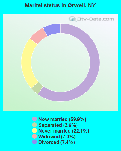
- Never married: 22.1%
- Now married: 59.9%
- Separated: 3.6%
- Widowed: 7.0%
- Divorced: 7.4%
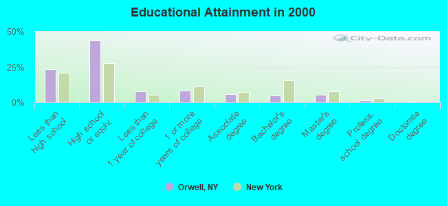
For population 25 years and over in Orwell:
- High school or higher: 76.9%
- Bachelor's degree or higher: 11.8%
- Graduate or professional degree: 6.9%
- Unemployed: 19.6%
- Mean travel time to work (commute): 28.6 minutes
| Here: | 10.1 |
| New York average: | 14.2 |
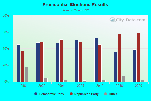
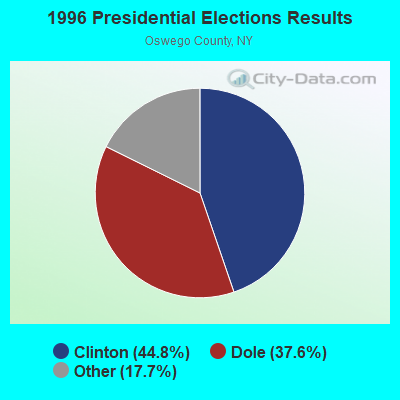
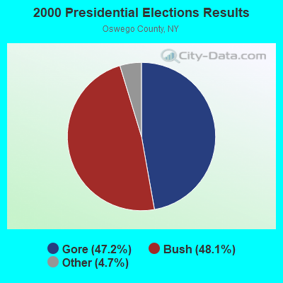
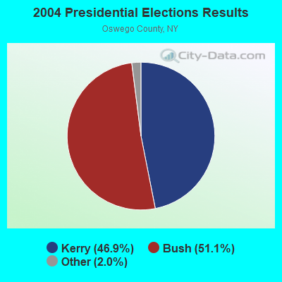
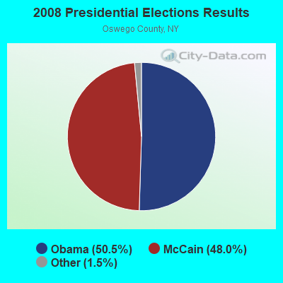
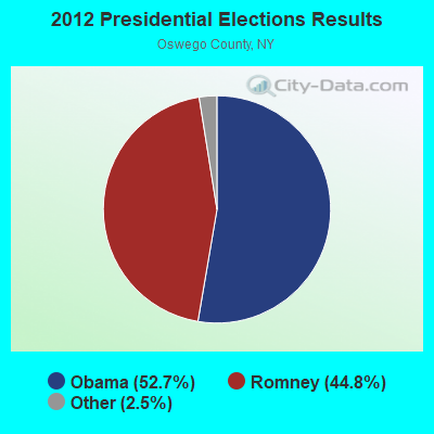
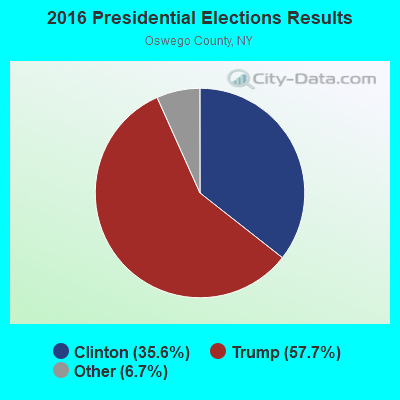
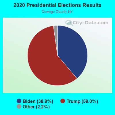
Graphs represent county-level data. Detailed 2008 Election Results
Religion statistics for Orwell, NY (based on Oswego County data)
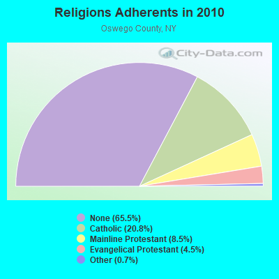
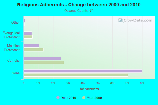
| Religion | Adherents | Congregations |
|---|---|---|
| Catholic | 25,395 | 17 |
| Mainline Protestant | 10,408 | 60 |
| Evangelical Protestant | 5,504 | 53 |
| Other | 860 | 6 |
| None | 79,942 | - |
Food Environment Statistics:
| Here: | 2.06 / 10,000 pop. |
| State: | 4.13 / 10,000 pop. |
| Here: | 0.08 / 10,000 pop. |
| New York: | 0.06 / 10,000 pop. |
| Oswego County: | 0.49 / 10,000 pop. |
| New York: | 0.92 / 10,000 pop. |
| This county: | 4.03 / 10,000 pop. |
| New York: | 1.68 / 10,000 pop. |
| This county: | 7.08 / 10,000 pop. |
| State: | 8.82 / 10,000 pop. |
| Oswego County: | 8.5% |
| New York: | 8.2% |
| Oswego County: | 27.7% |
| New York: | 23.8% |
| Oswego County: | 14.8% |
| New York: | 15.6% |
Strongest AM radio stations in Orwell:
- WSCP (1070 AM; daytime; 2 kW; SANDY CREEK-PULASKI, NY; Owner: GALAXY COMMUNICATIONS, L.P.)
- WHEN (620 AM; 5 kW; SYRACUSE, NY; Owner: CLEAR CHANNEL BROADCASTING LICENSES, INC.)
- WSYR (570 AM; 5 kW; SYRACUSE, NY; Owner: CLEAR CHANNEL BROADCASTING LICENSES, INC.)
- WGY (810 AM; 50 kW; SCHENECTADY, NY; Owner: CLEAR CHANNEL BROADCASTING LICENSES, INC.)
- WNER (1410 AM; 5 kW; WATERTOWN, NY)
- WHAM (1180 AM; 50 kW; ROCHESTER, NY; Owner: CITICASTERS LICENSES, L.P.)
- WDCW (1390 AM; 5 kW; SYRACUSE, NY; Owner: KIMTRON, INC.)
- WNSS (1260 AM; 5 kW; SYRACUSE, NY; Owner: CITADEL BROADCASTING COMPANY)
- WRUN (1150 AM; 5 kW; UTICA, NY)
- WIBX (950 AM; 5 kW; UTICA, NY; Owner: REGENT LICENSEE OF UTICA/ROME, INC.)
- WPTR (1540 AM; 50 kW; ALBANY, NY; Owner: KIMTRON, INC.)
- WFBL (1050 AM; 2 kW; BALDWINSVILLE, NY; Owner: BUCKLEY BROADCASTING CORPORATION)
- WICY (1490 AM; 50 kW; MALONE, NY; Owner: CARTIER COMMUNICATIONS INC.)
Strongest FM radio stations in Orwell:
- WSCP-FM (101.7 FM; PULASKI, NY; Owner: GALAXY COMMUNICATIONS, L.P.)
- WJNY (90.9 FM; WATERTOWN, NY; Owner: PUBLIC B/CNG COUNCIL CENTRAL NY, INC)
- WBDI (106.7 FM; COPENHAGEN, NY; Owner: FORCE COMMUNICATIONS, INC)
- WFRY-FM (97.5 FM; WATERTOWN, NY; Owner: REGENT LICENSEE OF WATERTOWN, INC.)
- WVOA-FM (103.9 FM; MEXICO, NY; Owner: RENARD COMMUNICATIONS CORP.)
- WLLG (99.3 FM; LOWVILLE, NY; Owner: THE FLACK BROADCASTING GROUP L.L.C.)
- WTOJ (103.1 FM; CARTHAGE, NY; Owner: CLANCY-MANCE COMMUNICATIONS, INC.)
- WOTT (100.7 FM; HENDERSON, NY; Owner: JEFFERSON BROADCASTING, INC.)
- WUCL (93.5 FM; REMSEN, NY; Owner: CLEAR CHANNEL BROADCASTING LICENSES, INC.)
- WODZ-FM (96.1 FM; ROME, NY; Owner: REGENT LICENSEE OF UTICA/ROME, INC.)
- WWJS (90.1 FM; WATERTOWN, NY; Owner: LIBERTY COMMUNICATIONS FAMILY B/G)
- WSLJ (88.9 FM; WATERTOWN, NY; Owner: THE ST. LAWRENCE UNIVERSITY)
- WOLF-FM (96.7 FM; OSWEGO, NY; Owner: WOLF RADIO, INC.)
- WRVJ (91.7 FM; WATERTOWN, NY; Owner: STATE UNIVERSITY OF NEW YORK)
- WTKV (105.5 FM; OSWEGO, NY; Owner: GALAXY COMMUNICATIONS, L.P.)
- WBGJ (100.3 FM; SYLVAN BEACH, NY; Owner: WOLF RADIO, INC.)
TV broadcast stations around Orwell:
- WSPX-TV (Channel 56; SYRACUSE, NY; Owner: PAXSON SYRACUSE LICENSE, INC.)
- WPBS-TV (Channel 16; WATERTOWN, NY; Owner: ST. LAWRENCE VALLEY EDUCATIONAL TV COUNCIL, INC)
- WWTI (Channel 50; WATERTOWN, NY; Owner: CENTRAL NY NEWS, INC.)
- WIXT-TV (Channel 9; SYRACUSE, NY; Owner: CENTRAL NY NEWS, INC.)
- WCNY-TV (Channel 24; SYRACUSE, NY; Owner: PUBLIC BROADCASTING COUNCIL OF CENTRAL NEW YORK)
- WWNY-TV (Channel 7; CARTHAGE, NY; Owner: UNITED COMMUNICATIONS CORPORATION)
- WNYS-TV (Channel 43; SYRACUSE, NY; Owner: RKM MEDIA, INC.)
- WFXV (Channel 33; UTICA, NY; Owner: QUORUM OF UTICA LICENSE, LLC)
Orwell fatal accident list:
Jun 30, 2017 10:49 PM, 174 Gay Dr, Lat: 43.521447, Lon: -75.894022, Vehicles: 1, Persons: 1, Fatalities: 1
Oct 13, 2008 06:34 PM, Beech Rd, Lat: 43.506590, Lon: -75.902480, Vehicles: 1, Persons: 1, Fatalities: 1, Drunk persons involved: 1
Apr 17, 1997 87:99 PM, 30, Vehicles: 1, Persons: 1, Fatalities: 1, Drunk persons involved: 1
- National Bridge Inventory (NBI) Statistics
- 2Number of bridges
- 23ft / 6.7mTotal length
- 884Total average daily traffic
- 70Total average daily truck traffic
- 1,238Total future (year 2038) average daily traffic
FCC Registered Antenna Towers:
12 (See the full list of FCC Registered Antenna Towers in Orwell)FCC Registered Broadcast Land Mobile Towers:
9 (See the full list of FCC Registered Broadcast Land Mobile Towers in Orwell, NY)FCC Registered Microwave Towers:
3- STATION, Power House Rd (Lat: 43.528667 Lon: -75.947972), Overall height: 59.4 m, Call Sign: WNEL463,
Assigned Frequencies: 958.750 MHz, Grant Date: 03/07/2022, Expiration Date: 03/18/2032, Certifier: Chris Kelly, Registrant: Utilities Technology Council, 2550 South Clark St., Suite 960, Arlington, VA 22202, Phone: (202) 872-0030, Fax: (202) 872-1331, Email:
- OR1, 1808 Rt#2 (Lat: 43.576389 Lon: -75.985722), Type: Ltower, Structure height: 61 m, Overall height: 65.5 m, Call Sign: WQNU896,
Assigned Frequencies: 11285.0 MHz, 6404.79 MHz, 11285.0 MHz, 6256.54 MHz, 11285.0 MHz, 6256.54 MHz, 11285.0 MHz, 6256.54 MHz, 11285.0 MHz, 6256.54 MHz... (+4 more), Grant Date: 05/05/2021, Expiration Date: 06/03/2031, Certifier: Mike Allen, Registrant: Micronet Communications, Inc., 812 Lexington Dr, Plano, TX 75075, Phone: (972) 422-7200, Email:
- OR2, 150 Gay Drive (Lat: 43.520361 Lon: -75.896500), Type: Tower, Structure height: 76.2 m, Overall height: 79.3 m, Call Sign: WQNU897,
Assigned Frequencies: 11365.0 MHz, 6004.50 MHz, Grant Date: 05/05/2021, Expiration Date: 06/03/2031, Certifier: Mike Allen, Registrant: Jep Telecom Licensing Services, 20210 Ragazzi Circle - Unit 201, Venice, FL 34293-3354, Phone: (941) 441-6830, Email:
FCC Registered Paging Towers:
3- Off County Route 50 (Lat: 43.608944 Lon: -75.972694), Type: Tower, Structure height: 61 m, Call Sign: KNKJ556,
Assigned Frequencies: 454.325 MHz, 454.350 MHz, Grant Date: 05/11/1999, Expiration Date: 04/01/2009, Cancellation Date: 01/14/2003, Certifier: Paul H Kuzia, Registrant: Wilkinson Barker Knauer, LLP, 2300 N Street, N.W., 7th Floor, Washington, DC 20037, Phone: (202) 783-4141, Fax: (202) 783-5851, Email:
- Off County Route 50 (Lat: 43.608944 Lon: -75.972694), Overall height: 71 m, Call Sign: KNKP417,
Assigned Frequencies: 454.400 MHz, Expiration Date: 04/01/1999, Cancellation Date: 06/05/1999, Registrant: Larson Associates Usa, Inc., 1200 Commerce Dr., Plano, TX 75093, Phone: (214) 612-1373
- County Route 50, 2.5 Miles Ne Of (Lat: 43.608944 Lon: -75.972694), Call Sign: KPD955, Licensee ID: L01422065,
Assigned Frequencies: 454.450 MHz, Grant Date: 05/05/2009, Expiration Date: 04/01/2019, Cancellation Date: 09/02/2010, Certifier: Shawn E Endsley, Registrant: Usa Mobility Wireless, Inc., 3000 Technology Dr. #400, Plano, TX 75074, Phone: (972) 801-0000, Fax: (972) 801-1699, Email:
FCC Registered Amateur Radio Licenses:
2- Call Sign: KD2DPA, Licensee ID: L01771315, Grant Date: 02/22/2023, Expiration Date: 03/06/2033, Certifier: Rudolph Reyes, Registrant: Rudolph Reyes, 54 Highfalls Rd, Orwell, NY 13426
- Call Sign: KD2UJB, Licensee ID: L02359042, Grant Date: 08/06/2020, Expiration Date: 08/06/2030, Certifier: Brian K Cirre, Registrant: Brian K Cirre, 2290 County Route 2, Orwell, NY 13426
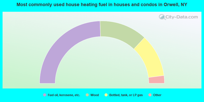
- 49.0%Fuel oil, kerosene, etc.
- 24.8%Wood
- 22.2%Bottled, tank, or LP gas
- 2.3%Electricity
- 1.2%Other fuel
- 0.6%Coal or coke
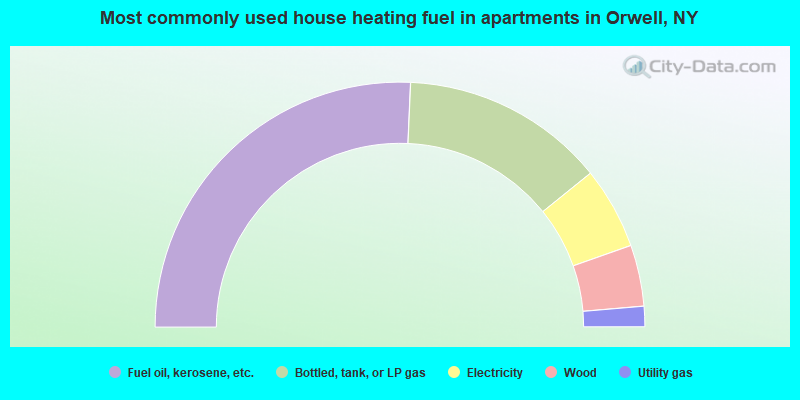
- 51.4%Fuel oil, kerosene, etc.
- 27.0%Bottled, tank, or LP gas
- 10.8%Electricity
- 8.1%Wood
- 2.7%Utility gas
Orwell compared to New York state average:
- Median house value significantly below state average.
- Black race population percentage significantly below state average.
- Hispanic race population percentage significantly below state average.
- Foreign-born population percentage significantly below state average.
- Renting percentage significantly below state average.
- Length of stay since moving in significantly above state average.
- Number of rooms per house significantly below state average.
- House age significantly below state average.
- Percentage of population with a bachelor's degree or higher significantly below state average.
Orwell on our top lists:
- #2 on the list of "Top 101 cities with the largest percentage of people in homes or halfway houses for drug/alcohol abuse (population 1,000+)"
- #40 on the list of "Top 101 counties with the lowest percentage of residents relocating from foreign countries between 2010 and 2011"
- #81 on the list of "Top 101 counties with the largest increase in the number of births per 1000 residents 2000-2006 to 2007-2013 (pop 50,000+)"
- #94 on the list of "Top 101 counties with the smallest number of people without health insurance coverage in 2000 (pop. 50,000+)"