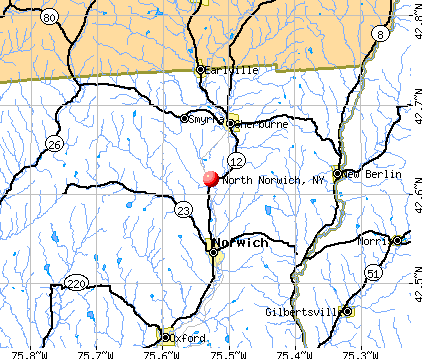
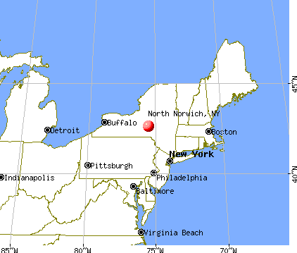
North Norwich, New York
Submit your own pictures of this town and show them to the world
- OSM Map
- General Map
- Google Map
- MSN Map
Population change since 2000: -9.3%
 |
| Males: 888 | |
| Females: 895 |
| Median resident age: | 42.9 years |
| New York median age: | 40.7 years |
Zip codes: 13815.
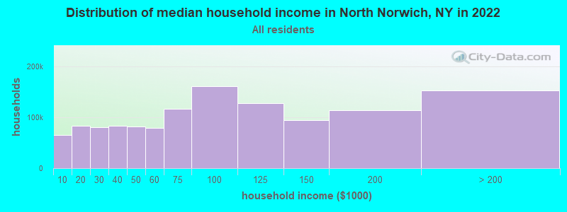
| North Norwich: | $67,111 |
| NY: | $79,557 |
Estimated per capita income in 2022: $34,071 (it was $17,022 in 2000)
North Norwich town income, earnings, and wages data
Estimated median house or condo value in 2022: $127,105 (it was $58,700 in 2000)
| North Norwich: | $127,105 |
| NY: | $400,400 |
Mean prices in 2022: all housing units: $153,408; detached houses: $176,469; townhouses or other attached units: $221,795; in 2-unit structures: $202,304; in 3-to-4-unit structures: $170,454; in 5-or-more-unit structures: $957,530; mobile homes: $68,668; occupied boats, rvs, vans, etc.: $114,445
Detailed information about poverty and poor residents in North Norwich, NY
Compare current foreclosures near North Norwich, NY:
| Photo | Address | Area | Beds / Baths | Price | Details |
|---|---|---|---|---|---|

|
#1
N Washington Ave
Oxford, NY 13830
|
2,234 sq. feet
|
2 baths 4 beds |
$121,500
|
show details |

|
#2
Old State Highway 23 # 23
South Plymouth, NY 13844
|
1,196 sq. feet
|
2 baths 3 beds |
$25,900
|
show details |

|
#3
County Road 10
Norwich, NY 13815
|
1,572 sq. feet
|
1 baths 5 beds |
$15,900
|
show details |

|
#4
Henry St
Norwich, NY 13815
|
2,560 sq. feet
|
1 baths 3 beds |
$17,900
|
show details |

|
#5
Morgan Acres Rd
Norwich, NY 13815
|
960 sq. feet
|
1 baths 2 beds |
show details | |

|
#6
Division St
Norwich, NY 13815
|
2,113 sq. feet
|
2 baths 3 beds |
show details | |

|
#7
Wickwire Rd
Hubbardsville, NY 13355
|
2,788 sq. feet
|
2 baths 5 beds |
show details | |

|
#8
Commercial St
Gilbertsville, NY 13776
|
5 sq. feet
|
2 baths 6 beds |
show details | |

|
#9
Alice St
Oxford, NY 13830
|
1,162 sq. feet
|
1 baths 3 beds |
show details | |

|
#10
State Highway 12
Norwich, NY 13815
|
1,769 sq. feet
|
2 baths 4 beds |
show details |
| Photo | Address | Area | Beds / Baths | Price | Details |
|---|---|---|---|---|---|

|
#11
N Main St
Earlville, NY 13332
|
1,740 sq. feet
|
2 baths 3 beds |
show details | |

|
#12
Scott St
Oxford, NY 13830
|
2,840 sq. feet
|
2 baths 4 beds |
show details | |

|
#13
State Highway 220
Oxford, NY 13830
|
1,937 sq. feet
|
1 baths 4 beds |
show details | |

|
#14
State Highway 220
Mc Donough, NY 13801
|
768 sq. feet
|
1 baths 2 beds |
show details | |

|
#15
County Road 3
Oxford, NY 13830
|
1,351 sq. feet
|
1 baths 4 beds |
show details | |

|
#16
Moss St
New Berlin, NY 13411
|
808 sq. feet
|
1 baths 3 beds |
show details | |

|
#17
Division St
Norwich, NY 13815
|
1,947 sq. feet
|
2 baths 4 beds |
show details | |

|
#18
School St
Sherburne, NY 13460
|
868 sq. feet
|
1 baths 3 beds |
show details | |

|
#19
Fair St
Norwich, NY 13815
|
2,234 sq. feet
|
2 baths 3 beds |
show details | |

|
#20
Canasawacta St
Norwich, NY 13815
|
2,410 sq. feet
|
4 baths 4 beds |
show details |
| Photo | Address | Area | Beds / Baths | Price | Details |
|---|---|---|---|---|---|

|
#21
County Road 31
Norwich, NY 13815
|
1,040 sq. feet
|
1 baths 3 beds |
show details | |

|
#22
Eric St
Norwich, NY 13815
|
864 sq. feet
|
1 baths 3 beds |
show details | |

|
#23
Collins Rd
Earlville, NY 13332
|
1,248 sq. feet
|
2 baths 3 beds |
show details | |

|
#24
Beaver Creek Rd
Brookfield, NY 13314
|
2,166 sq. feet
|
2 baths 4 beds |
show details | |

|
#25
Broad St
Morris, NY 13808
|
4,112 sq. feet
|
3 baths 6 beds |
show details | |

|
#26
Rexford St
Norwich, NY 13815
|
1,608 sq. feet
|
2 baths 3 beds |
show details | |

|
#27
Willey Rd
Earlville, NY 13332
|
1,900 sq. feet
|
2 baths 3 beds |
show details | |

|
#28
Diamond St
Norwich, NY 13815
|
1,436 sq. feet
|
2 baths 3 beds |
show details | |

|
#29
County Road 35
Guilford, NY 13780
|
1,800 sq. feet
|
1 baths 3 beds |
show details | |

|
#30
Sheldon St
Norwich, NY 13815
|
1,844 sq. feet
|
1 baths 3 beds |
show details |
| Photo | Address | Area | Beds / Baths | Price | Details |
|---|---|---|---|---|---|

|
#31
Canasawacta St
Norwich, NY 13815
|
1,386 sq. feet
|
1 baths 3 beds |
show details | |

|
#32
State Highway 23
Morris, NY 13808
|
1,512 sq. feet
|
2 baths 3 beds |
show details | |

|
#33
Walnut St
Norwich, NY 13815
|
1,869 sq. feet
|
2 baths 2 beds |
show details | |

|
#34
County Road 36
Guilford, NY 13780
|
988 sq. feet
|
2 baths 4 beds |
show details | |

|
#35
Vosburg Rd
Earlville, NY 13332
|
1,044 sq. feet
|
1 baths 1 beds |
show details | |

|
#36
State Highway 8
South New Berlin, NY 13843
|
2,424 sq. feet
|
1 baths 3 beds |
show details | |

|
#37
Wahlberg Rd
Norwich, NY 13815
|
2,062 sq. feet
|
1 baths 2 beds |
show details | |

|
#38
Lyon Brook Rd
Norwich, NY 13815
|
1,232 sq. feet
|
1 baths 3 beds |
show details | |

|
#39
Quaker Hill Rd
West Edmeston, NY 13485
|
1,944 sq. feet
|
1 baths 2 beds |
show details | |

|
#40
Creek Rd
Mc Donough, NY 13801
|
1,217 sq. feet
|
1 baths 3 beds |
show details |
| Photo | Address | Area | Beds / Baths | Price | Details |
|---|---|---|---|---|---|

|
#41
County Road 10a
Norwich, NY 13815
|
1,632 sq. feet
|
1 baths 4 beds |
show details | |

|
#42
County Road 16
Plymouth, NY 13832
|
1,600 sq. feet
|
1 baths 3 beds |
show details | |

|
#43
Birdsall St
Norwich, NY 13815
|
1,407 sq. feet
|
2 baths 3 beds |
show details | |

|
#44
Francis Ave
Norwich, NY 13815
|
1,506 sq. feet
|
1 baths 3 beds |
show details | |

|
#45
Sheldon St
Norwich, NY 13815
|
1,971 sq. feet
|
2 baths 5 beds |
show details | |

|
#46
Miller St
Norwich, NY 13815
|
1,425 sq. feet
|
1 baths 3 beds |
show details | |

|
#47
Plymouth St
Norwich, NY 13815
|
764 sq. feet
|
1 baths 3 beds |
show details | |

|
#48
Rexford Falls Rd
Sherburne, NY 13460
|
3,124 sq. feet
|
2 baths 4 beds |
show details | |

|
#49
Poolville Rd
Hubbardsville, NY 13355
|
1,748 sq. feet
|
1 baths 5 beds |
show details | |

|
Check over 1 million property listings on Foreclosure.com!
|
browse all offers | |||

- 1,71696.2%White alone
- 211.2%Hispanic
- 181.0%Two or more races
- 120.7%Asian alone
- 90.5%Black alone
- 70.4%American Indian alone
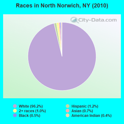
Races in North Norwich detailed stats: ancestries, foreign born residents, place of birth
According to our research of New York and other state lists, there was 1 registered sex offender living in North Norwich, New York as of July 03, 2024.
The ratio of all residents to sex offenders in North Norwich is 1,783 to 1.
The ratio of registered sex offenders to all residents in this city is lower than the state average.
 Recent articles from our blog. Our writers, many of them Ph.D. graduates or candidates, create easy-to-read articles on a wide variety of topics.

 | Pa or NYS? (25 replies) |
Latest news from North Norwich, NY collected exclusively by city-data.com from local newspapers, TV, and radio stations
Ancestries: English (20.5%), German (19.9%), Irish (16.2%), Italian (9.2%), United States (8.3%), Dutch (6.3%).
Current Local Time: EST time zone
Land area: 28.2 square miles.
Population density: 63 people per square mile (very low).
49 residents are foreign born (1.2% Europe, 0.9% North America, 0.5% Asia).
| This town: | 2.5% |
| New York: | 20.4% |
| North Norwich town: | 3.0% ($1,781) |
| New York: | 1.9% ($2,847) |
Nearest city with pop. 50,000+: Utica, NY  (36.5 miles , pop. 60,651).
Nearest city with pop. 200,000+: Rochester, NY (113.3 miles , pop. 219,773).
Nearest city with pop. 1,000,000+: Bronx, NY (148.3 miles , pop. 1,332,650).
Nearest cities:
), ), Latitude: 42.61 N, Longitude: 75.51 W
Area code commonly used in this area: 607

| Here: | 4.2% |
| New York: | 4.4% |
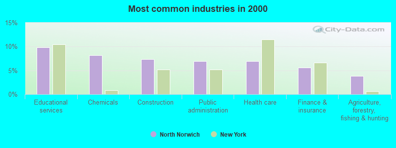
- Educational services (9.9%)
- Chemicals (8.2%)
- Construction (7.3%)
- Public administration (6.9%)
- Health care (6.9%)
- Finance & insurance (5.6%)
- Agriculture, forestry, fishing & hunting (3.8%)
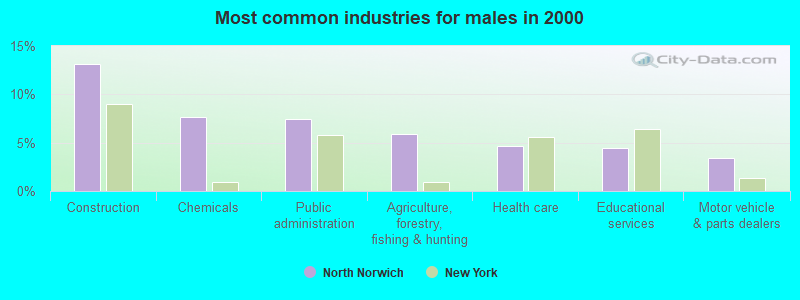
- Construction (13.2%)
- Chemicals (7.7%)
- Public administration (7.5%)
- Agriculture, forestry, fishing & hunting (5.9%)
- Health care (4.7%)
- Educational services (4.5%)
- Motor vehicle & parts dealers (3.4%)
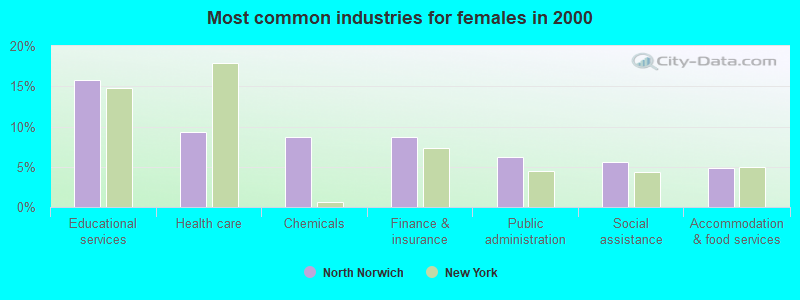
- Educational services (15.8%)
- Health care (9.4%)
- Chemicals (8.7%)
- Finance & insurance (8.7%)
- Public administration (6.2%)
- Social assistance (5.6%)
- Accommodation & food services (4.9%)
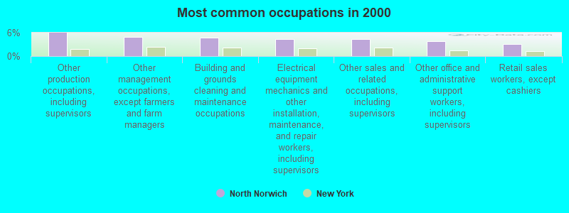
- Other production occupations, including supervisors (5.9%)
- Other management occupations, except farmers and farm managers (4.9%)
- Building and grounds cleaning and maintenance occupations (4.8%)
- Electrical equipment mechanics and other installation, maintenance, and repair workers, including supervisors (4.5%)
- Other sales and related occupations, including supervisors (4.3%)
- Other office and administrative support workers, including supervisors (3.8%)
- Retail sales workers, except cashiers (3.1%)
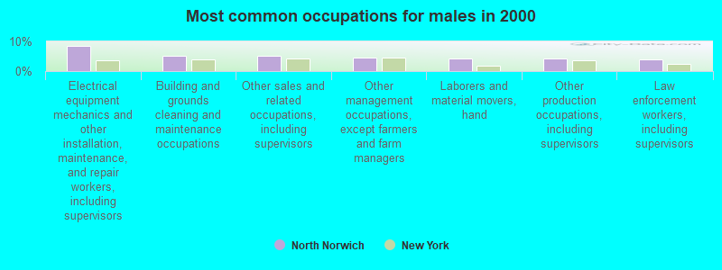
- Electrical equipment mechanics and other installation, maintenance, and repair workers, including supervisors (8.5%)
- Building and grounds cleaning and maintenance occupations (5.1%)
- Other sales and related occupations, including supervisors (5.1%)
- Other management occupations, except farmers and farm managers (4.5%)
- Laborers and material movers, hand (4.3%)
- Other production occupations, including supervisors (4.3%)
- Law enforcement workers, including supervisors (4.0%)
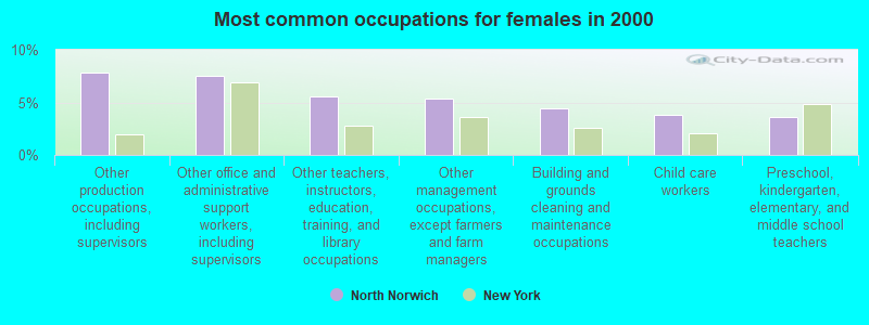
- Other production occupations, including supervisors (7.8%)
- Other office and administrative support workers, including supervisors (7.6%)
- Other teachers, instructors, education, training, and library occupations (5.6%)
- Other management occupations, except farmers and farm managers (5.3%)
- Building and grounds cleaning and maintenance occupations (4.5%)
- Child care workers (3.8%)
- Preschool, kindergarten, elementary, and middle school teachers (3.6%)
Average climate in North Norwich, New York
Based on data reported by over 4,000 weather stations


(lower is better)
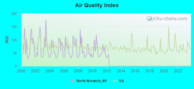
Air Quality Index (AQI) level in 2011 was 52.6. This is better than average.
| City: | 52.6 |
| U.S.: | 72.6 |
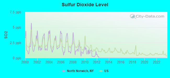
Sulfur Dioxide (SO2) [ppb] level in 2011 was 0.547. This is significantly better than average. Closest monitor was 16.4 miles away from the city center.
| City: | 0.547 |
| U.S.: | 1.515 |
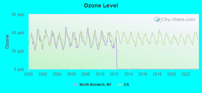
Ozone [ppb] level in 2011 was 30.6. This is about average. Closest monitor was 16.4 miles away from the city center.
| City: | 30.6 |
| U.S.: | 33.3 |
Tornado activity:
North Norwich-area historical tornado activity is slightly below New York state average. It is 68% smaller than the overall U.S. average.
On 5/31/1998, a category F3 (max. wind speeds 158-206 mph) tornado 21.5 miles away from the North Norwich town center injured 3 people and caused $800,000 in damages.
On 5/31/1998, a category F2 (max. wind speeds 113-157 mph) tornado 4.7 miles away from the town center caused $500,000 in damages.
Earthquake activity:
North Norwich-area historical earthquake activity is significantly above New York state average. It is 67% smaller than the overall U.S. average.On 10/7/1983 at 10:18:46, a magnitude 5.3 (5.1 MB, 5.3 LG, 5.1 ML, Class: Moderate, Intensity: VI - VII) earthquake occurred 109.9 miles away from North Norwich center
On 4/20/2002 at 10:50:47, a magnitude 5.3 (5.3 ML, Depth: 3.0 mi) earthquake occurred 159.9 miles away from the city center
On 4/20/2002 at 10:50:47, a magnitude 5.2 (5.2 MB, 4.2 MS, 5.2 MW, 5.0 MW) earthquake occurred 157.9 miles away from North Norwich center
On 8/23/2011 at 17:51:04, a magnitude 5.8 (5.8 MW, Depth: 3.7 mi) earthquake occurred 349.4 miles away from North Norwich center
On 6/17/1991 at 08:53:16, a magnitude 4.1 (4.0 MB, 4.0 LG, Depth: 3.1 mi, Class: Light, Intensity: IV - V) earthquake occurred 42.3 miles away from the city center
On 9/25/1998 at 19:52:52, a magnitude 5.2 (4.8 MB, 4.3 MS, 5.2 LG, 4.5 MW, Depth: 3.1 mi) earthquake occurred 262.6 miles away from North Norwich center
Magnitude types: regional Lg-wave magnitude (LG), body-wave magnitude (MB), local magnitude (ML), surface-wave magnitude (MS), moment magnitude (MW)
Natural disasters:
The number of natural disasters in Chenango County (25) is a lot greater than the US average (15).Major Disasters (Presidential) Declared: 14
Emergencies Declared: 8
Causes of natural disasters: Storms: 11, Floods: 9, Snowstorms: 3, Tropical Storms: 3, Hurricanes: 2, Tornadoes: 2, Winds: 2, Blizzard: 1, Ice Storm: 1, Power Outage: 1, Tropical Depression: 1, Winter Storm: 1, Other: 2 (Note: some incidents may be assigned to more than one category).
Hospitals and medical centers near North Norwich:
- NORWICH REHABILITATION AND NURSING CENTER (Nursing Home, about 5 miles away; NORWICH, NY)
- CHENANGO MEMORIAL HOSPITAL, INC Acute Care Hospitals (about 5 miles away; NORWICH, NY)
- VALLEY VIEW MANOR NURSING HOME (Nursing Home, about 6 miles away; NORWICH, NY)
- HOSPICE OF CHENANGO COUNTY (Hospital, about 6 miles away; NORWICH, NY)
- N Y S VETS HOME AT OXFORD (Nursing Home, about 12 miles away; OXFORD, NY)
- COMMUNITY MEMORIAL HOSPITAL, INC Acute Care Hospitals (about 15 miles away; HAMILTON, NY)
- FAXTON ST LUKE'S HEALTHCARE - HAMILTON (Dialysis Facility, about 16 miles away; HAMILTON, NY)
Colleges/universities with over 2000 students nearest to North Norwich:
- Colgate University (about 15 miles; Hamilton, NY; Full-time enrollment: 3,094)
- Morrisville State College (about 21 miles; Morrisville, NY; FT enrollment: 2,823)
- SUNY Oneonta (about 25 miles; Oneonta, NY; FT enrollment: 6,081)
- SUNY College at Cortland (about 36 miles; Cortland, NY; FT enrollment: 6,838)
- Mohawk Valley Community College (about 36 miles; Utica, NY; FT enrollment: 5,693)
- Utica College (about 36 miles; Utica, NY; FT enrollment: 2,952)
- SUNY College of Technology at Delhi (about 38 miles; Delhi, NY; FT enrollment: 2,911)
Points of interest:
Notable locations in North Norwich: Kings Settlement (A), Alishauskas Dairy (B), North Norwich Fire Department (C). Display/hide their locations on the map
Cemeteries: Bloom Cemetery (1), North Norwich Cemetery (2), Plasterville Cemetery (3), Kings Settlement Cemetery (4). Display/hide their locations on the map
Lake: Mead Pond (A). Display/hide its location on the map
Streams, rivers, and creeks: Fly Creek (A), Whapanaka Brook (B), West Brook (C), Cold Brook (D). Display/hide their locations on the map
| This town: | 2.5 people |
| New York: | 2.6 people |
| This town: | 71.2% |
| Whole state: | 63.5% |
| This town: | 11.2% |
| Whole state: | 6.8% |
Likely homosexual households (counted as self-reported same-sex unmarried-partner households)
- Lesbian couples: 0.4% of all households
- Gay men: 0.3% of all households
| This town: | 16.1% |
| Whole state: | 14.6% |
| This town: | 6.3% |
| Whole state: | 7.4% |
For population 15 years and over in North Norwich:
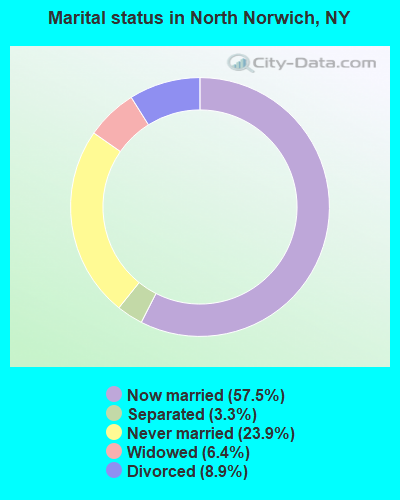
- Never married: 23.9%
- Now married: 57.5%
- Separated: 3.3%
- Widowed: 6.4%
- Divorced: 8.9%
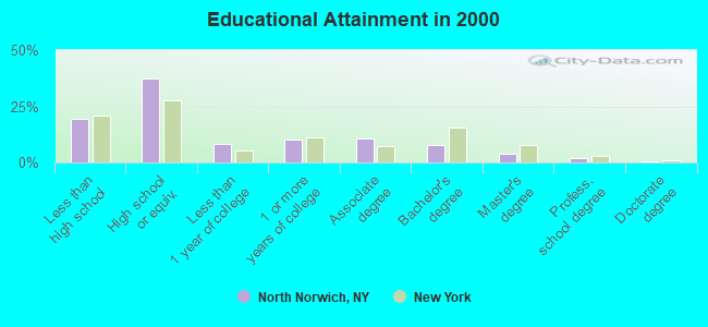
For population 25 years and over in North Norwich:
- High school or higher: 80.5%
- Bachelor's degree or higher: 14.1%
- Graduate or professional degree: 6.3%
- Unemployed: 3.6%
- Mean travel time to work (commute): 24.0 minutes
| Here: | 11.2 |
| New York average: | 14.2 |
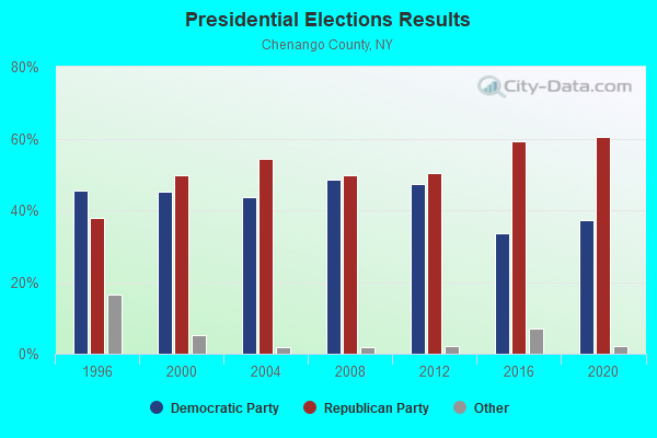
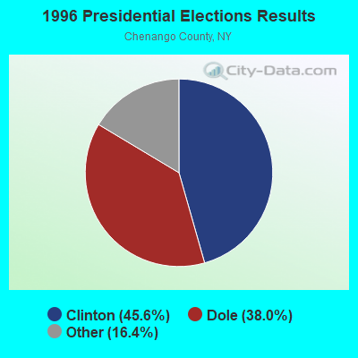
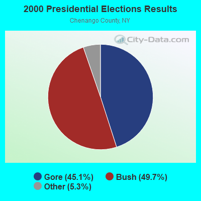
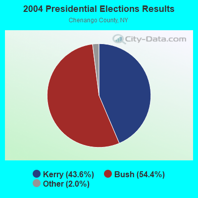
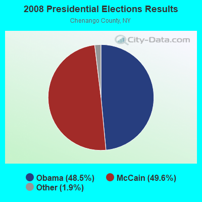
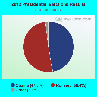
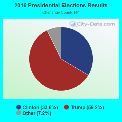
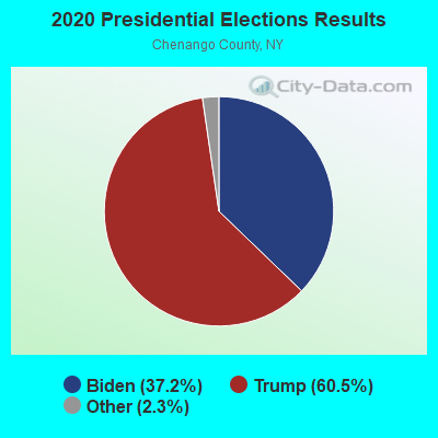
Graphs represent county-level data. Detailed 2008 Election Results
Religion statistics for North Norwich, NY (based on Chenango County data)
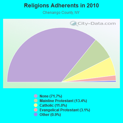
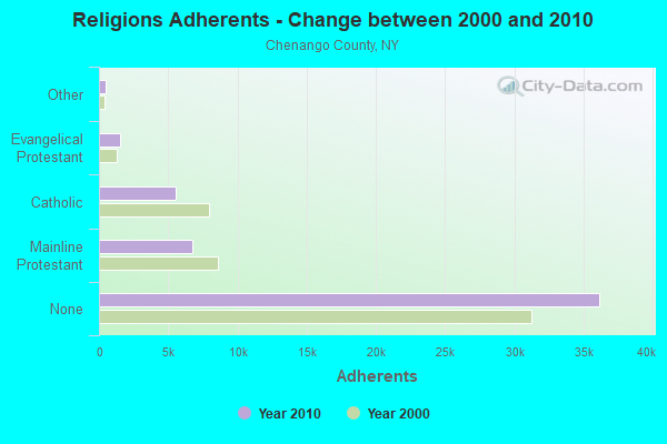
| Religion | Adherents | Congregations |
|---|---|---|
| Mainline Protestant | 6,744 | 39 |
| Catholic | 5,528 | 8 |
| Evangelical Protestant | 1,563 | 25 |
| Other | 471 | 5 |
| None | 36,171 | - |
Food Environment Statistics:
| This county: | 2.54 / 10,000 pop. |
| State: | 4.13 / 10,000 pop. |
| This county: | 0.39 / 10,000 pop. |
| State: | 0.92 / 10,000 pop. |
| Chenango County: | 5.87 / 10,000 pop. |
| New York: | 1.68 / 10,000 pop. |
| Chenango County: | 7.24 / 10,000 pop. |
| New York: | 8.82 / 10,000 pop. |
| This county: | 8.8% |
| New York: | 8.2% |
| Here: | 27.4% |
| New York: | 23.8% |
| This county: | 13.6% |
| New York: | 15.6% |
Strongest AM radio stations in North Norwich:
- WCHN (970 AM; 1 kW; NORWICH, NY; Owner: BANJO COMMUNICATIONS GROUP, INC)
- WGY (810 AM; 50 kW; SCHENECTADY, NY; Owner: CLEAR CHANNEL BROADCASTING LICENSES, INC.)
- WINR (680 AM; 5 kW; BINGHAMTON, NY; Owner: CLEVELAND RADIO LICENSES, LLC)
- WPTR (1540 AM; 50 kW; ALBANY, NY; Owner: KIMTRON, INC.)
- WSYR (570 AM; 5 kW; SYRACUSE, NY; Owner: CLEAR CHANNEL BROADCASTING LICENSES, INC.)
- WIBX (950 AM; 5 kW; UTICA, NY; Owner: REGENT LICENSEE OF UTICA/ROME, INC.)
- WMCA (570 AM; 50 kW; NEW YORK, NY; Owner: SALEM MEDIA OF NEW YORK, LLC)
- WNBF (1290 AM; 9 kW; BINGHAMTON, NY; Owner: CITADEL BROADCASTING COMPANY)
- WNNZ (640 AM; 50 kW; WESTFIELD, MA; Owner: CLEAR CHANNEL BROADCASTING LICENSES, INC.)
- WTLB (1310 AM; 5 kW; UTICA, NY; Owner: GALAXY COMMUNICATIONS, L.P.)
- WHEN (620 AM; 5 kW; SYRACUSE, NY; Owner: CLEAR CHANNEL BROADCASTING LICENSES, INC.)
- WOR (710 AM; 50 kW; NEW YORK, NY; Owner: BUCKLEY BROADCASTING CORPORATION)
- WFAN (660 AM; 50 kW; NEW YORK, NY; Owner: INFINITY BROADCASTING OPERATIONS, INC.)
Strongest FM radio stations in North Norwich:
- WKXZ (93.9 FM; NORWICH, NY; Owner: BANJO COMMUNICATIONS GROUP, INC)
- WBKT (95.3 FM; NORWICH, NY; Owner: BANJO COMMUNICATIONS GROUP, INC)
- WWDG (105.1 FM; DERUYTER, NY; Owner: CLEAR CHANNEL BROADCASTING LICENSES, INC.)
- WCDO-FM (100.9 FM; SIDNEY, NY; Owner: CDO BROADCASTING, INC.)
- WHWK (98.1 FM; BINGHAMTON, NY; Owner: CITADEL BROADCASTING COMPANY)
- WGKR (105.3 FM; GRAND GORGE, NY; Owner: SOUND OF LIFE, INC.)
- WMCR-FM (106.3 FM; ONEIDA, NY; Owner: WARREN BROADCASTING CO. INC.)
- WSKS (97.9 FM; WHITESBORO, NY; Owner: CLEAR CHANNEL BROADCASTING LICENSES, INC.)
- WRBY (102.5 FM; ROME, NY; Owner: CLEAR CHANNEL BROADCASTING LICENSES, INC.)
- WAAL (99.1 FM; BINGHAMTON, NY; Owner: CITADEL BROADCASTING COMPANY)
- WIII (99.9 FM; CORTLAND, NY; Owner: CITADEL BROADCASTING COMPANY)
- WJIV (101.9 FM; CHERRY VALLEY, NY; Owner: CHRISTIAN BROADCASTING SYSTEM, LTD.)
- WSKG-FM (89.3 FM; BINGHAMTON, NY; Owner: WSKG PUB.TELECOMMUNICATIONS COUNCIL)
- WSQC-FM (91.7 FM; ONEONTA, NY; Owner: WSKG PUBLIC TELECOMM. COUNCIL)
- WSRK (103.9 FM; ONEONTA, NY; Owner: ULTIMATE B/CASTING NETWORK, INC.)
- WMXW (103.3 FM; VESTAL, NY; Owner: CLEAR CHANNEL BROADCASTING LICENSES, INC.)
- WCNY-FM (91.3 FM; SYRACUSE, NY; Owner: THE PUB. B/C COUNC. OF CEN. NY, INC.)
- WSQX-FM (91.5 FM; BINGHAMTON, NY; Owner: WSKG PUBLIC TELECOMMUNICATIONS CNCL.)
- WNTQ (93.1 FM; SYRACUSE, NY; Owner: CITADEL BROADCASTING COMPANY)
- W257BE (99.3 FM; HAMILTON, NY; Owner: BANJO COMMUNICATIONS GROUP, INC)
TV broadcast stations around North Norwich:
- WFXV (Channel 33; UTICA, NY; Owner: QUORUM OF UTICA LICENSE, LLC)
- WIXT-TV (Channel 9; SYRACUSE, NY; Owner: CENTRAL NY NEWS, INC.)
- WCNY-TV (Channel 24; SYRACUSE, NY; Owner: PUBLIC BROADCASTING COUNCIL OF CENTRAL NEW YORK)
- WSTM-TV (Channel 3; SYRACUSE, NY; Owner: WSTM LICENSE SUBSIDIARY, INC.)
- WSYT (Channel 68; SYRACUSE, NY; Owner: WSYT LICENSEE L.P.)
- WNYS-TV (Channel 43; SYRACUSE, NY; Owner: RKM MEDIA, INC.)
- North Norwich, New York
- Fatal accident count8
- Vehicles involved in fatal accidents11
- Fatal accidents involving drunk persons:1
- Fatalities8
- Persons involved in fatal accidents16
- Pedestrians involved in fatal accidents1
- New York average
- Fatal accident count10742
- Vehicles involved in fatal accidents15832
- Fatal accidents involving drunk persons2393
- Fatalities11657
- Persons involved in fatal accidents26609
- Pedestrians involved in fatal accidents2756
- National Bridge Inventory (NBI) Statistics
- 8Number of bridges
- 56ft / 16.9mTotal length
- $10,368,000Total costs
- 33,353Total average daily traffic
- 4,039Total average daily truck traffic
- 33,879Total future (year 2037) average daily traffic
FCC Registered Antenna Towers:
3- Anthony Handley, German Hollow Road (Lat: 42.613722 Lon: -75.534972), Type: 60.7, Structure height: 36017 m, Overall height: 60.7 m, Registrant: Blue Sky Towers Iii, LLC, Chuck.Laurette@blueskytower.Com, Suite 106, North- Reading, Phone: (888) 960-7958
- Anthony Handley, German Hollow Road (Lat: 42.613722 Lon: -75.534972), Type: 60.7, Structure height: 36017 m, Overall height: 60.7 m, Registrant: Blue Sky Towers Iii, LLC, Chuck.Laurette@blueskytower.Com, Suite 106, North- Reading, Phone: (888) 960-7958
- Anthony Handley, German Hollow Road (Lat: 42.613722 Lon: -75.534972), Type: 60.7, Structure height: 36017 m, Overall height: 60.7 m, Registrant: Blue Sky Towers Iii, LLC, Chuck.Laurette@blueskytower.Com, Suite 106, North- Reading, Phone: (888) 960-7958
FCC Registered Broadcast Land Mobile Towers:
2- N Norwich Fire Dept N Main St (Lat: 42.617028 Lon: -75.528250), Call Sign: WNWH882,
Assigned Frequencies: 46.3800 MHz, Grant Date: 08/08/2001, Expiration Date: 05/23/2011, Cancellation Date: 07/23/2011, Registrant: County Of Chenango, 279 County Road 46, Norwich, NY 13815, Phone: (607) 337-1862, Fax: (607) 337-1865, Email:
- Lat: 42.608611 Lon: -75.529167, Call Sign: WPSJ446,
Assigned Frequencies: 452.400 MHz, 452.425 MHz, 457.400 MHz, Grant Date: 05/21/2001, Expiration Date: 05/21/2011, Cancellation Date: 07/23/2011, Certifier: Sheldon Goldstein, Registrant: Tri County Communications Inc, Oneonta, NY 13820, Phone: (607) 722-1493, Fax: (607) 722-3367
FCC Registered Amateur Radio Licenses:
1- Call Sign: KB2WTF, Licensee ID: L01075140, Grant Date: 02/16/2016, Expiration Date: 01/12/2026, Certifier: June M Tuttle, Registrant: June M Tuttle, North Norwich, NY 13814
2002 - 2018 National Fire Incident Reporting System (NFIRS) incidents
- Fire incident types reported to NFIRS in North Norwich, NY
- 6156.5%Structure Fires
- 1816.7%Outside Fires
- 1715.7%Mobile Property/Vehicle Fires
- 1211.1%Other
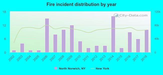 Based on the data from the years 2002 - 2018 the average number of fires per year is 6. The highest number of reported fire incidents - 16 took place in 2014, and the least - 1 in 2002. The data has a rising trend.
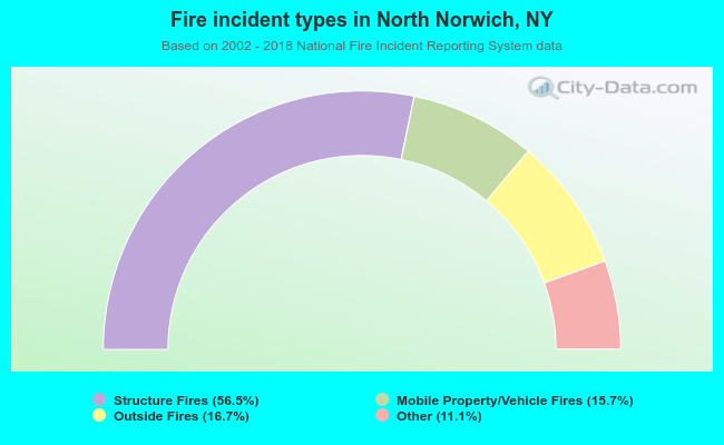 When looking into fire subcategories, the most reports belonged to: Structure Fires (56.5%), and Outside Fires (16.7%).
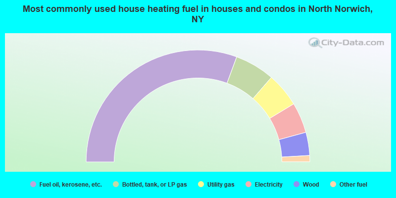
- 61.2%Fuel oil, kerosene, etc.
- 11.5%Bottled, tank, or LP gas
- 9.9%Utility gas
- 8.8%Electricity
- 6.7%Wood
- 1.8%Other fuel
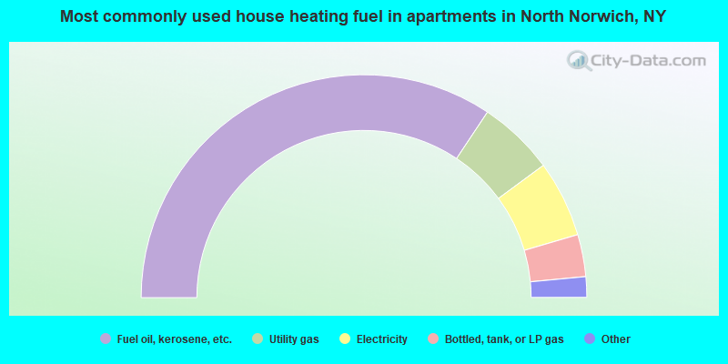
- 68.7%Fuel oil, kerosene, etc.
- 11.1%Utility gas
- 11.1%Electricity
- 6.1%Bottled, tank, or LP gas
- 2.0%Solar energy
- 1.0%Wood
North Norwich compared to New York state average:
- Median house value significantly below state average.
- Unemployed percentage significantly below state average.
- Black race population percentage significantly below state average.
- Hispanic race population percentage significantly below state average.
- Foreign-born population percentage significantly below state average.
- Renting percentage significantly below state average.
- Length of stay since moving in significantly above state average.
- Number of rooms per house significantly below state average.
- House age significantly below state average.
- Number of college students below state average.
- Percentage of population with a bachelor's degree or higher below state average.