Needmore, Alabama
Submit your own pictures of this place and show them to the world
- OSM Map
- General Map
- Google Map
- MSN Map

| Males: 902 | |
| Females: 895 |
| Median resident age: | 33.7 years |
| Alabama median age: | 35.8 years |
Zip code: 36081
| Needmore: | $43,245 |
| AL: | $59,674 |
Estimated per capita income in 2022: $23,874 (it was $13,163 in 2000)
Needmore CCD income, earnings, and wages data
Estimated median house or condo value in 2022: $94,811 (it was $34,100 in 2000)
| Needmore: | $94,811 |
| AL: | $200,900 |
Detailed information about poverty and poor residents in Needmore, AL


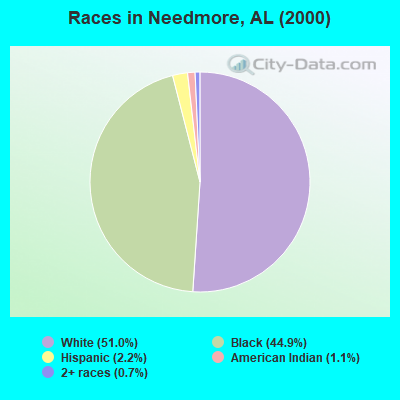
- 90451.0%White alone
- 79544.9%Black alone
- 392.2%Hispanic
- 201.1%American Indian alone
- 130.7%Two or more races
 Recent articles from our blog. Our writers, many of them Ph.D. graduates or candidates, create easy-to-read articles on a wide variety of topics.

Current Local Time: CST time zone
Land area: 101.5 square miles.
Population density: 18 people per square mile (very low).

| Needmore CCD: | 0.6% ($199) |
| Alabama: | 0.4% ($289) |
Nearest city with pop. 50,000+: Montgomery, AL  (35.4 miles , pop. 201,568).
Nearest city with pop. 1,000,000+: Houston, TX (579.5 miles , pop. 1,953,631).
Nearest cities:
), ), ), ), ), )Latitude: 31.93 N, Longitude: 85.95 W
Area code commonly used in this area: 334

| Here: | 3.2% |
| Alabama: | 2.6% |
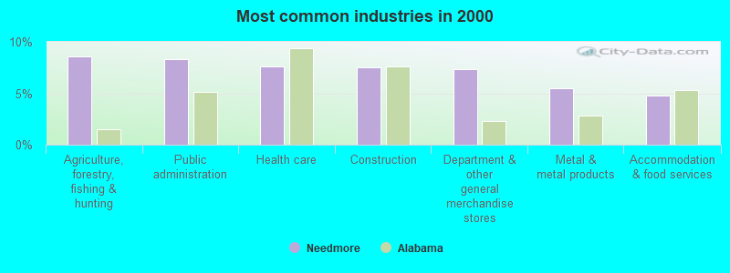
- Agriculture, forestry, fishing & hunting (8.6%)
- Public administration (8.3%)
- Health care (7.6%)
- Construction (7.5%)
- Department & other general merchandise stores (7.4%)
- Metal & metal products (5.5%)
- Accommodation & food services (4.8%)
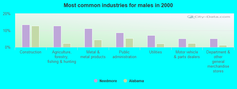
- Construction (13.5%)
- Agriculture, forestry, fishing & hunting (12.7%)
- Metal & metal products (11.1%)
- Public administration (8.6%)
- Utilities (7.0%)
- Motor vehicle & parts dealers (5.1%)
- Department & other general merchandise stores (5.1%)
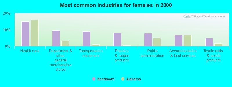
- Health care (15.1%)
- Department & other general merchandise stores (9.5%)
- Transportation equipment (9.0%)
- Plastics & rubber products (8.2%)
- Public administration (7.9%)
- Accommodation & food services (6.9%)
- Textile mills & textile products (5.0%)
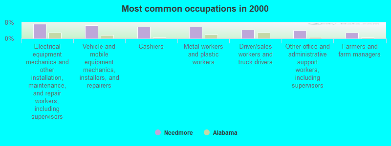
- Electrical equipment mechanics and other installation, maintenance, and repair workers, including supervisors (7.4%)
- Vehicle and mobile equipment mechanics, installers, and repairers (6.6%)
- Cashiers (5.9%)
- Metal workers and plastic workers (5.9%)
- Driver/sales workers and truck drivers (4.3%)
- Other office and administrative support workers, including supervisors (4.0%)
- Farmers and farm managers (2.9%)
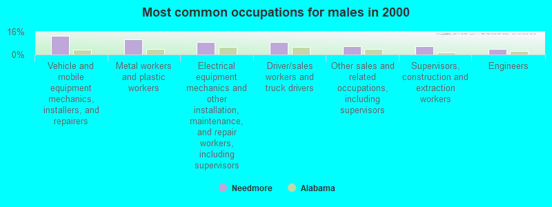
- Vehicle and mobile equipment mechanics, installers, and repairers (13.2%)
- Metal workers and plastic workers (10.8%)
- Electrical equipment mechanics and other installation, maintenance, and repair workers, including supervisors (8.6%)
- Driver/sales workers and truck drivers (8.6%)
- Other sales and related occupations, including supervisors (5.9%)
- Supervisors, construction and extraction workers (5.9%)
- Engineers (4.1%)
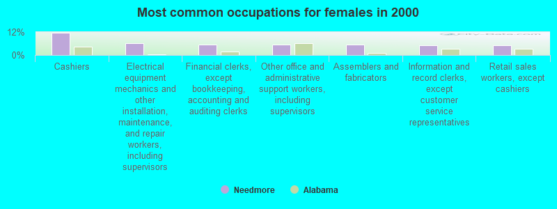
- Cashiers (11.6%)
- Electrical equipment mechanics and other installation, maintenance, and repair workers, including supervisors (6.1%)
- Financial clerks, except bookkeeping, accounting and auditing clerks (5.3%)
- Other office and administrative support workers, including supervisors (5.3%)
- Assemblers and fabricators (5.3%)
- Information and record clerks, except customer service representatives (5.0%)
- Retail sales workers, except cashiers (5.0%)
Average climate in Needmore, Alabama
Based on data reported by over 4,000 weather stations


(lower is better)
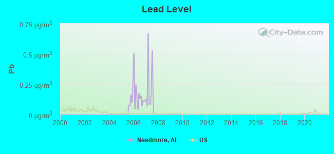
Lead (Pb) [µg/m3] level in 2007 was 0.230. This is significantly worse than average. Closest monitor was 9.6 miles away from the city center.
| City: | 0.230 |
| U.S.: | 0.009 |
Tornado activity:
Needmore-area historical tornado activity is slightly below Alabama state average. It is 42% greater than the overall U.S. average.
On 4/18/1969, a category F4 (max. wind speeds 207-260 mph) tornado 20.5 miles away from the Needmore place center killed 2 people and injured 14 people and caused between $50,000 and $500,000 in damages.
On 12/19/1974, a category F3 (max. wind speeds 158-206 mph) tornado 1.0 miles away from the place center injured one person and caused between $500 and $5000 in damages.
Earthquake activity:
Needmore-area historical earthquake activity is significantly above Alabama state average. It is 42% greater than the overall U.S. average.On 10/24/1997 at 08:35:17, a magnitude 4.9 (4.8 MB, 4.2 MS, 4.9 LG, Depth: 6.2 mi, Class: Light, Intensity: IV - V) earthquake occurred 95.7 miles away from Needmore center
On 1/18/1999 at 07:00:53, a magnitude 4.8 (4.8 MB, 4.0 LG, Depth: 0.6 mi) earthquake occurred 127.1 miles away from Needmore center
On 4/29/2003 at 08:59:39, a magnitude 4.9 (4.4 MB, 4.6 MW, 4.9 LG) earthquake occurred 178.3 miles away from the city center
On 4/29/2003 at 08:59:39, a magnitude 4.6 (4.6 MW, Depth: 12.3 mi) earthquake occurred 178.3 miles away from Needmore center
On 8/2/1974 at 08:52:09, a magnitude 4.9 (4.3 MB, 4.9 LG) earthquake occurred 241.9 miles away from Needmore center
On 6/24/1975 at 11:11:36, a magnitude 4.5 (4.5 MB) earthquake occurred 165.3 miles away from the city center
Magnitude types: regional Lg-wave magnitude (LG), body-wave magnitude (MB), surface-wave magnitude (MS), moment magnitude (MW)
Natural disasters:
The number of natural disasters in Pike County (16) is near the US average (15).Major Disasters (Presidential) Declared: 9
Emergencies Declared: 5
Causes of natural disasters: Storms: 7, Hurricanes: 6, Floods: 5, Tornadoes: 5, Winds: 3, Drought: 1, Snowfall: 1, Winter Storm: 1, Other: 1 (Note: some incidents may be assigned to more than one category).
Hospitals and medical centers near Needmore:
Colleges/universities with over 2000 students nearest to Needmore:
- Troy University (about 9 miles; Troy, AL; Full-time enrollment: 16,148)
- Auburn University at Montgomery (about 34 miles; Montgomery, AL; FT enrollment: 4,092)
- Faulkner University (about 35 miles; Montgomery, AL; FT enrollment: 2,887)
- Alabama State University (about 37 miles; Montgomery, AL; FT enrollment: 5,457)
- Tuskegee University (about 38 miles; Tuskegee, AL; FT enrollment: 2,810)
- Enterprise State Community College (about 45 miles; Enterprise, AL; FT enrollment: 2,101)
- George C Wallace State Community College-Dothan (about 52 miles; Dothan, AL; FT enrollment: 3,611)
Points of interest:
Notable locations in Needmore: Conecuh (A), Meeksville Volunteer Fire Department (B). Display/hide their locations on the map
Churches in Needmore include: Mount Olive Church (A), Mount Pleasant Church (B), New Mount Pleasant Missionary Baptist Church (C), Orion Church (D), Oak Grove United Methodist Church (E), Benevolent Grove Church (F), Concord Church (G), Full Gospel Church (H), Orion Church (I). Display/hide their locations on the map
Cemeteries: China Grove Cemetery (1), Dennis Cemetery (2), Kelley Cemetery (3), McNeil-Townsend Cemetery (4), Tick Hill Cemetery (5), Williams and Andrew Jackson Cemetery (6), Mount Gilead Cemetery (7). Display/hide their locations on the map
Reservoirs: Shirley Pond (A), Lake Haven (B), Costons Pond (C), Copelands Pond (D). Display/hide their locations on the map
Streams, rivers, and creeks: Ross Branch (A), Mannings Creek (B), Panther Creek (C), Nappy Head Branch (D), Moccasin Branch (E), Mill Creek (F), Jackson Creek (G), Hurricane Branch (H), Dicky Creek (I). Display/hide their locations on the map
| This place: | 2.4 people |
| Alabama: | 2.5 people |
| This place: | 64.0% |
| Whole state: | 67.8% |
| This place: | 7.5% |
| Whole state: | 4.7% |
Likely homosexual households (counted as self-reported same-sex unmarried-partner households)
- Lesbian couples: 0.1% of all households
- Gay men: 0.6% of all households
| This place: | 22.6% |
| Whole state: | 16.1% |
| This place: | 12.1% |
| Whole state: | 7.3% |
For population 15 years and over in Needmore:
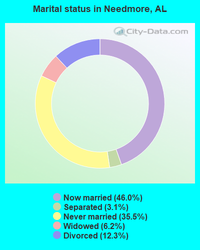
- Never married: 35.5%
- Now married: 46.0%
- Separated: 3.1%
- Widowed: 6.2%
- Divorced: 12.3%
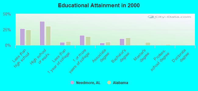
For population 25 years and over in Needmore:
- High school or higher: 73.5%
- Bachelor's degree or higher: 10.5%
- Graduate or professional degree: 0.0%
- Unemployed: 8.4%
- Mean travel time to work (commute): 29.1 minutes
| Here: | 11.1 |
| Alabama average: | 13.2 |
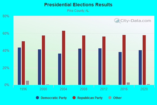
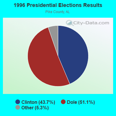
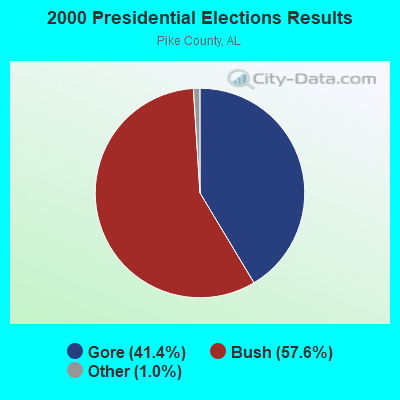

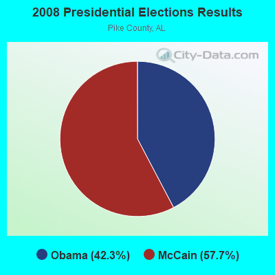
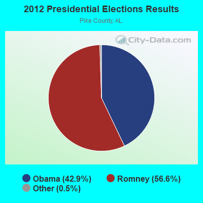
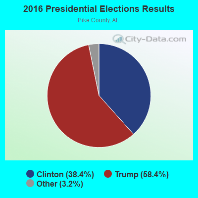
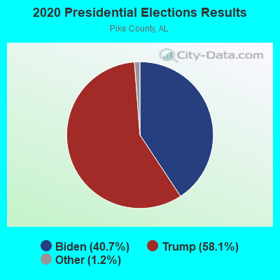
Graphs represent county-level data. Detailed 2008 Election Results
Religion statistics for Needmore, AL (based on Pike County data)
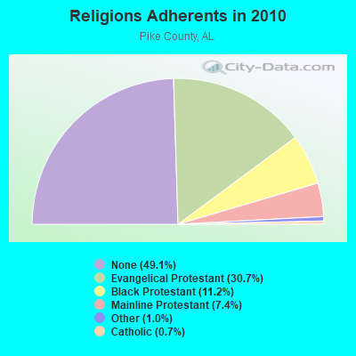
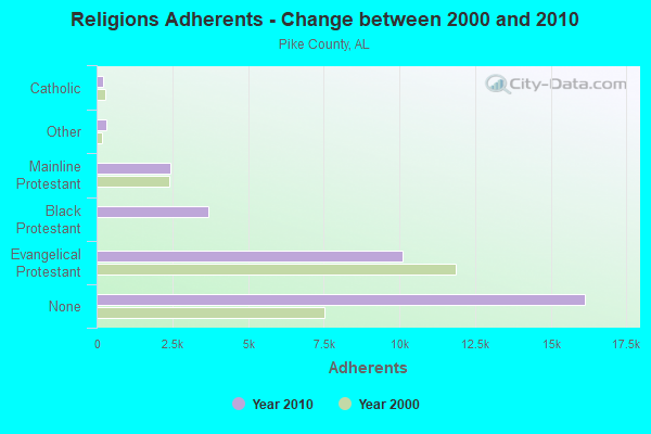
| Religion | Adherents | Congregations |
|---|---|---|
| Evangelical Protestant | 10,098 | 52 |
| Black Protestant | 3,675 | 19 |
| Mainline Protestant | 2,442 | 14 |
| Other | 325 | 3 |
| Catholic | 215 | 1 |
| None | 16,144 | - |
Food Environment Statistics:
| Pike County: | 2.65 / 10,000 pop. |
| Alabama: | 1.89 / 10,000 pop. |
| Here: | 0.33 / 10,000 pop. |
| Alabama: | 0.20 / 10,000 pop. |
| Here: | 0.66 / 10,000 pop. |
| Alabama: | 0.65 / 10,000 pop. |
| This county: | 5.30 / 10,000 pop. |
| Alabama: | 6.32 / 10,000 pop. |
| This county: | 5.63 / 10,000 pop. |
| State: | 5.75 / 10,000 pop. |
| Pike County: | 12.2% |
| Alabama: | 11.8% |
| Here: | 36.7% |
| Alabama: | 31.7% |
| Pike County: | 14.4% |
| Alabama: | 13.5% |
Strongest AM radio stations in Needmore:
- WTBF (970 AM; 5 kW; TROY, AL; Owner: TROY BROADCASTING CORP.)
- WMSP (740 AM; 10 kW; MONTGOMERY, AL; Owner: CUMULUS LICENSING CORP.)
- WQLS (1200 AM; 10 kW; OZARK, AL; Owner: STYLES BROADCASTING OF DOTHAN, INC.)
- WACV (1170 AM; 10 kW; MONTGOMERY, AL; Owner: MONTGOMERY BROADCAST PROPERTIES, LTD)
- WJOX (690 AM; 50 kW; BIRMINGHAM, AL; Owner: CITADEL BROADCASTING COMPANY)
- WDJC (850 AM; 50 kW; BIRMINGHAM, AL; Owner: KIMTRON, INC.)
- WLWI (1440 AM; 5 kW; MONTGOMERY, AL; Owner: CUMULUS LICENSING CORP.)
- WNSI (810 AM; 50 kW; JACKSONVILLE, AL; Owner: UNITED BROADCASTING NETWORK, INC.)
- WASG (550 AM; 25 kW; ATMORE, AL; Owner: 550 AM, INC)
- WGST (640 AM; 50 kW; ATLANTA, GA; Owner: CITICASTERS LICENSES, L.P.)
- WAPI (1070 AM; 50 kW; BIRMINGHAM, AL; Owner: CITADEL BROADCASTING COMPANY)
- WKNG (1060 AM; daytime; 50 kW; TALLAPOOSA, GA; Owner: WKNG, INC.)
- WMAC (940 AM; 50 kW; MACON, GA; Owner: CUMULUS LICENSING CORP.)
Strongest FM radio stations in Needmore:
- WQLD (104.3 FM; LUVERNE, AL; Owner: CAPSTAR TX LIMITED PARTNERSHIP)
- WZHT (105.7 FM; TROY, AL; Owner: CAPSTAR TX LIMITED PARTNERSHIP)
- WTSU (89.9 FM; MONTGOMERY-TROY, AL; Owner: TROY STATE UNIVERSITY)
- WAXU (91.1 FM; TROY, AL; Owner: AMERICAN FAMILY ASSOCIATION)
- WTBF-FM (94.7 FM; BRUNDIDGE, AL; Owner: TROY BROADCASTING CORPORATION)
- WLWI-FM (92.3 FM; MONTGOMERY, AL; Owner: CUMULUS LICENSING CORP.)
- WBAM-FM (98.9 FM; MONTGOMERY, AL; Owner: DEEP SOUTH BROADCASTING COMPANY)
- WHHY-FM (101.9 FM; MONTGOMERY, AL; Owner: CUMULUS LICENSING CORP.)
- WKMX (106.7 FM; ENTERPRISE, AL; Owner: WKMX, INC.)
- WMXS (103.3 FM; MONTGOMERY, AL; Owner: CUMULUS LICENSING CORP.)
- WAPR (88.3 FM; SELMA, AL; Owner: UA-ASU-TSU EDUCATIONAL RADIO CORP.)
- WMCZ (97.1 FM; MILLBROOK, AL; Owner: CAPSTAR TX LIMITED PARTNERSHIP)
- WQKS-FM (96.1 FM; MONTGOMERY, AL; Owner: MONTGOMERY BROADCAST PROPERTIES, LTD)
- WZTZ (101.1 FM; ELBA, AL; Owner: ELBA RADIO COMPANY)
- WAOQ (100.3 FM; BRANTLEY, AL; Owner: ALATRON CORPORATION, INC.)
TV broadcast stations around Needmore:
- WRJM-TV (Channel 67; TROY, AL; Owner: JOSIE PARK BROADCASTING, INC.)
- WSFA (Channel 12; MONTGOMERY, AL; Owner: LIBCO, INC.)
- WCOV-TV (Channel 20; MONTGOMERY, AL; Owner: WOODS COMMUNICATIONS CORPORATION)
- WNCF (Channel 32; MONTGOMERY, AL; Owner: CHANNEL 32 MONTGOMERY LLC)
- WDIQ (Channel 2; DOZIER, AL; Owner: ALABAMA EDUCATIONAL TELEVISION COMMISSION)
- WMCF-TV (Channel 45; MONTGOMERY, AL; Owner: TRINITY BROADCASTING NETWORK)
- WAKA (Channel 8; SELMA, AL; Owner: ALABAMA BROADCASTING PARTNERS)
- WGIQ (Channel 43; LOUISVILLE, AL; Owner: ALABAMA EDUCATIONAL TELEVISION COMMISSION)
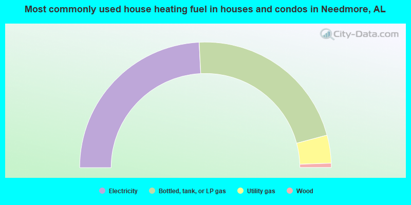
- 48.4%Electricity
- 43.3%Bottled, tank, or LP gas
- 7.2%Utility gas
- 1.1%Wood
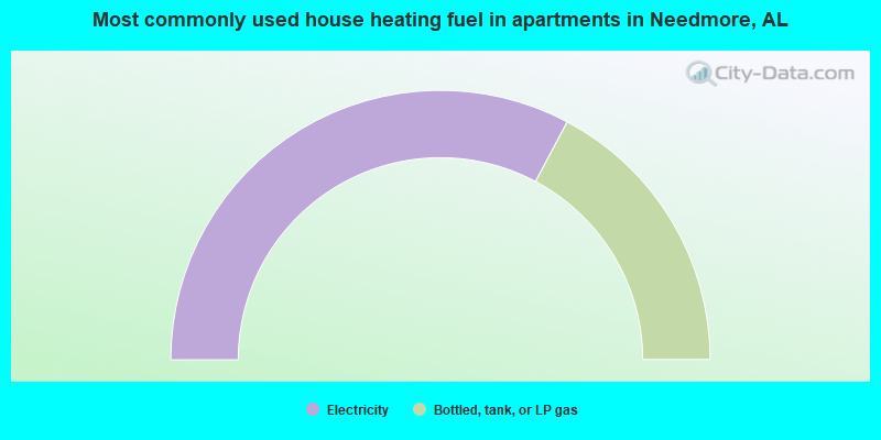
- 65.6%Electricity
- 34.4%Bottled, tank, or LP gas
Needmore compared to Alabama state average:
- Median house value below state average.
- Unemployed percentage below state average.
- Black race population percentage above state average.
- Hispanic race population percentage below state average.
- Median age significantly below state average.
- Foreign-born population percentage significantly below state average.
- Length of stay since moving in significantly above state average.
- Number of rooms per house significantly below state average.
- House age significantly below state average.
- Percentage of population with a bachelor's degree or higher below state average.