Mud Creek, Alabama
Submit your own pictures of this place and show them to the world
- OSM Map
- General Map
- Google Map
- MSN Map

| Males: 2,414 | |
| Females: 2,351 |
| Median resident age: | 38.3 years |
| Alabama median age: | 35.8 years |
Zip code: 35960
| Mud Creek: | $50,886 |
| AL: | $59,674 |
Estimated per capita income in 2022: $29,721 (it was $16,045 in 2000)
Mud Creek CCD income, earnings, and wages data
Estimated median house or condo value in 2022: $182,197 (it was $65,100 in 2000)
| Mud Creek: | $182,197 |
| AL: | $200,900 |
Detailed information about poverty and poor residents in Mud Creek, AL
Compare current foreclosures near Mud Creek, AL:
| Photo | Address | Area | Beds / Baths | Price | Details |
|---|---|---|---|---|---|

|
#1
Haslam St
Piedmont, AL 36272
|
1,408 sq. feet
|
2 baths 2 beds |
$170,000
|
show details |

|
#2
Al Hwy 9 S
Piedmont, AL 36272
|
3,200 sq. feet
|
- baths 4 beds |
$329,900
|
show details |

|
#3
Appleton St
Centre, AL 35960
|
2,075 sq. feet
|
2 baths 3 beds |
show details | |

|
#4
Piedmont Hwy
Centre, AL 35960
|
2,230 sq. feet
|
2 baths 3 beds |
show details | |

|
#5
Maple Dr
Cedartown, GA 30125
|
1,544 sq. feet
|
2 baths 3 beds |
show details | |

|
#6
Nathaniel Dr
Piedmont, AL 36272
|
2,304 sq. feet
|
2 baths 3 beds |
show details | |

|
#7
Michael Blvd
Cedartown, GA 30125
|
1,312 sq. feet
|
2 baths 3 beds |
show details | |

|
#8
Roberson Ct
Cedartown, GA 30125
|
1,368 sq. feet
|
2 baths 3 beds |
show details | |

|
#9
Hillside Dr
Cedartown, GA 30125
|
1,524 sq. feet
|
1 baths 3 beds |
show details | |

|
#10
John Redding Rd
Cedartown, GA 30125
|
1,872 sq. feet
|
2 baths 3 beds |
show details |
| Photo | Address | Area | Beds / Baths | Price | Details |
|---|---|---|---|---|---|

|
#11
Adams Rd
Cedartown, GA 30125
|
1,173 sq. feet
|
3 baths 5 beds |
show details | |

|
#12
E Fairmount Ave
Cedartown, GA 30125
|
904 sq. feet
|
1 baths 2 beds |
show details | |

|
#13
Culp Lake Rd
Cedartown, GA 30125
|
1,454 sq. feet
|
2 baths 3 beds |
show details | |

|
#14
Marshall St
Cedartown, GA 30125
|
1,419 sq. feet
|
1 baths 2 beds |
show details | |

|
#15
Vance Ave
Cedartown, GA 30125
|
1,558 sq. feet
|
2 baths 4 beds |
show details | |

|
#16
S Martiele St
Cedartown, GA 30125
|
1,440 sq. feet
|
1 baths 3 beds |
show details | |

|
#17
Columbia Ave
Cedartown, GA 30125
|
1,404 sq. feet
|
1 baths 2 beds |
show details | |

|
#18
Walnut St
Cedartown, GA 30125
|
1,262 sq. feet
|
1 baths 3 beds |
show details | |

|
#19
Wilkes Ct
Cedartown, GA 30125
|
1,096 sq. feet
|
1 baths 2 beds |
show details | |

|
#20
W Jule Peek Ave
Cedartown, GA 30125
|
1,410 sq. feet
|
2 baths 3 beds |
show details |
| Photo | Address | Area | Beds / Baths | Price | Details |
|---|---|---|---|---|---|

|
#21
Johnson Lake Rd
Cedartown, GA 30125
|
1,866 sq. feet
|
2 baths 4 beds |
show details | |

|
#22
Cornelius Rd
Cedartown, GA 30125
|
975 sq. feet
|
1 baths 3 beds |
show details | |

|
#23
Silverthorn Way
Cedartown, GA 30125
|
1,790 sq. feet
|
2 baths 3 beds |
show details | |

|
#24
Seab Green Rd
Cedartown, GA 30125
|
1,142 sq. feet
|
2 baths 2 beds |
show details | |

|
#25
Fletcher St
Cedartown, GA 30125
|
1,266 sq. feet
|
1 baths 3 beds |
show details | |

|
#26
Ivy Pl
Cedartown, GA 30125
|
1,101 sq. feet
|
1 baths 3 beds |
show details | |

|
#27
Kimwood Dr
Cedartown, GA 30125
|
1,333 sq. feet
|
2 baths 3 beds |
show details | |

|
#28
Greenview Ct
Cedartown, GA 30125
|
1,230 sq. feet
|
1 baths 3 beds |
show details | |

|
#29
Morton Pl
Cedartown, GA 30125
|
1,404 sq. feet
|
2 baths 3 beds |
show details | |

|
#30
County Road 69
Centre, AL 35960
|
1,805 sq. feet
|
2 baths 3 beds |
show details |
| Photo | Address | Area | Beds / Baths | Price | Details |
|---|---|---|---|---|---|

|
#31
Hodge St
Cedartown, GA 30125
|
1,244 sq. feet
|
1 baths 3 beds |
show details | |

|
#32
Hillside Dr
Cedartown, GA 30125
|
1,091 sq. feet
|
1 baths 3 beds |
show details | |

|
#33
Lake St
Cedartown, GA 30125
|
1,200 sq. feet
|
1 baths 4 beds |
show details | |

|
#34
Lake St
Cedartown, GA 30125
|
1,758 sq. feet
|
1 baths 3 beds |
show details | |

|
#35
Perry St
Cedartown, GA 30125
|
1,338 sq. feet
|
1 baths 3 beds |
show details | |

|
#36
Shady Grove Cutoff
Piedmont, AL 36272
|
1,716 sq. feet
|
1 baths - beds |
show details | |

|
#37
Oak Tree Ln
Cedar Bluff, AL 35959
|
2,556 sq. feet
|
- baths - beds |
show details | |

|
#38
N Center Ave
Piedmont, AL 36272
|
2,151 sq. feet
|
1 baths - beds |
show details | |

|
#39
Alabama Hwy NW Apt C4
Rome, GA 30165
|
- sq. feet
|
- baths - beds |
show details | |

|
#40
Atwood Dr NW
Rome, GA 30165
|
- sq. feet
|
- baths - beds |
show details |
| Photo | Address | Area | Beds / Baths | Price | Details |
|---|---|---|---|---|---|

|
#41
Jule Peek Ave
Cedartown, GA 30125
|
- sq. feet
|
- baths - beds |
show details | |

|
#42
Nest Dr NW
Rome, GA 30165
|
- sq. feet
|
- baths - beds |
show details | |

|
#43
Pleasant Acres Trl
Piedmont, AL 36272
|
- sq. feet
|
- baths - beds |
show details | |

|
#44
West Ave
Cedartown, GA 30125
|
- sq. feet
|
- baths - beds |
show details | |

|
#45
Evergreen Ln Apt 48
Cedartown, GA 30125
|
- sq. feet
|
- baths - beds |
show details | |

|
#46
Morris Dr
Cedartown, GA 30125
|
- sq. feet
|
- baths - beds |
show details | |

|
#47
Lake Park Dr NW
Rome, GA 30165
|
- sq. feet
|
1 baths - beds |
show details | |

|
#48
Stonegate Dr
Cedartown, GA 30125
|
- sq. feet
|
- baths - beds |
show details | |

|
#49
Walnut St
Cedartown, GA 30125
|
- sq. feet
|
- baths - beds |
show details | |

|
Check over 1 million property listings on Foreclosure.com!
|
browse all offers | |||

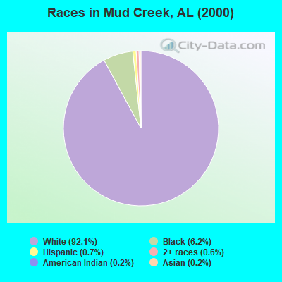
- 4,31292.1%White alone
- 2896.2%Black alone
- 350.7%Hispanic
- 290.6%Two or more races
- 110.2%American Indian alone
- 80.2%Asian alone
 Recent articles from our blog. Our writers, many of them Ph.D. graduates or candidates, create easy-to-read articles on a wide variety of topics.

Current Local Time: CST time zone
Elevation: 400 feet
Land area: 143.6 square miles.
Population density: 33 people per square mile (very low).

| Mud Creek CCD: | 0.3% ($199) |
| Alabama: | 0.4% ($289) |
Nearest city with pop. 50,000+: Marietta, GA  (56.2 miles , pop. 58,748).
Nearest city with pop. 200,000+: Atlanta, GA (67.3 miles , pop. 416,474).
Nearest city with pop. 1,000,000+: Chicago, IL (549.2 miles , pop. 2,896,016).
Nearest cities:
), Latitude: 34.09 N, Longitude: 85.51 W

| Here: | 2.6% |
| Alabama: | 2.6% |
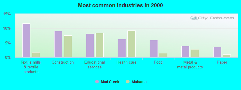
- Textile mills & textile products (11.7%)
- Construction (9.1%)
- Educational services (8.1%)
- Health care (6.3%)
- Food (6.0%)
- Metal & metal products (3.9%)
- Paper (3.6%)

- Construction (15.0%)
- Textile mills & textile products (10.2%)
- Metal & metal products (5.7%)
- Paper (5.2%)
- Educational services (5.0%)
- Administrative & support & waste management services (4.1%)
- Furniture & related product manufacturing (3.9%)

- Textile mills & textile products (13.7%)
- Educational services (12.4%)
- Health care (11.7%)
- Food (9.0%)
- Finance & insurance (5.8%)
- Social assistance (4.8%)
- Miscellaneous manufacturing (3.5%)

- Other production occupations, including supervisors (9.7%)
- Textile, apparel, and furnishings workers (5.9%)
- Laborers and material movers, hand (4.9%)
- Registered nurses (4.0%)
- Metal workers and plastic workers (3.4%)
- Driver/sales workers and truck drivers (3.4%)
- Building and grounds cleaning and maintenance occupations (3.3%)

- Other production occupations, including supervisors (11.6%)
- Metal workers and plastic workers (5.9%)
- Driver/sales workers and truck drivers (5.9%)
- Construction traders workers except carpenters, electricians, painters, plumbers, and construction laborers (5.0%)
- Laborers and material movers, hand (4.5%)
- Building and grounds cleaning and maintenance occupations (4.4%)
- Other management occupations, except farmers and farm managers (4.2%)

- Textile, apparel, and furnishings workers (8.4%)
- Other production occupations, including supervisors (7.2%)
- Registered nurses (7.2%)
- Laborers and material movers, hand (5.5%)
- Preschool, kindergarten, elementary, and middle school teachers (5.2%)
- Financial clerks, except bookkeeping, accounting and auditing clerks (4.7%)
- Customer service representatives (4.4%)
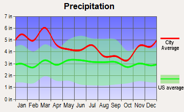
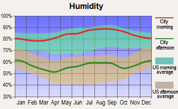
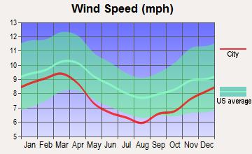
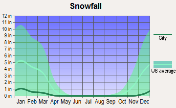
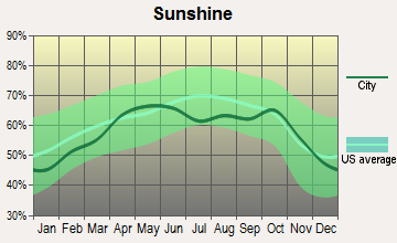
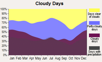
Average climate in Mud Creek, Alabama
Based on data reported by over 4,000 weather stations
(lower is better)
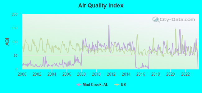
Air Quality Index (AQI) level in 2023 was 75.9. This is about average.
| City: | 75.9 |
| U.S.: | 72.6 |
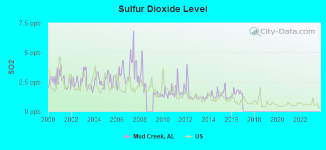
Sulfur Dioxide (SO2) [ppb] level in 2016 was 1.61. This is about average. Closest monitor was 16.0 miles away from the city center.
| City: | 1.61 |
| U.S.: | 1.51 |
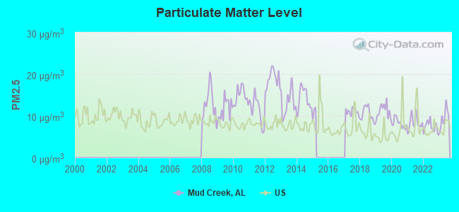
Particulate Matter (PM2.5) [µg/m3] level in 2023 was 9.39. This is about average. Closest monitor was 16.0 miles away from the city center.
| City: | 9.39 |
| U.S.: | 8.11 |
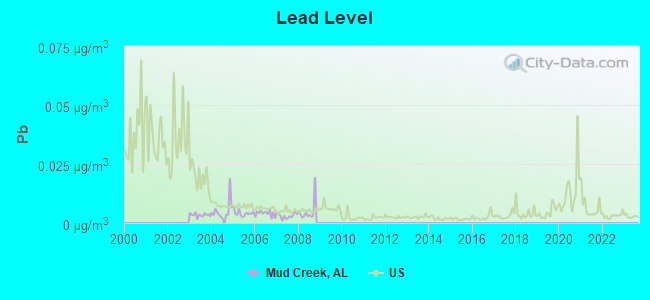
Lead (Pb) [µg/m3] level in 2008 was 0.00488. This is significantly better than average. Closest monitor was 22.3 miles away from the city center.
| City: | 0.00488 |
| U.S.: | 0.00931 |
Tornado activity:
Mud Creek-area historical tornado activity is slightly above Alabama state average. It is 117% greater than the overall U.S. average.
On 3/27/1994, a category F4 (max. wind speeds 207-260 mph) tornado 6.8 miles away from the Mud Creek place center killed 22 people and injured 150 people and caused between $5,000,000 and $50,000,000 in damages.
On 3/27/1994, a category F4 tornado 27.5 miles away from the place center killed 3 people and injured 20 people and caused between $5,000,000 and $50,000,000 in damages.
Earthquake activity:
Mud Creek-area historical earthquake activity is significantly above Alabama state average. It is 100% greater than the overall U.S. average.On 4/29/2003 at 08:59:39, a magnitude 4.9 (4.4 MB, 4.6 MW, 4.9 LG, Class: Light, Intensity: IV - V) earthquake occurred 29.1 miles away from Mud Creek center
On 4/29/2003 at 08:59:39, a magnitude 4.6 (4.6 MW, Depth: 12.3 mi) earthquake occurred 29.1 miles away from Mud Creek center
On 1/18/1999 at 07:00:53, a magnitude 4.8 (4.8 MB, 4.0 LG, Depth: 0.6 mi) earthquake occurred 111.0 miles away from the city center
On 8/2/1974 at 08:52:09, a magnitude 4.9 (4.3 MB, 4.9 LG) earthquake occurred 173.8 miles away from Mud Creek center
On 11/30/1973 at 07:48:41, a magnitude 4.7 (4.7 MB, 4.6 ML) earthquake occurred 147.3 miles away from the city center
On 12/12/2018 at 09:14:43, a magnitude 4.4 (4.4 MW, Depth: 4.9 mi) earthquake occurred 114.4 miles away from the city center
Magnitude types: regional Lg-wave magnitude (LG), body-wave magnitude (MB), local magnitude (ML), moment magnitude (MW)
Natural disasters:
The number of natural disasters in Cherokee County (21) is greater than the US average (15).Major Disasters (Presidential) Declared: 12
Emergencies Declared: 5
Causes of natural disasters: Tornadoes: 11, Storms: 9, Floods: 6, Hurricanes: 5, Winds: 4, Winter Storms: 2, Drought: 1, Fire: 1, Snowfall: 1, Other: 1 (Note: some incidents may be assigned to more than one category).
Hospitals and medical centers near Mud Creek:
- CHEROKEE COMMUNITY HOSPICE (Hospital, about 10 miles away; CENTRE, AL)
- CHEROKEE MEDICAL CENTER Acute Care Hospitals (about 10 miles away; CENTRE, AL)
- CHEROKEE COUNTY HEALTH AND REHABILITATION CENTER (Nursing Home, about 11 miles away; CENTRE, AL)
- CHEROKEE HOME HEALTH (Home Health Center, about 12 miles away; CENTRE, AL)
- PIEDMONT HOSPITAL (Hospital, about 14 miles away; PIEDMONT, AL)
- PIEDMONT HEALTH CARE CENTER (Nursing Home, about 14 miles away; PIEDMONT, AL)
- CEDARTOWN DIALYSIS (Dialysis Facility, about 16 miles away; CEDARTOWN, GA)
Colleges/universities with over 2000 students nearest to Mud Creek:
- Georgia Highlands College (about 19 miles; Rome, GA; Full-time enrollment: 4,071)
- Georgia Northwestern Technical College (about 22 miles; Rome, GA; FT enrollment: 4,629)
- Berry College (about 23 miles; Mount Berry, GA; FT enrollment: 2,102)
- Jacksonville State University (about 24 miles; Jacksonville, AL; FT enrollment: 7,566)
- Gadsden State Community College (about 29 miles; Gadsden, AL; FT enrollment: 4,650)
- West Georgia Technical College (about 34 miles; Waco, GA; FT enrollment: 4,768)
- Snead State Community College (about 39 miles; Boaz, AL; FT enrollment: 2,023)
Points of interest:
Notable locations in Mud Creek: Rock Run Station (A), McCord Cross Roads Volunteer Fire Department (B), Spring Creek Volunteer Fire Department (C), Spring Garden Volunteer Fire Department (D). Display/hide their locations on the map
Churches in Mud Creek include: Mount Zion Church (A), Providence Baptist Church (B), New Bethel Church (C), New Prospect Church (D), Lebanon Campground Church (E), Salem Church (F), Noah Baptist Church (G), Christian Mission Church (H), Bethel Church (I). Display/hide their locations on the map
Cemeteries: Howell Cemetery (1), Sheepskin Cemetery (2), Salem Cemetery (3), Providence Cemetery (4), Noah Cemetery (5), Lebanon Cemetery (6), Hopewell Cemetery (7). Display/hide their locations on the map
Lakes and reservoirs: Blue Pond (A), La Garde Lake (B), Terrapin Creek Lake Number 17 (C), McGee Lake (D), Norton Lake (E), Arrington Lakes (F), Lagarde Number 1 Lake (G), Arrington Lake Number 1 (H). Display/hide their locations on the map
Streams, rivers, and creeks: Strickland Branch (A), Spring Creek (B), Sandy Creek (C), Sal Brown Branch (D), Sat Brown Branch (E), Mud Creek (F), Lumpkin Mill Creek (G), Locust Branch (H), Bulse Branch (I). Display/hide their locations on the map
| This place: | 2.5 people |
| Alabama: | 2.5 people |
| This place: | 64.6% |
| Whole state: | 70.4% |
| This place: | 2.9% |
| Whole state: | 3.4% |
Likely homosexual households (counted as self-reported same-sex unmarried-partner households)
- Lesbian couples: 0.3% of all households
- Gay men: 0.4% of all households
| This place: | 9.7% |
| Whole state: | 16.1% |
| This place: | 5.3% |
| Whole state: | 7.3% |
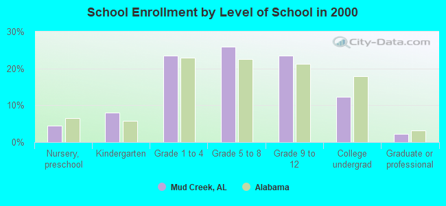
For population 15 years and over in Mud Creek:
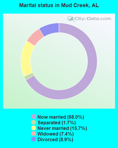
- Never married: 15.7%
- Now married: 68.0%
- Separated: 1.7%
- Widowed: 7.4%
- Divorced: 8.9%
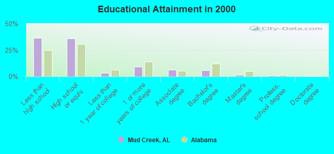
For population 25 years and over in Mud Creek:
- High school or higher: 63.4%
- Bachelor's degree or higher: 8.6%
- Graduate or professional degree: 2.9%
- Unemployed: 2.5%
- Mean travel time to work (commute): 35.6 minutes
| Here: | 14.3 |
| Alabama average: | 13.2 |


Graphs represent county-level data. Detailed 2008 Election Results
Religion statistics for Mud Creek, AL (based on Cherokee County data)
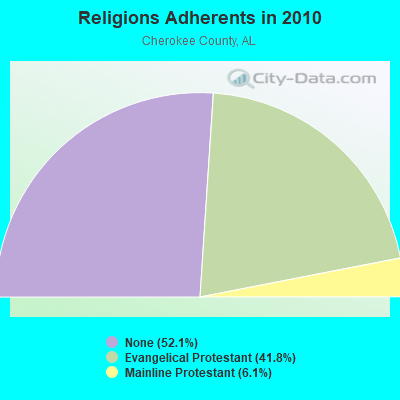
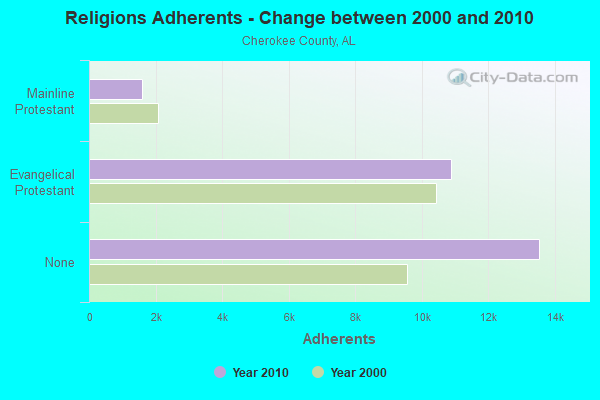
| Religion | Adherents | Congregations |
|---|---|---|
| Evangelical Protestant | 10,865 | 62 |
| Mainline Protestant | 1,590 | 16 |
| Other | - | 1 |
| None | 13,534 | - |
Food Environment Statistics:
| Cherokee County: | 1.63 / 10,000 pop. |
| Alabama: | 1.89 / 10,000 pop. |
| Here: | 0.41 / 10,000 pop. |
| Alabama: | 0.20 / 10,000 pop. |
| Cherokee County: | 5.71 / 10,000 pop. |
| Alabama: | 6.32 / 10,000 pop. |
| Cherokee County: | 5.71 / 10,000 pop. |
| Alabama: | 5.75 / 10,000 pop. |
| Cherokee County: | 13.3% |
| State: | 11.8% |
| This county: | 30.7% |
| State: | 31.7% |
| Here: | 14.3% |
| Alabama: | 13.5% |
Strongest AM radio stations in Mud Creek:
- WNSI (810 AM; 50 kW; JACKSONVILLE, AL; Owner: UNITED BROADCASTING NETWORK, INC.)
- WKNG (1060 AM; daytime; 50 kW; TALLAPOOSA, GA; Owner: WKNG, INC.)
- WFTD (1080 AM; daytime; 50 kW; MARIETTA, GA; Owner: PRIETO ENTERPRISES, INC.)
- WGST (640 AM; 50 kW; ATLANTA, GA; Owner: CITICASTERS LICENSES, L.P.)
- WMLB (1160 AM; 50 kW; EAST POINT, GA; Owner: ATLANTA AREA BROADCASTING, INC.)
- WCNN (680 AM; 50 kW; NORTH ATLANTA, GA; Owner: DICKEY BROADCASTING COMPANY)
- WWAM (820 AM; daytime; 50 kW; JASPER, TN; Owner: SHELTON BROADCASTING SYSTEM)
- WSB (750 AM; 50 kW; ATLANTA, GA; Owner: CXR HOLDINGS, INC.)
- WFLI (1070 AM; 50 kW; LOOKOUT MOUNTAIN, TN; Owner: WFLI, INC.)
- WQRX (870 AM; daytime; 10 kW; VALLEY HEAD, AL; Owner: BARINOWSKI INVESTMENT COMPANY)
- WZTQ (1560 AM; daytime; 1 kW; CENTRE, AL; Owner: RADIO CENTRE, INC.)
- WAZX (1550 AM; 50 kW; SMYRNA, GA; Owner: GA-MEX BROADCASTING, INC.)
- WAAX (570 AM; 5 kW; GADSDEN, AL; Owner: CAPSTAR TX LIMITED PARTNERSHIP)
Strongest FM radio stations in Mud Creek:
- WRHY (105.9 FM; CENTRE, AL; Owner: WILLIAMS COMMUNICATIONS, INC.)
- WJCK (88.3 FM; PIEDMONT, AL; Owner: IMMANUEL BROADCASTING NETWORK, INC.)
- W215BA (90.9 FM; ROME, GA; Owner: PENSACOLA CHRISTIAN COLLEGE, INC.)
- WLJS-FM (91.9 FM; JACKSONVILLE, AL; Owner: BD. OF TRUSTEES/JACKSONVILLE STATE UNIVERSITY)
- WKCX (97.7 FM; ROME, GA; Owner: BRIAR CREEK BROADCASTING CORP.)
- WQTU (102.3 FM; ROME, GA; Owner: MCDOUGALD BROADCASTING CORPORATION)
- W212AR (90.3 FM; LINDALE, GA; Owner: WAY-FM MEDIA GROUP, INC.)
- WTBJ (91.3 FM; OXFORD, AL; Owner: TRINITY CHRISTIAN ACADEMY)
- WQSB (105.1 FM; ALBERTVILLE, AL; Owner: SAND MOUNTAIN BROADCASTING SERVICE, INC.)
- WGMZ (93.1 FM; GLENCOE, AL; Owner: CAPSTAR TX LIMITED PARTNERSHIP)
- WCKS (102.7 FM; FRUITHURST, AL; Owner: WCKS, INC.)
- WVOK-FM (97.9 FM; OXFORD, AL; Owner: WOODARD BROADCASTING CO. INC.)
- WATG (95.7 FM; TRION, GA; Owner: TTA BROADCASTING, INC)
- WMAX-FM (105.3 FM; BOWDON, GA; Owner: CLEAR CHANNEL BROADCASTING LICENSES, INC.)
- W214AS (90.7 FM; WALESKA, GA; Owner: CALVARY CHAPEL OF TWIN FALLS, INC.)
- W221AW (92.1 FM; NORTH CANTON, GA; Owner: IMMANUEL BROADCASTING NETWORK, INC.)
- WTBB (89.9 FM; GADSDEN, AL; Owner: TRINITY CHRISTIAN ACADEMY)
- WSGN (91.5 FM; GADSDEN, AL; Owner: GADSDEN STATE COMMUNITY COLLEGE)
- WTSH-FM (107.1 FM; ROCKMART, GA; Owner: BROADCAST INVESTMENT ASSOCIATES, INC)
TV broadcast stations around Mud Creek:
- WPXH (Channel 44; GADSDEN, AL; Owner: PAXSON COMMUNICATIONS LICENSE COMPANY, LLC)
- National Bridge Inventory (NBI) Statistics
- 5Number of bridges
- 52ft / 16.2mTotal length
- $7,716,000Total costs
- 25,647Total average daily traffic
- 3,007Total average daily truck traffic
- 35,193Total future (year 2035) average daily traffic
FCC Registered Antenna Towers:
11 (See the full list of FCC Registered Antenna Towers in Mud Creek)FCC Registered Microwave Towers:
1- BH1011-HANCEVILLE, 956 County Rd 574 (Lat: 34.075139 Lon: -86.811417), Type: Tower, Structure height: 77.7 m, Overall height: 79.2 m, Call Sign: WPZS444,
Assigned Frequencies: 19430.0 MHz, Grant Date: 04/29/2014, Expiration Date: 03/03/2024, Cancellation Date: 01/31/2018, Certifier: Dan Menser, Registrant: T-Mobile License LLC, 12920 Se38th St, Bellevue, WA 98006, Phone: (425) 383-8401, Email:
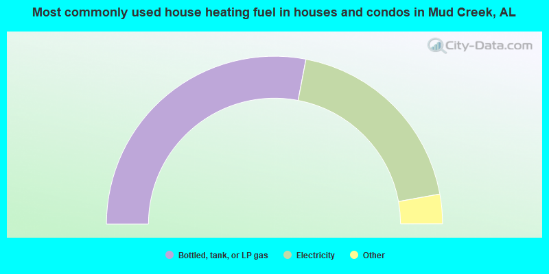
- 56.0%Bottled, tank, or LP gas
- 38.3%Electricity
- 2.9%Utility gas
- 2.9%Wood
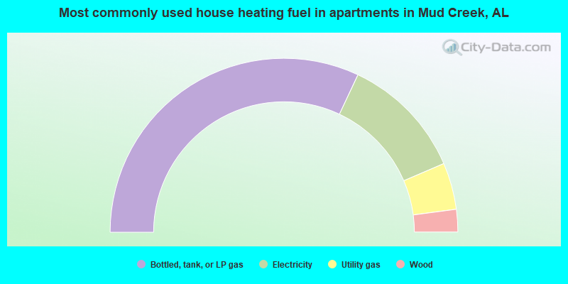
- 64.0%Bottled, tank, or LP gas
- 23.1%Electricity
- 8.7%Utility gas
- 4.2%Wood
Mud Creek compared to Alabama state average:
- Unemployed percentage significantly below state average.
- Black race population percentage significantly below state average.
- Hispanic race population percentage significantly below state average.
- Median age below state average.
- Foreign-born population percentage significantly below state average.
- Renting percentage significantly below state average.
- Length of stay since moving in significantly above state average.
- Number of rooms per house significantly below state average.
- House age significantly below state average.
- Percentage of population with a bachelor's degree or higher significantly below state average.
Mud Creek on our top lists:
- #83 on the list of "Top 101 larger cities with the lowest real estate taxes percentage (population 50,000+)"
- #68 (35960) on the list of "Top 101 zip codes with the largest percentage of taxpayers using paid preparers for 2012 taxes (pop 5,000+)"