Monfort Heights South, Ohio
Submit your own pictures of this place and show them to the world
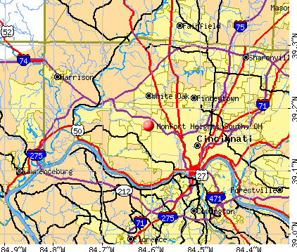
- OSM Map
- General Map
- Google Map
- MSN Map
| Males: 2,253 | |
| Females: 2,274 |
| Median resident age: | 39.8 years |
| Ohio median age: | 36.2 years |
Zip codes: 45211.
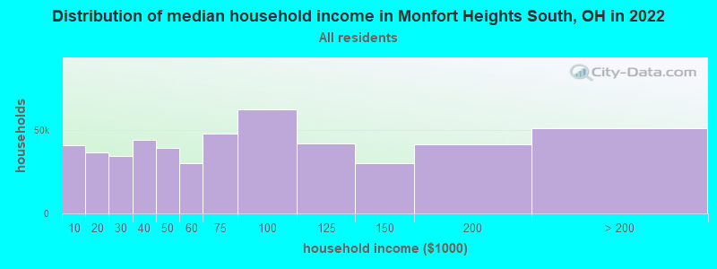
| Monfort Heights South: | $93,844 |
| OH: | $65,720 |
Estimated per capita income in 2022: $52,865 (it was $29,839 in 2000)
Monfort Heights South CDP income, earnings, and wages data
Estimated median house or condo value in 2022: $257,644 (it was $119,300 in 2000)
| Monfort Heights South: | $257,644 |
| OH: | $204,100 |
Mean prices in 2022: all housing units: $287,234; detached houses: $296,893; townhouses or other attached units: $235,250; in 2-unit structures: $170,513; in 3-to-4-unit structures: $209,651; in 5-or-more-unit structures: $251,242; mobile homes: $23,054; occupied boats, rvs, vans, etc.: $119,122
Monfort Heights South, OH residents, houses, and apartments details
Detailed information about poverty and poor residents in Monfort Heights South, OH
Compare current foreclosures near Monfort Heights South, OH:


- 4,34797.3%White alone
- 320.7%Black alone
- 310.7%Two or more races
- 270.6%Asian alone
- 230.5%Hispanic
- 50.1%American Indian alone
- 10.02%Other race alone
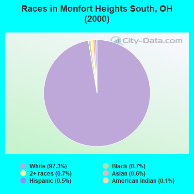
Races in Monfort Heights South detailed stats: ancestries, foreign born residents, place of birth
 Recent articles from our blog. Our writers, many of them Ph.D. graduates or candidates, create easy-to-read articles on a wide variety of topics.


Ancestries: German (53.7%), Irish (17.7%), English (11.8%), United States (11.7%), Italian (6.8%), French (3.0%).
Current Local Time: EST time zone
Land area: 3.11 square miles.
Population density: 1,457 people per square mile (low).
86 residents are foreign born
| This place: | 1.9% |
| Ohio: | 3.0% |
| Monfort Heights South CDP: | 1.4% ($1,624) |
| Ohio: | 1.3% ($1,271) |
Nearest city with pop. 50,000+: Cincinnati, OH  (6.1 miles , pop. 331,285).
Nearest city with pop. 1,000,000+: Chicago, IL (245.3 miles , pop. 2,896,016).
Nearest cities:
), ), ), ), ), ), )Latitude: 39.17 N, Longitude: 84.61 W
Property values in Monfort Heights South, OH
| Here: | 2.8% |
| Ohio: | 3.1% |

- Health care (11.7%)
- Construction (8.8%)
- Professional, scientific, technical services (7.5%)
- Finance & insurance (6.8%)
- Accommodation & food services (6.7%)
- Educational services (4.8%)
- Food & beverage stores (4.6%)
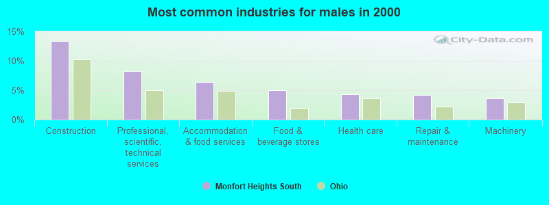
- Construction (13.4%)
- Professional, scientific, technical services (8.2%)
- Accommodation & food services (6.4%)
- Food & beverage stores (5.1%)
- Health care (4.3%)
- Repair & maintenance (4.2%)
- Machinery (3.6%)
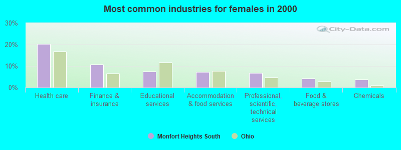
- Health care (20.2%)
- Finance & insurance (10.7%)
- Educational services (7.4%)
- Accommodation & food services (7.1%)
- Professional, scientific, technical services (6.7%)
- Food & beverage stores (4.1%)
- Chemicals (3.8%)
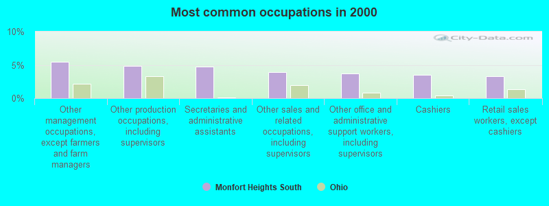
- Other management occupations, except farmers and farm managers (5.4%)
- Other production occupations, including supervisors (4.9%)
- Secretaries and administrative assistants (4.7%)
- Other sales and related occupations, including supervisors (3.9%)
- Other office and administrative support workers, including supervisors (3.7%)
- Cashiers (3.5%)
- Retail sales workers, except cashiers (3.3%)
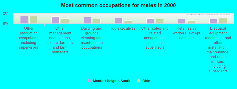
- Other production occupations, including supervisors (6.4%)
- Other management occupations, except farmers and farm managers (5.8%)
- Building and grounds cleaning and maintenance occupations (5.3%)
- Top executives (4.6%)
- Other sales and related occupations, including supervisors (4.1%)
- Retail sales workers, except cashiers (4.0%)
- Electrical equipment mechanics and other installation, maintenance, and repair workers, including supervisors (3.7%)

- Secretaries and administrative assistants (10.0%)
- Cashiers (6.9%)
- Other office and administrative support workers, including supervisors (5.6%)
- Other management occupations, except farmers and farm managers (5.1%)
- Information and record clerks, except customer service representatives (4.7%)
- Registered nurses (4.5%)
- Other sales and related occupations, including supervisors (3.7%)
Average climate in Monfort Heights South, Ohio
Based on data reported by over 4,000 weather stations


(lower is better)
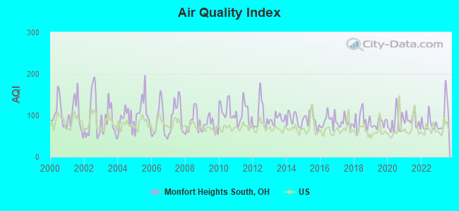
Air Quality Index (AQI) level in 2023 was 100. This is worse than average.
| City: | 100 |
| U.S.: | 73 |
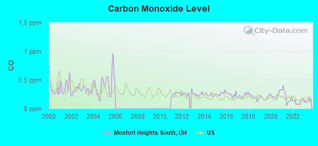
Carbon Monoxide (CO) [ppm] level in 2023 was 0.138. This is significantly better than average. Closest monitor was 5.4 miles away from the city center.
| City: | 0.138 |
| U.S.: | 0.251 |
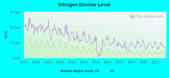
Nitrogen Dioxide (NO2) [ppb] level in 2023 was 7.66. This is significantly worse than average. Closest monitor was 1.2 miles away from the city center.
| City: | 7.66 |
| U.S.: | 5.11 |
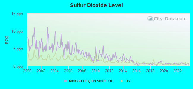
Sulfur Dioxide (SO2) [ppb] level in 2023 was 0.563. This is significantly better than average. Closest monitor was 1.2 miles away from the city center.
| City: | 0.563 |
| U.S.: | 1.515 |
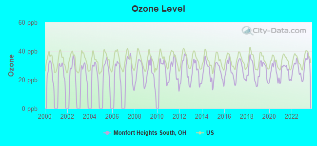
Ozone [ppb] level in 2023 was 31.8. This is about average. Closest monitor was 5.4 miles away from the city center.
| City: | 31.8 |
| U.S.: | 33.3 |
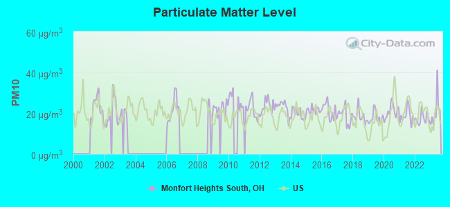
Particulate Matter (PM10) [µg/m3] level in 2023 was 21.0. This is about average. Closest monitor was 5.4 miles away from the city center.
| City: | 21.0 |
| U.S.: | 19.2 |
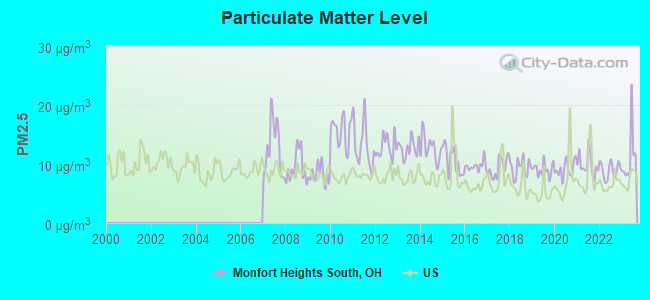
Particulate Matter (PM2.5) [µg/m3] level in 2023 was 11.1. This is worse than average. Closest monitor was 4.1 miles away from the city center.
| City: | 11.1 |
| U.S.: | 8.1 |
Tornado activity:
Monfort Heights South-area historical tornado activity is above Ohio state average. It is 73% greater than the overall U.S. average.
On 4/3/1974, a category F5 (max. wind speeds 261-318 mph) tornado 3.6 miles away from the Monfort Heights South place center killed 3 people and injured 210 people.
On 4/3/1974, a category F4 (max. wind speeds 207-260 mph) tornado 6.8 miles away from the place center killed 2 people and injured 39 people and caused between $50,000 and $500,000 in damages.
Earthquake activity:
Monfort Heights South-area historical earthquake activity is significantly above Ohio state average. It is 50% greater than the overall U.S. average.On 7/27/1980 at 18:52:21, a magnitude 5.2 (5.1 MB, 4.7 MS, 5.0 UK, 5.2 UK, Class: Moderate, Intensity: VI - VII) earthquake occurred 75.9 miles away from the city center
On 4/18/2008 at 09:36:59, a magnitude 5.4 (5.1 MB, 4.8 MS, 5.4 MW, 5.2 MW) earthquake occurred 183.6 miles away from the city center
On 4/18/2008 at 09:36:59, a magnitude 5.2 (5.2 MW, Depth: 8.9 mi) earthquake occurred 183.6 miles away from the city center
On 6/10/1987 at 23:48:54, a magnitude 5.1 (4.9 MB, 4.4 MS, 4.6 MS, 5.1 LG) earthquake occurred 177.9 miles away from Monfort Heights South center
On 9/7/1988 at 02:28:09, a magnitude 4.6 (4.5 MB, 4.6 LG, Class: Light, Intensity: IV - V) earthquake occurred 81.3 miles away from Monfort Heights South center
On 6/18/2002 at 17:37:15, a magnitude 5.0 (4.3 MB, 4.6 MW, 5.0 LG) earthquake occurred 190.2 miles away from the city center
Magnitude types: regional Lg-wave magnitude (LG), body-wave magnitude (MB), surface-wave magnitude (MS), moment magnitude (MW)
Natural disasters:
The number of natural disasters in Hamilton County (15) is near the US average (15).Major Disasters (Presidential) Declared: 10
Emergencies Declared: 3
Causes of natural disasters: Floods: 7, Storms: 7, Mudslides: 2, Tornadoes: 2, Blizzard: 1, Heavy Rain: 1, Hurricane: 1, Landslide: 1, Snow: 1, Snowstorm: 1, Tropical Depression: 1, Wind: 1, Other: 1 (Note: some incidents may be assigned to more than one category).
Hospitals and medical centers near Monfort Heights South:
- WESTSIDE REGIONAL MEDICAL CENTER (Hospital, about 1 miles away; CINCINNATI, OH)
- TERRACE VIEW GARDENS (Nursing Home, about 1 miles away; CINCINNATI, OH)
- OAK HILLS NURSING AND REHAB (Nursing Home, about 2 miles away; CHEVIOT, OH)
- HILLEBRAND NURSING AND REHABILITATION CENTER (Nursing Home, about 2 miles away; CINCINNATI, OH)
- HILLEBRAND HOME HEALTH, INC (Home Health Center, about 2 miles away; CINCINNATI, OH)
- DAVITA - WHITE OAK HOME DIALYSIS (Dialysis Facility, about 2 miles away; CINCINNATI, OH)
- WHITE OAK DIALYSIS (Dialysis Facility, about 2 miles away; CINCINNATI, OH)
Amtrak stations near Monfort Heights South:
- 7 miles: CINCINNATI (1301 WESTERN AVE.) . Services: ticket office, fully wheelchair accessible, enclosed waiting area, public restrooms, public payphones, full-service food facilities, free short-term parking, paid long-term parking, taxi stand.
- 16 miles: HAMILTON (M. L. KING BLVD AT HENRY ST.) . Services: public payphones, free short-term parking, call for taxi service, public transit connection.
Colleges/universities with over 2000 students nearest to Monfort Heights South:
- Cincinnati State Technical and Community College (about 5 miles; Cincinnati, OH; Full-time enrollment: 8,757)
- College of Mount St Joseph (about 6 miles; Cincinnati, OH; FT enrollment: 2,073)
- University of Cincinnati-Main Campus (about 6 miles; Cincinnati, OH; FT enrollment: 28,747)
- Xavier University (about 8 miles; Cincinnati, OH; FT enrollment: 6,143)
- University of Cincinnati-Blue Ash College (about 12 miles; Blue Ash, OH; FT enrollment: 3,711)
- Northern Kentucky University (about 13 miles; Highland Heights, KY; FT enrollment: 12,059)
- Miami University-Hamilton (about 15 miles; Hamilton, OH; FT enrollment: 2,906)
Points of interest:
Church in Monfort Heights South: Saint Ignatius Loyola Catholic Church (A). Display/hide its location on the map
Reservoir: Dream Valley Lake (A). Display/hide its location on the map
| This place: | 2.7 people |
| Ohio: | 2.5 people |
| This place: | 78.0% |
| Whole state: | 67.6% |
| This place: | 2.5% |
| Whole state: | 5.2% |
Likely homosexual households (counted as self-reported same-sex unmarried-partner households)
- Lesbian couples: 0.2% of all households
- Gay men: 0.2% of all households
| This place: | 5.6% |
| Whole state: | 10.6% |
| This place: | 0.5% |
| Whole state: | 4.8% |
For population 15 years and over in Monfort Heights South:
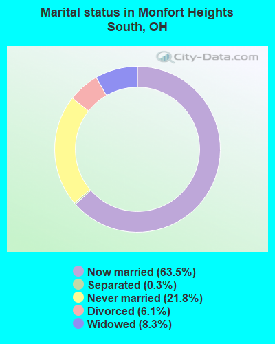
- Never married: 21.8%
- Now married: 63.5%
- Separated: 0.3%
- Widowed: 8.3%
- Divorced: 6.1%
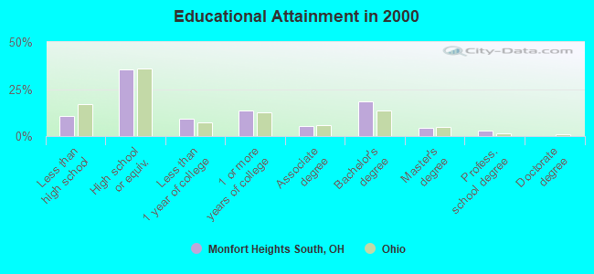
For population 25 years and over in Monfort Heights South:
- High school or higher: 89.5%
- Bachelor's degree or higher: 25.8%
- Graduate or professional degree: 7.2%
- Unemployed: 1.0%
- Mean travel time to work (commute): 23.1 minutes
| Here: | 9.5 |
| Ohio average: | 11.0 |
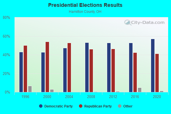
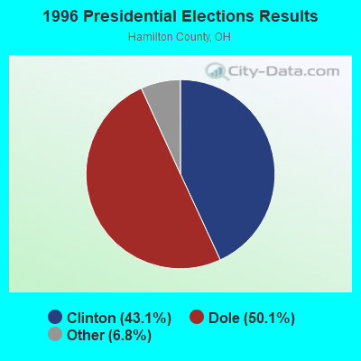
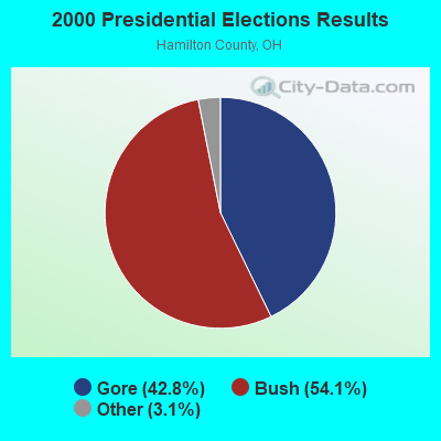
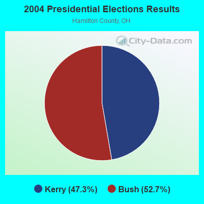
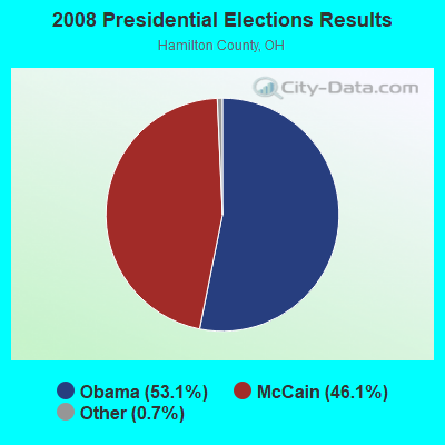
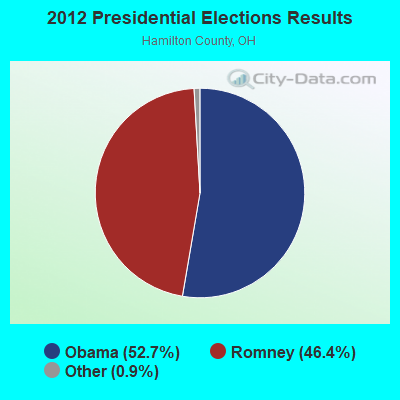
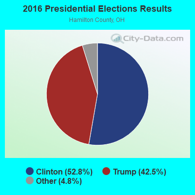
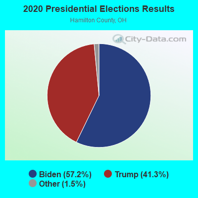
Graphs represent county-level data. Detailed 2008 Election Results
Religion statistics for Monfort Heights South, OH (based on Hamilton County data)
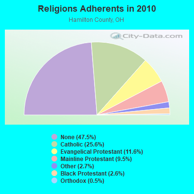
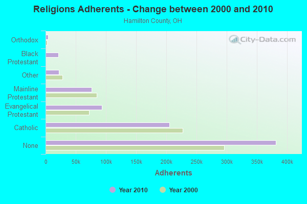
| Religion | Adherents | Congregations |
|---|---|---|
| Catholic | 205,094 | 83 |
| Evangelical Protestant | 93,166 | 269 |
| Mainline Protestant | 76,354 | 188 |
| Other | 21,699 | 64 |
| Black Protestant | 20,814 | 55 |
| Orthodox | 3,879 | 7 |
| None | 381,368 | - |
Food Environment Statistics:
| Here: | 1.82 / 10,000 pop. |
| Ohio: | 1.89 / 10,000 pop. |
| Hamilton County: | 0.12 / 10,000 pop. |
| State: | 0.13 / 10,000 pop. |
| Hamilton County: | 1.49 / 10,000 pop. |
| Ohio: | 1.25 / 10,000 pop. |
| Hamilton County: | 2.66 / 10,000 pop. |
| Ohio: | 2.93 / 10,000 pop. |
| Here: | 7.48 / 10,000 pop. |
| Ohio: | 6.25 / 10,000 pop. |
| This county: | 9.8% |
| Ohio: | 10.3% |
| Here: | 26.6% |
| Ohio: | 29.1% |
| This county: | 11.7% |
| Ohio: | 11.9% |
5.24% of this county's 2021 resident taxpayers lived in other counties in 2020 ($68,039 average adjusted gross income)
| Here: | 5.24% |
| Ohio average: | 5.68% |
0.01% of residents moved from foreign countries ($43 average AGI)
Hamilton County: 0.01% Ohio average: 0.01%
Top counties from which taxpayers relocated into this county between 2020 and 2021:
| from Butler County, OH | |
| from Clermont County, OH | |
| from Warren County, OH |
6.26% of this county's 2020 resident taxpayers moved to other counties in 2021 ($83,260 average adjusted gross income)
| Here: | 6.26% |
| Ohio average: | 5.79% |
0.01% of residents moved to foreign countries ($86 average AGI)
Hamilton County: 0.01% Ohio average: 0.01%
Top counties to which taxpayers relocated from this county between 2020 and 2021:
| to Butler County, OH | |
| to Clermont County, OH | |
| to Warren County, OH |
Strongest AM radio stations in Monfort Heights South:
- WSAI (1530 AM; 50 kW; CINCINNATI, OH; Owner: JACOR BROADCASTING CORPORATION)
- WLW (700 AM; 50 kW; CINCINNATI, OH; Owner: JACOR BROADCASTING CORPORATION)
- WCKY (1360 AM; 5 kW; CINCINNATI, OH; Owner: JACOR BROADCASTING CORPORATION)
- WCIN (1480 AM; 5 kW; CINCINNATI, OH)
- WNOP (740 AM; 1 kW; NEWPORT, KY; Owner: SACRED HEART RADIO, INC.)
- WKRC (550 AM; 5 kW; CINCINNATI, OH; Owner: JACOR BROADCASTING CORPORATION)
- WCNW (1560 AM; daytime; 5 kW; FAIRFIELD, OH)
- WBOB (1160 AM; 5 kW; FLORENCE, KY; Owner: CARON BROADCASTING, INC.)
- WTSJ (1050 AM; 1 kW; CINCINNATI, OH; Owner: CARON BROADCASTING, INC.)
- WDBZ (1230 AM; 1 kW; CINCINNATI, OH; Owner: BLUE CHIP COMMUNICATIONS, INC.)
- WHAS (840 AM; 50 kW; LOUISVILLE, KY; Owner: CLEAR CHANNEL BROADCASTING LICENSES, INC.)
- WTVN (610 AM; 50 kW; COLUMBUS, OH; Owner: CITICASTERS LICENSES, L.P.)
- WIBC (1070 AM; 50 kW; INDIANAPOLIS, IN; Owner: EMMIS RADIO LICENSE CORPORATION)
Strongest FM radio stations in Monfort Heights South:
- WGRR (103.5 FM; HAMILTON, OH; Owner: INFINITY RADIO OPERATIONS INC.)
- WOFX-FM (92.5 FM; CINCINNATI, OH; Owner: JACOR BROADCASTING CORPORATION)
- WRRM (98.5 FM; CINCINNATI, OH; Owner: WRRM LICO, INC)
- WEBN (102.7 FM; CINCINNATI, OH; Owner: JACOR BROADCASTING CORPORATION)
- WVMX (94.1 FM; CINCINNATI, OH; Owner: CITICASTERS LICENSES, L.P.)
- WAKW (93.3 FM; CINCINNATI, OH; Owner: PILLAR OF FIRE)
- WGUC (90.9 FM; CINCINNATI, OH; Owner: CINCINNATI CLASSICAL PUBLIC RADIO, INC.)
- WUBE-FM (105.1 FM; CINCINNATI, OH; Owner: INFINITY RADIO OPERATIONS INC.)
- WKRQ (101.9 FM; CINCINNATI, OH; Owner: INFINITY RADIO OPERATIONS INC.)
- WKFS (107.1 FM; MILFORD, OH; Owner: JACOR BROADCASTING CORPORATION)
- WVXU (91.7 FM; CINCINNATI, OH; Owner: XAVIER UNIVERSITY)
- WIZF (100.9 FM; ERLANGER, KY; Owner: BLUE CHIP BROADCASTING LICENSES II, LTD.)
- WMOJ (94.9 FM; FAIRFIELD, OH; Owner: WVAE LICO, INC.)
- WAIF (88.3 FM; CINCINNATI, OH; Owner: STEPCHILD RADIO OF CINCINNATI, INC.)
- WYGY (96.5 FM; LEBANON, OH; Owner: WVAE LICO, INC.)
- WNLT (104.3 FM; HARRISON, OH; Owner: VERNON R. BALDWIN, INC.)
- WNKU (89.7 FM; HIGHLAND HEIGHTS, KY; Owner: BD. OF REGENTS ON N. KY UNIV.)
- WMKV (89.3 FM; READING, OH; Owner: LIFESPHERE)
- WJYC (90.1 FM; DELHI HILLS, OH; Owner: LIFETALK RADIO, INC.)
- WLHS (89.9 FM; WEST CHESTER, OH; Owner: LAKOTA LOCAL SCHOOL DISTRICT)
TV broadcast stations around Monfort Heights South:
- WXIX-TV (Channel 19; NEWPORT, KY; Owner: RAYCOM NATIONAL, INC.)
- WLWT (Channel 5; CINCINNATI, OH; Owner: OHIO/OKLAHOMA HEARST-ARGYLE TV, INC)
- WSTR-TV (Channel 64; CINCINNATI, OH; Owner: WSTR LICENSEE, INC.)
- WCET (Channel 48; CINCINNATI, OH; Owner: THE GREATER CINCINNATI TV EDUC'L. FOUNDATION)
- WCPO-TV (Channel 9; CINCINNATI, OH; Owner: SCRIPPS HOWARD BROADCASTING COMPANY)
- WKRC-TV (Channel 12; CINCINNATI, OH; Owner: CITICASTERS CO.)
- WBQC-CA (Channel 25; CINCINNATI, OH; Owner: ELLIOTT B. BLOCK)
- WOTH-LP (Channel 35; CINCINNATI, OH; Owner: ELLIOTT B. BLOCK)
- WPTO (Channel 14; OXFORD, OH; Owner: GREATER DAYTON PUBLIC TELEVISION, INC.)
- WKOI (Channel 43; RICHMOND, IN; Owner: TRINITY BROADCASTING OF INDIANA, INC.)
- WCVN-TV (Channel 54; COVINGTON, KY; Owner: KENTUCKY AUTHORITY FOR EDUCATIONAL TV)
- WHIO-TV (Channel 7; DAYTON, OH; Owner: WHIO-TV HOLDINGS, INC.)
- WDTN (Channel 2; DAYTON, OH; Owner: WDTN BROADCASTING, LLC)
- WPTD (Channel 16; DAYTON, OH; Owner: GREATER DAYTON PUBLIC TV, INC.)
- WKEF (Channel 22; DAYTON, OH; Owner: WKEF LICENSEE L.P.)
- WRGT-TV (Channel 45; DAYTON, OH; Owner: WRGT LICENSEE, LLC)
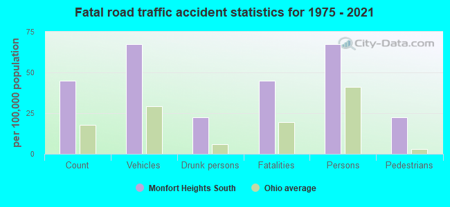
Monfort Heights South fatal accident list:
Aug 8, 2015 09:45 PM, Cr-142 North Bend Rd, Tr-61 Ridgewood Dr, Lat: 39.169789, Lon: -84.602631, Vehicles: 2, Persons: 2, Fatalities: 1, Drunk persons involved: 1
- National Bridge Inventory (NBI) Statistics
- 8Number of bridges
- 79ft / 23.8mTotal length
- 174,333Total average daily traffic
- 8,933Total average daily truck traffic
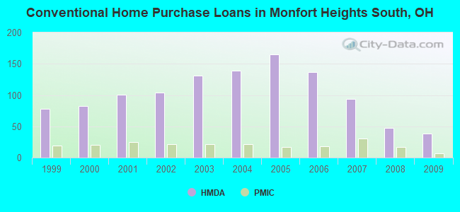
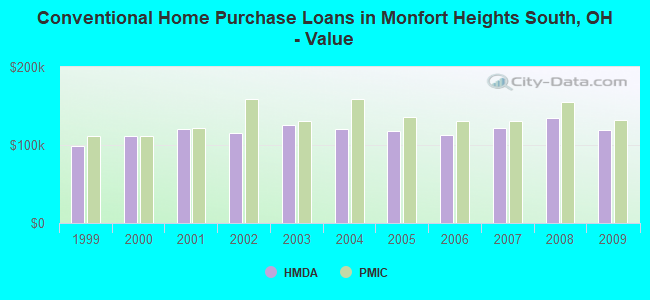
| Home Mortgage Disclosure Act Aggregated Statistics For Year 2009 (Based on 2 partial tracts) | ||||||||||
| A) FHA, FSA/RHS & VA Home Purchase Loans | B) Conventional Home Purchase Loans | C) Refinancings | D) Home Improvement Loans | F) Non-occupant Loans on < 5 Family Dwellings (A B C & D) | ||||||
|---|---|---|---|---|---|---|---|---|---|---|
| Number | Average Value | Number | Average Value | Number | Average Value | Number | Average Value | Number | Average Value | |
| LOANS ORIGINATED | 34 | $129,841 | 38 | $118,721 | 195 | $134,083 | 11 | $27,906 | 6 | $72,035 |
| APPLICATIONS APPROVED, NOT ACCEPTED | 1 | $126,150 | 2 | $120,450 | 11 | $126,875 | 2 | $11,975 | 3 | $68,410 |
| APPLICATIONS DENIED | 7 | $132,740 | 2 | $76,760 | 41 | $136,340 | 7 | $17,524 | 3 | $69,047 |
| APPLICATIONS WITHDRAWN | 2 | $116,200 | 1 | $80,580 | 18 | $149,481 | 2 | $12,020 | 1 | $77,740 |
| FILES CLOSED FOR INCOMPLETENESS | 1 | $56,290 | 0 | $0 | 4 | $105,352 | 0 | $0 | 0 | $0 |
Detailed HMDA statistics for the following Tracts: 0206.02 , 0208.02
| Private Mortgage Insurance Companies Aggregated Statistics For Year 2009 (Based on 2 partial tracts) | ||||
| A) Conventional Home Purchase Loans | B) Refinancings | |||
|---|---|---|---|---|
| Number | Average Value | Number | Average Value | |
| LOANS ORIGINATED | 7 | $131,670 | 3 | $169,330 |
| APPLICATIONS APPROVED, NOT ACCEPTED | 1 | $245,690 | 1 | $161,810 |
| APPLICATIONS DENIED | 1 | $227,490 | 2 | $181,175 |
| APPLICATIONS WITHDRAWN | 0 | $0 | 0 | $0 |
| FILES CLOSED FOR INCOMPLETENESS | 0 | $0 | 0 | $0 |
Detailed PMIC statistics for the following Tracts: 0206.02 , 0208.02
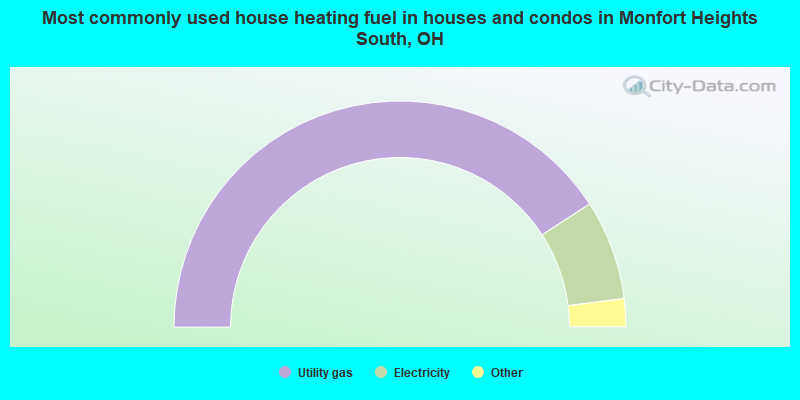
- 81.6%Utility gas
- 14.3%Electricity
- 2.8%Fuel oil, kerosene, etc.
- 1.2%Bottled, tank, or LP gas
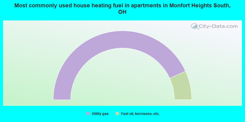
- 86.4%Utility gas
- 13.6%Fuel oil, kerosene, etc.
Monfort Heights South compared to Ohio state average:
- Unemployed percentage significantly below state average.
- Black race population percentage significantly below state average.
- Hispanic race population percentage significantly below state average.
- Foreign-born population percentage significantly below state average.
- Renting percentage significantly below state average.
- Length of stay since moving in significantly above state average.
- Number of rooms per house significantly below state average.
- House age significantly below state average.