Marysville Rural, California
Submit your own pictures of this place and show them to the world
- OSM Map
- General Map
- Google Map
- MSN Map

| Males: 3,683 | |
| Females: 3,678 |
| Median resident age: | 41.7 years |
| California median age: | 33.3 years |
Zip code: 95901
| Marysville Rural: | $91,489 |
| CA: | $91,551 |
Estimated per capita income in 2022: $50,316 (it was $21,891 in 2000)
Marysville Rural CCD income, earnings, and wages data
Estimated median house or condo value in 2022: $742,500 (it was $154,400 in 2000)
| Marysville Rural: | $742,500 |
| CA: | $715,900 |
Marysville Rural, CA residents, houses, and apartments details
Detailed information about poverty and poor residents in Marysville Rural, CA
Compare current foreclosures near Marysville Rural, CA:
| Photo | Address | Area | Beds / Baths | Price | Details |
|---|---|---|---|---|---|

|
#1
Claremont Dr
Oroville, CA 95966
|
2,031 sq. feet
|
2 baths 2 beds |
$450,000
|
show details |

|
#2
Oro Bangor Hwy
Oroville, CA 95966
|
1,304 sq. feet
|
2 baths 3 beds |
$218,900
|
show details |

|
#3
Mason Way
Oregon House, CA 95962
|
- sq. feet
|
2 baths 2 beds |
$187,200
|
show details |

|
#4
Black Bart Rd
Oroville, CA 95966
|
740 sq. feet
|
1 baths 1 beds |
show details | |

|
#5
Main St
Yuba City, CA 95991
|
1,308 sq. feet
|
2 baths 3 beds |
show details | |

|
#6
Fire Camp Rd
Oroville, CA 95966
|
1,872 sq. feet
|
2 baths 3 beds |
show details | |

|
#7
Rodeo Way
Olivehurst, CA 95961
|
1,319 sq. feet
|
2 baths 3 beds |
show details | |

|
#8
Arbor Dr
Yuba City, CA 95991
|
1,444 sq. feet
|
3 baths 3 beds |
show details | |

|
#9
Carlotta Way
Yuba City, CA 95991
|
2,040 sq. feet
|
3 baths 4 beds |
show details | |

|
#10
Heritage Way
Yuba City, CA 95991
|
2,048 sq. feet
|
3 baths 4 beds |
show details |
| Photo | Address | Area | Beds / Baths | Price | Details |
|---|---|---|---|---|---|

|
#11
Black Ct
Yuba City, CA 95991
|
1,549 sq. feet
|
2 baths 4 beds |
show details | |

|
#12
Irene Way
Live Oak, CA 95953
|
1,783 sq. feet
|
2 baths 3 beds |
show details | |

|
#13
River Bank Dr
Marysville, CA 95901
|
1,513 sq. feet
|
2 baths 2 beds |
show details | |

|
#14
Sebina Ct
Live Oak, CA 95953
|
1,264 sq. feet
|
2 baths 3 beds |
show details | |

|
#15
Stone Wood Loop
Marysville, CA 95901
|
2,059 sq. feet
|
3 baths 4 beds |
show details | |

|
#16
Diamond Pointe Way
Yuba City, CA 95991
|
2,951 sq. feet
|
3 baths 4 beds |
show details | |

|
#17
Florain Dr
Yuba City, CA 95993
|
2,461 sq. feet
|
3 baths 3 beds |
show details | |

|
#18
Twisted River Dr
Marysville, CA 95901
|
1,828 sq. feet
|
3 baths 4 beds |
show details | |

|
#19
Twisted River Dr
Marysville, CA 95901
|
1,828 sq. feet
|
3 baths 3 beds |
show details | |

|
#20
Kyri Ct
Olivehurst, CA 95961
|
1,635 sq. feet
|
2 baths 3 beds |
show details |
| Photo | Address | Area | Beds / Baths | Price | Details |
|---|---|---|---|---|---|

|
#21
Colusa Hwy
Yuba City, CA 95993
|
2,586 sq. feet
|
2 baths 4 beds |
show details | |

|
#22
Lone Tree Rd
Oroville, CA 95965
|
1,348 sq. feet
|
2 baths 3 beds |
show details | |

|
#23
Josephene Way
Yuba City, CA 95993
|
2,004 sq. feet
|
2 baths 4 beds |
show details | |

|
#24
Bird St
Yuba City, CA 95991
|
1,359 sq. feet
|
2 baths 2 beds |
show details | |

|
#25
Moore Ave
Yuba City, CA 95991
|
912 sq. feet
|
1 baths 2 beds |
show details | |

|
#26
Ludlum Ave
Palermo, CA 95968
|
896 sq. feet
|
1 baths 2 beds |
show details | |

|
#27
Donovan Rd
Penn Valley, CA 95946
|
1,334 sq. feet
|
2 baths 3 beds |
show details | |

|
#28
Occidental Ave
Palermo, CA 95968
|
1,290 sq. feet
|
1 baths 3 beds |
show details | |

|
#29
Almond St
Yuba City, CA 95991
|
1,375 sq. feet
|
1 baths 2 beds |
show details | |

|
#30
Jones St
Yuba City, CA 95991
|
1,412 sq. feet
|
1 baths 3 beds |
show details |
| Photo | Address | Area | Beds / Baths | Price | Details |
|---|---|---|---|---|---|

|
#31
Indiana School Road
Oregon House, CA 95962
|
3,752 sq. feet
|
4 baths 4 beds |
show details | |

|
#32
Morton St
Yuba City, CA 95991
|
1,206 sq. feet
|
2 baths 2 beds |
show details | |

|
#33
Wildflower Cir
Yuba City, CA 95993
|
1,386 sq. feet
|
3 baths 3 beds |
show details | |

|
#34
Chandler Way
Yuba City, CA 95993
|
2,619 sq. feet
|
3 baths 5 beds |
show details | |

|
#35
2nd Ave
Olivehurst, CA 95961
|
704 sq. feet
|
1 baths 2 beds |
show details | |

|
#36
Madrone Dr
Yuba City, CA 95991
|
1,280 sq. feet
|
2 baths 4 beds |
show details | |

|
#37
Winslow Dr
Yuba City, CA 95991
|
1,640 sq. feet
|
2 baths 3 beds |
show details | |

|
#38
Virgilia Ln
Olivehurst, CA 95961
|
1,189 sq. feet
|
2 baths 3 beds |
show details | |

|
#39
Grant Way
Yuba City, CA 95991
|
1,433 sq. feet
|
2 baths 3 beds |
show details | |

|
#40
Bogue Rd
Yuba City, CA 95991
|
1,750 sq. feet
|
2 baths 4 beds |
show details |
| Photo | Address | Area | Beds / Baths | Price | Details |
|---|---|---|---|---|---|

|
#41
Gold Mountain Rd
Bangor, CA 95914
|
1,224 sq. feet
|
2 baths 3 beds |
show details | |

|
#42
Kyri Ct
Olivehurst, CA 95961
|
1,635 sq. feet
|
2 baths 3 beds |
show details | |

|
#43
Wayman Ln
Oroville, CA 95966
|
900 sq. feet
|
2 baths 2 beds |
show details | |

|
#44
Louise Ave
Yuba City, CA 95991
|
1,048 sq. feet
|
1 baths 3 beds |
show details | |

|
#45
Lower Wyandotte Rd
Oroville, CA 95966
|
952 sq. feet
|
1 baths 2 beds |
show details | |

|
#46
Sanborn Rd
Yuba City, CA 95993
|
3,250 sq. feet
|
3 baths 3 beds |
show details | |

|
#47
Woodhill Dr
Bangor, CA 95914
|
2,876 sq. feet
|
2 baths 2 beds |
show details | |

|
#48
Shadow Oak Ct
Oroville, CA 95966
|
1,150 sq. feet
|
2 baths 3 beds |
show details | |

|
#49
Forbestown Rd
Oroville, CA 95966
|
1,929 sq. feet
|
2 baths 3 beds |
show details | |

|
Check over 1 million property listings on Foreclosure.com!
|
browse all offers | |||

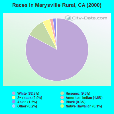
- 5,13082.8%White alone
- 5939.6%Hispanic
- 2443.9%Two or more races
- 971.6%American Indian alone
- 961.5%Asian alone
- 160.3%Black alone
- 100.2%Other race alone
- 90.1%Native Hawaiian and Other
Pacific Islander alone
 Recent articles from our blog. Our writers, many of them Ph.D. graduates or candidates, create easy-to-read articles on a wide variety of topics.
Current Local Time: PST time zone
Land area: 180.8 square miles.
Population density: 41 people per square mile (very low).

| Marysville Rural CCD: | 0.9% ($1,379) |
| California: | 0.8% ($1,564) |
Nearest city with pop. 50,000+: Loomis Basin-Folsom Lake, CA  (35.1 miles , pop. 67,397).
Nearest city with pop. 200,000+: Sacramento, CA (49.0 miles , pop. 407,018).
Nearest city with pop. 1,000,000+: Los Angeles, CA (396.4 miles , pop. 3,694,820).
Nearest cities:
), ), ), ), Latitude: 39.26 N, Longitude: 121.44 W
Area code commonly used in this area: 530

| Here: | 7.1% |
| California: | 5.1% |
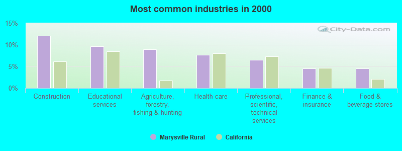
- Construction (12.1%)
- Educational services (9.7%)
- Agriculture, forestry, fishing & hunting (9.0%)
- Health care (7.7%)
- Professional, scientific, technical services (6.5%)
- Finance & insurance (4.5%)
- Food & beverage stores (4.5%)
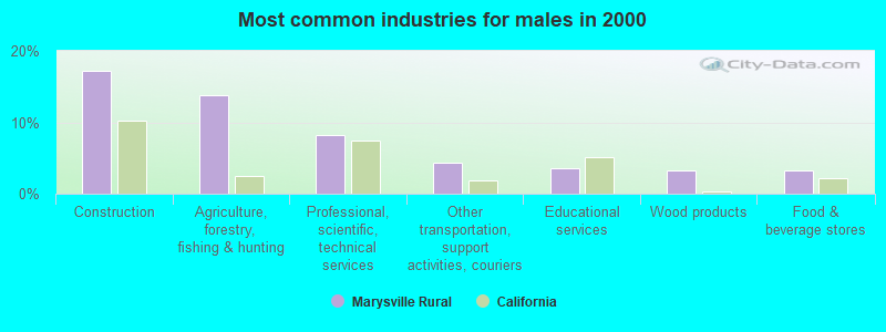
- Construction (17.3%)
- Agriculture, forestry, fishing & hunting (13.8%)
- Professional, scientific, technical services (8.2%)
- Other transportation, support activities, couriers (4.4%)
- Educational services (3.5%)
- Wood products (3.3%)
- Food & beverage stores (3.2%)
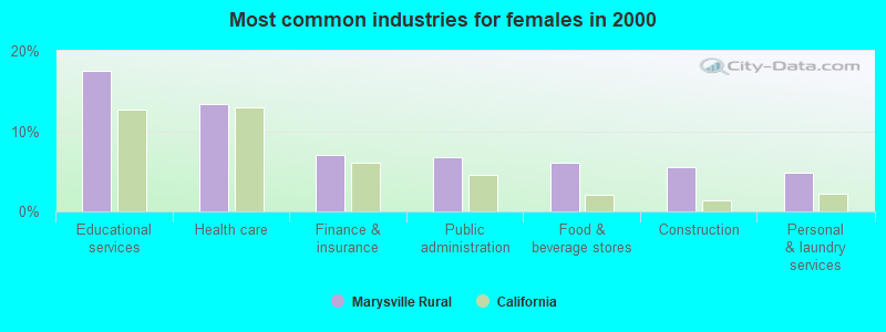
- Educational services (17.5%)
- Health care (13.3%)
- Finance & insurance (7.0%)
- Public administration (6.7%)
- Food & beverage stores (6.1%)
- Construction (5.5%)
- Personal & laundry services (4.8%)
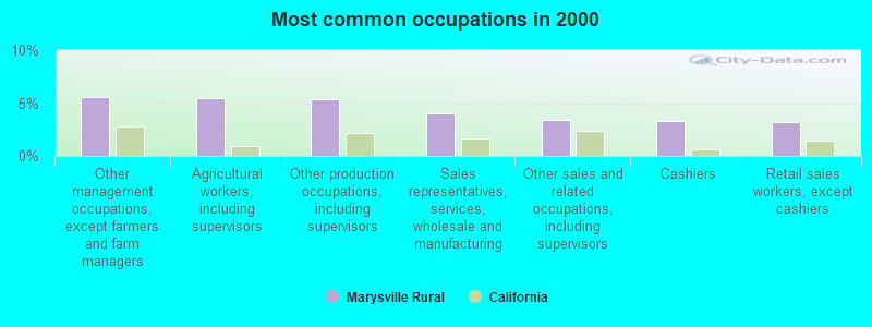
- Other management occupations, except farmers and farm managers (5.6%)
- Agricultural workers, including supervisors (5.5%)
- Other production occupations, including supervisors (5.4%)
- Sales representatives, services, wholesale and manufacturing (4.0%)
- Other sales and related occupations, including supervisors (3.4%)
- Cashiers (3.3%)
- Retail sales workers, except cashiers (3.2%)
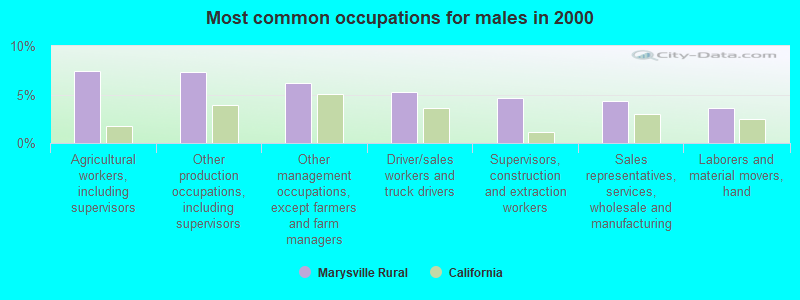
- Agricultural workers, including supervisors (7.4%)
- Other production occupations, including supervisors (7.3%)
- Other management occupations, except farmers and farm managers (6.2%)
- Driver/sales workers and truck drivers (5.3%)
- Supervisors, construction and extraction workers (4.7%)
- Sales representatives, services, wholesale and manufacturing (4.3%)
- Laborers and material movers, hand (3.6%)
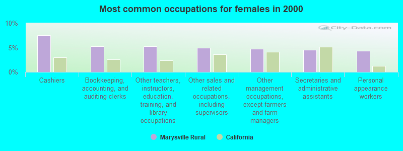
- Cashiers (7.5%)
- Bookkeeping, accounting, and auditing clerks (5.3%)
- Other teachers, instructors, education, training, and library occupations (5.3%)
- Other sales and related occupations, including supervisors (4.9%)
- Other management occupations, except farmers and farm managers (4.8%)
- Secretaries and administrative assistants (4.5%)
- Personal appearance workers (4.3%)
Average climate in Marysville Rural, California
Based on data reported by over 4,000 weather stations


(lower is better)
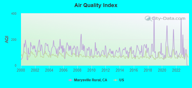
Air Quality Index (AQI) level in 2022 was 120. This is significantly worse than average.
| City: | 120 |
| U.S.: | 73 |
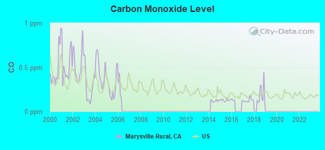
Carbon Monoxide (CO) [ppm] level in 2018 was 0.191. This is better than average. Closest monitor was 12.8 miles away from the city center.
| City: | 0.191 |
| U.S.: | 0.251 |
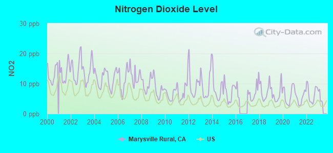
Nitrogen Dioxide (NO2) [ppb] level in 2022 was 6.65. This is worse than average. Closest monitor was 12.8 miles away from the city center.
| City: | 6.65 |
| U.S.: | 5.11 |
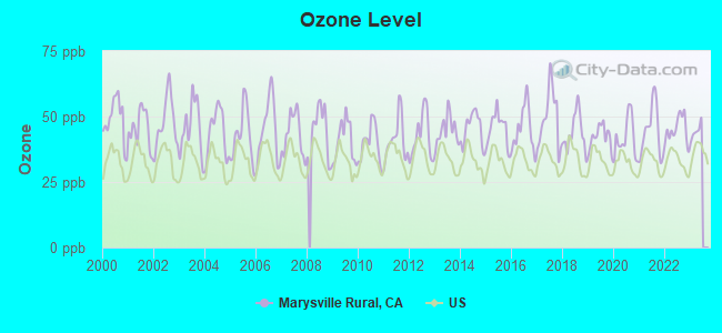
Ozone [ppb] level in 2022 was 45.1. This is worse than average. Closest monitor was 13.1 miles away from the city center.
| City: | 45.1 |
| U.S.: | 33.3 |
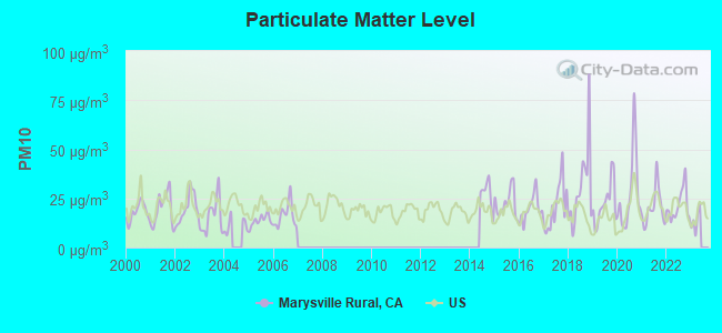
Particulate Matter (PM10) [µg/m3] level in 2022 was 21.5. This is about average. Closest monitor was 10.3 miles away from the city center.
| City: | 21.5 |
| U.S.: | 19.2 |
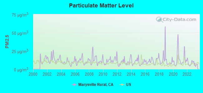
Particulate Matter (PM2.5) [µg/m3] level in 2022 was 8.63. This is about average. Closest monitor was 12.8 miles away from the city center.
| City: | 8.63 |
| U.S.: | 8.11 |
Earthquake activity:
Marysville Rural-area historical earthquake activity is significantly above California state average. It is 7130% greater than the overall U.S. average.On 4/18/1906 at 13:12:21, a magnitude 7.9 (7.9 UK, Class: Major, Intensity: VIII - XII) earthquake occurred 121.4 miles away from Marysville Rural center, causing $524,000,000 total damage
On 10/3/1915 at 06:52:48, a magnitude 7.6 (7.6 UK) earthquake occurred 226.0 miles away from the city center
On 1/31/1922 at 13:17:28, a magnitude 7.6 (7.6 UK) earthquake occurred 239.4 miles away from Marysville Rural center
On 4/25/1992 at 18:06:04, a magnitude 7.2 (6.3 MB, 7.1 MS, 7.2 MW, 7.1 MW, Depth: 9.4 mi) earthquake occurred 158.4 miles away from Marysville Rural center, causing $75,000,000 total damage
On 10/18/1989 at 00:04:15, a magnitude 7.1 (6.5 MB, 7.1 MS, 6.9 MW, 7.0 ML) earthquake occurred 150.1 miles away from the city center, causing 62 deaths (62 shaking deaths) and 3757 injuries, causing $1,305,032,704 total damage
On 12/21/1932 at 06:10:09, a magnitude 7.2 (7.2 UK) earthquake occurred 188.2 miles away from the city center
Magnitude types: body-wave magnitude (MB), local magnitude (ML), surface-wave magnitude (MS), moment magnitude (MW)
Natural disasters:
The number of natural disasters in Yuba County (22) is greater than the US average (15).Major Disasters (Presidential) Declared: 12
Emergencies Declared: 3
Causes of natural disasters: Floods: 12, Fires: 6, Storms: 6, Winter Storms: 5, Landslides: 3, Mudslides: 3, Drought: 1, Freeze: 1, Heavy Rain: 1, Hurricane: 1, Tornado: 1, Other: 1 (Note: some incidents may be assigned to more than one category).
Hospitals and medical centers near Marysville Rural:
- GRANNY'S HOUSE - MAGNOLIA ROAD (Hospital, about 9 miles away; MARYSVILLE, CA)
- MARYSVILLE CARE CENTER (Nursing Home, about 11 miles away; MARYSVILLE, CA)
- RIVER VALLEY CARE CENTER (Nursing Home, about 12 miles away; LIVE OAK, CA)
- MARYSVILLE DIALYSIS CENTER (Dialysis Facility, about 12 miles away; MARYSVILLE, CA)
- RIDEOUT MEMORIAL HOSPITAL Acute Care Hospitals (about 12 miles away; MARYSVILLE, CA)
- YUBA SKILLED NURSING CENTER (Nursing Home, about 13 miles away; YUBA CITY, CA)
- YUBA CITY DIALYSIS CENTER (Dialysis Facility, about 13 miles away; YUBA CITY, CA)
Colleges/universities with over 2000 students nearest to Marysville Rural:
- Yuba College (about 11 miles; Marysville, CA; Full-time enrollment: 4,737)
- Butte College (about 29 miles; Oroville, CA; FT enrollment: 8,649)
- Sierra College (about 35 miles; Rocklin, CA; FT enrollment: 11,488)
- California State University-Chico (about 39 miles; Chico, CA; FT enrollment: 14,838)
- American River College (about 43 miles; Sacramento, CA; FT enrollment: 20,452)
- Universal Technical Institute of Northern California Inc (about 44 miles; Sacramento, CA; FT enrollment: 3,193)
- University of Phoenix-Sacramento Valley Campus (about 45 miles; Sacramento, CA; FT enrollment: 2,855)
Points of interest:
Notable locations in Marysville Rural: Carmichael Ranch (A), Sunset Pumping Station (B), Stone House (C), Sixmile Station (D), Sid Smith Ranch (E), Sevenmile House (F), Pal O Mine Ranch (G), Pacific Ranch (H), District Ten Store (I), La Finca Orchards (J), Fruitland Union School (K), Forbes Ranch (L), Richards Ranch (M), Section Seven Gun Club (N), Loma Rica - Browns Valley Community Service District Fire Station (O), North Tree Fire International Station 20 Main Operations (P). Display/hide their locations on the map
Church in Marysville Rural: Hallwood Church (A). Display/hide its location on the map
Cemeteries: Browns Valley Cemetery (1), Peoria Cemetery (2), Marysville Cemetery (3). Display/hide their locations on the map
Reservoirs: Virginia Ranch Reservoir (A), Merle Collins Reservoir (B), Marysville Lake (C). Display/hide their locations on the map
Streams, rivers, and creeks: Early Creek (A), Injun Creek (B), McGinn Creek (C), Negro Bar Creek (D), Tennessee Creek (E), Dry Creek (F), Simmerly Slough (G), Woods Creek (H), Prairie Creek (I). Display/hide their locations on the map
Park in Marysville Rural: Collins Lake Recreation Area (1). Display/hide its location on the map
| This place: | 2.7 people |
| California: | 2.9 people |
| This place: | 63.2% |
| Whole state: | 69.4% |
| This place: | 4.5% |
| Whole state: | 5.9% |
Likely homosexual households (counted as self-reported same-sex unmarried-partner households)
- Lesbian couples: 0.3% of all households
- Gay men: 0.3% of all households
| This place: | 8.5% |
| Whole state: | 14.2% |
| This place: | 3.1% |
| Whole state: | 6.3% |
6 people in agriculture workers' dormitories on farms in 2000
For population 15 years and over in Marysville Rural:
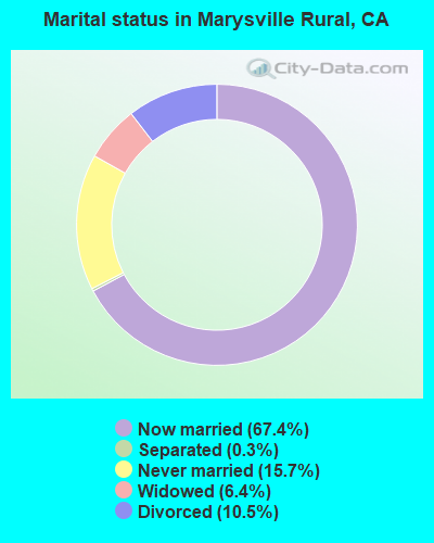
- Never married: 15.7%
- Now married: 67.4%
- Separated: 0.3%
- Widowed: 6.4%
- Divorced: 10.5%
For population 25 years and over in Marysville Rural:
- High school or higher: 82.6%
- Bachelor's degree or higher: 16.0%
- Graduate or professional degree: 5.4%
- Unemployed: 5.8%
- Mean travel time to work (commute): 32.4 minutes
| Here: | 11.7 |
| California average: | 16.1 |
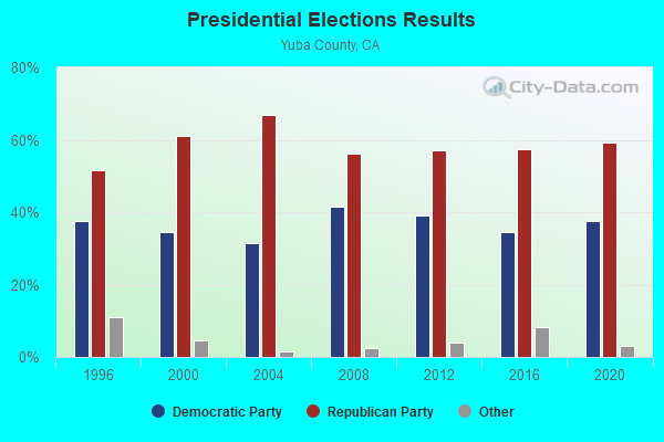
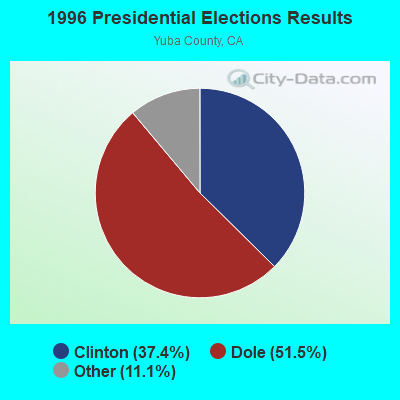
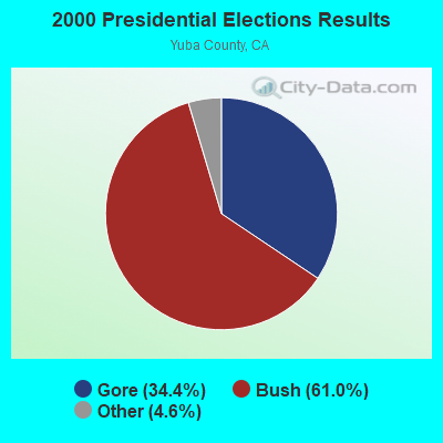
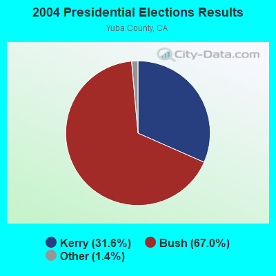
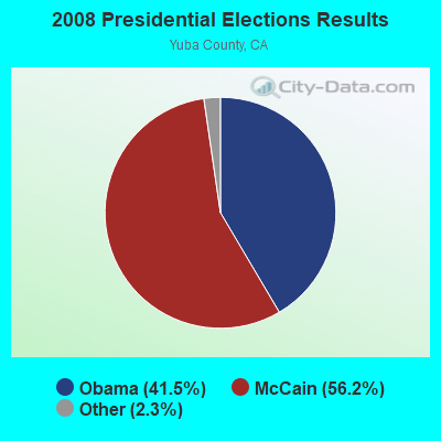
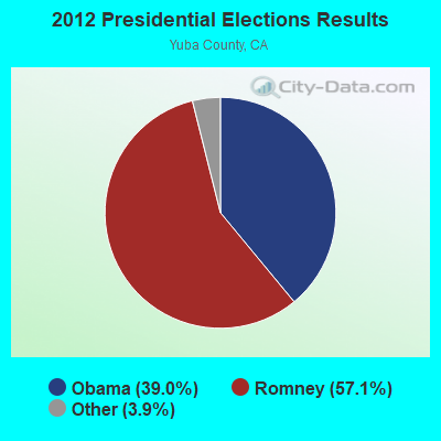
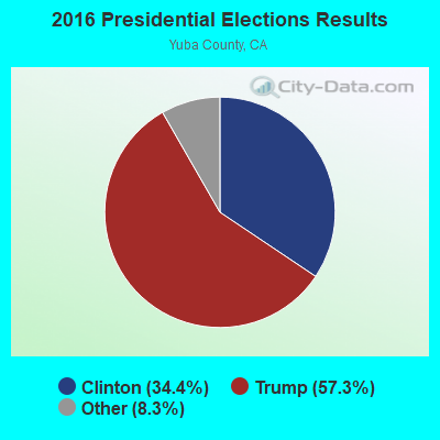
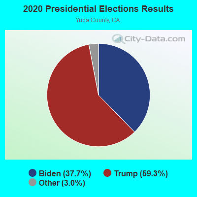
Graphs represent county-level data. Detailed 2008 Election Results
Religion statistics for Marysville Rural, CA (based on Yuba County data)
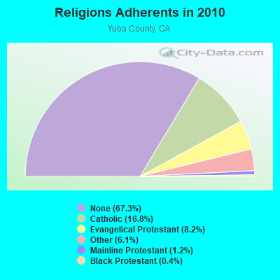
| Religion | Adherents | Congregations |
|---|---|---|
| Catholic | 12,138 | 3 |
| Evangelical Protestant | 5,904 | 46 |
| Other | 4,406 | 9 |
| Mainline Protestant | 891 | 7 |
| Black Protestant | 266 | 1 |
| None | 48,550 | - |
Food Environment Statistics:
| This county: | 1.81 / 10,000 pop. |
| California: | 2.14 / 10,000 pop. |
| Yuba County: | 0.14 / 10,000 pop. |
| California: | 0.04 / 10,000 pop. |
| Yuba County: | 0.84 / 10,000 pop. |
| State: | 0.62 / 10,000 pop. |
| This county: | 2.09 / 10,000 pop. |
| California: | 1.49 / 10,000 pop. |
| Yuba County: | 4.04 / 10,000 pop. |
| California: | 7.42 / 10,000 pop. |
| This county: | 7.2% |
| California: | 7.3% |
| This county: | 27.4% |
| State: | 21.3% |
| Yuba County: | 16.4% |
| California: | 17.9% |
12.15% of this county's 2021 resident taxpayers lived in other counties in 2020 ($52,892 average adjusted gross income)
| Here: | 12.15% |
| California average: | 5.19% |
0.27% of residents moved from foreign countries ($1,145 average AGI)
Yuba County: 0.27% California average: 0.03%
Top counties from which taxpayers relocated into this county between 2020 and 2021:
| from Sacramento County, CA | |
| from Sutter County, CA | |
| from Placer County, CA |
10.93% of this county's 2020 resident taxpayers moved to other counties in 2021 ($50,912 average adjusted gross income)
| Here: | 10.93% |
| California average: | 6.14% |
0.15% of residents moved to foreign countries ($622 average AGI)
Yuba County: 0.15% California average: 0.02%
Top counties to which taxpayers relocated from this county between 2020 and 2021:
| to Sutter County, CA | |
| to Sacramento County, CA | |
| to Placer County, CA |
Strongest AM radio stations in Marysville Rural:
- KFBK (1530 AM; 50 kW; SACRAMENTO, CA; Owner: AMFM RADIO LICENSES, L.L.C.)
- KFIA (710 AM; 25 kW; CARMICHAEL, CA; Owner: VISTA BROADCASTING INC.)
- KMYC (1410 AM; 5 kW; MARYSVILLE, CA; Owner: THOMAS F. HUTH)
- KUBA (1600 AM; 5 kW; YUBA CITY, CA; Owner: HARLAN COMMUNICATIONS, INC.)
- KSTE (650 AM; 25 kW; RANCHO CORDOVA, CA; Owner: AMFM RADIO LICENSES, L.L.C.)
- KHTK (1140 AM; 50 kW; SACRAMENTO, CA; Owner: INFINITY RADIO SUBSIDIARY OPERATIONS INC.)
- KNCO (830 AM; 5 kW; GRASS VALLEY, CA; Owner: NEVADA COUNTY BROADCASTERS, INC.)
- KAHI (950 AM; 10 kW; AUBURN, CA; Owner: IHR EDUCATIONAL BROADCASTING)
- KKOH (780 AM; 50 kW; RENO, NV; Owner: CITADEL BROADCASTING COMPANY)
- KCBS (740 AM; 50 kW; SAN FRANCISCO, CA; Owner: INFINITY BROADCASTING OPERATIONS, INC.)
- KLIB (1110 AM; 10 kW; ROSEVILLE, CA; Owner: WAY BROADCASTING, INC.)
- KCBC (770 AM; 50 kW; RIVERBANK, CA; Owner: KIERTRON, INC.)
- KTRB (860 AM; 50 kW; MODESTO, CA; Owner: PAPPAS RADIO OF CALIFORNIA, A CALIFORNIA LIMITED PARTNERSHIP)
Strongest FM radio stations in Marysville Rural:
- KRCX-FM (99.9 FM; MARYSVILLE, CA; Owner: ENTRAVISION HOLDINGS, LLC)
- KMJE (101.5 FM; GRIDLEY, CA; Owner: RESULTS RADIO LICENSEE, LLC)
- KXCL (103.9 FM; YUBA CITY, CA; Owner: HARLAN COMMUNICATIONS, INC.)
- K213BZ (90.5 FM; RICHVALE, CA; Owner: FAMILY STATIONS, INC.)
- K258AQ (99.5 FM; YANKEE HILL, CA; Owner: CALVARY CHAPEL OF TWIN FALLS, INC.)
- KYIX (104.9 FM; SOUTH OROVILLE, CA; Owner: BUTTE BROADCASTING COMPANY, INC.)
- KHHZ (97.7 FM; OROVILLE, CA; Owner: CLEAR CHANNEL BROADCASTING LICENSES, INC.)
- KKCY (103.1 FM; COLUSA, CA; Owner: RESULTS RADIO LICENSEE, LLC)
- KHAP (89.1 FM; CHICO, CA; Owner: FAMILY STATIONS, INC.)
- KVMR (89.5 FM; NEVADA CITY, CA; Owner: NEVADA CITY COMMUNITY BROADCAST GRUP)
- KLVS (99.3 FM; GRASS VALLEY, CA; Owner: EDUCATIONAL MEDIA FOUNDATION)
- KNCO-FM (94.1 FM; GRASS VALLEY, CA; Owner: NEVADA COUNTY BROADCASTERS, INC.)
- KHGQ (100.3 FM; QUINCY, CA; Owner: KEILY MILLER)
- K205EJ (88.9 FM; CHESTER, CA; Owner: CALVARY CHAPEL OF TWIN FALLS, INC.)
- KNDL (89.9 FM; ANGWIN, CA; Owner: HOWELL MOUNTAIN BROADCASTING COMPANY)
- KLVR (91.9 FM; SANTA ROSA, CA; Owner: EDUCATIONAL MEDIA FOUNDATION)
- KXTS (100.9 FM; CALISTOGA, CA; Owner: SINCLAIR TELECABLE, INC.)
- KHJQ (92.3 FM; SUSANVILLE, CA; Owner: SIERRA BROADCASTING CORPORATION)
- KLVC (88.3 FM; MAGALIA, CA; Owner: EDUCATIONAL MEDIA FOUNDATION)
- K216CF (91.1 FM; CHICO, CA; Owner: YOUR CHRISTIAN COMPANION NETWORK, INC.)
TV broadcast stations around Marysville Rural:
- KMMK-LP (Channel 14; SACRAMENTO, CA; Owner: CABALLERO TELEVISION TEXAS, L.L.C.)
- KEZT-CA (Channel 23; SACRAMENTO, CA; Owner: TELEFUTURA SACRAMENTO LLC)
- K15CX (Channel 15; OROVILLE, CA; Owner: CALIFORNIA BROADCASTING, INC.)
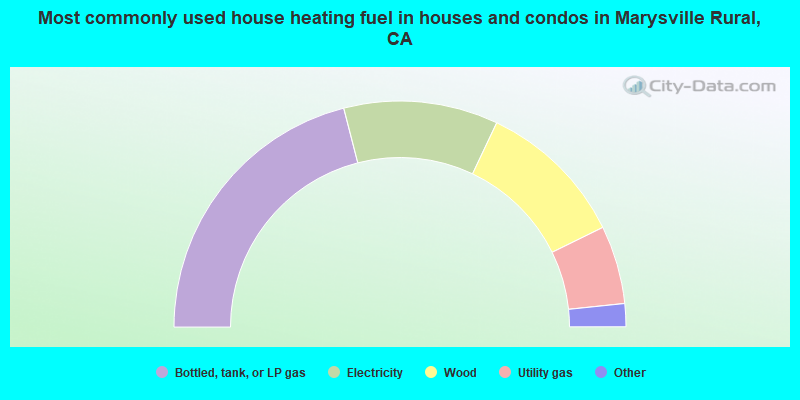
- 42.0%Bottled, tank, or LP gas
- 22.1%Electricity
- 21.4%Wood
- 11.2%Utility gas
- 1.7%Fuel oil, kerosene, etc.
- 1.5%Other fuel
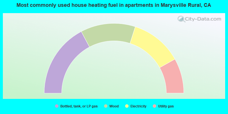
- 34.5%Bottled, tank, or LP gas
- 25.4%Wood
- 23.9%Electricity
- 16.2%Utility gas
Marysville Rural compared to California state average:
- Unemployed percentage below state average.
- Black race population percentage significantly below state average.
- Hispanic race population percentage significantly below state average.
- Median age significantly above state average.
- Foreign-born population percentage significantly below state average.
- Renting percentage significantly below state average.
- Length of stay since moving in significantly above state average.
- Number of rooms per house significantly below state average.
- House age significantly below state average.
- Percentage of population with a bachelor's degree or higher below state average.
Marysville Rural on our top lists:
- #1 on the list of "Top 101 cities with largest percentage of females in occupations: other construction workers and helpers (population 5,000+)"
- #5 on the list of "Top 101 cities with largest percentage of females in occupations: personal appearance workers (population 5,000+)"
- #9 on the list of "Top 101 cities with largest percentage of females in industries: sporting goods, camera, and hobby and toy stores (population 5,000+)"
- #19 on the list of "Top 101 cities with largest percentage of males in industries: social assistance (population 5,000+)"
- #20 on the list of "Top 101 cities with largest percentage of females in industries: lumber and other construction materials merchant wholesalers (population 5,000+)"
- #20 on the list of "Top 101 cities with largest percentage of males in occupations: supervisors of construction and extraction workers (population 5,000+)"
- #22 on the list of "Top 101 cities with largest percentage of females in industries: nonmetallic mineral products (population 5,000+)"
- #22 on the list of "Top 101 cities with largest percentage of males in occupations: drafters, engineering, and mapping technicians (population 5,000+)"
- #22 on the list of "Top 101 cities with largest percentage of females in industries: personal and laundry services (population 5,000+)"
- #32 on the list of "Top 101 cities with largest percentage of females in occupations: other teachers and instructors, education, training, and library occupations (population 5,000+)"
- #33 on the list of "Top 101 cities with largest percentage of males in occupations: agricultural workers including supervisors (population 5,000+)"
- #51 on the list of "Top 101 cities with largest percentage of males in industries: other transportation, and support activities, and couriers (population 5,000+)"
- #53 on the list of "Top 101 cities with largest percentage of females in industries: food and beverage stores (population 5,000+)"
- #56 on the list of "Top 101 cities with largest percentage of males in industries: alcoholic beverages merchant wholesalers (population 5,000+)"
- #59 on the list of "Top 101 cities with largest percentage of females in industries: other direct selling establishments (population 5,000+)"
- #64 on the list of "Top 101 cities with largest percentage of males in industries: building material and garden equipment and supplies dealers (population 5,000+)"
- #67 on the list of "Top 101 cities with largest percentage of males in industries: wood products (population 5,000+)"
- #68 on the list of "Top 101 cities with largest percentage of males in industries: used merchandise, gift, novelty, and souvenir, and other miscellaneous stores (population 5,000+)"
- #70 on the list of "Top 101 cities with largest percentage of males in industries: motor vehicles, parts and supplies merchant wholesalers (population 5,000+)"
- #70 on the list of "Top 101 cities with largest percentage of females in industries: construction (population 5,000+)"
- #30 on the list of "Top 101 counties with the highest percentage of residents relocating to other counties in 2011 (pop. 50,000+)"
- #33 on the list of "Top 101 counties with the highest percentage of residents relocating from foreign countries between 2010 and 2011 (pop. 50,000+)"
- #34 on the list of "Top 101 counties with the highest percentage of residents relocating to foreign countries in 2011 (pop. 50,000+)"
- #35 on the list of "Top 101 counties with highest percentage of residents voting for 3rd party candidates in the 2012 Presidential Election (pop. 50,000+)"
- #40 on the list of "Top 101 counties with the lowest surface withdrawal of fresh water for public supply (pop. 50,000+)"