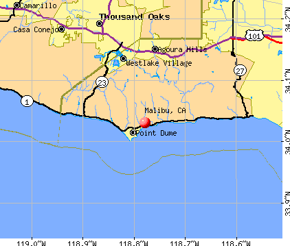
Malibu, California
Malibu: malibu beach
Malibu: Malibu
Malibu: Malibu Pier 5 08 Beautiful Day
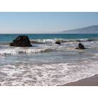
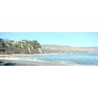
Malibu: Looking North along the Beach
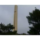
Malibu: Pepperdine University belltower
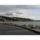
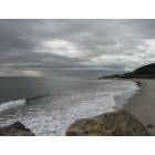
Malibu: Looking South along the Beach towards Los Angeles
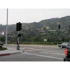
Malibu: Looking across PCH towards the Malibu Mountains
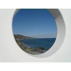
Malibu: Peeking at Paradise
Malibu: Little Dume
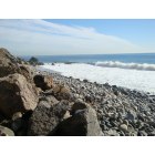
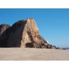
Malibu: Coast Rocks
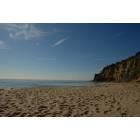
Malibu: Beach
- see
24
more - add
your
Submit your own pictures of this city and show them to the world
- OSM Map
- General Map
- Google Map
- MSN Map
Population change since 2000: -17.5%
 |
| Males: 5,193 | |
| Females: 5,177 |
| Median resident age: | 51.3 years |
| California median age: | 37.9 years |
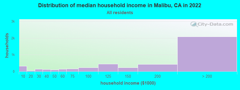
| Malibu: | $184,900 |
| CA: | $91,551 |
Estimated per capita income in 2022: $124,617 (it was $74,336 in 2000)
Malibu city income, earnings, and wages data
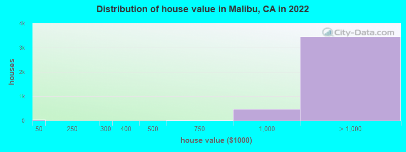
Estimated median house or condo value in 2022: over $1,000,000 (it was $879,200 in 2000)
| Malibu: | over $1,000,000 |
| CA: | $715,900 |
Mean prices in 2022: all housing units: over $1,000,000; detached houses: over $1,000,000; townhouses or other attached units: over $1,000,000; in 2-unit structures: over $1,000,000; in 3-to-4-unit structures: over $1,000,000; in 5-or-more-unit structures: over $1,000,000; mobile homes: over $1,000,000
Median gross rent in 2022: $3,109.
(6.1% for White Non-Hispanic residents, 55.4% for Black residents, 17.1% for Hispanic or Latino residents, 3.0% for other race residents, 24.0% for two or more races residents)
Detailed information about poverty and poor residents in Malibu, CA


Compare current foreclosures near Malibu, CA:
| Photo | Address | Area | Beds / Baths | Price | Details |
|---|---|---|---|---|---|

|
#1
Malibu Vista Dr
Malibu, CA 90265
|
2,564 sq. feet
|
3 baths 4 beds |
show details | |

|
#2
Rambla Pacifico
Malibu, CA 90265
|
8,272 sq. feet
|
11 baths 7 beds |
show details | |

|
#3
Latigo Bay View Dr
Malibu, CA 90265
|
3,870 sq. feet
|
3 baths 4 beds |
show details | |

|
#4
Decker Edison Rd
Malibu, CA 90265
|
3,750 sq. feet
|
4 baths 2 beds |
show details | |

|
#5
Sea Vista Dr
Malibu, CA 90265
|
5,225 sq. feet
|
6 baths 5 beds |
show details | |

|
#6
Decker Edison Rd
Malibu, CA 90265
|
3,750 sq. feet
|
4 baths 2 beds |
show details | |

|
#7
Victoria Point Rd
Malibu, CA 90265
|
3,362 sq. feet
|
3 baths 3 beds |
show details | |

|
#8
Sea Vista Dr
Malibu, CA 90265
|
5,225 sq. feet
|
6 baths 5 beds |
show details | |

|
#9
Selfridge Dr
Malibu, CA 90265
|
- sq. feet
|
3 baths 3 beds |
show details | |

|
#10
Ebbtide Ln
Malibu, CA 90265
|
1,075 sq. feet
|
2 baths 2 beds |
show details |
| Photo | Address | Area | Beds / Baths | Price | Details |
|---|---|---|---|---|---|

|
#11
Victoria Point Rd
Malibu, CA 90265
|
3,362 sq. feet
|
3 baths 3 beds |
show details | |

|
#12
Mulholland Hwy
Malibu, CA 90265
|
- sq. feet
|
- baths - beds |
show details | |

|
#13
Pacific Coast Hwy Ste 2b
Malibu, CA 90265
|
- sq. feet
|
- baths - beds |
show details | |

|
#14
Pacific Coast Hwy
Malibu, CA 90265
|
- sq. feet
|
- baths - beds |
show details | |

|
#15
W Moon Shadows Dr
Malibu, CA 90265
|
- sq. feet
|
- baths - beds |
show details | |

|
#16
Morning View Dr
Malibu, CA 90265
|
- sq. feet
|
- baths - beds |
show details | |

|
#17
Pacific Coast Hwy # 775
Malibu, CA 90265
|
- sq. feet
|
- baths - beds |
show details | |

|
#18
Lockwood Rd
Malibu, CA 90265
|
- sq. feet
|
- baths - beds |
show details | |

|
#19
Rambla Pacifico St
Malibu, CA 90265
|
- sq. feet
|
- baths - beds |
show details | |

|
#20
Piuma Rd
Malibu, CA 90265
|
- sq. feet
|
- baths - beds |
show details |
| Photo | Address | Area | Beds / Baths | Price | Details |
|---|---|---|---|---|---|

|
#21
Owensmouth Ave Unit 107
Woodland Hills, CA 91367
|
1,624 sq. feet
|
3 baths 3 beds |
show details | |

|
#22
Owensmouth Ave Apt 307
Woodland Hills, CA 91367
|
610 sq. feet
|
1 baths 1 beds |
show details | |

|
#23
Burbank Blvd Apt 44
Woodland Hills, CA 91367
|
1,469 sq. feet
|
3 baths 3 beds |
show details | |

|
#24
Wildomar
Pacific Palisades, CA 90272
|
6,193 sq. feet
|
7 baths 6 beds |
show details | |

|
#25
Loire Valley Dr
Simi Valley, CA 93065
|
5,100 sq. feet
|
5 baths 4 beds |
show details | |

|
#26
Calle Riscoso
Thousand Oaks, CA 91362
|
2,501 sq. feet
|
3 baths 4 beds |
show details | |

|
#27
Abargo St
Woodland Hills, CA 91364
|
3,120 sq. feet
|
5 baths 5 beds |
show details | |

|
#28
W Sunset Blvd Unit 302
Pacific Palisades, CA 90272
|
1,244 sq. feet
|
2 baths 2 beds |
show details | |

|
#29
San Miguel St
Woodland Hills, CA 91364
|
2,450 sq. feet
|
2 baths 3 beds |
show details | |

|
#30
Alhama Dr
Woodland Hills, CA 91364
|
1,626 sq. feet
|
2 baths 3 beds |
show details |
| Photo | Address | Area | Beds / Baths | Price | Details |
|---|---|---|---|---|---|

|
#31
Fallbrook Ave
Woodland Hills, CA 91367
|
2,422 sq. feet
|
3 baths 4 beds |
show details | |

|
#32
Farralone Ave
Woodland Hills, CA 91367
|
6,861 sq. feet
|
7 baths 7 beds |
show details | |

|
#33
Burbank Blvd Unit 230c
Woodland Hills, CA 91367
|
- sq. feet
|
2 baths 2 beds |
show details | |

|
#34
Burbank Blvd Unit 357f
Woodland Hills, CA 91367
|
458 sq. feet
|
1 baths 1 beds |
show details | |

|
#35
Serrania Ave
Woodland Hills, CA 91364
|
2,916 sq. feet
|
3 baths 3 beds |
show details | |

|
#36
Hamlin St
Canoga Park, CA 91303
|
1,500 sq. feet
|
2 baths 3 beds |
show details | |

|
#37
Nita Ave
Woodland Hills, CA 91367
|
1,067 sq. feet
|
2 baths 2 beds |
show details | |

|
#38
De Forest St
Woodland Hills, CA 91364
|
3,494 sq. feet
|
3 baths 5 beds |
show details | |

|
#39
La Paloma Cir
Thousand Oaks, CA 91360
|
956 sq. feet
|
1 baths 2 beds |
show details | |

|
#40
El Medio Ave
Pacific Palisades, CA 90272
|
4,724 sq. feet
|
3 baths 4 beds |
show details |
| Photo | Address | Area | Beds / Baths | Price | Details |
|---|---|---|---|---|---|

|
#41
Sapphire Dragon St
Newbury Park, CA 91320
|
2,805 sq. feet
|
3 baths 4 beds |
show details | |

|
#42
Edgar Ct
Newbury Park, CA 91320
|
1,956 sq. feet
|
3 baths 4 beds |
show details | |

|
#43
W Sunset Blvd Apt 302
Pacific Palisades, CA 90272
|
1,396 sq. feet
|
2 baths 2 beds |
show details | |

|
#44
Earlham St
Pacific Palisades, CA 90272
|
2,481 sq. feet
|
3 baths 2 beds |
show details | |

|
#45
Theresa Dr
Newbury Park, CA 91320
|
1,630 sq. feet
|
2 baths 4 beds |
show details | |

|
#46
Camino Del Cielo
Newbury Park, CA 91320
|
2,615 sq. feet
|
3 baths 5 beds |
show details | |

|
#47
Windom St
Canoga Park, CA 91304
|
2,792 sq. feet
|
3 baths 5 beds |
show details | |

|
#48
Calle Posadas
Newbury Park, CA 91320
|
2,171 sq. feet
|
3 baths 3 beds |
show details | |

|
#49
Oxnard St Apt 34
Woodland Hills, CA 91367
|
2,166 sq. feet
|
3 baths 3 beds |
show details | |

|
Check over 1 million property listings on Foreclosure.com!
|
browse all offers | |||


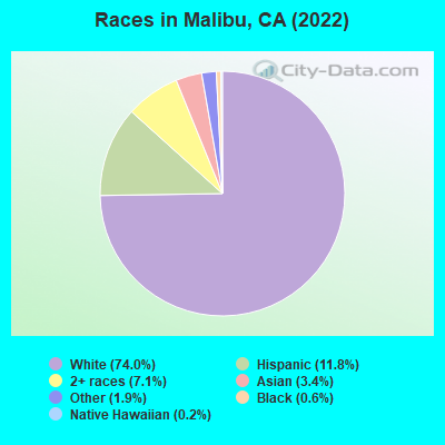
- 7,74474.0%White alone
- 1,23611.8%Hispanic
- 7487.1%Two or more races
- 3583.4%Asian alone
- 1981.9%Other race alone
- 620.6%Black alone
- 230.2%Native Hawaiian and Other
Pacific Islander alone
According to our research of California and other state lists, there were 5 registered sex offenders living in Malibu, California as of July 02, 2024.
The ratio of all residents to sex offenders in Malibu is 2,591 to 1.
The ratio of registered sex offenders to all residents in this city is much lower than the state average.
Type |
2009 |
2010 |
2011 |
2012 |
2013 |
2014 |
2015 |
2016 |
2017 |
2018 |
2019 |
2020 |
2022 |
|---|---|---|---|---|---|---|---|---|---|---|---|---|---|
| Murders (per 100,000) | 0 (0.0) | 1 (7.9) | 0 (0.0) | 0 (0.0) | 0 (0.0) | 0 (0.0) | 0 (0.0) | 0 (0.0) | 0 (0.0) | 1 (7.7) | 1 (7.8) | 0 (0.0) | 0 (0.0) |
| Rapes (per 100,000) | 0 (0.0) | 1 (7.9) | 2 (15.6) | 4 (31.1) | 3 (23.3) | 7 (54.2) | 8 (61.4) | 6 (46.0) | 8 (61.9) | 9 (69.7) | 5 (39.1) | 9 (76.7) | 10 (97.8) |
| Robberies (per 100,000) | 3 (23.0) | 6 (47.4) | 2 (15.6) | 5 (38.9) | 11 (85.3) | 3 (23.2) | 7 (53.7) | 13 (99.8) | 6 (46.4) | 9 (69.7) | 16 (125.1) | 7 (59.6) | 9 (88.0) |
| Assaults (per 100,000) | 22 (168.5) | 18 (142.3) | 11 (86.0) | 6 (46.7) | 14 (108.6) | 15 (116.2) | 10 (76.7) | 19 (145.8) | 24 (185.8) | 18 (139.4) | 22 (172.0) | 24 (204.5) | 40 (391.2) |
| Burglaries (per 100,000) | 61 (467.1) | 73 (577.3) | 76 (594.0) | 78 (606.8) | 81 (628.3) | 81 (627.3) | 84 (644.5) | 87 (667.7) | 78 (603.8) | 74 (573.2) | 86 (672.2) | 67 (570.9) | 78 (762.8) |
| Thefts (per 100,000) | 198 (1,516) | 260 (2,056) | 182 (1,423) | 232 (1,805) | 246 (1,908) | 213 (1,650) | 255 (1,957) | 283 (2,172) | 255 (1,974) | 277 (2,145) | 311 (2,431) | 271 (2,309) | 317 (3,100) |
| Auto thefts (per 100,000) | 20 (153.2) | 17 (134.4) | 10 (78.2) | 19 (147.8) | 23 (178.4) | 18 (139.4) | 21 (161.1) | 32 (245.6) | 33 (255.5) | 29 (224.6) | 19 (148.5) | 17 (144.9) | 25 (244.5) |
| Arson (per 100,000) | 2 (15.3) | 0 (0.0) | 0 (0.0) | 0 (0.0) | 1 (7.8) | 3 (23.2) | 1 (7.7) | 1 (7.7) | 0 (0.0) | 1 (7.7) | 3 (23.4) | 5 (42.6) | 7 (68.5) |
| City-Data.com crime index | 146.2 | 198.3 | 139.1 | 172.4 | 200.5 | 194.6 | 216.8 | 249.2 | 242.3 | 264.0 | 275.0 | 264.1 | 379.8 |
The City-Data.com crime index weighs serious crimes and violent crimes more heavily. Higher means more crime, U.S. average is 246.1. It adjusts for the number of visitors and daily workers commuting into cities.
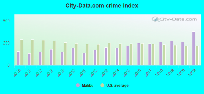
Crime rate in Malibu detailed stats: murders, rapes, robberies, assaults, burglaries, thefts, arson
Full-time law enforcement employees in 2015, including police officers: 1 (1 officers - 1 male; 0 female).
| Officers per 1,000 residents here: | 0.08 |
| California average: | 1.98 |
 Recent articles from our blog. Our writers, many of them Ph.D. graduates or candidates, create easy-to-read articles on a wide variety of topics.


Latest news from Malibu, CA collected exclusively by city-data.com from local newspapers, TV, and radio stations
Ancestries: English (11.2%), German (9.1%), European (7.4%), American (6.9%), Italian (5.7%), Swedish (4.8%).
Current Local Time: PST time zone
Elevation: 112 feet
Land area: 19.9 square miles.
Population density: 522 people per square mile (low).
1,614 residents are foreign born (6.4% Europe, 4.8% Asia, 2.4% Latin America).
| This city: | 15.4% |
| California: | 26.5% |
Median real estate property taxes paid for housing units with mortgages in 2022: $10,281 (0.5%)
Median real estate property taxes paid for housing units with no mortgage in 2022: $10,472 (0.5%)
Nearest city with pop. 50,000+: Thousand Oaks, CA  (12.3 miles , pop. 117,005).
Nearest city with pop. 200,000+: Los Angeles, CA (23.4 miles , pop. 3,694,820).
Nearest cities:
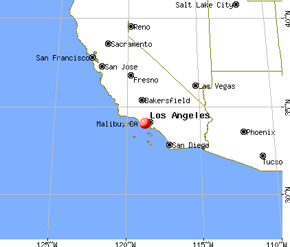
), ), ), ), )Latitude: 34.03 N, Longitude: 118.78 W
Daytime population change due to commuting: +8,190 (+78.3%)
Workers who live and work in this city: 2,621 (56.9%)
Area code: 310
Property values in Malibu, CA

Malibu tourist attractions:
- Broad Beach
- Adamson House and Malibu Lagoon Museum
- El Matador Beach
- El Pescador State Beach
- Corral State Beach
- David Minkin's Evening of Enchantment
- Las Tunas State Beach
- La Piedra Beach
- Leo Carrillo State Park and Beach
- Malibu Pier
- Malibu Lagoon State Beach
- Malibu Colony
- Nicholas Canyon Beach
- Nicholas Flat Trail
- Point Mugu State Park
- Point Dume State Beach and Preserve
- Ramirez Canyon Park
- Paradise Cove
- Topanga State Beach
- Zuma Beach
- Rosenthal Estate Winery Tasting Room
- Solstice Canyon
- Sostomo Trail
- Malibu Beach Inn
Malibu, California accommodation & food services, waste management - Economy and Business Data
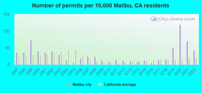
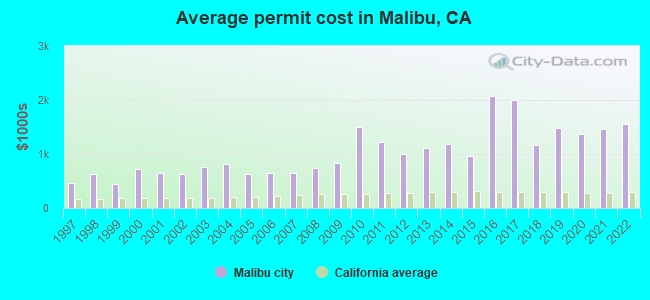
Single-family new house construction building permits:
- 2022: 54 buildings, average cost: $1,553,600
- 2021: 88 buildings, average cost: $1,466,100
- 2020: 150 buildings, average cost: $1,368,800
- 2019: 64 buildings, average cost: $1,490,000
- 2018: 20 buildings, average cost: $1,166,200
- 2017: 18 buildings, average cost: $1,998,000
- 2016: 8 buildings, average cost: $2,066,400
- 2015: 18 buildings, average cost: $953,700
- 2014: 11 buildings, average cost: $1,191,700
- 2013: 12 buildings, average cost: $1,112,700
- 2012: 18 buildings, average cost: $994,500
- 2011: 20 buildings, average cost: $1,230,100
- 2010: 12 buildings, average cost: $1,502,500
- 2009: 19 buildings, average cost: $840,300
- 2008: 30 buildings, average cost: $747,500
- 2007: 31 buildings, average cost: $649,600
- 2006: 24 buildings, average cost: $644,500
- 2005: 7 buildings, average cost: $629,700
- 2004: 16 buildings, average cost: $816,100
- 2003: 39 buildings, average cost: $768,300
- 2002: 52 buildings, average cost: $636,700
- 2001: 47 buildings, average cost: $641,400
- 2000: 51 buildings, average cost: $718,700
- 1999: 92 buildings, average cost: $438,200
- 1998: 47 buildings, average cost: $637,800
- 1997: 45 buildings, average cost: $462,700
| Here: | 5.0% |
| California: | 5.1% |
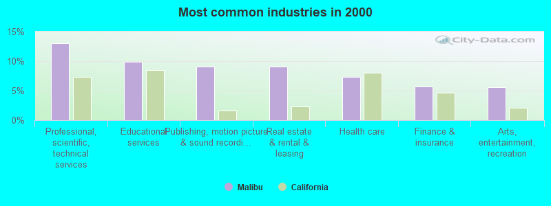
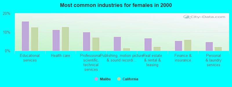
- Professional, scientific, technical services (13.1%)
- Educational services (9.8%)
- Publishing, motion picture & sound recording industries (9.1%)
- Real estate & rental & leasing (9.1%)
- Health care (7.3%)
- Finance & insurance (5.7%)
- Arts, entertainment, recreation (5.6%)
- Professional, scientific, technical services (15.2%)
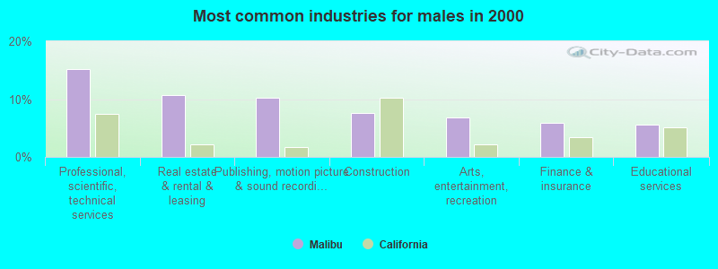
- Real estate & rental & leasing (10.6%)
- Publishing, motion picture & sound recording industries (10.2%)
- Construction (7.6%)
- Arts, entertainment, recreation (6.9%)
- Finance & insurance (5.9%)
- Educational services (5.5%)
- Educational services (15.8%)
- Health care (11.4%)
- Professional, scientific, technical services (10.1%)
- Publishing, motion picture & sound recording industries (7.6%)
- Real estate & rental & leasing (6.9%)
- Finance & insurance (5.5%)
- Personal & laundry services (4.7%)
- Other management occupations, except farmers and farm managers (9.5%)
- Other sales and related occupations, including supervisors (7.6%)
- Lawyers (7.4%)
- Top executives (5.2%)
- Entertainers and performers, sports, and related workers (4.8%)
- Sales representatives, services, wholesale and manufacturing (3.6%)
- Media and communications workers (3.0%)
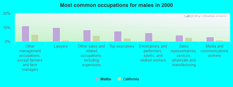
- Other management occupations, except farmers and farm managers (11.1%)
- Lawyers (10.0%)
- Other sales and related occupations, including supervisors (8.2%)
- Top executives (7.4%)
- Entertainers and performers, sports, and related workers (6.1%)
- Sales representatives, services, wholesale and manufacturing (4.4%)
- Media and communications workers (3.4%)
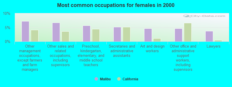
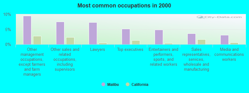
- Other management occupations, except farmers and farm managers (7.2%)
- Other sales and related occupations, including supervisors (6.7%)
- Preschool, kindergarten, elementary, and middle school teachers (5.6%)
- Secretaries and administrative assistants (5.2%)
- Art and design workers (4.6%)
- Other office and administrative support workers, including supervisors (4.6%)
- Lawyers (3.7%)
Average climate in Malibu, California
Based on data reported by over 4,000 weather stations


(lower is better)
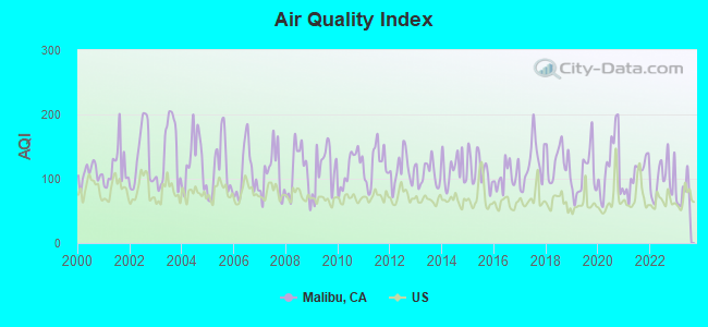
Air Quality Index (AQI) level in 2023 was 76.6. This is about average.
| City: | 76.6 |
| U.S.: | 72.6 |
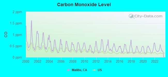
Carbon Monoxide (CO) [ppm] level in 2022 was 0.352. This is worse than average. Closest monitor was 17.9 miles away from the city center.
| City: | 0.352 |
| U.S.: | 0.251 |
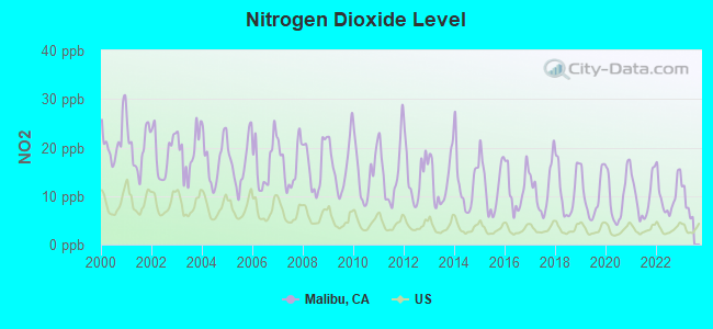
Nitrogen Dioxide (NO2) [ppb] level in 2022 was 10.2. This is significantly worse than average. Closest monitor was 10.4 miles away from the city center.
| City: | 10.2 |
| U.S.: | 5.1 |
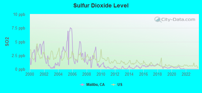
Sulfur Dioxide (SO2) [ppb] level in 2021 was 0.147. This is significantly better than average. Closest monitor was 10.4 miles away from the city center.
| City: | 0.147 |
| U.S.: | 1.515 |
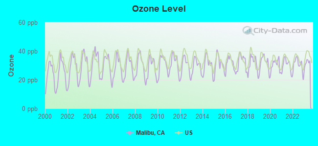
Ozone [ppb] level in 2023 was 31.6. This is about average. Closest monitor was 10.4 miles away from the city center.
| City: | 31.6 |
| U.S.: | 33.3 |
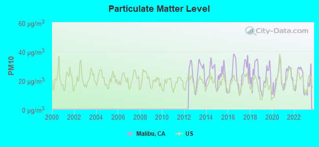
Particulate Matter (PM10) [µg/m3] level in 2023 was 16.7. This is about average. Closest monitor was 13.5 miles away from the city center.
| City: | 16.7 |
| U.S.: | 19.2 |
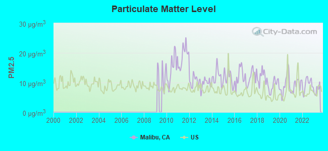
Particulate Matter (PM2.5) [µg/m3] level in 2023 was 7.53. This is about average. Closest monitor was 13.5 miles away from the city center.
| City: | 7.53 |
| U.S.: | 8.11 |
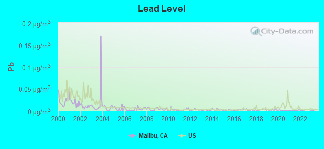
Lead (Pb) [µg/m3] level in 2023 was 0.00179. This is significantly better than average. Closest monitor was 17.9 miles away from the city center.
| City: | 0.00179 |
| U.S.: | 0.00931 |
Earthquake activity:
Malibu-area historical earthquake activity is significantly above California state average. It is 6694% greater than the overall U.S. average.On 7/21/1952 at 11:52:14, a magnitude 7.7 (7.7 UK, Class: Major, Intensity: VIII - XII) earthquake occurred 68.2 miles away from Malibu center, causing $50,000,000 total damage
On 6/28/1992 at 11:57:34, a magnitude 7.6 (6.2 MB, 7.6 MS, 7.3 MW, Depth: 0.7 mi) earthquake occurred 129.1 miles away from the city center, causing 3 deaths (1 shaking deaths, 2 other deaths) and 400 injuries, causing $100,000,000 total damage and $40,000,000 insured losses
On 11/4/1927 at 13:51:53, a magnitude 7.5 (7.5 UK) earthquake occurred 142.3 miles away from Malibu center
On 10/16/1999 at 09:46:44, a magnitude 7.4 (6.3 MB, 7.4 MS, 7.2 MW, 7.3 ML) earthquake occurred 138.1 miles away from the city center
On 1/17/1994 at 12:30:55, a magnitude 6.8 (6.4 MB, 6.8 MS, 6.7 MW, Depth: 11.4 mi, Class: Strong, Intensity: VII - IX) earthquake occurred 14.5 miles away from the city center, causing 60 deaths (60 shaking deaths) and 7000 injuries
On 4/21/1918 at 22:32:30, a magnitude 6.8 (6.8 UK) earthquake occurred 78.3 miles away from Malibu center
Magnitude types: body-wave magnitude (MB), local magnitude (ML), surface-wave magnitude (MS), moment magnitude (MW)
Natural disasters:
The number of natural disasters in Los Angeles County (57) is a lot greater than the US average (15).Major Disasters (Presidential) Declared: 27
Emergencies Declared: 3
Causes of natural disasters: Fires: 37, Floods: 16, Storms: 9, Winter Storms: 6, Landslides: 5, Mudslides: 5, Earthquakes: 3, Freeze: 1, Heavy Rain: 1, Hurricane: 1, Snow: 1, Tornado: 1, Wind: 1, Other: 1 (Note: some incidents may be assigned to more than one category).

Main business address for: LTC PROPERTIES INC (REAL ESTATE INVESTMENT TRUSTS), JAKKS PACIFIC INC (GAMES, TOYS & CHILDREN'S VEHICLES (NO DOLLS & BICYCLES)).
Hospitals and medical centers near Malibu:
- SHC SPECIALTY COMPREHENSIVE CANCER CTR (Hospital, about 9 miles away; WESTLAKE VILLAGE, CA)
- AMERICAN DREAM HOME HEALTH CARE, INC (Home Health Center, about 9 miles away; WESTLAKE VILLAGE, CA)
- INFINITE HOME HEALTH INC (Home Health Center, about 10 miles away; WESTLAKE VILLAGE, CA)
- ROYAL HOME CARE INC (Home Health Center, about 10 miles away; WESTLAKE VILLAGE, CA)
- LOS ROBLES HOSPITAL AND MEDICAL CENTER D/P SNF (Nursing Home, about 10 miles away; THOUSAND OAKS, CA)
- 24-7 QUALITY INFUSION AND HOME HEALTH INC (Home Health Center, about 10 miles away; WESTLAKE VILLAGE, CA)
- BUENA VISTA HOSPICE CARE, INC (Hospital, about 10 miles away; WESTLAKE VILLAGE, CA)
Heliports located in Malibu:
- Anacapa View Estates Heliport (CL10)
- Camp 8 Heliport (CL72)
- Hughes/Malibu Heliport (CA50)
- Malibu Administrative Center Heliport (74L)
Amtrak stations near Malibu:
- 18 miles: SIMI VALLEY (5000 E. LOS ANGELES AVE.) . Services: public payphones, free short-term parking, call for taxi service, public transit connection.
- 19 miles: MOORPARK (300 HIGH ST.) . Services: free short-term parking, public transit connection.
- 19 miles: CHATSWORTH (21510 DEVONSHIRE ST.) . Services: public payphones, free short-term parking, free long-term parking, taxi stand, public transit connection.
College/University in Malibu:
Other colleges/universities with over 2000 students near Malibu:
- California Lutheran University (about 15 miles; Thousand Oaks, CA; Full-time enrollment: 4,103)
- Los Angeles Pierce College (about 16 miles; Woodland Hills, CA; FT enrollment: 10,996)
- Mount St Mary's College (about 18 miles; Los Angeles, CA; FT enrollment: 2,431)
- Santa Monica College (about 18 miles; Santa Monica, CA; FT enrollment: 20,311)
- California State University-Channel Islands (about 18 miles; Camarillo, CA; FT enrollment: 4,163)
- Moorpark College (about 19 miles; Moorpark, CA; FT enrollment: 9,338)
- University of California-Los Angeles (about 20 miles; Los Angeles, CA; FT enrollment: 39,409)
Public high schools in Malibu:
- MALIBU HIGH (Students: 993, Location: 30215 MORNING VIEW DR., Grades: 6-12)
- MILLER, FRED C. CAMP (Location: 433 S. ENCINAL CANYON RD., Grades: 7-12)
- KILPATRICK, VERNON CAMP (Location: 427 S. ENCINAL CANYON RD., Grades: 7-12)
Private high schools in Malibu:
Public elementary/middle schools in Malibu:
- JUAN CABRILLO ELEMENTARY (Students: 189, Location: 30237 MORNING VIEW DR., Grades: KG-5)
- POINT DUME ELEMENTARY (Students: 176, Location: 6955 FERNHILL DR., Grades: KG-5)
- WEBSTER ELEMENTARY (Location: 3602 WINTER CANYON, Grades: KG-5)
Private elementary/middle school in Malibu:
Points of interest:
Notable locations in Malibu: Malibu Trading Station (A), Rindge Ranch (B), Randge Ranch (C), Malibu Riding and Tennis Club (D), Decker Canyon Youth Camp (E), Malibu Branch County of Los Angeles Public Library (F), Malibu Lagoon Museum (G), Serra Retreat (H), Los Angeles County Fire Department Station 71 (I), Los Angeles County Fire Department Station 88 (J), Los Angeles County Fire Department Station 70 (K), Los Angeles County Fire Department Station 99 (L). Display/hide their locations on the map
Shopping Centers: Trancas Market Shopping Center (1), Point Dume Plaza Shopping Center (2). Display/hide their locations on the map
Main business address in Malibu include: LTC PROPERTIES INC (A), JAKKS PACIFIC INC (B). Display/hide their locations on the map
Parks in Malibu include: Robert H Meyer Memorial State Beach (1), Zuma Beach County Park (2), Dan Blocker Beach (3), El Matador State Beach (4), El Pescador State Beach (5), La Piedra State Beach (6), Point Dume State Beach (7), Charmlee County Park (8), Malibu Bluffs Park (9). Display/hide their locations on the map
Beaches: Carbon Beach (A), Encinal Beach (B), Malibu Beach (C), Puerco Beach (D), Amarillo Beach (E), Corral Beach (F), Trancas Beach (G), Big Rock Beach (H). Display/hide their locations on the map
Tourist attractions: Adamson House Reservations (Museums; 23200 Pacific Coast Highway) (1), California State - Parks & Recreation Department- Angeles District- Malibu Lagoon State B (Museums; 23200 Pacific Coast Highway) (2). Display/hide their approximate locations on the map
Hotel: Amber Hotel Company (29169 Heathercliff Road Suite 213) (1). Display/hide its approximate location on the map
Birthplace of: Colette Carr - Singer and rapper, Daniela Sea - Performance artist, Dominique Swain - Film actor, Jim McLaughlin (coach) - Volleyball player, Scott Menville - Actor, Shayne Lamas - Television personality, Timothy Hutton - (born 1960), actor, Chad Rogers - Television personality, Jennifer Landon - Soap opera actor, Kristoffer Tabori - Film actor.
Drinking water stations with addresses in Malibu that have no violations reported:
- OCEAN SONG FARM & WILDERNESS CENTER (Population served: 50, Primary Water Source Type: Groundwater)
- LAZY J RANCH (Population served: 25, Primary Water Source Type: Groundwater)
| This city: | 2.4 people |
| California: | 2.9 people |
| This city: | 60.7% |
| Whole state: | 68.7% |
| This city: | 6.0% |
| Whole state: | 7.2% |
Likely homosexual households (counted as self-reported same-sex unmarried-partner households)
- Lesbian couples: 0.3% of all households
- Gay men: 0.6% of all households
People in group quarters in Malibu in 2010:
- 73 people in other noninstitutional facilities
- 53 people in residential treatment centers for adults
- 9 people in residential treatment centers for juveniles (non-correctional)
- 6 people in correctional residential facilities
People in group quarters in Malibu in 2000:
- 233 people in college dormitories (includes college quarters off campus)
- 30 people in other nonhousehold living situations
- 24 people in other noninstitutional group quarters
- 8 people in homes for the mentally retarded
- 5 people in religious group quarters
Banks with branches in Malibu (2011 data):
- Bank of America, National Association: Malibu Branch at 23717 West Malibu Road, branch established on 1957/05/06; Point Dume Branch at 29171 Heathercliff Road, branch established on 1968/09/06. Info updated 2009/11/18: Bank assets: $1,451,969.3 mil, Deposits: $1,077,176.8 mil, headquarters in Charlotte, NC, positive income, 5782 total offices, Holding Company: Bank Of America Corporation
- Wells Fargo Bank, National Association: Malibu Branch at 23361 Pacific Coast Highway, branch established on 2000/08/15; Malibu Colony Plaza Branch at 23705 West Malibu Road, branch established on 2007/05/30. Info updated 2011/04/05: Bank assets: $1,161,490.0 mil, Deposits: $905,653.0 mil, headquarters in Sioux Falls, SD, positive income, 6395 total offices, Holding Company: Wells Fargo & Company
- JPMorgan Chase Bank, National Association: 29211 Heathcliff Road Branch at 29211 Heathcliff Rd, branch established on 1919/01/01. Info updated 2011/11/10: Bank assets: $1,811,678.0 mil, Deposits: $1,190,738.0 mil, headquarters in Columbus, OH, positive income, International Specialization, 5577 total offices, Holding Company: Jpmorgan Chase & Co.
- First Bank: Malibu Branch at 23755 West Malibu Road, branch established on 1991/01/11. Info updated 2007/12/04: Bank assets: $6,579.8 mil, Deposits: $5,800.6 mil, headquarters in Creve Coeur, MO, negative income in the last year, Commercial Lending Specialization, 148 total offices, Holding Company: First Banks, Inc.
For population 15 years and over in Malibu:
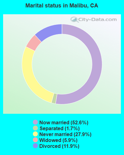
- Never married: 27.9%
- Now married: 52.6%
- Separated: 1.7%
- Widowed: 5.9%
- Divorced: 11.9%
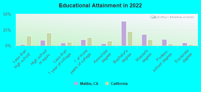
For population 25 years and over in Malibu:
- High school or higher: 97.8%
- Bachelor's degree or higher: 70.3%
- Graduate or professional degree: 31.6%
- Unemployed: 2.8%
- Mean travel time to work (commute): 19.9 minutes
| Here: | 9.3 |
| California average: | 15.5 |
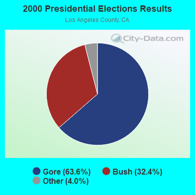
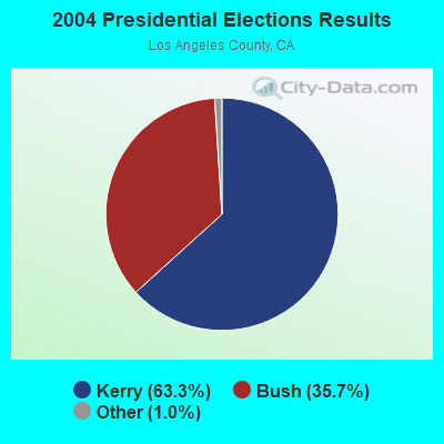
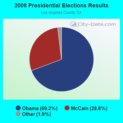

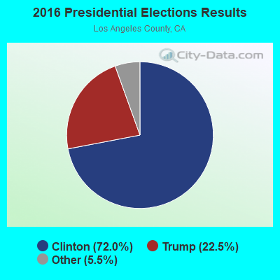
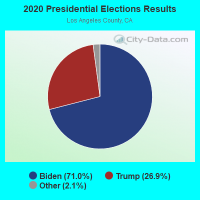
Graphs represent county-level data. Detailed 2008 Election Results
Religion statistics for Malibu, CA (based on Los Angeles County data)
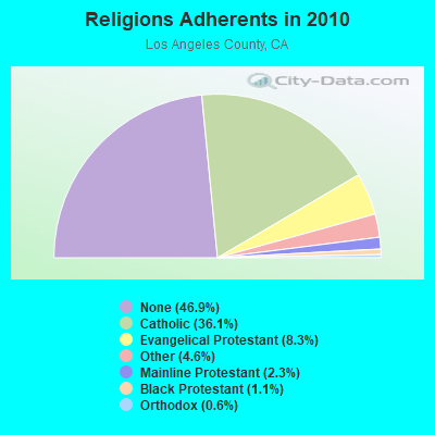
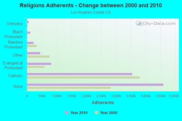
| Religion | Adherents | Congregations |
|---|---|---|
| Catholic | 3,542,994 | 275 |
| Evangelical Protestant | 814,611 | 3,249 |
| Other | 451,594 | 1,023 |
| Mainline Protestant | 229,056 | 860 |
| Black Protestant | 112,338 | 290 |
| Orthodox | 63,517 | 76 |
| None | 4,604,495 | - |
Food Environment Statistics:
| Los Angeles County: | 2.12 / 10,000 pop. |
| State: | 2.14 / 10,000 pop. |
| This county: | 0.03 / 10,000 pop. |
| California: | 0.04 / 10,000 pop. |
| Los Angeles County: | 0.58 / 10,000 pop. |
| California: | 0.62 / 10,000 pop. |
| Here: | 1.23 / 10,000 pop. |
| State: | 1.49 / 10,000 pop. |
| This county: | 7.15 / 10,000 pop. |
| California: | 7.42 / 10,000 pop. |
| This county: | 7.5% |
| State: | 7.3% |
| Los Angeles County: | 20.4% |
| State: | 21.3% |
| Los Angeles County: | 18.6% |
| State: | 17.9% |
Health and Nutrition:
| Malibu: | 55.0% |
| California: | 49.4% |
| Here: | 54.9% |
| California: | 48.0% |
| Malibu: | 28.0 |
| California: | 28.1 |
| Here: | 19.4% |
| State: | 20.2% |
| This city: | 7.6% |
| California: | 11.2% |
| Malibu: | 7.0 |
| California: | 6.8 |
| Malibu: | 34.5% |
| State: | 31.5% |
| Here: | 61.1% |
| State: | 56.4% |
| Malibu: | 80.1% |
| California: | 80.9% |
More about Health and Nutrition of Malibu, CA Residents
| Local government employment and payroll (March 2022) | |||||
| Function | Full-time employees | Monthly full-time payroll | Average yearly full-time wage | Part-time employees | Monthly part-time payroll |
|---|---|---|---|---|---|
| Housing and Community Development (Local) | 24 | $180,978 | $90,489 | 0 | $0 |
| Other and Unallocable | 16 | $121,501 | $91,126 | 1 | $7,067 |
| Parks and Recreation | 10 | $80,640 | $96,768 | 26 | $19,625 |
| Streets and Highways | 9 | $94,495 | $125,993 | 0 | $0 |
| Other Government Administration | 8 | $74,167 | $111,251 | 5 | $2,828 |
| Financial Administration | 7 | $62,550 | $107,229 | 0 | $0 |
| Solid Waste Management | 3 | $22,679 | $90,716 | 0 | $0 |
| Totals for Government | 77 | $637,010 | $99,274 | 32 | $29,520 |
Malibu government finances - Expenditure in 2017 (per resident):
- Construction - Sewerage: $28,274,000 ($2726.52)
- Current Operations - Central Staff Services: $7,915,000 ($763.26)
Police Protection: $7,228,000 ($697.01)
Parks and Recreation: $5,573,000 ($537.42)
Regular Highways: $3,225,000 ($310.99)
Protective Inspection and Regulation - Other: $3,133,000 ($302.12)
Financial Administration: $982,000 ($94.70)
Housing and Community Development: $394,000 ($37.99)
Sewerage: $297,000 ($28.64)
General - Other: $197,000 ($19.00)
Solid Waste Management: $77,000 ($7.43)
Health - Other: $66,000 ($6.36)
- General - Interest on Debt: $1,782,000 ($171.84)
Malibu government finances - Revenue in 2017 (per resident):
- Charges - Housing and Community Development: $1,720,000 ($165.86)
Other: $1,456,000 ($140.41)
Parks and Recreation: $525,000 ($50.63)
Sewerage: $269,000 ($25.94)
Solid Waste Management: $126,000 ($12.15)
- Federal Intergovernmental - Other: $129,000 ($12.44)
Housing and Community Development: $7,000 ($0.68)
- Local Intergovernmental - Other: $262,000 ($25.27)
Housing and Community Development: $190,000 ($18.32)
- Miscellaneous - Special Assessments: $30,694,000 ($2959.88)
Fines and Forfeits: $769,000 ($74.16)
General Revenue - Other: $423,000 ($40.79)
Interest Earnings: $195,000 ($18.80)
- State Intergovernmental - Highways: $245,000 ($23.63)
General Local Government Support: $63,000 ($6.08)
Other: $31,000 ($2.99)
- Tax - Property: $11,848,000 ($1142.53)
General Sales and Gross Receipts: $4,674,000 ($450.72)
Other License: $4,437,000 ($427.87)
Other Selective Sales: $3,714,000 ($358.15)
Public Utilities Sales: $3,084,000 ($297.40)
Documentary and Stock Transfer: $841,000 ($81.10)
Malibu government finances - Debt in 2017 (per resident):
- Long Term Debt - Outstanding Unspecified Public Purpose: $58,252,000 ($5617.36)
Beginning Outstanding - Unspecified Public Purpose: $55,937,000 ($5394.12)
Issue, Unspecified Public Purpose: $9,001,000 ($867.98)
Retired Unspecified Public Purpose: $6,687,000 ($644.84)
Malibu government finances - Cash and Securities in 2017 (per resident):
- Bond Funds - Cash and Securities: $2,088,000 ($201.35)
- Other Funds - Cash and Securities: $46,779,000 ($4510.99)
2.98% of this county's 2021 resident taxpayers lived in other counties in 2020 ($81,235 average adjusted gross income)
| Here: | 2.98% |
| California average: | 5.19% |
0.01% of residents moved from foreign countries ($155 average AGI)
Los Angeles County: 0.01% California average: 0.03%
Top counties from which taxpayers relocated into this county between 2020 and 2021:
| from Orange County, CA | |
| from San Bernardino County, CA | |
| from Riverside County, CA |
4.68% of this county's 2020 resident taxpayers moved to other counties in 2021 ($97,324 average adjusted gross income)
| Here: | 4.68% |
| California average: | 6.14% |
0.01% of residents moved to foreign countries ($196 average AGI)
Los Angeles County: 0.01% California average: 0.02%
Top counties to which taxpayers relocated from this county between 2020 and 2021:
| to Orange County, CA | |
| to San Bernardino County, CA | |
| to Riverside County, CA |
| Businesses in Malibu, CA | ||||
| Name | Count | Name | Count | |
|---|---|---|---|---|
| Banana Republic | 1 | Kroger | 1 | |
| Budget Car Rental | 1 | Levi Strauss & Co. | 1 | |
| CVS | 1 | McDonald's | 1 | |
| Circle K | 1 | Nike | 2 | |
| DHL | 1 | RadioShack | 1 | |
| FedEx | 9 | Starbucks | 4 | |
| J.Crew | 1 | T-Mobile | 1 | |
| Jack In The Box | 1 | U-Haul | 1 | |
| Jamba Juice | 1 | UPS | 4 | |
| Juicy Couture | 1 | Vans | 2 | |
| KFC | 1 | Vons | 1 | |
Strongest AM radio stations in Malibu:
- KACD (850 AM; 25 kW; THOUSAND OAKS, CA; Owner: CITICASTERS LICENSES, L.P.)
- KSPN (710 AM; 50 kW; LOS ANGELES, CA; Owner: KABC-AM RADIO, INC.)
- KNX (1070 AM; 50 kW; LOS ANGELES, CA; Owner: INFINITY BROADCASTING OPERATIONS, INC.)
- KFWB (980 AM; 50 kW; LOS ANGELES, CA; Owner: INFINITY BROADCASTING OPERATIONS, INC.)
- KLAC (570 AM; 50 kW; LOS ANGELES, CA; Owner: AMFM RADIO LICENSES, L.L.C.)
- KFI (640 AM; 50 kW; LOS ANGELES, CA; Owner: CAPSTAR TX LIMITED PARTNERSHIP)
- KBLA (1580 AM; 50 kW; SANTA MONICA, CA)
- KSUR (1260 AM; 25 kW; BEVERLY HILLS, CA)
- KMPC (1540 AM; 50 kW; LOS ANGELES, CA; Owner: ROSE CITY RADIO CORPORATION)
- KTNQ (1020 AM; 50 kW; LOS ANGELES, CA; Owner: KTNQ-AM LICENSE CORP.)
- KDIS (1110 AM; 50 kW; PASADENA, CA; Owner: ABC,INC.)
- KRLA (870 AM; 20 kW; GLENDALE, CA; Owner: NEW INSPIRATION BROADCASTING COMPANY)
- KXTA (1150 AM; 50 kW; LOS ANGELES, CA; Owner: CITICASTERS LICENSES, L.P.)
Strongest FM radio stations in Malibu:
- KKBT (100.3 FM; LOS ANGELES, CA; Owner: RADIO ONE LICENSES, LLC)
- KCSN (88.5 FM; NORTHRIDGE, CA; Owner: CALIFORNIA STATE UNIVERSITY, NORTHRIDGE)
- KRTH-FM (101.1 FM; LOS ANGELES, CA; Owner: INFINITY BROADCASTING OPERATIONS, INC.)
- K220FR (91.9 FM; SIMI VALLEY, CA; Owner: LIFE ON THE WAY COMMUNICATIONS, INC.)
- KZLA-FM (93.9 FM; LOS ANGELES, CA; Owner: EMMIS RADIO LICENSE CORPORATION)
- KPWR (105.9 FM; LOS ANGELES, CA; Owner: EMMIS RADIO LICENSE CORPORATION)
- KLSX (97.1 FM; LOS ANGELES, CA; Owner: INFINITY BROADCASTING OPERATIONS, INC.)
- KUSC (91.5 FM; LOS ANGELES, CA; Owner: UNIVERSITY OF SOUTHERN CALIFORNIA)
- KKLA-FM (99.5 FM; LOS ANGELES, CA; Owner: NEW INSPIRATION BROADCASTING CO., INC.)
- KMLT (92.7 FM; THOUSAND OAKS, CA; Owner: AMATURO GROUP OF L.A., LTD.)
- KCBS-FM (93.1 FM; LOS ANGELES, CA; Owner: INFINITY BROADCASTING OPERATIONS, INC.)
- K272DI (102.3 FM; FILLMORE, CA; Owner: SANTA MONICA COMMUNITY COLLEGE DIST.)
- KSCA (101.9 FM; GLENDALE, CA; Owner: HBC LICENSE CORPORATION)
- K212FA (90.3 FM; TEMPLE CITY, CA; Owner: EDUCATIONAL MEDIA FOUNDATION)
- KLOS (95.5 FM; LOS ANGELES, CA; Owner: KLOS-FM RADIO, INC.)
- KWVS-LP (101.5 FM; MALIBU, CA; Owner: PEPPERDINE UNIVERSITY)
- KOST (103.5 FM; LOS ANGELES, CA; Owner: CAPSTAR TX LIMITED PARTNERSHIP)
- K261AB (100.1 FM; NEWHALL, ETC., CA; Owner: RADIO ONE LICENSES, LLC)
- KCZN (96.7 FM; SANTA PAULA, CA; Owner: LAZER BROADCASTING CORPORATION)
- KBBY-FM (95.1 FM; VENTURA, CA; Owner: CUMULUS LICENSING CORP.)
TV broadcast stations around Malibu:
- KTRO-LP (Channel 50; LANCASTER, CA; Owner: ROBERT D. ADELMAN)
- KCBS-TV (Channel 2; LOS ANGELES, CA; Owner: CBS BROADCASTING INC.)
- KADY-TV (Channel 63; OXNARD, CA; Owner: BILTMORE BROADCASTING, L.L.C.)
- KSMV-LP (Channel 33; LOS ANGELES, CA; Owner: KJLA, LLC)
- National Bridge Inventory (NBI) Statistics
- 17Number of bridges
- 138ft / 41.6mTotal length
- $2,930,000Total costs
- 355,323Total average daily traffic
- 8,355Total average daily truck traffic
- 435,091Total future (year 2027) average daily traffic
- New bridges - historical statistics
- 81920-1929
- 21930-1939
- 21940-1949
- 11960-1969
- 21990-1999
- 22000-2009
FCC Registered Antenna Towers: 52 (See the full list of FCC Registered Antenna Towers)
FCC Registered Commercial Land Mobile Towers: 4 (See the full list of FCC Registered Commercial Land Mobile Towers in Malibu, CA)
FCC Registered Private Land Mobile Towers: 15 (See the full list of FCC Registered Private Land Mobile Towers)
FCC Registered Broadcast Land Mobile Towers: 90 (See the full list of FCC Registered Broadcast Land Mobile Towers)
FCC Registered Microwave Towers: 97 (See the full list of FCC Registered Microwave Towers in this town)
FCC Registered Paging Towers: 21 (See the full list of FCC Registered Paging Towers)
FCC Registered Maritime Coast & Aviation Ground Towers: 7 (See the full list of FCC Registered Maritime Coast & Aviation Ground Towers)
FCC Registered Amateur Radio Licenses: 303 (See the full list of FCC Registered Amateur Radio Licenses in Malibu)
FAA Registered Aircraft Manufacturers and Dealers: 8 (See the full list of FAA Registered Manufacturers and Dealers in Malibu)
FAA Registered Aircraft: 56 (See the full list of FAA Registered Aircraft)
| Home Mortgage Disclosure Act Aggregated Statistics For Year 2009 (Based on 1 full and 4 partial tracts) | ||||||||||
| B) Conventional Home Purchase Loans | C) Refinancings | D) Home Improvement Loans | F) Non-occupant Loans on < 5 Family Dwellings (A B C & D) | G) Loans On Manufactured Home Dwelling (A B C & D) | ||||||
|---|---|---|---|---|---|---|---|---|---|---|
| Number | Average Value | Number | Average Value | Number | Average Value | Number | Average Value | Number | Average Value | |
| LOANS ORIGINATED | 63 | $1,561,964 | 266 | $874,499 | 9 | $1,741,979 | 53 | $1,089,375 | 25 | $275,171 |
| APPLICATIONS APPROVED, NOT ACCEPTED | 16 | $1,354,049 | 31 | $1,156,847 | 3 | $978,333 | 11 | $1,672,857 | 0 | $0 |
| APPLICATIONS DENIED | 17 | $1,319,922 | 128 | $1,153,542 | 4 | $364,705 | 21 | $940,953 | 7 | $322,429 |
| APPLICATIONS WITHDRAWN | 18 | $1,753,628 | 84 | $741,240 | 3 | $287,910 | 11 | $690,843 | 3 | $416,667 |
| FILES CLOSED FOR INCOMPLETENESS | 1 | $1,571,810 | 18 | $1,018,258 | 1 | $695,460 | 2 | $2,432,790 | 0 | $0 |
Detailed HMDA statistics for the following Tracts: 8004.01 , 8004.03, 8004.04, 8005.01, 8005.02
| Private Mortgage Insurance Companies Aggregated Statistics For Year 2009 (Based on 1 full tract) | ||
| B) Refinancings | ||
|---|---|---|
| Number | Average Value | |
| LOANS ORIGINATED | 0 | $0 |
| APPLICATIONS APPROVED, NOT ACCEPTED | 1 | $785,000 |
| APPLICATIONS DENIED | 0 | $0 |
| APPLICATIONS WITHDRAWN | 0 | $0 |
| FILES CLOSED FOR INCOMPLETENESS | 0 | $0 |
Detailed PMIC statistics for the following Tracts: 8004.01 , 8004.03, 8004.04, 8005.01, 8005.02
2005 - 2018 National Fire Incident Reporting System (NFIRS) incidents
- Fire incident types reported to NFIRS in Malibu, CA
- 26548.7%Outside Fires
- 12322.6%Structure Fires
- 8215.1%Mobile Property/Vehicle Fires
- 7413.6%Other
 Based on the data from the years 2005 - 2018 the average number of fires per year is 39. The highest number of fire incidents - 62 took place in 2015, and the least - 0 in 2009. The data has a decreasing trend.
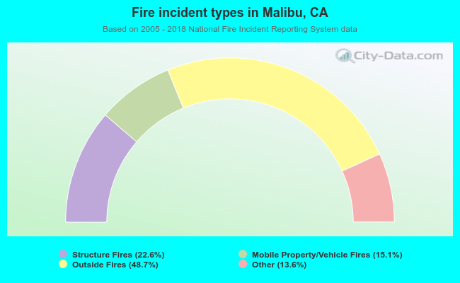 When looking into fire subcategories, the most incidents belonged to: Outside Fires (48.7%), and Structure Fires (22.6%).
| Most common first names in Malibu, CA among deceased individuals | ||
| Name | Count | Lived (average) |
|---|---|---|
| John | 87 | 72.4 years |
| Robert | 64 | 74.6 years |
| William | 61 | 77.5 years |
| Mary | 50 | 80.8 years |
| Charles | 45 | 75.8 years |
| George | 41 | 80.4 years |
| James | 40 | 75.1 years |
| Margaret | 37 | 80.8 years |
| Edward | 35 | 75.5 years |
| Ruth | 33 | 79.5 years |
| Most common last names in Malibu, CA among deceased individuals | ||
| Last name | Count | Lived (average) |
|---|---|---|
| Smith | 18 | 80.2 years |
| Johnson | 17 | 75.1 years |
| Brown | 16 | 76.1 years |
| Wilson | 14 | 78.3 years |
| Jones | 14 | 77.3 years |
| Clark | 12 | 72.7 years |
| Moore | 10 | 77.9 years |
| Scott | 10 | 78.9 years |
| Davis | 9 | 71.9 years |
| Cohen | 8 | 82.1 years |
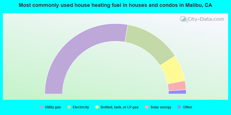
- 55.7%Utility gas
- 26.3%Electricity
- 12.1%Bottled, tank, or LP gas
- 4.2%Solar energy
- 1.5%No fuel used
- 0.3%Other fuel
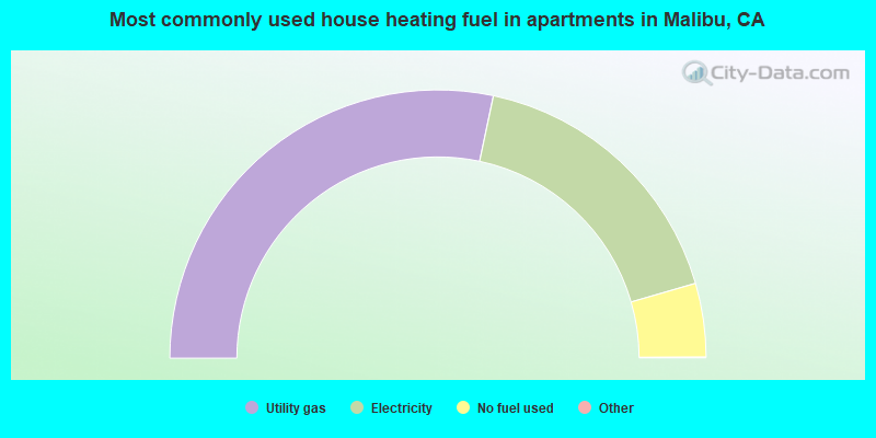
- 56.7%Utility gas
- 34.4%Electricity
- 8.9%No fuel used
Malibu compared to California state average:
- Median household income above state average.
- Median house value significantly above state average.
- Unemployed percentage significantly below state average.
- Black race population percentage significantly below state average.
- Hispanic race population percentage significantly below state average.
- Median age significantly above state average.
- Foreign-born population percentage below state average.
- Length of stay since moving in significantly above state average.
- Number of college students below state average.
- Percentage of population with a bachelor's degree or higher significantly above state average.
Malibu on our top lists:
- #5 on the list of "Top 101 cities with largest percentage of males in industries: information (population 5,000+)"
- #6 on the list of "Top 101 cities with largest percentage of males in occupations: arts, design, entertainment, sports, and media occupations (population 5,000+)"
- #13 on the list of "Top 101 cities with largest percentage of females in occupations: arts, design, entertainment, sports, and media occupations (population 5,000+)"
- #15 on the list of "Top 101 cities with the highest percentage of workers working at home, population 5,000+"
- #33 on the list of "Top 101 cities with the highest cost per building permit(population 5,000+)"
- #35 on the list of "Top 101 cities with largest percentage of females in industries: professional, scientific, and technical services (population 5,000+)"
- #59 on the list of "Top 101 cities with largest percentage of females in occupations: life, physical, and social science occupations (population 5,000+)"
- #65 on the list of "Top 101 cities with the most residents born in Europe, n.e.c. (population 500+)"
- #77 on the list of "Top 100 cities with highest median house value"
- #78 on the list of "Top 101 cities with largest percentage of workers with very long commute times (90 or more minutes) (population 5,000+)"
- #94 on the list of "Top 101 cities with the most residents born in Other Northern Europe (population 500+)"
- #14 (90265) on the list of "Top 101 zip codes with the largest percentage of taxpayers reporting profit/loss from business in 2012 (pop 5,000+)"
- #100 (90265) on the list of "Top 101 zip codes with the highest 2012 average taxable interest for individuals (pop 5,000+)"
- #1 on the list of "Top 101 counties with the most Evangelical Protestant congregations"
- #1 on the list of "Top 101 counties with the most Mainline Protestant congregations"
- #1 on the list of "Top 101 counties with the most Orthodox adherents"
- #1 on the list of "Top 101 counties with the highest ground withdrawal of fresh water for public supply (pop. 50,000+)"
- #1 on the list of "Top 101 counties with the most Catholic adherents (pop. 50,000+)"

|
|
Total of 726 patent applications in 2008-2024.