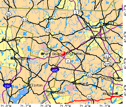
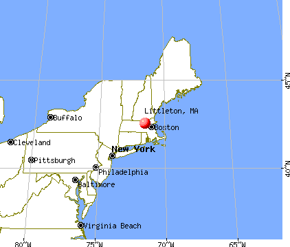
Littleton, Massachusetts

Submit your own pictures of this town and show them to the world
- OSM Map
- General Map
- Google Map
- MSN Map
Population change since 2000: +9.0%
 |
| Males: 4,290 | |
| Females: 4,634 |
| Median resident age: | 43.0 years |
| Massachusetts median age: | 39.2 years |
Zip codes: 01460.
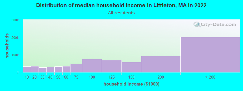
| Littleton: | $139,432 |
| MA: | $94,488 |
Estimated per capita income in 2022: $64,507 (it was $31,070 in 2000)
Littleton town income, earnings, and wages data
Estimated median house or condo value in 2022: $693,344 (it was $245,300 in 2000)
| Littleton: | $693,344 |
| MA: | $534,700 |
Mean prices in 2022: all housing units: $796,617; detached houses: $834,667; townhouses or other attached units: $772,440; in 2-unit structures: $786,250; in 3-to-4-unit structures: $655,835; in 5-or-more-unit structures: $590,321; mobile homes: $144,935
Detailed information about poverty and poor residents in Littleton, MA


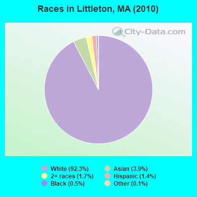
- 8,23992.3%White alone
- 3503.9%Asian alone
- 1501.7%Two or more races
- 1211.4%Hispanic
- 460.5%Black alone
- 120.1%Other race alone
- 60.07%American Indian alone
Races in Littleton detailed stats: ancestries, foreign born residents, place of birth
Type |
2009 |
2010 |
2011 |
2012 |
2013 |
2014 |
2015 |
2016 |
2017 |
2018 |
2019 |
2020 |
2021 |
2022 |
|---|---|---|---|---|---|---|---|---|---|---|---|---|---|---|
| Murders (per 100,000) | 0 (0.0) | 0 (0.0) | 0 (0.0) | 0 (0.0) | 0 (0.0) | 0 (0.0) | 0 (0.0) | 0 (0.0) | 0 (0.0) | 0 (0.0) | 0 (0.0) | 0 (0.0) | 0 (0.0) | 0 (0.0) |
| Rapes (per 100,000) | 2 (22.5) | 1 (11.2) | 1 (11.1) | 0 (0.0) | 4 (43.4) | 0 (0.0) | 5 (52.5) | 4 (39.7) | 2 (19.6) | 1 (9.7) | 5 (48.4) | 2 (19.4) | 2 (19.1) | 1 (9.8) |
| Robberies (per 100,000) | 1 (11.2) | 0 (0.0) | 0 (0.0) | 1 (11.0) | 0 (0.0) | 1 (10.7) | 0 (0.0) | 0 (0.0) | 0 (0.0) | 0 (0.0) | 0 (0.0) | 0 (0.0) | 0 (0.0) | 1 (9.8) |
| Assaults (per 100,000) | 14 (157.2) | 4 (44.8) | 9 (100.2) | 10 (109.9) | 5 (54.2) | 8 (85.6) | 11 (115.6) | 7 (69.5) | 9 (88.3) | 8 (77.7) | 6 (58.1) | 4 (38.7) | 3 (28.6) | 2 (19.7) |
| Burglaries (per 100,000) | 24 (269.5) | 29 (325.0) | 27 (300.7) | 35 (384.7) | 15 (162.7) | 24 (256.7) | 14 (147.1) | 10 (99.3) | 21 (206.0) | 6 (58.3) | 5 (48.4) | 3 (29.1) | 2 (19.1) | 3 (29.5) |
| Thefts (per 100,000) | 55 (617.6) | 60 (672.3) | 64 (712.9) | 73 (802.5) | 75 (813.5) | 42 (449.2) | 48 (504.4) | 63 (625.4) | 50 (490.4) | 48 (466.4) | 43 (416.1) | 33 (319.6) | 31 (295.8) | 39 (384.1) |
| Auto thefts (per 100,000) | 4 (44.9) | 5 (56.0) | 2 (22.3) | 5 (55.0) | 2 (21.7) | 3 (32.1) | 5 (52.5) | 5 (49.6) | 4 (39.2) | 2 (19.4) | 0 (0.0) | 2 (19.4) | 5 (47.7) | 3 (29.5) |
| Arson (per 100,000) | 0 (0.0) | 2 (22.4) | 0 (0.0) | 1 (11.0) | 1 (10.8) | 2 (21.4) | 0 (0.0) | 0 (0.0) | 0 (0.0) | 0 (0.0) | 0 (0.0) | 0 (0.0) | 0 (0.0) | 0 (0.0) |
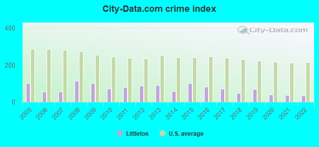
| City-Data.com crime index | 99.9 | 72.1 | 80.3 | 88.7 | 91.2 | 58.8 | 99.8 | 81.6 | 70.5 | 47.6 | 70.4 | 39.6 | 38.0 | 34.6 |
The City-Data.com crime index weighs serious crimes and violent crimes more heavily. Higher means more crime, U.S. average is 246.1. It adjusts for the number of visitors and daily workers commuting into cities.
Crime rate in Littleton detailed stats: murders, rapes, robberies, assaults, burglaries, thefts, arson
Full-time law enforcement employees in 2021, including police officers: 28 (20 officers - 18 male; 2 female).
| Officers per 1,000 residents here: | 1.91 |
| Massachusetts average: | 2.53 |
 Recent articles from our blog. Our writers, many of them Ph.D. graduates or candidates, create easy-to-read articles on a wide variety of topics.


 | Littleton or Westford (10 replies) |
| Littleton: Worth Moving if kids are young? (14 replies) |
| Chelmsford Relocation help - 495 Towns from Amesbury to Littleton (28 replies) |
| 2023 Real Estate Observations (5278 replies) |
| Concord Coach to Littleton NH (1 reply) |
| need advice on the price point of a house in Littleton MA (11 replies) |
Latest news from Littleton, MA collected exclusively by city-data.com from local newspapers, TV, and radio stations
Ancestries: Irish (27.5%), English (22.1%), Italian (15.6%), French (8.5%), German (8.3%), Polish (7.6%).
Current Local Time: EST time zone
Incorporated in 1715
Elevation: 229 feet
Land area: 16.6 square miles.
Population density: 537 people per square mile (low).
421 residents are foreign born (2.2% Europe, 1.5% Asia, 1.1% North America).
| This town: | 5.1% |
| Massachusetts: | 12.2% |
| Littleton town: | 1.2% ($2,947) |
| Massachusetts: | 1.3% ($2,336) |
Nearest city with pop. 50,000+: Lowell, MA  (11.3 miles , pop. 105,167).
Nearest city with pop. 200,000+: Boston, MA (25.5 miles , pop. 589,141).
Nearest city with pop. 1,000,000+: Bronx, NY (169.9 miles , pop. 1,332,650).
Nearest cities:
), ), Latitude: 42.54 N, Longitude: 71.49 W
Area code: 978

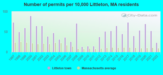
Single-family new house construction building permits:
- 2022: 19 buildings, average cost: $304,000
- 2021: 43 buildings, average cost: $262,500
- 2020: 57 buildings, average cost: $328,800
- 2019: 44 buildings, average cost: $360,200
- 2018: 33 buildings, average cost: $368,400
- 2017: 60 buildings, average cost: $368,800
- 2016: 37 buildings, average cost: $279,800
- 2015: 53 buildings, average cost: $277,000
- 2014: 43 buildings, average cost: $288,200
- 2013: 42 buildings, average cost: $284,100
- 2012: 31 buildings, average cost: $251,400
- 2011: 12 buildings, average cost: $182,000
- 2010: 12 buildings, average cost: $178,500
- 2009: 11 buildings, average cost: $205,900
- 2008: 58 buildings, average cost: $135,800
- 2007: 21 buildings, average cost: $223,900
- 2006: 30 buildings, average cost: $165,300
- 2005: 26 buildings, average cost: $200,300
- 2004: 39 buildings, average cost: $220,500
- 2003: 32 buildings, average cost: $237,000
- 2002: 53 buildings, average cost: $188,200
- 2001: 53 buildings, average cost: $191,200
- 2000: 73 buildings, average cost: $160,600
- 1999: 49 buildings, average cost: $126,600
- 1998: 41 buildings, average cost: $143,500
- 1997: 60 buildings, average cost: $129,200

| Here: | 3.1% |
| Massachusetts: | 3.5% |

- Professional, scientific, technical services (14.2%)
- Computer & electronic products (9.6%)
- Educational services (8.8%)
- Health care (8.4%)
- Construction (6.3%)
- Finance & insurance (4.0%)
- Accommodation & food services (3.8%)
- Computer & electronic products (14.8%)
- Professional, scientific, technical services (14.4%)
- Construction (10.5%)
- Educational services (6.2%)
- Finance & insurance (4.4%)
- Public administration (4.2%)
- Health care (3.7%)
- Professional, scientific, technical services (14.1%)
- Health care (14.0%)
- Educational services (11.9%)
- Accommodation & food services (5.6%)
- Administrative & support & waste management services (4.1%)
- Real estate & rental & leasing (4.1%)
- Finance & insurance (3.6%)
- Computer specialists (10.6%)
- Other management occupations, except farmers and farm managers (7.3%)
- Engineers (5.0%)
- Other sales and related occupations, including supervisors (4.5%)
- Other office and administrative support workers, including supervisors (3.0%)
- Preschool, kindergarten, elementary, and middle school teachers (3.0%)
- Sales representatives, services, wholesale and manufacturing (2.9%)
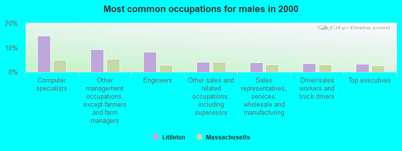
- Computer specialists (14.9%)
- Other management occupations, except farmers and farm managers (9.3%)
- Engineers (8.1%)
- Other sales and related occupations, including supervisors (4.1%)
- Sales representatives, services, wholesale and manufacturing (3.9%)
- Driver/sales workers and truck drivers (3.5%)
- Top executives (3.3%)

- Computer specialists (5.6%)
- Secretaries and administrative assistants (5.5%)
- Registered nurses (5.4%)
- Other management occupations, except farmers and farm managers (5.0%)
- Other sales and related occupations, including supervisors (4.9%)
- Other office and administrative support workers, including supervisors (4.2%)
- Preschool, kindergarten, elementary, and middle school teachers (4.0%)
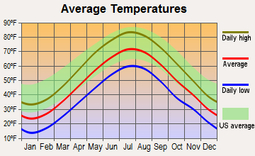
Average climate in Littleton, Massachusetts
Based on data reported by over 4,000 weather stations
(lower is better)
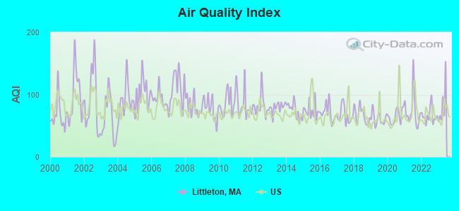
Air Quality Index (AQI) level in 2022 was 66.1. This is about average.
| City: | 66.1 |
| U.S.: | 72.6 |
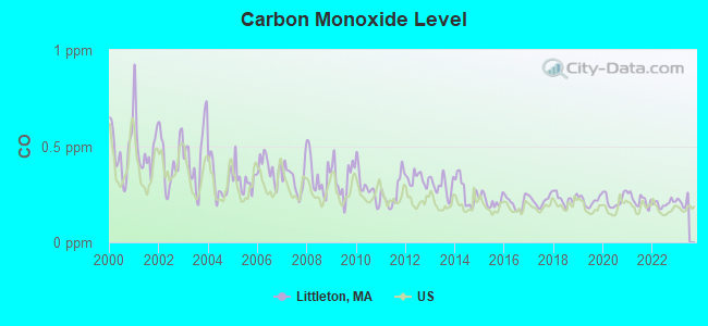
Carbon Monoxide (CO) [ppm] level in 2022 was 0.201. This is better than average. Closest monitor was 11.7 miles away from the city center.
| City: | 0.201 |
| U.S.: | 0.251 |
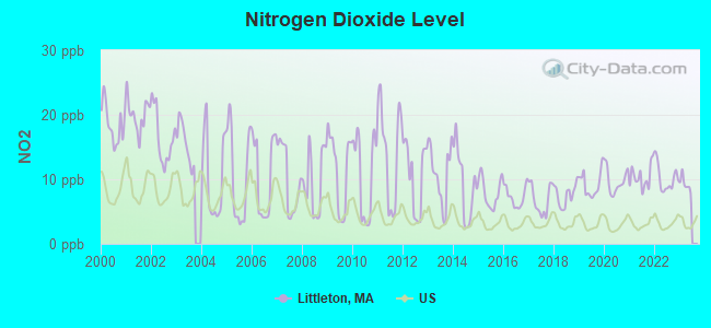
Nitrogen Dioxide (NO2) [ppb] level in 2022 was 10.1. This is significantly worse than average. Closest monitor was 4.3 miles away from the city center.
| City: | 10.1 |
| U.S.: | 5.1 |
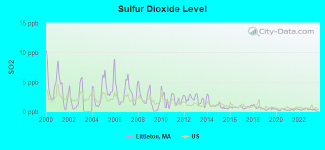
Sulfur Dioxide (SO2) [ppb] level in 2022 was 0.355. This is significantly better than average. Closest monitor was 4.3 miles away from the city center.
| City: | 0.355 |
| U.S.: | 1.515 |
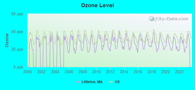
Ozone [ppb] level in 2022 was 25.9. This is better than average. Closest monitor was 8.9 miles away from the city center.
| City: | 25.9 |
| U.S.: | 33.3 |
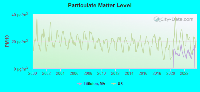
Particulate Matter (PM10) [µg/m3] level in 2022 was 10.6. This is significantly better than average. Closest monitor was 8.9 miles away from the city center.
| City: | 10.6 |
| U.S.: | 19.2 |

Particulate Matter (PM2.5) [µg/m3] level in 2022 was 6.52. This is better than average. Closest monitor was 8.8 miles away from the city center.
| City: | 6.52 |
| U.S.: | 8.11 |
Tornado activity:
Littleton-area historical tornado activity is slightly above Massachusetts state average. It is 28% smaller than the overall U.S. average.
On 6/9/1953, a category F4 (max. wind speeds 207-260 mph) tornado 16.7 miles away from the Littleton town center killed 90 people and injured 1228 people and caused between $50,000,000 and $500,000,000 in damages.
On 10/3/1970, a category F3 (max. wind speeds 158-206 mph) tornado 2.5 miles away from the town center killed one person and caused between $50,000 and $500,000 in damages.
Earthquake activity:
Littleton-area historical earthquake activity is significantly above Massachusetts state average. It is 72% smaller than the overall U.S. average.On 10/7/1983 at 10:18:46, a magnitude 5.3 (5.1 MB, 5.3 LG, 5.1 ML, Class: Moderate, Intensity: VI - VII) earthquake occurred 173.7 miles away from the city center
On 4/20/2002 at 10:50:47, a magnitude 5.3 (5.3 ML, Depth: 3.0 mi) earthquake occurred 175.6 miles away from Littleton center
On 1/19/1982 at 00:14:42, a magnitude 4.7 (4.5 MB, 4.7 MD, 4.5 LG, Class: Light, Intensity: IV - V) earthquake occurred 66.6 miles away from Littleton center
On 4/20/2002 at 10:50:47, a magnitude 5.2 (5.2 MB, 4.2 MS, 5.2 MW, 5.0 MW) earthquake occurred 175.0 miles away from the city center
On 10/16/2012 at 23:12:25, a magnitude 4.7 (4.7 ML, Depth: 10.0 mi) earthquake occurred 84.4 miles away from the city center
On 8/22/1992 at 12:20:32, a magnitude 4.8 (4.8 MB, 3.8 MS, 4.7 LG, Depth: 6.2 mi) earthquake occurred 245.3 miles away from the city center
Magnitude types: regional Lg-wave magnitude (LG), body-wave magnitude (MB), duration magnitude (MD), local magnitude (ML), surface-wave magnitude (MS), moment magnitude (MW)
Natural disasters:
The number of natural disasters in Middlesex County (31) is a lot greater than the US average (15).Major Disasters (Presidential) Declared: 17
Emergencies Declared: 14
Causes of natural disasters: Floods: 12, Storms: 9, Hurricanes: 6, Snowstorms: 6, Winter Storms: 5, Blizzards: 2, Snows: 2, Explosion: 1, Heavy Rain: 1, Snowfall: 1, Water Main Break: 1, Wind: 1 (Note: some incidents may be assigned to more than one category).

Hospitals and medical centers in Littleton:
Other hospitals and medical centers near Littleton:
- WESTFORD HOUSE (Nursing Home, about 4 miles away; WESTFORD, MA)
- WESTFORD NURSING HOME (Nursing Home, about 4 miles away; WESTFORD, MA)
- ACTON PUBLIC HEALTH NURSING SE (Home Health Center, about 5 miles away; ACTON, MA)
- WOODFORD OF AYER NURSING HOME (Nursing Home, about 5 miles away; AYER, MA)
- NASHOBA VALLEY MEDICAL CENTER Acute Care Hospitals (about 5 miles away; AYER, MA)
- APPLE VALLEY CENTER (Nursing Home, about 5 miles away; AYER, MA)
- APPLE VALLEY CONTINUING CARE CENTER (Nursing Home, about 5 miles away; AYER, MA)
Heliports located in Littleton:
Colleges/universities with over 2000 students nearest to Littleton:
- Middlesex Community College (about 12 miles; Bedford, MA; Full-time enrollment: 6,040)
- University of Massachusetts-Lowell (about 12 miles; Lowell, MA; FT enrollment: 12,341)
- Fitchburg State University (about 16 miles; Fitchburg, MA; FT enrollment: 5,010)
- Framingham State University (about 18 miles; Framingham, MA; FT enrollment: 5,743)
- Brandeis University (about 18 miles; Waltham, MA; FT enrollment: 6,966)
- Bentley University (about 18 miles; Waltham, MA; FT enrollment: 5,229)
- Wellesley College (about 20 miles; Wellesley, MA; FT enrollment: 2,658)
Public high school in Littleton:
- LITTLETON HIGH SCHOOL (Students: 386, Location: 56 KING STREET, Grades: 9-12)
Public elementary/middle schools in Littleton:
- SHAKER LANE ELEMENTARY (Students: 455, Location: 35 SHAKER LANE, Grades: PK-2)
- RUSSELL ST ELEMENTARY (Students: 379, Location: 57 RUSSELL STREET, Grades: 3-5)
- LITTLETON MIDDLE SCHOOL (Students: 335, Location: 55 RUSSELL STREET, Grades: 6-8)
Private elementary/middle school in Littleton:
Points of interest:
Notable locations in Littleton: Littleton-495 Station (A), Liberty Square (B), Littleton Fire Department (C), Littleton Middle School Library (D), Houghton Memorial Building (E), Littleton Common Town Hall (F), Reuben Hoar Library (G). Display/hide their locations on the map
Shopping Center: Nashoba Valley Shopping Center (1). Display/hide its location on the map
Churches in Littleton include: Stork Support Congregational Church (A), Littleton First Baptist Church (B), First Church Unitarian (C), The Church of Jesus Christ of Latter Day Saints (D), Abundant Life Assembly Church (E). Display/hide their locations on the map
Cemetery: Westlawn Cemetery (1). Display/hide its location on the map
Lakes, reservoirs, and swamps: Cobbs Pond (A), Black Pond (B), Spectacle Pond (C), Fort Pond (D), Long Pond (E), Nagog Pond (F), Mill Pond (G), Browns Swamp (H). Display/hide their locations on the map
Streams, rivers, and creeks: Long Pond Brook (A), Half Moon Brook (B), Bennetts Brook (C), Gilson Brook (D). Display/hide their locations on the map
Park in Littleton: Fat Park (1). Display/hide its location on the map
Tourist attraction: Littleton Historical Society Inc (Historical Places & Services; 4 Rogers Street) (1). Display/hide its approximate location on the map
Hotels: Nashoba Concierge Service (81 Taylor Street) (1), Lyttleton Inn Inc (423 King Street) (2). Display/hide their approximate locations on the map
Birthplace of: Harrison Reed (politician) - 9th Governor of Florida, Ed Fletcher - Politician, Matt Smith - College basketball player (Northeastern Huskies), Shawn Andrews (actor) - Actor.
Drinking water stations with addresses in Littleton and their reported violations in the past:
LITTLETON WATER DEPARTMENT (Population served: 8,566, Groundwater):Past health violations:CAMP NASHOBA - NORTH (Serves ME, Population served: 275, Groundwater):Past monitoring violations:
- MCL, Monthly (TCR) - In OCT-2009, Contaminant: Coliform. Follow-up actions: St AO (w/o penalty) issued (NOV-19-2009), St Compliance achieved (NOV-19-2009)
- MCL, Monthly (TCR) - In JUL-2009, Contaminant: Coliform. Follow-up actions: St AO (w/o penalty) issued (AUG-25-2009), St Compliance achieved (OCT-08-2009)
- MCL, Acute (TCR) - In JUN-2009, Contaminant: Coliform. Follow-up actions: St AO (w/o penalty) issued (AUG-25-2009), St Compliance achieved (OCT-08-2009)
- MCL, Monthly (TCR) - In JUN-2009, Contaminant: Coliform. Follow-up actions: St AO (w/o penalty) issued (AUG-25-2009), St Compliance achieved (OCT-08-2009)
- Monitoring and Reporting (DBP) - Between JUL-2012 and SEP-2012, Contaminant: Bromate. Follow-up actions: St AO (w/o penalty) issued (DEC-05-2012), St Compliance achieved (JAN-01-2013)
- Monitoring and Reporting (DBP) - Between JAN-2011 and MAR-2011, Contaminant: Bromate. Follow-up actions: St AO (w/o penalty) issued (JUN-07-2011), St Compliance achieved (JUL-14-2011)
- 2 minor monitoring violations
- One regular monitoring violation
Past monitoring violations:
- 2 routine major monitoring violations
| This town: | 2.7 people |
| Massachusetts: | 2.5 people |
| This town: | 73.1% |
| Whole state: | 63.0% |
| This town: | 5.2% |
| Whole state: | 7.0% |
Likely homosexual households (counted as self-reported same-sex unmarried-partner households)
- Lesbian couples: 0.7% of all households
- Gay men: 0.2% of all households
| This town: | 3.6% |
| Whole state: | 9.3% |
| This town: | 1.5% |
| Whole state: | 4.4% |
People in group quarters in Littleton in 2010:
- 113 people in nursing facilities/skilled-nursing facilities
- 18 people in group homes intended for adults
- 12 people in group homes for juveniles (non-correctional)
21 people in homes for the mentally ill in 2000
Banks with branches in Littleton (2011 data):
- Middlesex Savings Bank: Littleton Branch at 308 Great Road, branch established on 2000/10/02. Info updated 2009/07/16: Bank assets: $4,034.8 mil, Deposits: $3,490.0 mil, headquarters in Natick, MA, positive income, Mortgage Lending Specialization, 33 total offices, Holding Company: Middlesex Bancorp Mhc
- RBS Citizens, National Association: Littleton Branch at 272 Great Road, branch established on 1972/01/01. Info updated 2007/09/19: Bank assets: $106,940.6 mil, Deposits: $75,690.2 mil, headquarters in Providence, RI, positive income, 1135 total offices, Holding Company: Uk Financial Investments Limited
- North Middlesex Savings Bank: Littleton Branch at 220 Great Road, branch established on 1986/11/19. Info updated 2006/11/03: Bank assets: $329.3 mil, Deposits: $268.7 mil, headquarters in Ayer, MA, positive income, Commercial Lending Specialization, 7 total offices
- Northern Bank & Trust Company: Littleton Branch at 265 Great Road, branch established on 1892/01/01. Info updated 2012/02/08: Bank assets: $734.7 mil, Deposits: $586.1 mil, headquarters in Woburn, MA, positive income, Commercial Lending Specialization, 11 total offices, Holding Company: Northern Bancorp, Inc.
- Bank of America, National Association: Littleton Branch at 288 Great Road, branch established on 1959/12/01. Info updated 2009/11/18: Bank assets: $1,451,969.3 mil, Deposits: $1,077,176.8 mil, headquarters in Charlotte, NC, positive income, 5782 total offices, Holding Company: Bank Of America Corporation
For population 15 years and over in Littleton:
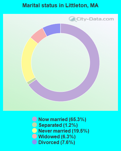
- Never married: 19.5%
- Now married: 65.3%
- Separated: 1.2%
- Widowed: 6.3%
- Divorced: 7.6%
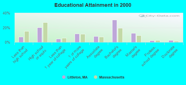
For population 25 years and over in Littleton:
- High school or higher: 92.6%
- Bachelor's degree or higher: 48.1%
- Graduate or professional degree: 17.6%
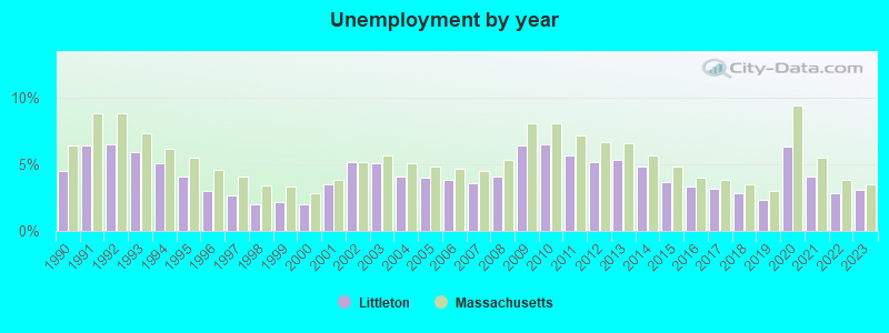
- Unemployed: 1.7%
- Mean travel time to work (commute): 30.4 minutes
| Here: | 10.4 |
| Massachusetts average: | 13.1 |


Graphs represent county-level data. Detailed 2008 Election Results
Religion statistics for Littleton, MA (based on Middlesex County data)


| Religion | Adherents | Congregations |
|---|---|---|
| Catholic | 718,209 | 107 |
| Mainline Protestant | 70,053 | 269 |
| Other | 68,480 | 199 |
| Evangelical Protestant | 41,270 | 304 |
| Orthodox | 23,641 | 28 |
| Black Protestant | 2,276 | 8 |
| None | 579,156 | - |
Food Environment Statistics:
| Middlesex County: | 1.71 / 10,000 pop. |
| State: | 1.98 / 10,000 pop. |
| Here: | 0.03 / 10,000 pop. |
| State: | 0.05 / 10,000 pop. |
| Here: | 2.14 / 10,000 pop. |
| Massachusetts: | 2.22 / 10,000 pop. |
| Here: | 1.38 / 10,000 pop. |
| State: | 1.77 / 10,000 pop. |
| Here: | 7.84 / 10,000 pop. |
| Massachusetts: | 8.76 / 10,000 pop. |
| Middlesex County: | 7.8% |
| Massachusetts: | 8.1% |
| Middlesex County: | 21.5% |
| Massachusetts: | 22.5% |
| This county: | 18.0% |
| Massachusetts: | 16.5% |
6.91% of this county's 2021 resident taxpayers lived in other counties in 2020 ($102,955 average adjusted gross income)
| Here: | 6.91% |
| Massachusetts average: | 6.35% |
0.01% of residents moved from foreign countries ($137 average AGI)
Middlesex County: 0.01% Massachusetts average: 0.01%
Top counties from which taxpayers relocated into this county between 2020 and 2021:
| from Suffolk County, MA | |
| from Essex County, MA | |
| from Norfolk County, MA |
8.22% of this county's 2020 resident taxpayers moved to other counties in 2021 ($123,369 average adjusted gross income)
| Here: | 8.22% |
| Massachusetts average: | 7.18% |
0.01% of residents moved to foreign countries ($124 average AGI)
Middlesex County: 0.01% Massachusetts average: 0.02%
Top counties to which taxpayers relocated from this county between 2020 and 2021:
| to Suffolk County, MA | |
| to Essex County, MA | |
| to Worcester County, MA |
| Businesses in Littleton, MA | ||||
| Name | Count | Name | Count | |
|---|---|---|---|---|
| CVS | 1 | Subway | 1 | |
| Decora Cabinetry | 2 | The Room Place | 1 | |
| Dunkin Donuts | 4 | Toyota | 1 | |
| FedEx | 3 | UPS | 4 | |
| MasterBrand Cabinets | 2 | |||
Strongest AM radio stations in Littleton:
- WRKO (680 AM; 50 kW; BOSTON, MA; Owner: ENTERCOM BOSTON LICENSE, LLC)
- WKOX (1200 AM; 50 kW; FRAMINGHAM, MA; Owner: CAPSTAR TX LIMITED PARTNERSHIP)
- WEEI (850 AM; 50 kW; BOSTON, MA; Owner: ENTERCOM BOSTON LICENSE, LLC)
- WBIX (1060 AM; 40 kW; NATICK, MA; Owner: LANGER BROADCASTING CORPORATION)
- WWZN (1510 AM; 50 kW; BOSTON, MA; Owner: ROSE CITY RADIO CORPORATION)
- WBNW (1120 AM; 5 kW; CONCORD, MA; Owner: MONEY MATTERS RADIO, INC.)
- WAMG (890 AM; 25 kW; DEDHAM, MA; Owner: MEGA COMMUNICATIONS OF DEDHAM LICENSEE, LLC)
- WCRN (830 AM; 50 kW; WORCESTER, MA; Owner: CARTER BROADCASTING CORPORATION)
- WRCA (1330 AM; 25 kW; WALTHAM, MA; Owner: WRCA LICENSE, LLC)
- WCAP (980 AM; 5 kW; LOWELL, MA; Owner: NORTHEAST RADIO, INC.)
- WAZN (1470 AM; 7 kW; MARLBOROUGH, MA; Owner: MULTICULTURAL RADIO BROADCASTING, INC.)
- WBZ (1030 AM; 50 kW; BOSTON, MA; Owner: INFINITY BROADCASTING OPERATIONS, INC.)
- WALE (990 AM; 50 kW; GREENVILLE, RI; Owner: NORTH AMERICAN BROADCASTING CO., INC.)
Strongest FM radio stations in Littleton:
- WBMX (98.5 FM; BOSTON, MA; Owner: INFINITY RADIO OPERATIONS INC.)
- WJMN (94.5 FM; BOSTON, MA; Owner: AMFM RADIO LICENSES, L.L.C.)
- WCRB (102.5 FM; WALTHAM, MA; Owner: CHARLES RIVER BROADCASTING WCRB LICE)
- WTKK (96.9 FM; BOSTON, MA; Owner: GREATER BOSTON RADIO, INC.)
- WROR-FM (105.7 FM; FRAMINGHAM, MA; Owner: GREATER BOSTON RADIO, INC.)
- WBOS (92.9 FM; BROOKLINE, MA; Owner: GREATER BOSTON RADIO, INC.)
- WGBH (89.7 FM; BOSTON, MA; Owner: WGBH EDUCATIONAL FOUNDATION)
- WBUR-FM (90.9 FM; BOSTON, MA; Owner: TRUSTEES OF BOSTON UNIVERSITY)
- WXKS-FM (107.9 FM; MEDFORD, MA; Owner: AMFM RADIO LICENSES, L.L.C.)
- WKLB-FM (99.5 FM; LOWELL, MA; Owner: GREATER BOSTON RADIO, INC.)
- WMJX (106.7 FM; BOSTON, MA; Owner: GREATER BOSTON RADIO, INC.)
- WHOB (106.3 FM; NASHUA, NH; Owner: TELE-MEDIA COMPANY OF NEW HAMPSHIRE, L.L.C.)
- WODS (103.3 FM; BOSTON, MA; Owner: INFINITY BROADCASTING OPERATIONS, INC.)
- WXLO (104.5 FM; FITCHBURG, MA; Owner: CITADEL BROADCASTING COMPANY)
- WFEX (92.1 FM; PETERBOROUGH, NH; Owner: FNX BROADCASTING OF NEW HAMPSHIRE LLC)
- W227AM (93.3 FM; ANDOVER, MA; Owner: GREATER BOSTON RADIO, INC.)
- WAAF (107.3 FM; WORCESTER, MA; Owner: ENTERCOM BOSTON LICENSE, LLC)
- WSRS (96.1 FM; WORCESTER, MA; Owner: CAPSTAR TX LIMITED PARTNERSHIP)
- WBCN (104.1 FM; BOSTON, MA; Owner: HEMISPHERE BROADCASTING CORPORATION)
- WZLX (100.7 FM; BOSTON, MA; Owner: INFINITY BROADCASTING CORPORATION OF BOSTON)
TV broadcast stations around Littleton:
- WUTF (Channel 66; MARLBOROUGH, MA; Owner: TELEFUTURA BOSTON LLC)
- WCVB-TV (Channel 5; BOSTON, MA; Owner: WCVB HEARST-ARGYLE TV, INC.)
- WGBH-TV (Channel 2; BOSTON, MA; Owner: WGBH EDUCATIONAL FOUNDATION)
- WUNI (Channel 27; WORCESTER, MA; Owner: ENTRAVISION HOLDINGS, LLC)
- WHDH-TV (Channel 7; BOSTON, MA; Owner: WHDH-TV)
- WMFP (Channel 62; LAWRENCE, MA; Owner: WSAH LICENSE, INC.)
- WBZ-TV (Channel 4; BOSTON, MA; Owner: VIACOM INC.)
- WGBX-TV (Channel 44; BOSTON, MA; Owner: WGBH EDUCATIONAL FOUNDATION)
- WSBK-TV (Channel 38; BOSTON, MA; Owner: VIACOM INC.)
- WLVI-TV (Channel 56; CAMBRIDGE, MA; Owner: WLVI, INC.)
- WFXT (Channel 25; BOSTON, MA; Owner: FOX TELEVISION STATIONS INC.)
- WFXZ-CA (Channel 24; BOSTON, MA; Owner: BOSTON BROADCASTING CORP.)
- W40BO (Channel 40; BOSTON, MA; Owner: PAXSON COMMUNICATIONS LPTV, INC.)
- WBPX (Channel 68; BOSTON, MA; Owner: PAXSON BOSTON-68 LICENSE, INC.)
- WNDS (Channel 50; DERRY, NH; Owner: CTV OF DERRY, INC)
- WTMU-LP (Channel 32; BOSTON, MA; Owner: ZGS BOSTON, INC.)
- WCEA-LP (Channel 58; BOSTON, MA; Owner: CHANNEL 19 TV CORPORATION)
- WYDN (Channel 48; WORCESTER, MA; Owner: EDUCATIONAL PUBLIC TV CORPORATION)
- WWDP (Channel 46; NORWELL, MA; Owner: NORWELL TELEVISION, LLC)
- W33AK (Channel 33; NASHUA, NH; Owner: CENTER B/CING CORPORATION OF NEW HAMPSHIRE)
- WYCN-LP (Channel 13; NASHUA, NH; Owner: CENTER BROADCASTING CORP. OF NEW HAMPSHIRE)

- National Bridge Inventory (NBI) Statistics
- 33Number of bridges
- 341ft / 104mTotal length
- $56,152,000Total costs
- 1,171,360Total average daily traffic
- 72,788Total average daily truck traffic
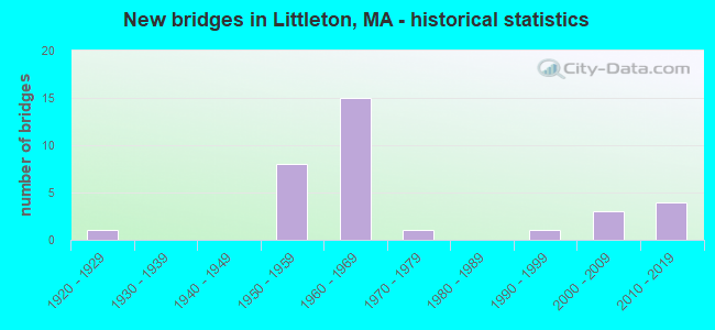
- New bridges - historical statistics
- 11920-1929
- 81950-1959
- 151960-1969
- 11970-1979
- 11990-1999
- 32000-2009
- 42010-2019
FCC Registered Antenna Towers:
50 (See the full list of FCC Registered Antenna Towers in Littleton)FCC Registered Private Land Mobile Towers:
1- 563 Newton Rd. (Lat: 42.516750 Lon: -71.474222), Type: Tower, Structure height: 40 m, Call Sign: WPLA741,
Assigned Frequencies: 862.037 MHz, 862.062 MHz, 862.087 MHz, 862.112 MHz, 862.137 MHz, 862.162 MHz, 862.187 MHz, 862.212 MHz, 862.237 MHz, 862.262 MHz... (+148 more), Grant Date: 02/28/2012, Expiration Date: 02/06/2022, Cancellation Date: 09/12/2019, Registrant: Sprint Corporation, 12502 Sunrise Valley Drive, M/S: Varesa-0209, Reston, VA 20196, Phone: (800) 572-8256, Fax: (703) 433-4483, Email:
FCC Registered Broadcast Land Mobile Towers:
5- 20 Foster St (Lat: 42.538139 Lon: -71.483667), Call Sign: KDG722, Licensee ID: L00030585,
Assigned Frequencies: 33.6600 MHz, Grant Date: 11/30/2000, Expiration Date: 01/31/2011, Cancellation Date: 04/02/2011, Registrant: Littleton, Town Of, 20 Foster St, Littleton, MA 01460, Phone: (508) 952-2302
- Lat: 42.476111 Lon: -71.411389, Call Sign: WPSZ448,
Assigned Frequencies: 153.065 MHz, Grant Date: 08/13/2001, Expiration Date: 08/13/2011, Cancellation Date: 10/15/2011, Certifier: David W Quinn, Registrant: Federal Licensing Inc, 1588 Fairfield Road, Gettysburg, PA 17325, Phone: (717) 334-9262, Fax: (717) 334-6440
- Mass Ave (Lat: 42.485278 Lon: -71.543083), Type: Bant, Structure height: 7 m, Overall height: 9.1 m, Call Sign: WQJE994,
Assigned Frequencies: 456.787 MHz, Grant Date: 06/08/2018, Expiration Date: 08/18/2028, Certifier: Savas C Danos, Registrant: Cyber Communications, Inc., 100 Fireworks Circle, Bridgewater, MA 02324, Phone: (508) 880-3294, Fax: (508) 880-6745, Email:
- Lat: 42.538139 Lon: -71.483667, Call Sign: WQKN738,
Assigned Frequencies: 458.975 MHz, Grant Date: 07/11/2019, Expiration Date: 07/28/2029, Certifier: Alexander S Mc Curdy Iii, Registrant: Cyber Communications, Inc., 100 Fireworks Circle, Bridgewater, MA 02324, Phone: (508) 880-3294, Fax: (508) 880-6745, Email:
- DISTRIBUTION CENTER, Lat: 42.547889 Lon: -71.517472, Call Sign: WQXF874,
Assigned Frequencies: 456.662 MHz, 456.712 MHz, Grant Date: 02/23/2016, Expiration Date: 02/23/2026, Certifier: Jim Phinney, Registrant: Northeast Two Way Radio Corp., 5 Birch St, Unit 6, Wilmington, MA 01887, Phone: (978) 532-1160, Email:
FCC Registered Microwave Towers:
5- LITTLETON, 451 Newtown Rd. (Lat: 42.524806 Lon: -71.463111), Type: Tower, Structure height: 68 m, Call Sign: WMR440,
Assigned Frequencies: 10628.7 MHz, 10638.1 MHz, Grant Date: 01/25/2011, Expiration Date: 02/01/2021, Cancellation Date: 02/19/2014, Registrant: Verizon Wireless, 1120 Sanctuary Pkwy, #150 Gasa5reg, Alpharetta, GA 30009-7630, Phone: (770) 797-1070, Fax: (770) 797-1036, Email:
- LITTLETON ELW DEPT, Various Locations (Lat: 42.600639 Lon: -71.377278), Overall height: 2.4 m, Call Sign: WPOU600,
Assigned Frequencies: 956.406 MHz, Grant Date: 07/15/1999, Expiration Date: 07/15/2009, Cancellation Date: 09/19/2009, Phone: (724) 430-3974
- BOS0611, 1 Cedar Rd. & Birch (Lat: 42.534750 Lon: -71.472778), Type: Tank, Structure height: 35.1 m, Overall height: 36.6 m, Call Sign: WQBM820, Licensee ID: L01728370,
Assigned Frequencies: 11365.0 MHz, 11285.0 MHz, Grant Date: 11/08/2004, Expiration Date: 11/08/2014, Cancellation Date: 09/09/2013, Certifier: Joseph M Sandri Jr., Registrant: Fibertower Network Services, Corp., Debtor-In-Possession, 1875 Eye Street, Nw, 5th Floor, Room 505, Washington, DC 20006, Phone: (202) 223-1028, Email:
- LITTLETON, Lat: 42.543278 Lon: -71.516306, Call Sign: WQNI648,
Assigned Frequencies: 956.331 MHz, Grant Date: 01/28/2021, Expiration Date: 02/16/2031, Certifier: Savas Danos, Registrant: Sensus, 450 N Gallatin Avenue, Uniontown, PA 15401, Phone: (800) 638-3748, Fax: (800) 888-2403, Email:
- LITTLETON, 451 Newtown Rd (Lat: 42.524806 Lon: -71.463111), Overall height: 68.6 m, Call Sign: KCM82,
Assigned Frequencies: 3710.00 MHz, 3890.00 MHz, 3970.00 MHz, 4030.00 MHz, Grant Date: 02/15/2000, Expiration Date: 02/01/2010, Cancellation Date: 05/01/2000, Phone: (404) 810-4021
FCC Registered Paging Towers:
2- 153 Taylor Street (Lat: 42.522028 Lon: -71.512000), Call Sign: KCI297, Licensee ID: L01422065,
Assigned Frequencies: 454.175 MHz, Grant Date: 05/05/2009, Expiration Date: 04/01/2019, Cancellation Date: 07/13/2010, Certifier: Shawn E Endsley, Registrant: Usa Mobility Wireless, Inc., 3000 Technology Dr. #400, Plano, TX 75074, Phone: (972) 801-0000, Fax: (972) 801-1699, Email:
- Junction Of Great Road And King Street (Lat: 42.550083 Lon: -71.468944), Call Sign: KCI297, Licensee ID: L01422065,
Assigned Frequencies: 454.175 MHz, Grant Date: 05/05/2009, Expiration Date: 04/01/2019, Cancellation Date: 07/13/2010, Certifier: Shawn E Endsley, Registrant: Usa Mobility Wireless, Inc., 3000 Technology Dr. #400, Plano, TX 75074, Phone: (972) 801-0000, Fax: (972) 801-1699, Email:
FCC Registered Amateur Radio Licenses:
105 (See the full list of FCC Registered Amateur Radio Licenses in Littleton)FAA Registered Aircraft:
9 (See the full list of FAA Registered Aircraft in Littleton)2002 - 2018 National Fire Incident Reporting System (NFIRS) incidents
- Fire incident types reported to NFIRS in Littleton, MA
- 38345.8%Structure Fires
- 21725.9%Outside Fires
- 19423.2%Mobile Property/Vehicle Fires
- 435.1%Other
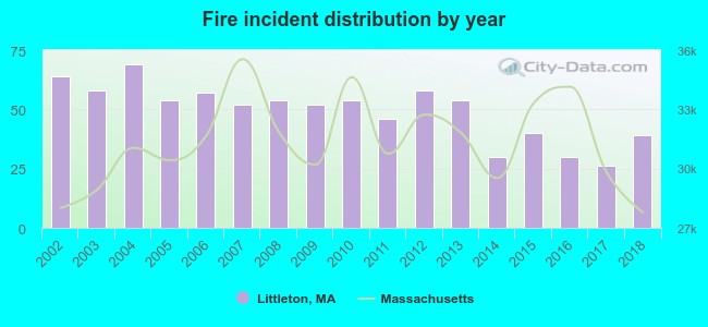 Based on the data from the years 2002 - 2018 the average number of fires per year is 49. The highest number of fire incidents - 69 took place in 2004, and the least - 26 in 2017. The data has a dropping trend.
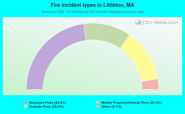 When looking into fire subcategories, the most incidents belonged to: Structure Fires (45.8%), and Outside Fires (25.9%).
- 62.5%Fuel oil, kerosene, etc.
- 28.5%Utility gas
- 5.5%Electricity
- 3.5%Bottled, tank, or LP gas
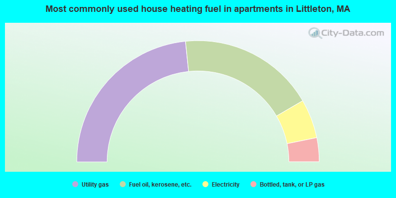
- 46.7%Utility gas
- 36.5%Fuel oil, kerosene, etc.
- 10.4%Electricity
- 6.4%Bottled, tank, or LP gas
Littleton compared to Massachusetts state average:
- Unemployed percentage significantly below state average.
- Black race population percentage significantly below state average.
- Hispanic race population percentage significantly below state average.
- Foreign-born population percentage significantly below state average.
- Renting percentage significantly below state average.
- Length of stay since moving in significantly above state average.
- Number of rooms per house significantly below state average.
- House age significantly below state average.
Littleton on our top lists:
- #4 on the list of "Top 101 cities with largest percentage of males in occupations: computer specialists (population 5,000+)"
- #8 on the list of "Top 101 cities with largest percentage of males in industries: computer and electronic products (population 5,000+)"
- #13 on the list of "Top 101 cities with largest percentage of females in occupations: computer specialists (population 5,000+)"
- #14 on the list of "Top 101 cities with largest percentage of females in industries: radio, tv, and computer stores (population 5,000+)"
- #17 on the list of "Top 101 cities with largest percentage of females in industries: leather and allied products (population 5,000+)"
- #21 on the list of "Top 101 cities with largest percentage of males in occupations: judges, magistrates, and other judicial workers (population 5,000+)"
- #22 on the list of "Top 101 cities with largest percentage of males in occupations: life and physical scientists (population 5,000+)"
- #23 on the list of "Top 101 cities with largest percentage of females in occupations: librarians, curators, and archivists (population 5,000+)"
- #24 on the list of "Top 101 cities with largest percentage of females in occupations: special education teachers (population 5,000+)"
- #35 on the list of "Top 101 cities with largest percentage of males in industries: retail florists (population 5,000+)"
- #48 on the list of "Top 101 cities with largest percentage of females in industries: apparel, fabrics, and notions merchant wholesalers (population 5,000+)"
- #48 on the list of "Top 101 cities with largest percentage of females in industries: professional and commercial equipment and supplies merchant wholesalers (population 5,000+)"
- #53 on the list of "Top 101 cities with largest percentage of females in industries: office supplies and stationery stores (population 5,000+)"
- #61 on the list of "Top 101 cities with largest percentage of males in industries: radio, tv, and computer stores (population 5,000+)"
- #67 on the list of "Top 101 cities with largest percentage of males in industries: office supplies and stationery stores (population 5,000+)"
- #75 on the list of "Top 101 cities with largest percentage of females in industries: data processing, libraries, and other information services (population 5,000+)"
- #80 on the list of "Top 101 cities with largest percentage of males in industries: private households (population 5,000+)"
- #80 on the list of "Top 100 high-educated but low-earning cities (pop. 5,000+)"
- #88 on the list of "Top 101 cities with largest percentage of females in industries: nonmetallic mineral products (population 5,000+)"
- #4 on the list of "Top 101 counties with the most Orthodox adherents"
- #7 on the list of "Top 101 counties with the most Catholic adherents"
- #7 on the list of "Top 101 counties with the most Mainline Protestant congregations"
- #7 on the list of "Top 101 counties with the most Orthodox congregations"
- #8 on the list of "Top 101 counties with the lowest percentage of residents that keep firearms around their homes"

|
|
Total of 917 patent applications in 2008-2024.