Leyden, Massachusetts
Leyden

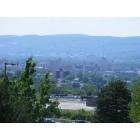
Leyden: Mushroom with a Tenant
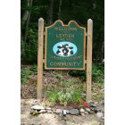
Leyden: Leyden Welcome Sign
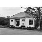
Leyden: Robertson Memorial Library - Leyden, MA
- add
your


Submit your own pictures of this town and show them to the world
- OSM Map
- General Map
- Google Map
- MSN Map

Population change since 2000: -7.9%
 |
| Males: 364 | |
| Females: 347 |
| Median resident age: | 49.0 years |
| Massachusetts median age: | 39.2 years |
Zip codes: 01301.
| Leyden: | $86,891 |
| MA: | $94,488 |
Estimated per capita income in 2022: $47,509 (it was $26,076 in 2000)
Leyden town income, earnings, and wages data
Estimated median house or condo value in 2022: $374,764 (it was $150,800 in 2000)
| Leyden: | $374,764 |
| MA: | $534,700 |
Mean prices in 2022: all housing units: $313,377; detached houses: $324,224; townhouses or other attached units: $284,225; in 2-unit structures: $287,978; in 3-to-4-unit structures: $183,938; in 5-or-more-unit structures: $249,762; mobile homes: $62,200
Detailed information about poverty and poor residents in Leyden, MA


- 69397.5%White alone
- 81.1%Asian alone
- 81.1%Hispanic
- 20.3%Two or more races

Races in Leyden detailed stats: ancestries, foreign born residents, place of birth
 Recent articles from our blog. Our writers, many of them Ph.D. graduates or candidates, create easy-to-read articles on a wide variety of topics.


 | Is it possible to escape hunters, ATVs and noise in a rural area? (278 replies) |
| Could my young family be happy in MA? (152 replies) |
| Possibilities in Western Mass for mid-life couple w/no kids (22 replies) |
| What is the best MA community for a summer home? (30 replies) |
| Opinions on Northfield, Shelburne Falls (14 replies) |
| Pioneer Valley: Wood Stoves + Well/Spring Water? (31 replies) |
Latest news from Leyden, MA collected exclusively by city-data.com from local newspapers, TV, and radio stations
Ancestries: English (21.8%), Irish (14.9%), German (11.0%), Polish (10.2%), French (9.5%), French Canadian (5.6%).
Current Local Time: EST time zone
Elevation: 969 feet
Land area: 18.0 square miles.
Population density: 40 people per square mile (very low).

5 residents are foreign born
| This town: | 0.6% |
| Massachusetts: | 12.2% |
| Leyden town: | 1.5% ($2,226) |
| Massachusetts: | 1.3% ($2,336) |
Nearest city with pop. 50,000+: Chicopee, MA  (36.6 miles , pop. 54,653).
Nearest city with pop. 200,000+: Boston, MA (82.7 miles , pop. 589,141).
Nearest city with pop. 1,000,000+: Bronx, NY (143.3 miles , pop. 1,332,650).
Nearest cities:
), ), Latitude: 42.70 N, Longitude: 72.63 W
Area code commonly used in this area: 413


Single-family new house construction building permits:
- 2020: 2 buildings, average cost: $265,000
- 2019: 2 buildings, average cost: $812,500
- 2018: 1 building, cost: $190,000
- 2016: 1 building, cost: $216,000
- 2014: 1 building, cost: $195,000
- 2013: 2 buildings, average cost: $339,500
- 2012: 1 building, cost: $391,700
- 2011: 2 buildings, average cost: $342,000
- 2010: 3 buildings, average cost: $325,100
- 2009: 3 buildings, average cost: $288,500
- 2008: 4 buildings, average cost: $442,700
- 2007: 4 buildings, average cost: $163,700
- 2005: 1 building, cost: $174,100
- 2004: 5 buildings, average cost: $200,300
- 2003: 6 buildings, average cost: $197,800
- 2002: 3 buildings, average cost: $137,800
- 2001: 6 buildings, average cost: $120,400
- 2000: 4 buildings, average cost: $143,200
- 1999: 6 buildings, average cost: $120,800
- 1998: 3 buildings, average cost: $114,400
- 1997: 3 buildings, average cost: $91,000


| Here: | 2.3% |
| Massachusetts: | 3.5% |


- Educational services (12.8%)
- Construction (7.7%)
- Health care (7.5%)
- Accommodation & food services (7.5%)
- Administrative & support & waste management services (5.3%)
- Miscellaneous manufacturing (4.0%)
- Truck transportation (3.8%)

- Construction (13.3%)
- Educational services (9.3%)
- Agriculture, forestry, fishing & hunting (5.6%)
- Accommodation & food services (5.2%)
- Administrative & support & waste management services (5.2%)
- Miscellaneous manufacturing (4.4%)
- Professional, scientific, technical services (4.0%)

- Educational services (17.2%)
- Health care (13.2%)
- Accommodation & food services (10.3%)
- Finance & insurance (5.9%)
- Administrative & support & waste management services (5.4%)
- Miscellaneous manufacturing (3.4%)
- Public administration (3.4%)

- Other management occupations, except farmers and farm managers (8.0%)
- Other office and administrative support workers, including supervisors (4.2%)
- Driver/sales workers and truck drivers (4.2%)
- Material recording, scheduling, dispatching, and distributing workers (4.0%)
- Other production occupations, including supervisors (4.0%)
- Top executives (3.5%)
- Bookkeeping, accounting, and auditing clerks (3.5%)

- Other management occupations, except farmers and farm managers (8.1%)
- Driver/sales workers and truck drivers (6.9%)
- Top executives (6.5%)
- Metal workers and plastic workers (6.0%)
- Other production occupations, including supervisors (4.4%)
- Construction traders workers except carpenters, electricians, painters, plumbers, and construction laborers (4.4%)
- Retail sales workers, except cashiers (4.0%)

- Other management occupations, except farmers and farm managers (7.8%)
- Other office and administrative support workers, including supervisors (7.8%)
- Bookkeeping, accounting, and auditing clerks (6.9%)
- Material recording, scheduling, dispatching, and distributing workers (6.4%)
- Registered nurses (5.4%)
- Waiters and waitresses (4.9%)
- Preschool, kindergarten, elementary, and middle school teachers (3.9%)
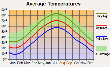
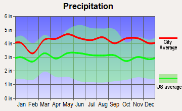
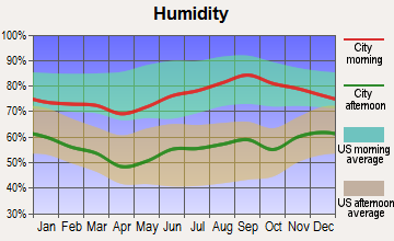
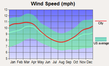
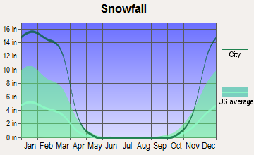
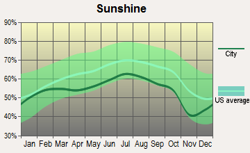
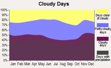
Average climate in Leyden, Massachusetts
Based on data reported by over 4,000 weather stations
(lower is better)

Air Quality Index (AQI) level in 2022 was 65.9. This is about average.
| City: | 65.9 |
| U.S.: | 72.6 |


Sulfur Dioxide (SO2) [ppb] level in 2003 was 3.66. This is significantly worse than average. Closest monitor was 5.0 miles away from the city center.
| City: | 3.66 |
| U.S.: | 1.51 |

Ozone [ppb] level in 2022 was 23.8. This is significantly better than average. Closest monitor was 6.6 miles away from the city center.
| City: | 23.8 |
| U.S.: | 33.3 |

Particulate Matter (PM2.5) [µg/m3] level in 2022 was 7.11. This is about average. Closest monitor was 6.6 miles away from the city center.
| City: | 7.11 |
| U.S.: | 8.11 |
Tornado activity:
Leyden-area historical tornado activity is slightly above Massachusetts state average. It is 17% smaller than the overall U.S. average.
On 6/9/1953, a category F4 (max. wind speeds 207-260 mph) tornado 28.1 miles away from the Leyden town center killed 90 people and injured 1228 people and caused between $50,000,000 and $500,000,000 in damages.
On 9/13/1971, a category F3 (max. wind speeds 158-206 mph) tornado 25.6 miles away from the town center caused between $5000 and $50,000 in damages.
Earthquake activity:
Leyden-area historical earthquake activity is significantly above Massachusetts state average. It is 70% smaller than the overall U.S. average.On 10/7/1983 at 10:18:46, a magnitude 5.3 (5.1 MB, 5.3 LG, 5.1 ML, Class: Moderate, Intensity: VI - VII) earthquake occurred 122.4 miles away from Leyden center
On 4/20/2002 at 10:50:47, a magnitude 5.3 (5.3 ML, Depth: 3.0 mi) earthquake occurred 136.4 miles away from the city center
On 4/20/2002 at 10:50:47, a magnitude 5.2 (5.2 MB, 4.2 MS, 5.2 MW, 5.0 MW) earthquake occurred 135.2 miles away from Leyden center
On 1/19/1982 at 00:14:42, a magnitude 4.7 (4.5 MB, 4.7 MD, 4.5 LG, Class: Light, Intensity: IV - V) earthquake occurred 75.9 miles away from Leyden center
On 10/16/2012 at 23:12:25, a magnitude 4.7 (4.7 ML, Depth: 10.0 mi) earthquake occurred 117.3 miles away from the city center
On 6/17/1991 at 08:53:16, a magnitude 4.1 (4.0 MB, 4.0 LG, Depth: 3.1 mi) earthquake occurred 104.4 miles away from Leyden center
Magnitude types: regional Lg-wave magnitude (LG), body-wave magnitude (MB), duration magnitude (MD), local magnitude (ML), surface-wave magnitude (MS), moment magnitude (MW)
Natural disasters:
The number of natural disasters in Franklin County (20) is greater than the US average (15).Major Disasters (Presidential) Declared: 9
Emergencies Declared: 10
Causes of natural disasters: Floods: 5, Storms: 5, Hurricanes: 4, Snowstorms: 4, Winter Storms: 3, Blizzards: 2, Snows: 2, Snowfall: 1, Tropical Storm: 1, Wind: 1, Other: 1 (Note: some incidents may be assigned to more than one category).
Hospitals and medical centers near Leyden:
- HOSPICE OF FRANKLIN COUNTY, INC (Hospital, about 7 miles away; GREENFIELD, MA)
- FRANKLIN CENTER (Nursing Home, about 7 miles away; GREENFIELD, MA)
- NURSE'S HOUSE CALL - GREENFIELD (Home Health Center, about 7 miles away; GREENFIELD, MA)
- YANKEE FAMILY DIALYSIS CENTER (Dialysis Facility, about 7 miles away; GREENFIELD, MA)
- POET'S SEAT HEALTH CARE CENTER (Nursing Home, about 7 miles away; GREENFIELD, MA)
- BAYSTATE FRANKLIN MEDICAL CENTER Acute Care Hospitals (about 8 miles away; GREENFIELD, MA)
- HOSPICE OF FRANKLIN COUNTY (Hospital, about 8 miles away; GREENFIELD, MA)
Operable nuclear power plant near Leyden:
- 8 miles: Vermont Yankee in Vernon, VT.
Colleges/universities with over 2000 students nearest to Leyden:
- University of Massachusetts-Amherst (about 23 miles; Amherst, MA; Full-time enrollment: 26,583)
- Keene State College (about 24 miles; Keene, NH; FT enrollment: 5,098)
- Smith College (about 27 miles; Northampton, MA; FT enrollment: 3,549)
- Williams College (about 30 miles; Williamstown, MA; FT enrollment: 2,141)
- Franklin Pierce University (about 30 miles; Rindge, NH; FT enrollment: 2,139)
- Mount Holyoke College (about 31 miles; South Hadley, MA; FT enrollment: 2,573)
- Mount Wachusett Community College (about 34 miles; Gardner, MA; FT enrollment: 3,143)
Public elementary/middle school in Leyden:
- PEARL E RHODES ELEMENTARY (Students: 59, Location: 7 BRATTLEBORO ROAD, Grades: PK-6)
Points of interest:
Notable location: Leyden Fire Department (A). Display/hide its location on the map
Church in Leyden: Leyden United Methodist Church (A). Display/hide its location on the map
Cemeteries: South Cemetery (1), West Leyden Cemetery (2), East Hill Cemetery (3), Beaver Meadow Cemetery (4). Display/hide their locations on the map
Reservoirs: Greenfield Reservoir (A), Greenfield Reservoir - Lower Glen (B). Display/hide their locations on the map
Streams, rivers, and creeks: Brandy Brook (A), East Glen Brook (B), Beaver Meadow Brook (C), Stafford Brook (D), Harris Brook (E). Display/hide their locations on the map
Birthplace of: Ralph P. Buckland - Union Army general.
| This town: | 2.5 people |
| Massachusetts: | 2.5 people |
| This town: | 75.0% |
| Whole state: | 63.0% |
| This town: | 7.6% |
| Whole state: | 7.0% |
Likely homosexual households (counted as self-reported same-sex unmarried-partner households)
- Lesbian couples: 1.0% of all households
- Gay men: 1.0% of all households
| This town: | 4.7% |
| Whole state: | 9.3% |
| This town: | 2.0% |
| Whole state: | 4.4% |
For population 15 years and over in Leyden:

- Never married: 20.5%
- Now married: 66.9%
- Separated: 2.4%
- Widowed: 3.6%
- Divorced: 6.5%
For population 25 years and over in Leyden:
- High school or higher: 91.5%
- Bachelor's degree or higher: 26.4%
- Graduate or professional degree: 10.8%
- Unemployed: 3.0%
- Mean travel time to work (commute): 25.5 minutes


| Here: | 9.2 |
| Massachusetts average: | 13.1 |


Graphs represent county-level data. Detailed 2008 Election Results
Religion statistics for Leyden, MA (based on Franklin County data)


| Religion | Adherents | Congregations |
|---|---|---|
| Catholic | 16,509 | 15 |
| Mainline Protestant | 4,617 | 38 |
| Evangelical Protestant | 2,079 | 20 |
| Other | 1,580 | 21 |
| None | 46,587 | - |
Food Environment Statistics:
| Franklin County: | 3.63 / 10,000 pop. |
| Massachusetts: | 1.98 / 10,000 pop. |
| This county: | 0.14 / 10,000 pop. |
| Massachusetts: | 0.05 / 10,000 pop. |
| This county: | 1.67 / 10,000 pop. |
| Massachusetts: | 2.22 / 10,000 pop. |
| Franklin County: | 3.21 / 10,000 pop. |
| State: | 1.77 / 10,000 pop. |
| Here: | 8.10 / 10,000 pop. |
| Massachusetts: | 8.76 / 10,000 pop. |
| Franklin County: | 7.5% |
| Massachusetts: | 8.1% |
| Here: | 22.2% |
| Massachusetts: | 22.5% |
| Franklin County: | 15.1% |
| Massachusetts: | 16.5% |
Strongest AM radio stations in Leyden:
- WIZZ (1520 AM; daytime; 10 kW; GREENFIELD, MA; Owner: P. & M. RADIO, LLC)
- WNNZ (640 AM; 50 kW; WESTFIELD, MA; Owner: CLEAR CHANNEL BROADCASTING LICENSES, INC.)
- WCRN (830 AM; 50 kW; WORCESTER, MA; Owner: CARTER BROADCASTING CORPORATION)
- WVNE (760 AM; daytime; 25 kW; LEICESTER, MA; Owner: BLOUNT MASSCOM, INC.)
- WHMQ (1240 AM; 1 kW; GREENFIELD, MA; Owner: SAGA COMMUNICATIONS OF NEW ENGLAND, LLC)
- WRKO (680 AM; 50 kW; BOSTON, MA; Owner: ENTERCOM BOSTON LICENSE, LLC)
- WGY (810 AM; 50 kW; SCHENECTADY, NY; Owner: CLEAR CHANNEL BROADCASTING LICENSES, INC.)
- WTIC (1080 AM; 50 kW; HARTFORD, CT; Owner: INFINITY RADIO OPERATIONS INC.)
- WEEI (850 AM; 50 kW; BOSTON, MA; Owner: ENTERCOM BOSTON LICENSE, LLC)
- WKOX (1200 AM; 50 kW; FRAMINGHAM, MA; Owner: CAPSTAR TX LIMITED PARTNERSHIP)
- WCAT (700 AM; daytime; 2 kW; ORANGE-ATHOL, MA; Owner: CITADEL BROADCASTING COMPANY)
- WALE (990 AM; 50 kW; GREENVILLE, RI; Owner: NORTH AMERICAN BROADCASTING CO., INC.)
- WPTR (1540 AM; 50 kW; ALBANY, NY; Owner: KIMTRON, INC.)
Strongest FM radio stations in Leyden:
- WPVQ (95.3 FM; GREENFIELD, MA; Owner: GREAT NORTHERN RADIO, L.L.C.)
- WHAI (98.3 FM; GREENFIELD, MA; Owner: SAGA COMMUNICATIONS OF NEW ENGLAND, LLC)
- WRSY (101.5 FM; MARLBORO, VT; Owner: GREAT NORTHERN RADIO, L.L.C.)
- WYRY (104.9 FM; HINSDALE, NH; Owner: TRI-VALLEY BROADCASTING CORPORATION)
- WAMC-FM (90.3 FM; ALBANY, NY; Owner: WAMC)
- WVAY (100.7 FM; WILMINGTON, VT; Owner: GREAT NORTHERN RADIO, L.L.C.)
- WRSI (93.9 FM; TURNERS FALLS, MA; Owner: GREAT NORTHERN RADIO, LLC)
- WKVT-FM (92.7 FM; BRATTLEBORO, VT; Owner: SAGA COMMUNICATIONS OF NEW ENGLAND, LLC)
- WEQX (102.7 FM; MANCHESTER, VT; Owner: NORTHSHIRE COMMUNICATIONS, INC.)
- WJAN (95.1 FM; SUNDERLAND, VT; Owner: 6 JOHNSON ROAD LICENSES, INC.)
- WOQL (98.7 FM; WINCHESTER, NH; Owner: SAGA COMMUNICATIONS OF NEW HAMPSHIRE, LLC)
- WCMK (91.9 FM; PUTNEY, VT; Owner: CHRISTIAN MINISTRIES INC)
- WFCR (88.5 FM; AMHERST, MA; Owner: UNIVERSITY OF MASSACHUSETTS)
- WKNE (103.7 FM; KEENE, NH; Owner: SAGA COMMUNICATIONS OF NEW ENGLAND, LLC)
- WGAJ (91.7 FM; DEERFIELD, MA; Owner: TRUATEES OF DEERFIELD ACADEMY)
- WHDQ (106.1 FM; CLAREMONT, NH; Owner: GREAT NORTHERN RADIO, L.L.C.)
- WEVN (90.7 FM; KEENE, NH; Owner: NEW HAMPSHIRE PUBLIC RADIO, INC.)
- WVPR (89.5 FM; WINDSOR, VT; Owner: VERMONT PUBLIC RADIO)
- WFEX (92.1 FM; PETERBOROUGH, NH; Owner: FNX BROADCASTING OF NEW HAMPSHIRE LLC)
- WJJR (98.1 FM; RUTLAND, VT; Owner: 6 JOHNSON ROAD LICENSES, INC.)
TV broadcast stations around Leyden:
- WYDN (Channel 48; WORCESTER, MA; Owner: EDUCATIONAL PUBLIC TV CORPORATION)
- WEKW-TV (Channel 52; KEENE, NH; Owner: UNIVERSITY OF NEW HAMPSHIRE)
- W35BK (Channel 35; PLAINFIELD, MA; Owner: LYDIA SYLVANE STOCKWELL)
- National Bridge Inventory (NBI) Statistics
- 1Number of bridges
- 3ft / 0.6mTotal length
- $344,000Total costs
- 259Total average daily traffic
- 15Total average daily truck traffic
- 409Total future (year 2032) average daily traffic
FCC Registered Antenna Towers:
4- Wayne S Reese, Frizzell Rd (Lat: 42.697222 Lon: -72.605000), Type: 86.0, Overall height: 85 m, Registrant: Saga Communications Of New England, LLC, Gurbiel@sagacom.Com, , Gross-e Pointe Farms, Phone: (313) 886-7070
- Justin W Asher, 0.65 Km North Of The "t" Intersection Of Frizzell Hill Road And East Hill Road (Lat: 42.698028 Lon: -72.605139), Type: 86.0, Structure height: 25011 m, Overall height: 85 m, Licensee ID: L, Registrant: Saga Communications Of New England, LLC, Fcclicenses@sagacom.Com, , Gross-e Pointe Farms, Phone: (313) 886-7070
- Justin W Asher, 0.65 Km North Of The "t" Intersection Of Frizzell Hill Road And East Hill Road (Lat: 42.698028 Lon: -72.605139), Type: 86.0, Structure height: 25011 m, Overall height: 85 m, Registrant: Saga Communications Of New England, LLC, Fcclicenses@sagacom.Com, , Gross-e Pointe Farms, Phone: (313) 886-7070
- Frizzell Rd (Lat: 42.697222 Lon: -72.605000), Type: 86.0, Overall height: 85 m, Registrant: Watertown Radio Associates LP, 1230 Clare-mont, Phone: (603) 542-7735
FCC Registered Microwave Towers:
1- LEYDEN, Frizzell Rd (Lat: 42.697222 Lon: -72.605000), Type: Tower, Structure height: 85 m, Overall height: 86 m, Call Sign: WQEE633,
Assigned Frequencies: 10658.7 MHz, Grant Date: 10/14/2015, Expiration Date: 01/09/2026, Certifier: Linda Dunlavy, Registrant: Franklin Regional Council Of Governments, 12 Olive St Ste 2, Greenfield, MA 01301-3351, Phone: (413) 774-3167, Fax: (413) 774-3169, Email:
FCC Registered Amateur Radio Licenses:
3- Call Sign: N1AW, Licensee ID: L00290673, Grant Date: 08/18/2022, Expiration Date: 09/01/2032, Certifier: Albert S Woodhull, Registrant: Albert S Woodhull, 199 Eden Trail Rd, Leyden, MA 01337
- Call Sign: N1WYU, Licensee ID: L00237817, Grant Date: 04/13/2006, Expiration Date: 04/03/2016, Cancellation Date: 04/04/2018, Certifier: Dennis C Rolstad, Registrant: Dennis C Rolstad, 0202 W Leyden Rd, Leyden, MA 01337
- Call Sign: W1AMD, Previous Call Sign: KB1OKB, Licensee ID: L01238488, Grant Date: 01/25/2018, Expiration Date: 03/14/2028, Certifier: Aaron M Dulles, Registrant: Aaron M Dulles, 756 Greenfield Rd., Leyden, MA 01301
2002 - 2018 National Fire Incident Reporting System (NFIRS) incidents
- Fire incident types reported to NFIRS in Leyden, MA
- 8070.8%Structure Fires
- 2623.0%Outside Fires
- 76.2%Mobile Property/Vehicle Fires
 Based on the data from the years 2002 - 2018 the average number of fires per year is 7. The highest number of fire incidents - 16 took place in 2004, and the least - 2 in 2008. The data has a growing trend.
 When looking into fire subcategories, the most reports belonged to: Structure Fires (70.8%), and Outside Fires (23.0%).
- 43.1%Fuel oil, kerosene, etc.
- 37.9%Wood
- 8.5%Bottled, tank, or LP gas
- 7.7%Electricity
- 1.6%Other fuel
- 1.2%Utility gas

- 48.1%Fuel oil, kerosene, etc.
- 25.9%Bottled, tank, or LP gas
- 18.5%Electricity
- 7.4%Wood
Leyden compared to Massachusetts state average:
- Unemployed percentage significantly below state average.
- Black race population percentage significantly below state average.
- Hispanic race population percentage significantly below state average.
- Median age significantly above state average.
- Foreign-born population percentage significantly below state average.
- Renting percentage significantly below state average.
- Length of stay since moving in significantly above state average.
- Number of rooms per house significantly below state average.
- House age significantly below state average.
- Number of college students below state average.

|
Total of 6 patent applications in 2008-2024.