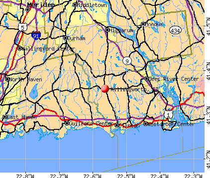
Killingworth, Connecticut

Submit your own pictures of this town and show them to the world
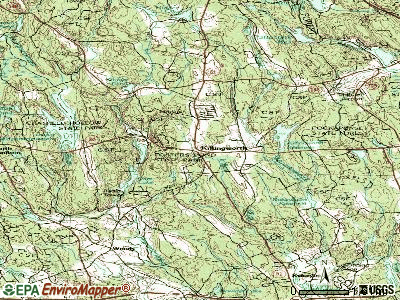
- OSM Map
- General Map
- Google Map
- MSN Map
Population change since 2000: +8.4%
 |
| Males: 3,216 | |
| Females: 3,309 |
| Median resident age: | 46.5 years |
| Connecticut median age: | 39.2 years |
Zip codes: 06419.
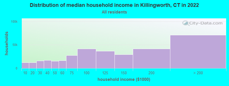
| Killingworth: | $132,484 |
| CT: | $88,429 |
Estimated per capita income in 2022: $57,253 (it was $31,929 in 2000)
Killingworth town income, earnings, and wages data
Estimated median house or condo value in 2022: $498,316 (it was $230,500 in 2000)
| Killingworth: | $498,316 |
| CT: | $347,200 |
Mean prices in 2022: all housing units: $381,367; detached houses: $403,130; townhouses or other attached units: $256,262; in 2-unit structures: $274,238; in 3-to-4-unit structures: $246,924; in 5-or-more-unit structures: $191,256; mobile homes: $82,291
Detailed information about poverty and poor residents in Killingworth, CT
Compare current foreclosures near Killingworth, CT:
| Photo | Address | Area | Beds / Baths | Price | Details |
|---|---|---|---|---|---|

|
#1
Kelseytown Rd
Killingworth, CT 06419
|
1,505 sq. feet
|
2 baths 4 beds |
show details | |

|
#2
Strong St
New Haven, CT 06512
|
1,122 sq. feet
|
1 baths 3 beds |
$171,600
|
show details |

|
#3
Royal Oak Lane
Wallingford, CT 06492
|
2,607 sq. feet
|
2 baths 4 beds |
$684,900
|
show details |

|
#4
Westchester Rd
Colchester, CT 06415
|
900 sq. feet
|
1 baths 2 beds |
$309,900
|
show details |

|
#5
Beechwood Rd
Branford, CT 06405
|
2,204 sq. feet
|
2 baths 4 beds |
$723,500
|
show details |

|
#6
Willis Ave
Meriden, CT 06450
|
1,008 sq. feet
|
1 baths 2 beds |
$299,900
|
show details |

|
#7
Stonegate Cir #2e
Branford, CT 06405
|
1,538 sq. feet
|
1 baths 2 beds |
$319,000
|
show details |

|
#8
Branford Rd Unit 150
North Branford, CT 06471
|
851 sq. feet
|
1 baths 2 beds |
$234,900
|
show details |

|
#9
Railroad Ave
Chester, CT 06412
|
2,092 sq. feet
|
2 baths 4 beds |
$484,900
|
show details |

|
#10
Route 80
Killingworth, CT 06419
|
- sq. feet
|
- baths - beds |
show details |
| Photo | Address | Area | Beds / Baths | Price | Details |
|---|---|---|---|---|---|

|
#11
Windsor Rd
Hamden, CT 06517
|
1,116 sq. feet
|
3 baths 4 beds |
show details | |

|
#12
Orient St
Meriden, CT 06450
|
1,780 sq. feet
|
3 baths 3 beds |
show details | |

|
#13
Amity St
Meriden, CT 06450
|
1,568 sq. feet
|
2 baths 3 beds |
show details | |

|
#14
Evansville Ave
Meriden, CT 06451
|
624 sq. feet
|
1 baths 3 beds |
show details | |

|
#15
Lydale Pl
Meriden, CT 06450
|
1,716 sq. feet
|
2 baths 3 beds |
show details | |

|
#16
Feather Ln
North Branford, CT 06471
|
4,408 sq. feet
|
2 baths 4 beds |
show details | |

|
#17
Plymouth Colony
Branford, CT 06405
|
1,390 sq. feet
|
1 baths 2 beds |
show details | |

|
#18
Old Acres Rd
Moodus, CT 06469
|
1,298 sq. feet
|
2 baths 3 beds |
show details | |

|
#19
E Main St
Middletown, CT 06457
|
1,736 sq. feet
|
2 baths 3 beds |
show details | |

|
#20
Avery Ave
Meriden, CT 06450
|
1,508 sq. feet
|
1 baths 3 beds |
show details |
| Photo | Address | Area | Beds / Baths | Price | Details |
|---|---|---|---|---|---|

|
#21
Dora Dr
New Haven, CT 06513
|
1,302 sq. feet
|
1 baths 3 beds |
show details | |

|
#22
Borrmann Rd
East Haven, CT 06512
|
1,222 sq. feet
|
2 baths 4 beds |
show details | |

|
#23
Mohawk Dr
Wallingford, CT 06492
|
1,524 sq. feet
|
3 baths 4 beds |
show details | |

|
#24
Mount Parnassus Rd
East Haddam, CT 06423
|
2,328 sq. feet
|
3 baths 3 beds |
show details | |

|
#25
Reskin Dr
Wallingford, CT 06492
|
2,303 sq. feet
|
1 baths 4 beds |
show details | |

|
#26
Foxon Rd
North Branford, CT 06471
|
1,687 sq. feet
|
1 baths 2 beds |
show details | |

|
#27
Spring St
Meriden, CT 06451
|
660 sq. feet
|
1 baths 3 beds |
show details | |

|
#28
Cartpath Dr
Meriden, CT 06450
|
804 sq. feet
|
1 baths 2 beds |
show details | |

|
#29
Pratt St
Meriden, CT 06450
|
1,040 sq. feet
|
2 baths 3 beds |
show details | |

|
#30
Obrien Dr
Meriden, CT 06450
|
1,612 sq. feet
|
2 baths 2 beds |
show details |
| Photo | Address | Area | Beds / Baths | Price | Details |
|---|---|---|---|---|---|

|
#31
Brainerd Dr
Portland, CT 06480
|
1,248 sq. feet
|
2 baths 3 beds |
show details | |

|
#32
Liberty St
Meriden, CT 06450
|
924 sq. feet
|
2 baths 2 beds |
show details | |

|
#33
Lydale Pl
Meriden, CT 06450
|
1,572 sq. feet
|
2 baths 3 beds |
show details | |

|
#34
Quinnipiac Ave
North Haven, CT 06473
|
1,904 sq. feet
|
2 baths 3 beds |
show details | |

|
#35
Brentwood Dr
Wallingford, CT 06492
|
1,024 sq. feet
|
1 baths 2 beds |
show details | |

|
#36
Charlton Hill Rd
Hamden, CT 06518
|
1,362 sq. feet
|
2 baths 2 beds |
show details | |

|
#37
Brentwood Dr
Wallingford, CT 06492
|
1,217 sq. feet
|
1 baths 2 beds |
show details | |

|
#38
Mansion Rd
Wallingford, CT 06492
|
2,068 sq. feet
|
2 baths 5 beds |
show details | |

|
#39
Sundance Dr
Branford, CT 06405
|
1,259 sq. feet
|
1 baths 2 beds |
show details | |

|
#40
Koczak Ct
North Haven, CT 06473
|
1,320 sq. feet
|
1 baths 3 beds |
show details |
| Photo | Address | Area | Beds / Baths | Price | Details |
|---|---|---|---|---|---|

|
#41
Hanover St
Wallingford, CT 06492
|
1,899 sq. feet
|
2 baths 4 beds |
show details | |

|
#42
N High St
East Haven, CT 06512
|
1,819 sq. feet
|
2 baths 3 beds |
show details | |

|
#43
Farm Gate Rd
Colchester, CT 06415
|
3,622 sq. feet
|
3 baths 3 beds |
show details | |

|
#44
Willow Rd
New Haven, CT 06512
|
1,582 sq. feet
|
1 baths 5 beds |
show details | |

|
#45
East St
Middletown, CT 06457
|
1,598 sq. feet
|
1 baths 3 beds |
show details | |

|
#46
Salem Dr
Cromwell, CT 06416
|
1,218 sq. feet
|
2 baths 2 beds |
show details | |

|
#47
Crest Ave
New Haven, CT 06513
|
1,248 sq. feet
|
1 baths 2 beds |
show details | |

|
#48
S Dale St
New Haven, CT 06513
|
1,868 sq. feet
|
2 baths 2 beds |
show details | |

|
#49
Curtis St
Meriden, CT 06450
|
1,786 sq. feet
|
1 baths 3 beds |
show details | |

|
Check over 1 million property listings on Foreclosure.com!
|
browse all offers | |||

- 6,16794.5%White alone
- 1412.2%Hispanic
- 791.2%Two or more races
- 741.1%Asian alone
- 460.7%Black alone
- 130.2%American Indian alone
- 30.05%Native Hawaiian and Other
Pacific Islander alone - 20.03%Other race alone
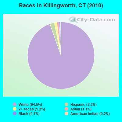
Races in Killingworth detailed stats: ancestries, foreign born residents, place of birth
According to our research of Connecticut and other state lists, there was 1 registered sex offender living in Killingworth, Connecticut as of May 08, 2024.
The ratio of all residents to sex offenders in Killingworth is 6,525 to 1.
The ratio of registered sex offenders to all residents in this city is much lower than the state average.
 Recent articles from our blog. Our writers, many of them Ph.D. graduates or candidates, create easy-to-read articles on a wide variety of topics.


 | 2024 Connecticut Town Tournament VI (Celebrating the 10-Year Anniversary & Dazzleman's Memorial) (830 replies) |
| Connecticut Weather Discussion 3 (8061 replies) |
| Connecticut TOWN TOURNAMENT V (2022) (831 replies) |
| Cell reception in Killingworth, CT? (2 replies) |
| non-resident beach passes (30 replies) |
| Recommendations for small(ish) towns that might come close to this? (33 replies) |
Latest news from Killingworth, CT collected exclusively by city-data.com from local newspapers, TV, and radio stations
Killingworth, CT City Guides:
Ancestries: Italian (23.2%), Irish (21.9%), English (21.1%), German (19.2%), Polish (9.7%), French (6.6%).
Current Local Time: EST time zone
Incorporated on 05/1667
Elevation: 374 feet
Land area: 35.3 square miles.
Population density: 185 people per square mile (very low).
204 residents are foreign born (1.4% Europe, 1.0% North America, 0.7% Latin America).
| This town: | 3.4% |
| Connecticut: | 10.9% |
| Killingworth town: | 1.6% ($3,602) |
| Connecticut: | 1.8% ($2,961) |
Nearest city with pop. 50,000+: Meriden, CT  (15.7 miles , pop. 58,244).
Nearest city with pop. 200,000+: North Hempstead, NY (70.5 miles , pop. 222,611).
Nearest city with pop. 1,000,000+: Bronx, NY (77.0 miles , pop. 1,332,650).
Nearest cities:
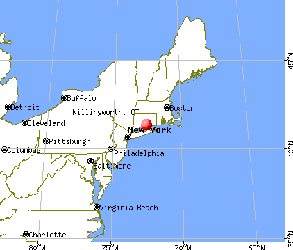
), ), ), Latitude: 41.38 N, Longitude: 72.58 W
Area code: 860

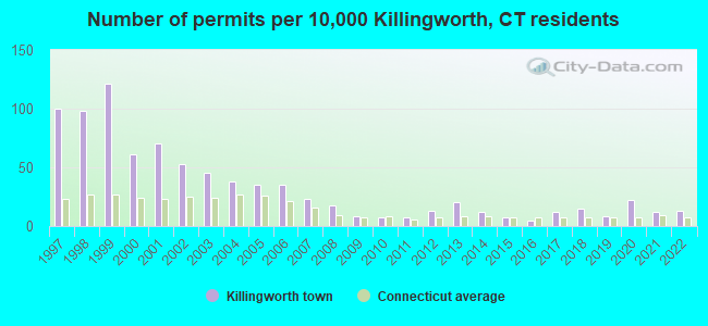
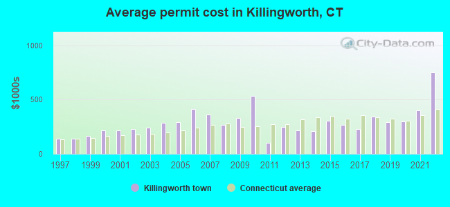
Single-family new house construction building permits:
- 2022: 8 buildings, average cost: $750,900
- 2021: 7 buildings, average cost: $403,200
- 2020: 13 buildings, average cost: $298,300
- 2019: 5 buildings, average cost: $289,700
- 2018: 9 buildings, average cost: $341,100
- 2017: 7 buildings, average cost: $229,700
- 2016: 3 buildings, average cost: $268,000
- 2015: 4 buildings, average cost: $306,100
- 2014: 7 buildings, average cost: $206,500
- 2013: 12 buildings, average cost: $219,300
- 2012: 8 buildings, average cost: $246,900
- 2011: 4 buildings, average cost: $103,600
- 2010: 4 buildings, average cost: $534,300
- 2009: 5 buildings, average cost: $331,300
- 2008: 11 buildings, average cost: $267,900
- 2007: 14 buildings, average cost: $361,400
- 2006: 21 buildings, average cost: $411,100
- 2005: 21 buildings, average cost: $294,800
- 2004: 23 buildings, average cost: $283,000
- 2003: 27 buildings, average cost: $238,800
- 2002: 32 buildings, average cost: $226,300
- 2001: 42 buildings, average cost: $216,300
- 2000: 37 buildings, average cost: $213,900
- 1999: 73 buildings, average cost: $166,600
- 1998: 59 buildings, average cost: $140,800
- 1997: 60 buildings, average cost: $140,800
| Here: | 2.4% |
| Connecticut: | 3.9% |
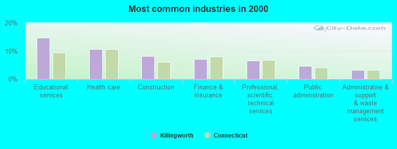
- Educational services (14.7%)
- Health care (10.6%)
- Construction (8.2%)
- Finance & insurance (7.1%)
- Professional, scientific, technical services (6.6%)
- Public administration (4.6%)
- Administrative & support & waste management services (3.3%)
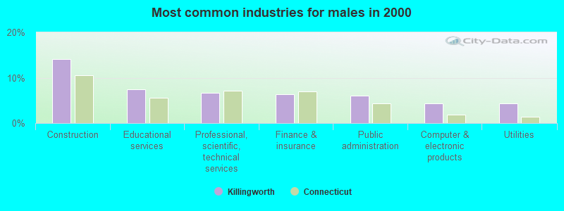
- Construction (14.1%)
- Educational services (7.4%)
- Professional, scientific, technical services (6.6%)
- Finance & insurance (6.3%)
- Public administration (6.0%)
- Computer & electronic products (4.4%)
- Utilities (4.4%)
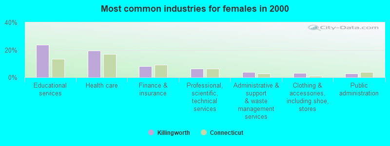
- Educational services (23.6%)
- Health care (19.6%)
- Finance & insurance (8.0%)
- Professional, scientific, technical services (6.5%)
- Administrative & support & waste management services (3.9%)
- Clothing & accessories, including shoe, stores (3.3%)
- Public administration (2.8%)
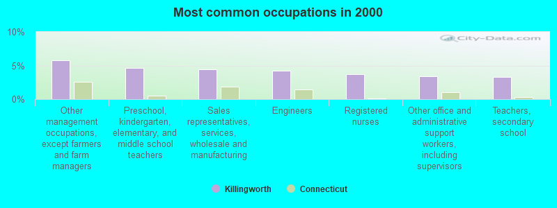
- Other management occupations, except farmers and farm managers (5.7%)
- Preschool, kindergarten, elementary, and middle school teachers (4.7%)
- Sales representatives, services, wholesale and manufacturing (4.4%)
- Engineers (4.2%)
- Registered nurses (3.7%)
- Other office and administrative support workers, including supervisors (3.4%)
- Teachers, secondary school (3.3%)
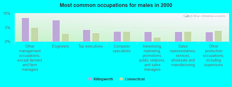
- Other management occupations, except farmers and farm managers (8.4%)
- Engineers (7.6%)
- Top executives (4.2%)
- Computer specialists (3.6%)
- Advertising, marketing, promotions, public relations, and sales managers (3.5%)
- Sales representatives, services, wholesale and manufacturing (3.5%)
- Other production occupations, including supervisors (3.4%)

- Preschool, kindergarten, elementary, and middle school teachers (8.9%)
- Registered nurses (7.6%)
- Other office and administrative support workers, including supervisors (5.9%)
- Sales representatives, services, wholesale and manufacturing (5.5%)
- Secretaries and administrative assistants (4.3%)
- Teachers, secondary school (4.0%)
- Retail sales workers, except cashiers (3.5%)
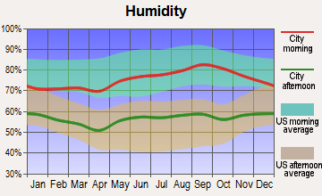
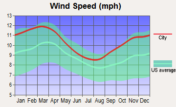
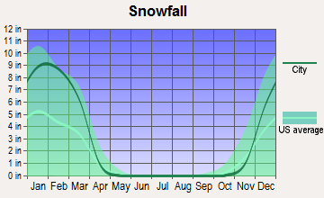
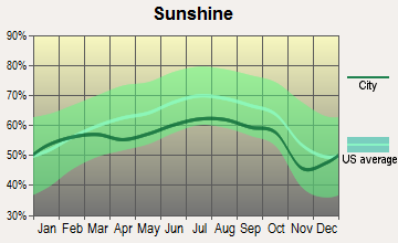
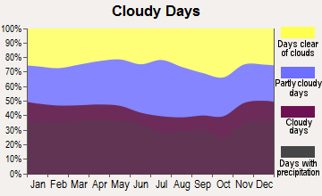
Average climate in Killingworth, Connecticut
Based on data reported by over 4,000 weather stations
(lower is better)
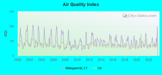
Air Quality Index (AQI) level in 2022 was 80.9. This is about average.
| City: | 80.9 |
| U.S.: | 72.6 |
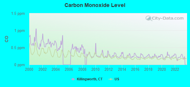
Carbon Monoxide (CO) [ppm] level in 2022 was 0.223. This is about average. Closest monitor was 17.8 miles away from the city center.
| City: | 0.223 |
| U.S.: | 0.251 |
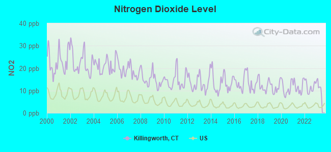
Nitrogen Dioxide (NO2) [ppb] level in 2022 was 11.6. This is significantly worse than average. Closest monitor was 8.4 miles away from the city center.
| City: | 11.6 |
| U.S.: | 5.1 |
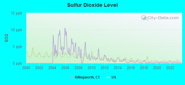
Sulfur Dioxide (SO2) [ppb] level in 2022 was 0.214. This is significantly better than average. Closest monitor was 12.2 miles away from the city center.
| City: | 0.214 |
| U.S.: | 1.515 |
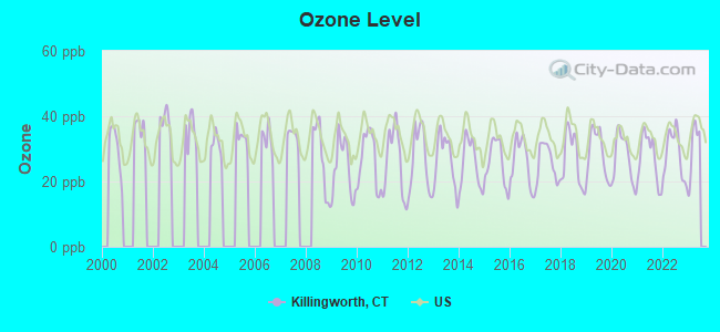
Ozone [ppb] level in 2022 was 28.4. This is about average. Closest monitor was 6.8 miles away from the city center.
| City: | 28.4 |
| U.S.: | 33.3 |
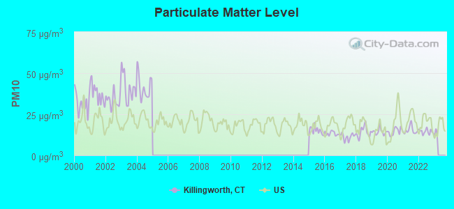
Particulate Matter (PM10) [µg/m3] level in 2022 was 14.5. This is better than average. Closest monitor was 7.4 miles away from the city center.
| City: | 14.5 |
| U.S.: | 19.2 |
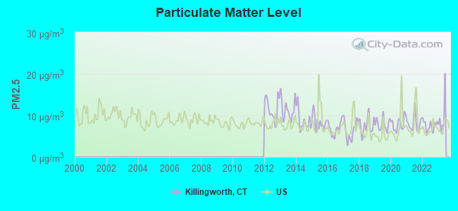
Particulate Matter (PM2.5) [µg/m3] level in 2022 was 7.51. This is about average. Closest monitor was 17.6 miles away from the city center.
| City: | 7.51 |
| U.S.: | 8.11 |
Tornado activity:
Killingworth-area historical tornado activity is slightly below Connecticut state average. It is 40% smaller than the overall U.S. average.
On 7/10/1989, a category F4 (max. wind speeds 207-260 mph) tornado 16.8 miles away from the Killingworth town center injured 40 people and caused between $50,000,000 and $500,000,000 in damages.
On 10/3/1979, a category F4 tornado 34.9 miles away from the town center killed 3 people and injured 500 people and caused between $50,000,000 and $500,000,000 in damages.
Earthquake activity:
Killingworth-area historical earthquake activity is significantly above Connecticut state average. It is 71% smaller than the overall U.S. average.On 10/7/1983 at 10:18:46, a magnitude 5.3 (5.1 MB, 5.3 LG, 5.1 ML, Class: Moderate, Intensity: VI - VII) earthquake occurred 199.3 miles away from the city center
On 4/20/2002 at 10:50:47, a magnitude 5.3 (5.3 ML, Depth: 3.0 mi) earthquake occurred 223.9 miles away from the city center
On 4/20/2002 at 10:50:47, a magnitude 5.2 (5.2 MB, 4.2 MS, 5.2 MW, 5.0 MW) earthquake occurred 222.5 miles away from the city center
On 1/19/1982 at 00:14:42, a magnitude 4.7 (4.5 MB, 4.7 MD, 4.5 LG, Class: Light, Intensity: IV - V) earthquake occurred 154.8 miles away from the city center
On 8/23/2011 at 17:51:04, a magnitude 5.8 (5.8 MW, Depth: 3.7 mi) earthquake occurred 372.9 miles away from the city center
On 8/22/1992 at 12:20:32, a magnitude 4.8 (4.8 MB, 3.8 MS, 4.7 LG, Depth: 6.2 mi) earthquake occurred 197.4 miles away from Killingworth center
Magnitude types: regional Lg-wave magnitude (LG), body-wave magnitude (MB), duration magnitude (MD), local magnitude (ML), surface-wave magnitude (MS), moment magnitude (MW)
Natural disasters:
The number of natural disasters in Middlesex County (21) is greater than the US average (15).Major Disasters (Presidential) Declared: 12
Emergencies Declared: 9
Causes of natural disasters: Hurricanes: 6, Storms: 6, Floods: 5, Blizzards: 3, Snowstorms: 3, Winter Storms: 3, Snow: 1, Snowfall: 1, Tropical Storm: 1, Wind: 1 (Note: some incidents may be assigned to more than one category).
Hospitals and medical centers near Killingworth:
- AARON MANOR NURSING AND REHABILITATION (Nursing Home, about 6 miles away; CHESTER, CT)
- CHESTERFIELDS HEALTH CARE CENTER (Nursing Home, about 7 miles away; CHESTER, CT)
- MADISON HOUSE REHABILITATION AND NURSING CENTER (Nursing Home, about 8 miles away; MADISON, CT)
- APPLE REHAB GUILFORD (Nursing Home, about 8 miles away; GUILFORD, CT)
- WATROUS NURSING CENTER (Nursing Home, about 8 miles away; MADISON, CT)
- SHORELINE SURGERY CENTER, LLC (Hospital, about 8 miles away; GUILFORD, CT)
- CLINTON HEALTH CARE CENTER (Nursing Home, about 8 miles away; CLINTON, CT)
Amtrak stations near Killingworth:
- 12 miles: OLD SAYBROOK (455 BOSTON POST RD.) . Services: ticket office, partially wheelchair accessible, enclosed waiting area, public restrooms, public payphones, free short-term parking, free long-term parking, call for car rental service, call for taxi service, public transit connection.
- 14 miles: WALLINGFORD (37 HALL AVE.) . Services: partially wheelchair accessible, enclosed waiting area, public payphones, free short-term parking, call for car rental service, call for taxi service.
- 16 miles: MERIDEN (60 STATE ST.) . Services: ticket office, partially wheelchair accessible, enclosed waiting area, public restrooms, public payphones, vending machines, call for car rental service, call for taxi service, public transit connection.
Colleges/universities with over 2000 students nearest to Killingworth:
- Wesleyan University (about 13 miles; Middletown, CT; Full-time enrollment: 3,517)
- Quinnipiac University (about 17 miles; Hamden, CT; FT enrollment: 8,153)
- Yale University (about 19 miles; New Haven, CT; FT enrollment: 13,121)
- Gateway Community College (about 19 miles; New Haven, CT; FT enrollment: 4,672)
- Southern Connecticut State University (about 20 miles; New Haven, CT; FT enrollment: 8,708)
- University of New Haven (about 21 miles; West Haven, CT; FT enrollment: 6,205)
- Central Connecticut State University (about 24 miles; New Britain, CT; FT enrollment: 9,989)
Public elementary/middle school in Killingworth:
- KILLINGWORTH ELEMENTARY SCHOOL (Students: 638, Location: 380 ROUTE 81, Grades: KG-4)
Points of interest:
Notable locations in Killingworth: Deer Lake Camp (A), Killingworth Volunteer Fire Company Station 2 (B), Killingworth Volunteer Fire Company Station 1 Headquarters (C), Killingworth Ambulance Association (D). Display/hide their locations on the map
Churches in Killingworth include: Killingworth Congregational Church (A), Emmanuel Church (B). Display/hide their locations on the map
Cemeteries: Parker Hill Cemetery (1), Pine Orchard Cemetery (2), Lane District Cemetery (3), Evergreen Cemetery (4), Emmanuel Cemetery (5), Southwest Cemetery (6), Stone House Cemetery (7). Display/hide their locations on the map
Lakes, reservoirs, and swamps: Tetram Pond (A), Kroopa Pond (B), Schreeder Pond (C), Murray Ponds (D), Old Mill Pond (E), Killingworth Reservoir (F), Murray Pond Number 2 (G), Fricks Pond (H). Display/hide their locations on the map
Streams, rivers, and creeks: Pond Brook (A), Pond Meadow Brook (B), Bunker Hill Brook (C), Chatfield Hollow Brook (D), Heft Brook (E). Display/hide their locations on the map
Park in Killingworth: Chatfield Hollow State Park (1). Display/hide its location on the map
Tourist attraction: Platt Nature Center (Nature Centers; Roast Meat Hill Road) (1). Display/hide its approximate location on the map
Hotel: Century Resources (206 Route 80) (1). Display/hide its approximate location on the map
Birthplace of: Titus Coan - Christian missionary.
Drinking water stations with addresses in Killingworth and their reported violations in the past:
RIDGEWOOD HILLS ASSOCIATION, SYSTEM #1 (Population served: 72, Groundwater):Past monitoring violations:
- Follow-up Or Routine LCR Tap M/R - In JAN-10-2005, Contaminant: Lead and Copper Rule. Follow-up actions: St Compliance achieved (JUN-09-2005)
- Initial, Follow-up, or Routine Source Water M/R - In JAN-01-1994, Contaminant: Lead and Copper Rule
- 2 routine major monitoring violations
- 21 regular monitoring violations
| This town: | 2.6 people |
| Connecticut: | 2.5 people |
| This town: | 77.3% |
| Whole state: | 66.3% |
| This town: | 5.7% |
| Whole state: | 6.6% |
Likely homosexual households (counted as self-reported same-sex unmarried-partner households)
- Lesbian couples: 0.4% of all households
- Gay men: 0.5% of all households
| This town: | 0.7% |
| Whole state: | 7.9% |
| This town: | 0.3% |
| Whole state: | 3.9% |
Banks with branches in Killingworth (2011 data):
- TD Bank, National Association: Killingworth Branch at 184 Route 81, branch established on 1977/12/10. Info updated 2010/10/04: Bank assets: $188,912.6 mil, Deposits: $153,149.8 mil, headquarters in Wilmington, DE, positive income, 1314 total offices, Holding Company: Toronto-Dominion Bank, The
For population 15 years and over in Killingworth:
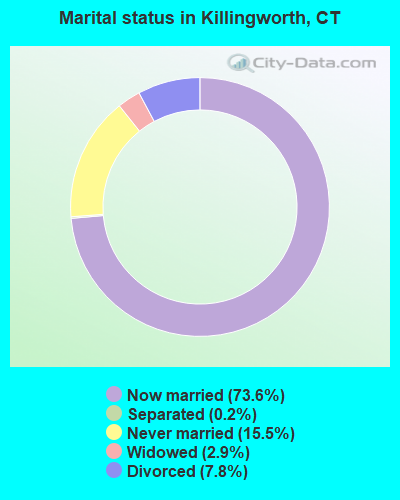
- Never married: 15.5%
- Now married: 73.6%
- Separated: 0.2%
- Widowed: 2.9%
- Divorced: 7.8%
For population 25 years and over in Killingworth:
- High school or higher: 92.8%
- Bachelor's degree or higher: 48.5%
- Graduate or professional degree: 22.5%
- Unemployed: 3.0%
- Mean travel time to work (commute): 31.8 minutes

| Here: | 10.1 |
| Connecticut average: | 12.8 |
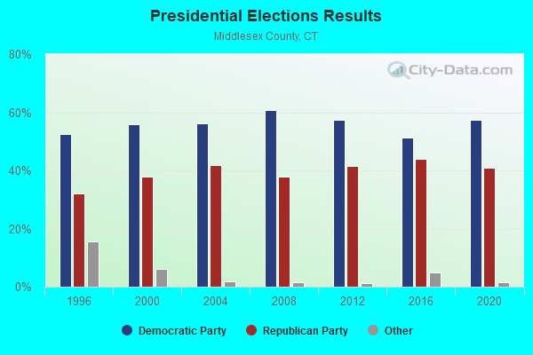
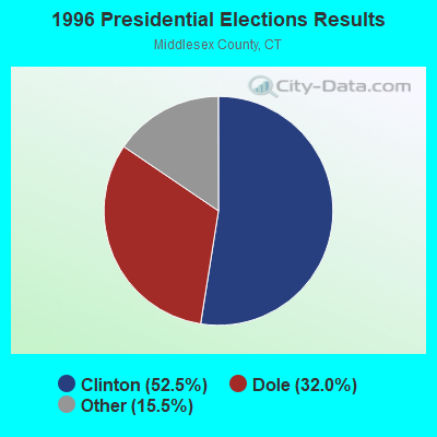
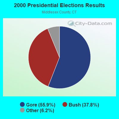
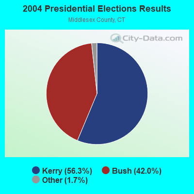
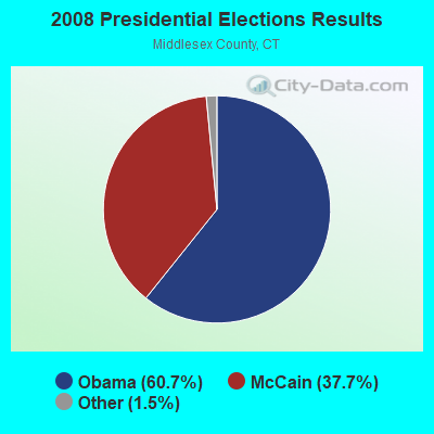
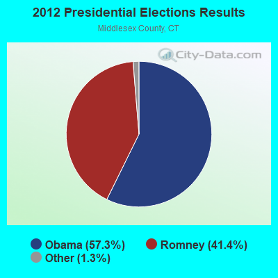
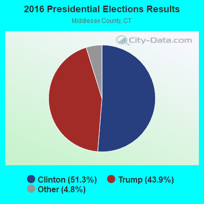

Graphs represent county-level data. Detailed 2008 Election Results
Religion statistics for Killingworth, CT (based on Middlesex County data)
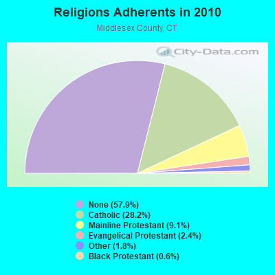
| Religion | Adherents | Congregations |
|---|---|---|
| Catholic | 46,800 | 18 |
| Mainline Protestant | 15,015 | 56 |
| Evangelical Protestant | 3,978 | 29 |
| Other | 2,921 | 11 |
| Black Protestant | 974 | 5 |
| Orthodox | 85 | 1 |
| None | 95,903 | - |
Food Environment Statistics:
| Here: | 1.71 / 10,000 pop. |
| State: | 2.21 / 10,000 pop. |
| This county: | 0.98 / 10,000 pop. |
| State: | 1.02 / 10,000 pop. |
| Middlesex County: | 2.56 / 10,000 pop. |
| Connecticut: | 2.27 / 10,000 pop. |
| Middlesex County: | 10.80 / 10,000 pop. |
| Connecticut: | 9.19 / 10,000 pop. |
| Here: | 7.0% |
| Connecticut: | 7.3% |
| Middlesex County: | 21.1% |
| State: | 21.5% |
| This county: | 13.6% |
| State: | 15.8% |
| Businesses in Killingworth, CT | ||||
| Name | Count | Name | Count | |
|---|---|---|---|---|
| Baskin-Robbins | 1 | FedEx | 1 | |
| Curves | 1 | Subway | 1 | |
| Dunkin Donuts | 1 | True Value | 1 | |
Strongest AM radio stations in Killingworth:
- WTIC (1080 AM; 50 kW; HARTFORD, CT; Owner: INFINITY RADIO OPERATIONS INC.)
- WLIS (1420 AM; 5 kW; OLD SAYBROOK, CT; Owner: CROSSROADS COMM. OLD SAYBROOK, LLC)
- WNNZ (640 AM; 50 kW; WESTFIELD, MA; Owner: CLEAR CHANNEL BROADCASTING LICENSES, INC.)
- WELI (960 AM; 5 kW; NEW HAVEN, CT; Owner: CLEAR CHANNEL BROADCASTING LICENSES, INC.)
- WMRD (1150 AM; 2 kW; MIDDLETOWN, CT; Owner: CROSSROADS COMMUNICATIONS, INC.)
- WFAN (660 AM; 50 kW; NEW YORK, NY; Owner: INFINITY BROADCASTING OPERATIONS, INC.)
- WCRN (830 AM; 50 kW; WORCESTER, MA; Owner: CARTER BROADCASTING CORPORATION)
- WALE (990 AM; 50 kW; GREENVILLE, RI; Owner: NORTH AMERICAN BROADCASTING CO., INC.)
- WCBS (880 AM; 50 kW; NEW YORK, NY; Owner: INFINITY BROADCASTING OPERATIONS, INC.)
- WMCA (570 AM; 50 kW; NEW YORK, NY; Owner: SALEM MEDIA OF NEW YORK, LLC)
- WGSM (740 AM; 25 kW; HUNTINGTON, NY; Owner: K RADIO LICENSEE, INC.)
- WABC (770 AM; 50 kW; NEW YORK, NY; Owner: WABC-AM RADIO, INC.)
- WOR (710 AM; 50 kW; NEW YORK, NY; Owner: BUCKLEY BROADCASTING CORPORATION)
Strongest FM radio stations in Killingworth:
- W227AJ (93.3 FM; NORTHFORD, CT; Owner: SACRED HEART UNIVERSITY)
- WKCI-FM (101.3 FM; HAMDEN, CT; Owner: CLEAR CHANNEL BROADCASTING LICENSES, INC.)
- WPLR (99.1 FM; NEW HAVEN, CT; Owner: COX RADIO, INC.)
- WKSS (95.7 FM; HARTFORD-MERIDEN, CT; Owner: CAPSTAR TX LIMITED PARTNERSHIP)
- WWYZ (92.5 FM; WATERBURY, CT; Owner: CAPSTAR TX LIMITED PARTNERSHIP)
- WZMX (93.7 FM; HARTFORD, CT; Owner: INFINITY RADIO OPERATIONS INC.)
- WHCN (105.9 FM; HARTFORD, CT; Owner: CAPSTAR TX LIMITED PARTNERSHIP)
- WMRQ (104.1 FM; WATERBURY, CT; Owner: CAPSTAR TX LIMITED PARTNERSHIP)
- WPKT (90.5 FM; MERIDEN, CT; Owner: CONNECTICUT PUBLIC BROADCASTING, INC)
- WDRC-FM (102.9 FM; HARTFORD, CT; Owner: BUCKLEY BROADCASTING CORPORATION)
- WRCH (100.5 FM; NEW BRITAIN, CT; Owner: INFINITY RADIO OPERATIONS INC.)
- WIHS (104.9 FM; MIDDLETOWN, CT; Owner: CONNECTICUT RADIO FELLOWSHIP, INC.)
- WGRS (91.5 FM; GUILFORD, CT; Owner: MONROE BOARD OF EDUCATION)
- WTIC-FM (96.5 FM; HARTFORD, CT; Owner: INFINITY RADIO OPERATIONS INC.)
- WWUH (91.3 FM; WEST HARTFORD, CT; Owner: UNIVERSITY OF HARTFORD)
- WYBC-FM (94.3 FM; NEW HAVEN, CT; Owner: YALE BROADCASTING CO., INC.)
- WCCC-FM (106.9 FM; HARTFORD, CT; Owner: MARLIN BROADCASTING, LLC)
- WALK-FM (97.5 FM; PATCHOGUE, NY; Owner: AMFM RADIO LICENSES, L.L.C.)
- WEZN-FM (99.9 FM; BRIDGEPORT, CT; Owner: CXR HOLDINGS, INC.)
- WILI-FM (98.3 FM; WILLIMANTIC, CT; Owner: NUTMEG BROADCASTING COMPANY)
TV broadcast stations around Killingworth:
- WTIC-TV (Channel 61; HARTFORD, CT; Owner: TRIBUNE TELEVISION COMPANY)
- W11BJ (Channel 11; HARTFORD, CT; Owner: COMMUNICATIONS SITE MANAGEMENT LLC)
- WHPX (Channel 26; NEW LONDON, CT; Owner: PAXSON HARTFORD LICENSE, INC.)
- W51BZ (Channel 51; NEW HAVEN, CT; Owner: it COMMUNICATIONS, INC.)
- WTXX (Channel 20; WATERBURY, CT; Owner: WTXX INC.)
- WTNH (Channel 8; NEW HAVEN, CT; Owner: WTNH BROADCASTING, INC.)
- WEDY (Channel 65; NEW HAVEN, CT; Owner: CONNECTICUT PUBLIC BROADCASTING, INC.)
- WCTX (Channel 59; NEW HAVEN, CT; Owner: WTNH BROADCASTING, INC.)
- WVIT (Channel 30; NEW BRITAIN, CT; Owner: OUTLET BROADCASTING, INC)
- WEDH (Channel 24; HARTFORD, CT; Owner: CONNECTICUT PUBLIC BROADCASTING, INC.)
- WUVN (Channel 18; HARTFORD, CT; Owner: ENTRAVISION HOLDINGS, LLC)
- WFSB (Channel 3; HARTFORD, CT; Owner: MEREDITH CORPORATION)
- WPXQ (Channel 69; BLOCK ISLAND, RI; Owner: OCEAN STATE TELEVISION, L.L.C.)
- WEDN (Channel 53; NORWICH, CT; Owner: CONNECTICUT PUBLIC BROADCASTING, INC.)
- National Bridge Inventory (NBI) Statistics
- 10Number of bridges
- 36ft / 10.8mTotal length
- 81,792Total average daily traffic
- 6,381Total average daily truck traffic
- 121,534Total future (year 2035) average daily traffic
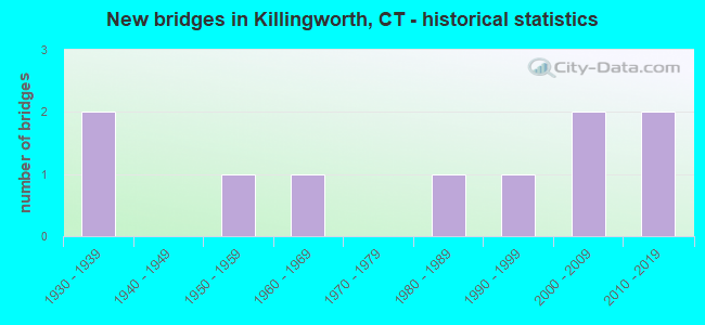
- New bridges - historical statistics
- 21930-1939
- 11950-1959
- 11960-1969
- 11980-1989
- 11990-1999
- 22000-2009
- 22010-2019
FCC Registered Cell Phone Towers:
3 (See the full list of FCC Registered Cell Phone Towers in Killingworth)FCC Registered Antenna Towers:
15 (See the full list of FCC Registered Antenna Towers)FCC Registered Broadcast Land Mobile Towers:
4- Killingworth Fire Headquarters Rt 81 (Lat: 41.292583 Lon: -72.880944), Call Sign: KNJX342, Licensee ID: L00003709,
Assigned Frequencies: 46.1600 MHz, Grant Date: 07/15/1999, Expiration Date: 08/24/2004, Cancellation Date: 10/30/2004, Registrant: Connecticut Fire Chiefs Association, 1111 Country Club Rd, Middletown, CT 06457-9294, Phone: (203) 822-6028
- Town Hall Rt 81 (Lat: 41.362889 Lon: -72.565639), Call Sign: KNCQ749,
Assigned Frequencies: 153.800 MHz, Grant Date: 11/22/1996, Expiration Date: 02/02/2002, Cancellation Date: 05/05/2002, Registrant: Killingworth, Town Of, 323 Rt 81, Killingworth, CT 06419
- .2 Mi Off Rt 81 2 Mi N (Lat: 41.395944 Lon: -72.558139), Call Sign: KNAY537,
Assigned Frequencies: 463.225 MHz, Grant Date: 02/03/1996, Expiration Date: 03/06/2001, Cancellation Date: 05/06/2001, Registrant: David Bartlett Waste Removal, 196 Hemlock Ave, North Guilford, CT 06437, Phone: (203) 452-0800
- Rt 80 & 81 (Lat: 41.359833 Lon: -72.541194), Call Sign: KSK898,
Assigned Frequencies: 31.8800 MHz, Grant Date: 11/14/1996, Expiration Date: 01/12/2002, Cancellation Date: 05/05/2002, Registrant: Amerigas Propane Inc, Valley Forge, PA 19482, Phone: (215) 337-7000
FCC Registered Microwave Towers:
6 (See the full list of FCC Registered Microwave Towers in this town)FCC Registered Paging Towers:
4 (See the full list of FCC Registered Paging Towers)FCC Registered Amateur Radio Licenses:
44 (See the full list of FCC Registered Amateur Radio Licenses in Killingworth)FAA Registered Aircraft:
7- Aircraft: CESSNA 170B (Category: Land, Seats: 4, Weight: Up to 12,499 Pounds, Speed: 105 mph), Engine: CONT MOTOR C145 SERIES (145 HP) (Reciprocating)
N-Number: 2891C, N2891C, N-2891C, Serial Number: 26434, Year manufactured: 1954, Airworthiness Date: 04/13/1956, Certificate Issue Date: 06/12/1996
Registrant (Individual): Edward P Oconnell, 143 Old County Rd, Killingworth, CT 06419 - Aircraft: CESSNA 172F (Category: Land, Seats: 4, Weight: Up to 12,499 Pounds, Speed: 105 mph), Engine: LYCOMING O&VO-360 SER (180 HP) (Reciprocating)
N-Number: 5468R, N5468R, N-5468R, Serial Number: 17253027, Year manufactured: 1965, Airworthiness Date: 09/26/1980, Certificate Issue Date: 12/11/2017
Registrant (Corporation): Cw Arborists Ltd, 32 Chatfield Ridge Rd, Killingworth, CT 06419 - Aircraft: LEWIS JACOB T JR TRIOLT (Category: Land, Seats: 4, Weight: Up to 12,499 Pounds), Engine: AMA/EXPR UNKNOWN ENG (Reciprocating)
N-Number: 6359N, N6359N, N-6359N, Serial Number: 1, Year manufactured: 2000, Airworthiness Date: 09/09/2001, Certificate Issue Date: 07/21/2006
Registrant (Individual): Kevin John Nichols, 74 Pond Meadow Rd, Killingworth, CT 06419 - Aircraft: PAVLOU KANELLOS 601XL (Category: Land, Seats: 2, Weight: Up to 12,499 Pounds), Engine: AMA/EXPR UNKNOWN ENG (Reciprocating)
N-Number: 678AK, N678AK, N-678AK, Serial Number: 6-6985, Year manufactured: 2014, Airworthiness Date: 04/04/2014, Certificate Issue Date: 02/25/2010
Registrant (Individual): Kanellos Pavlou, 39 Roast Meat Hill Rd, Killingworth, CT 06419 - Aircraft: CESSNA 172L (Category: Land, Seats: 4, Weight: Up to 12,499 Pounds, Speed: 105 mph), Engine: LYCOMING 0-320 SERIES (180 HP) (Reciprocating)
N-Number: 7142Q, N7142Q, N-7142Q, Serial Number: 17260442, Airworthiness Date: 10/15/1987, Certificate Issue Date: 02/15/2012
Registrant (Individual): Richard M Obymachow, 2 Blueberry Hill, Killingworth, CT 06419 - Aircraft: ROBINSON HELICOPTER R44 (Category: Land, Seats: 4, Weight: Up to 12,499 Pounds), Engine: LYCOMING 0-540F1 SERIE (260 HP) (Reciprocating)
N-Number: 921JA, N921JA, N-921JA, Serial Number: 1188, Year manufactured: 2002, Airworthiness Date: 03/13/2002, Certificate Issue Date: 06/08/2010
Registrant (Individual): Colin J Mclaren, 37 Bunkerhill Rd, Killingworth, CT 06419 - Aircraft: MORAVAN Z143L (Category: Land, Seats: 4, Weight: Up to 12,499 Pounds), Engine: LYCOMING 0-540 SERIES (250 HP) (Reciprocating)
N-Number: 143GW, N143GW, N-143GW, Serial Number: 0039, Year manufactured: 2001, Airworthiness Date: 04/05/2001, Certificate Issue Date: 11/07/2018
Registrant (Individual): Wilhelm Abert Steinhilber, 260 Green Hill Rd, Killingworth, CT 06419
Deregistered: Cancel Date: 10/04/2019, Exported to: Canada
2002 - 2018 National Fire Incident Reporting System (NFIRS) incidents
- Fire incident types reported to NFIRS in Killingworth, CT
- 28971.2%Structure Fires
- 7318.0%Outside Fires
- 317.6%Mobile Property/Vehicle Fires
- 133.2%Other
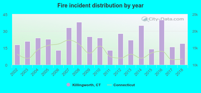 Based on the data from the years 2002 - 2018 the average number of fires per year is 24. The highest number of fires - 40 took place in 2016, and the least - 13 in 2006. The data has a growing trend.
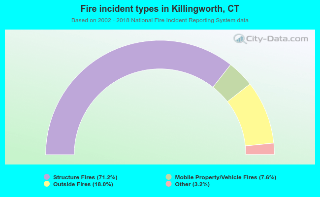 When looking into fire subcategories, the most incidents belonged to: Structure Fires (71.2%), and Outside Fires (18.0%).
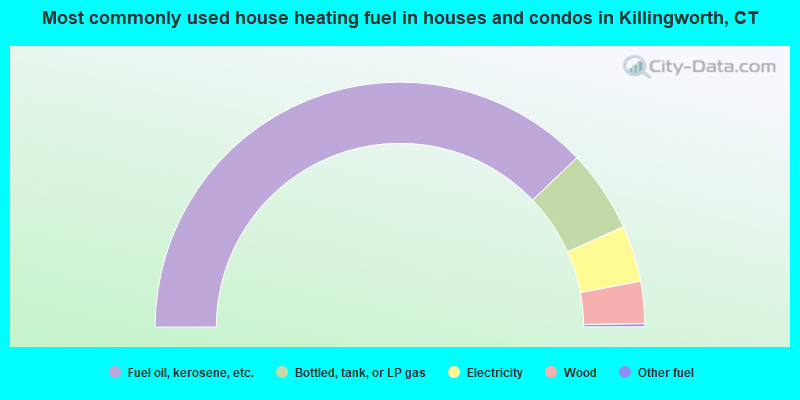
- 75.7%Fuel oil, kerosene, etc.
- 10.9%Bottled, tank, or LP gas
- 7.4%Electricity
- 5.6%Wood
- 0.4%Other fuel
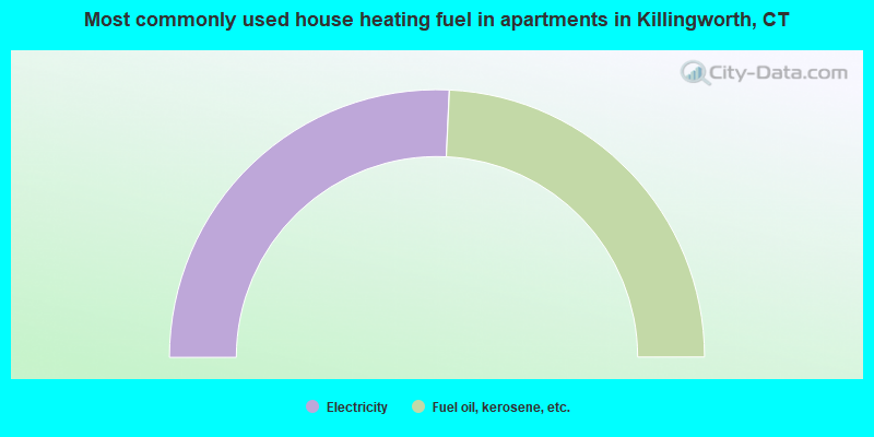
- 51.5%Electricity
- 48.5%Fuel oil, kerosene, etc.
Killingworth compared to Connecticut state average:
- Unemployed percentage significantly below state average.
- Black race population percentage significantly below state average.
- Hispanic race population percentage significantly below state average.
- Median age above state average.
- Foreign-born population percentage significantly below state average.
- Renting percentage significantly below state average.
- Length of stay since moving in significantly above state average.
- Number of rooms per house significantly below state average.
- House age significantly below state average.
- Percentage of population with a bachelor's degree or higher above state average.
Killingworth on our top lists:
- #1 on the list of "Top 101 cities with largest percentage of females in occupations: secondary school teachers (population 5,000+)"
- #2 on the list of "Top 101 cities with largest percentage of males in occupations: secondary school teachers (population 5,000+)"
- #5 on the list of "Top 101 cities with largest percentage of females in occupations: judges, magistrates, and other judicial workers (population 5,000+)"
- #6 on the list of "Top 101 cities with largest percentage of females in industries: paper and paper products merchant wholesalers (population 5,000+)"
- #7 on the list of "Top 101 cities with largest percentage of females in occupations: sales representatives, services, wholesale and manufacturing (population 5,000+)"
- #19 on the list of "Top 101 cities with largest percentage of females in occupations: plant and system operators (population 5,000+)"
- #22 on the list of "Top 101 cities with largest percentage of females in industries: clothing and accessories, including shoe, stores (population 5,000+)"
- #33 on the list of "Top 101 cities with largest percentage of males in industries: broadcasting and telecommunications (population 5,000+)"
- #34 on the list of "Top 101 cities with largest percentage of males in occupations: engineers (population 5,000+)"
- #35 on the list of "Top 101 cities with largest percentage of females in industries: sporting goods, camera, and hobby and toy stores (population 5,000+)"
- #37 on the list of "Top 101 cities with largest percentage of females in industries: nonmetallic mineral products (population 5,000+)"
- #41 on the list of "Top 101 cities with largest percentage of males in industries: furniture and home furnishing merchant wholesalers (population 5,000+)"
- #48 on the list of "Top 101 cities with largest percentage of males in industries: drugs, sundries, and chemical and allied products merchant wholesalers (population 5,000+)"
- #50 on the list of "Top 101 cities with largest percentage of males in industries: professional and commercial equipment and supplies merchant wholesalers (population 5,000+)"
- #51 on the list of "Top 101 cities with largest percentage of females in industries: hardware, plumbing and heating equipment, and supplies merchant wholesalers (population 5,000+)"
- #62 on the list of "Top 101 cities with largest percentage of females in industries: drugs, sundries, and chemical and allied products merchant wholesalers (population 5,000+)"
- #64 on the list of "Top 101 cities with largest percentage of males in industries: chemicals (population 5,000+)"
- #76 on the list of "Top 101 cities with largest percentage of females in industries: electrical equipment, appliances, and components (population 5,000+)"
- #76 on the list of "Top 101 cities with largest percentage of males in industries: publishing, and motion picture and sound recording industries (population 5,000+)"
- #87 on the list of "Top 101 cities with the lowest percentage of single-parent households, population 5,000+"
- #4 on the list of "Top 101 counties with the highest percentage of residents that visited a dentist within the past year"
- #11 on the list of "Top 101 counties with the best general health status score of residents (1-5), 3 years of data"
- #17 on the list of "Top 101 counties with the lowest number of births per 1000 residents 2007-2013"
- #25 on the list of "Top 101 counties with the highest average weight of females"
- #32 on the list of "Top 101 counties with the largest decrease in the number of births per 1000 residents 2000-2006 to 2007-2013 (pop 50,000+)"

|
|
Total of 324 patent applications in 2008-2024.