Hondo, New Mexico
Submit your own pictures of this place and show them to the world
- OSM Map
- General Map
- Google Map
- MSN Map

| Males: 549 | |
| Females: 532 |
| Median resident age: | 40.4 years |
| New Mexico median age: | 34.6 years |
Zip code: 88343
| Hondo: | $41,232 |
| NM: | $59,726 |
Estimated per capita income in 2022: $23,606 (it was $14,033 in 2000)
Hondo CCD income, earnings, and wages data
Estimated median house or condo value in 2022: $245,336 (it was $101,200 in 2000)
| Hondo: | $245,336 |
| NM: | $243,100 |
Detailed information about poverty and poor residents in Hondo, NM


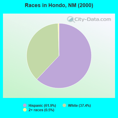
- 62861.9%Hispanic
- 37937.4%White alone
- 50.5%Two or more races
- 10.10%American Indian alone
- 10.10%Native Hawaiian and Other
Pacific Islander alone
Races in Hondo detailed stats: ancestries, foreign born residents, place of birth
 Recent articles from our blog. Our writers, many of them Ph.D. graduates or candidates, create easy-to-read articles on a wide variety of topics.
Current Local Time: MST time zone
Elevation: 5220 feet
Land area: 690.6 square miles.
Population density: 1.6 people per square mile (very low).

| Hondo CCD: | 0.4% ($365) |
| New Mexico: | 0.7% ($699) |
Nearest city with pop. 50,000+: Las Cruces, NM  (117.1 miles , pop. 74,267).
Nearest city with pop. 200,000+: El Paso, TX (130.5 miles , pop. 563,662).
Nearest city with pop. 1,000,000+: Phoenix, AZ (398.9 miles , pop. 1,321,045).
Nearest cities:
), Latitude: 33.35 N, Longitude: 105.17 W
Area code: 505

| Here: | 3.4% |
| New Mexico: | 3.6% |
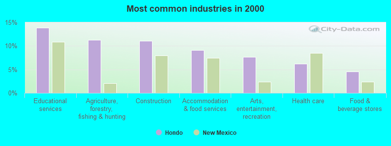
- Educational services (13.9%)
- Agriculture, forestry, fishing & hunting (11.3%)
- Construction (11.0%)
- Accommodation & food services (9.1%)
- Arts, entertainment, recreation (7.7%)
- Health care (6.2%)
- Food & beverage stores (4.6%)
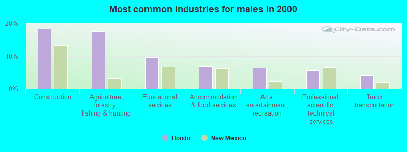
- Construction (18.3%)
- Agriculture, forestry, fishing & hunting (17.5%)
- Educational services (9.6%)
- Accommodation & food services (6.8%)
- Arts, entertainment, recreation (6.4%)
- Professional, scientific, technical services (5.6%)
- Truck transportation (4.0%)
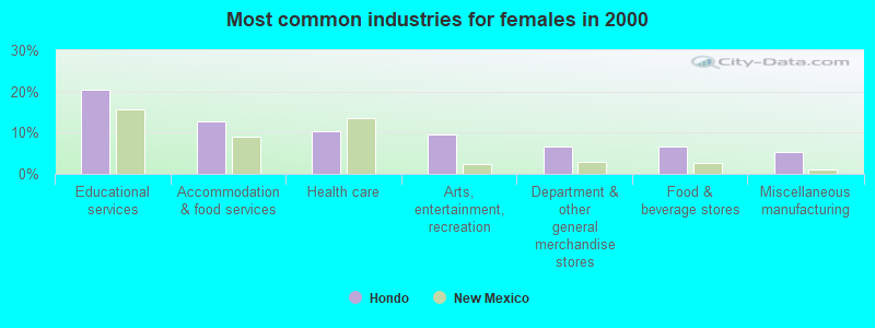
- Educational services (20.5%)
- Accommodation & food services (12.7%)
- Health care (10.2%)
- Arts, entertainment, recreation (9.6%)
- Department & other general merchandise stores (6.6%)
- Food & beverage stores (6.6%)
- Miscellaneous manufacturing (5.4%)
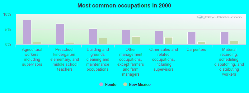
- Agricultural workers, including supervisors (8.2%)
- Preschool, kindergarten, elementary, and middle school teachers (7.0%)
- Building and grounds cleaning and maintenance occupations (5.3%)
- Other management occupations, except farmers and farm managers (4.8%)
- Other sales and related occupations, including supervisors (4.6%)
- Carpenters (4.1%)
- Material recording, scheduling, dispatching, and distributing workers (4.1%)
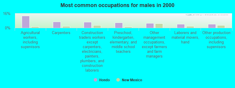
- Agricultural workers, including supervisors (13.5%)
- Carpenters (6.8%)
- Construction traders workers except carpenters, electricians, painters, plumbers, and construction laborers (6.4%)
- Preschool, kindergarten, elementary, and middle school teachers (6.0%)
- Other management occupations, except farmers and farm managers (5.2%)
- Laborers and material movers, hand (4.4%)
- Other production occupations, including supervisors (4.4%)
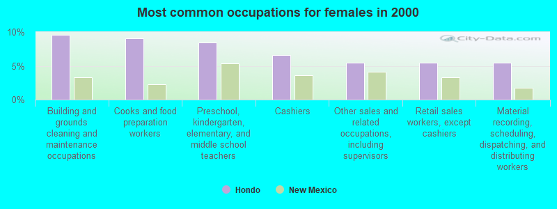
- Building and grounds cleaning and maintenance occupations (9.6%)
- Cooks and food preparation workers (9.0%)
- Preschool, kindergarten, elementary, and middle school teachers (8.4%)
- Cashiers (6.6%)
- Other sales and related occupations, including supervisors (5.4%)
- Retail sales workers, except cashiers (5.4%)
- Material recording, scheduling, dispatching, and distributing workers (5.4%)
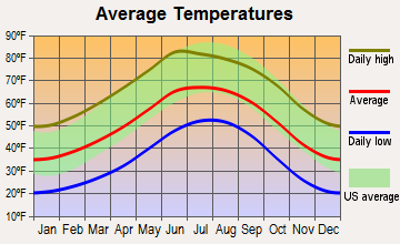
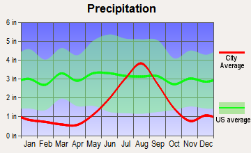
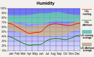
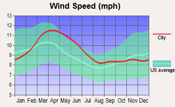
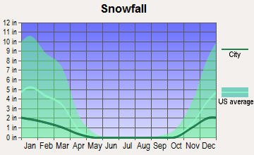
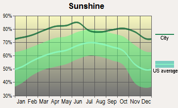
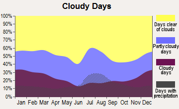
Average climate in Hondo, New Mexico
Based on data reported by over 4,000 weather stations
Earthquake activity:
Hondo-area historical earthquake activity is significantly above New Mexico state average. It is 457% greater than the overall U.S. average.On 4/14/1995 at 00:32:56, a magnitude 5.7 (5.6 MB, 5.7 MS, 5.7 MW, Depth: 11.1 mi, Class: Moderate, Intensity: VI - VII) earthquake occurred 237.5 miles away from Hondo center
On 3/26/2020 at 15:16:27, a magnitude 5.0 (5.0 MW, Depth: 5.9 mi) earthquake occurred 130.8 miles away from Hondo center
On 1/2/1992 at 11:45:35, a magnitude 5.0 (4.6 MB, 5.0 LG, Depth: 3.1 mi) earthquake occurred 139.2 miles away from Hondo center
On 1/29/1990 at 13:16:10, a magnitude 4.8 (4.5 MB, 4.8 LG, Depth: 7.5 mi, Class: Light, Intensity: IV - V) earthquake occurred 124.7 miles away from the city center
On 6/29/2014 at 04:59:35, a magnitude 5.3 (5.3 MW, Depth: 4.0 mi) earthquake occurred 238.2 miles away from the city center
On 6/16/1978 at 11:46:54, a magnitude 5.3 (4.4 MB, 4.6 UK, 5.3 ML) earthquake occurred 255.7 miles away from Hondo center
Magnitude types: regional Lg-wave magnitude (LG), body-wave magnitude (MB), local magnitude (ML), surface-wave magnitude (MS), moment magnitude (MW)
Natural disasters:
The number of natural disasters in Lincoln County (24) is greater than the US average (15).Major Disasters (Presidential) Declared: 14
Emergencies Declared: 2
Causes of natural disasters: Floods: 11, Fires: 9, Storms: 9, Winter Storms: 2, Hurricane: 1, Mudslide: 1, Snow: 1, Other: 1 (Note: some incidents may be assigned to more than one category).
Colleges/universities with over 2000 students nearest to Hondo:
- Eastern New Mexico University-Roswell Campus (about 38 miles; Roswell, NM; Full-time enrollment: 2,212)
- New Mexico State University-Main Campus (about 118 miles; Las Cruces, NM; FT enrollment: 14,497)
- New Mexico State University-Dona Ana (about 119 miles; Las Cruces, NM; FT enrollment: 5,640)
- Eastern New Mexico University-Main Campus (about 120 miles; Portales, NM; FT enrollment: 4,263)
- El Paso Community College (about 130 miles; El Paso, TX; FT enrollment: 19,576)
- Vista College (about 131 miles; El Paso, TX; FT enrollment: 3,453)
- The University of Texas at El Paso (about 135 miles; El Paso, TX; FT enrollment: 18,008)
Public high school in Hondo:
- HONDO HIGH (Students: 59, Location: US HWY 70 AND HWY 380, Grades: 7-12)
Public elementary/middle school in Hondo:
- HONDO ELEMENTARY (Students: 68, Location: US HWY 70 AND HWY 380, Grades: PK-6)
Points of interest:
Notable locations in Hondo: Lake Windmill (A), LeRoy McKnight Ranch (B), McKnight Ranch (C), Nelson Ranch (D), Nuñez Ranch (E), Old Fears Ranch (F), Old Pruit Ranch (G), Percella Ranch (H), Peters Ranch (I), Rosendo Windmill (J), Slaughter Ranch (K), Spring (L), Torres Ranch (M), Treat Ranch (N), Wilbur McKnight Ranch (O), Watson Ranch (P), Whitetail Windmill (Q), Riley Ranch (R), Lincoln County Livestock Company (S), Bar H Farm (T). Display/hide their locations on the map
Churches in Hondo include: First Baptist Church (A), Mission Fountain of Living Water Full Gospel (B), Saint Annes Chapel (C). Display/hide their locations on the map
Cemeteries: Glencoe Cemetery (1), Fritz Cemetery (2), Lincoln Cemetery (3). Display/hide their locations on the map
Lakes and reservoirs: Little Flying H Lake (A), Deep Lake (B), Pond Lake (C), Galles Lake (D), South Lake (E), Lost Lake (F), Circle Diamond Lake (G), Burro Lake (H). Display/hide their locations on the map
Streams, rivers, and creeks: Rio Bonito (A), Rio Ruidoso (B), Eagle Creek (C), Baca Spring Creek (D). Display/hide their locations on the map
Parks in Hondo include: Lincoln Historical Marker (1), Lincoln State Monument Point of Interest (2). Display/hide their locations on the map
Drinking water stations with addresses in Hondo and their reported violations in the past:
TINNIES SILVER DOLLAR RESTAURANT (Address: 28842 HIGHWAY 70 , Population served: 50, Groundwater):Past monitoring violations:
- 3 routine major monitoring violations
| This place: | 2.4 people |
| New Mexico: | 2.5 people |
| This place: | 68.9% |
| Whole state: | 65.5% |
| This place: | 7.6% |
| Whole state: | 8.2% |
Likely homosexual households (counted as self-reported same-sex unmarried-partner households)
- Lesbian couples: 0.5% of all households
- Gay men: 0.5% of all households
| This place: | 23.1% |
| Whole state: | 18.4% |
| This place: | 9.1% |
| Whole state: | 7.8% |
For population 15 years and over in Hondo:
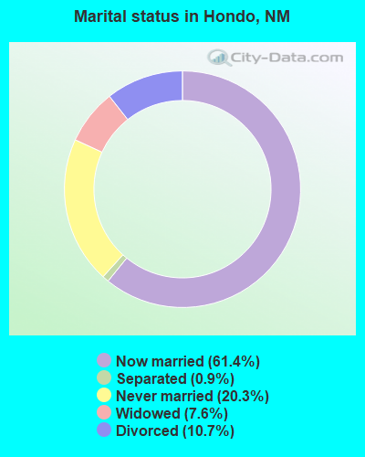
- Never married: 20.3%
- Now married: 61.4%
- Separated: 0.9%
- Widowed: 7.6%
- Divorced: 10.7%
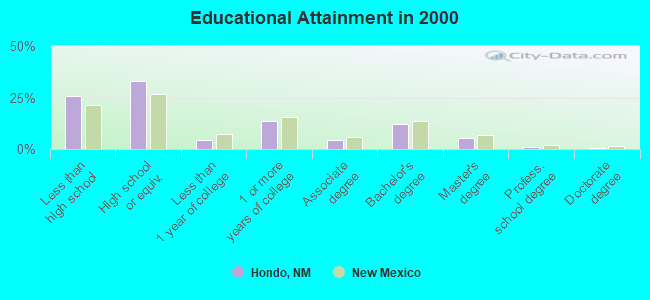
For population 25 years and over in Hondo:
- High school or higher: 74.4%
- Bachelor's degree or higher: 18.5%
- Graduate or professional degree: 6.6%
- Unemployed: 5.7%
- Mean travel time to work (commute): 23.7 minutes
| Here: | 14.7 |
| New Mexico average: | 14.5 |
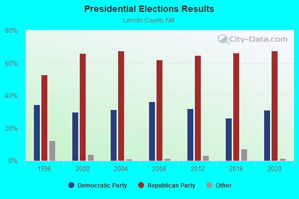
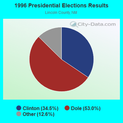
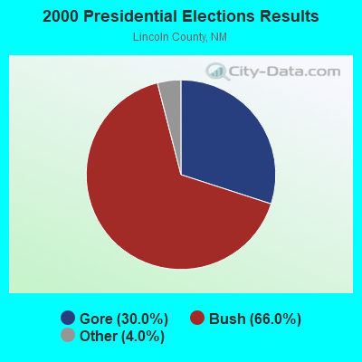


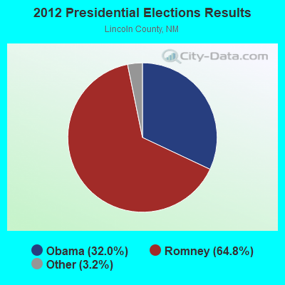
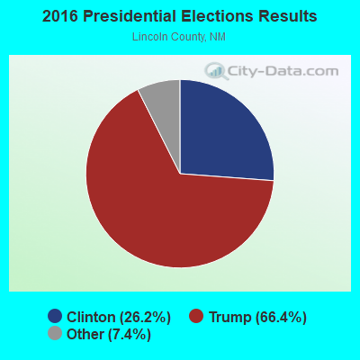

Graphs represent county-level data. Detailed 2008 Election Results
Religion statistics for Hondo, NM (based on Lincoln County data)
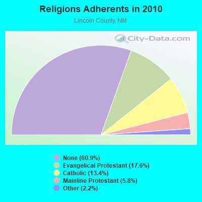
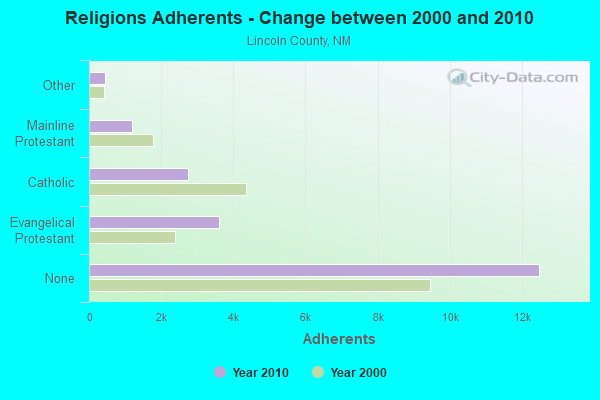
| Religion | Adherents | Congregations |
|---|---|---|
| Evangelical Protestant | 3,611 | 25 |
| Catholic | 2,745 | 9 |
| Mainline Protestant | 1,194 | 10 |
| Other | 457 | 2 |
| None | 12,490 | - |
Food Environment Statistics:
| Lincoln County: | 1.93 / 10,000 pop. |
| New Mexico: | 1.44 / 10,000 pop. |
| Lincoln County: | 0.48 / 10,000 pop. |
| State: | 0.21 / 10,000 pop. |
| Lincoln County: | 6.28 / 10,000 pop. |
| State: | 4.06 / 10,000 pop. |
| Lincoln County: | 17.39 / 10,000 pop. |
| State: | 7.12 / 10,000 pop. |
| Lincoln County: | 6.2% |
| New Mexico: | 6.4% |
| Lincoln County: | 17.4% |
| State: | 22.1% |
| Lincoln County: | 13.8% |
| New Mexico: | 11.5% |
Strongest AM radio stations in Hondo:
- KINF (1020 AM; 50 kW; ROSWELL, NM; Owner: JAMES CRYSTAL HOLDINGS OF NEW MEXICO, INC.)
- KBUY (1360 AM; 5 kW; RUIDOSO, NM; Owner: WALTON STATIONS-NEW MEXICO, INC.)
- KBIM (910 AM; 5 kW; ROSWELL, NM; Owner: KING BROADCASTING COMPANY)
- KCRX (1430 AM; 5 kW; ROSWELL, NM; Owner: ROSENDO CASAREZ, JR.)
- KICA (980 AM; 50 kW; CLOVIS, NM; Owner: BROADCAST ENTERTAINMENT CORPORATION)
- KKOB (770 AM; 50 kW; ALBUQUERQUE, NM; Owner: CITADEL BROADCASTING COMPANY)
- KMUL (1380 AM; 50 kW; MULESHOE, TX; Owner: BROADCAST ENTERTAINMENT CORPORATION)
- KELP (1590 AM; 50 kW; EL PASO, TX; Owner: MCCLATCHEY BROADCASTING)
- KRUI (1490 AM; 1 kW; RUIDOSO DOWNS, NM; Owner: M.T.D., INC.)
- KTSM (690 AM; 10 kW; EL PASO, TX; Owner: CCB TEXAS LICENSES, L.P.)
- KTNN (660 AM; 50 kW; WINDOW ROCK, AZ; Owner: THE NAVAJO NATION)
- KAMA (750 AM; 10 kW; EL PASO, TX; Owner: TICHENOR LICENSE CORPORATION ("TLC"))
- KHAC (880 AM; 43 kW; TSE BONITO, NM; Owner: WESTERN INDIAN MINISTRIES, INC.)
Strongest FM radio stations in Hondo:
- K249DD (97.7 FM; RUIDOSO, NM; Owner: ROSWELL CHRISTIAN RADIO, INC.)
- KNMB (96.7 FM; CLOUDCROFT, NM; Owner: MTD, INC.)
- KIDX (101.5 FM; RUIDOSO, NM; Owner: MTD, INC.)
- K240CN (95.9 FM; RUIDOSO, NM; Owner: FRIENDS OF KHFM-RUIDOSO)
- K297AE (107.3 FM; RUIDOSO, NM; Owner: FAMILY LIFE BROADCASTING SYSTEM)
- KSFX (100.5 FM; ROSWELL, NM; Owner: ROSWELL RADIO, INC.)
- K205DE (88.9 FM; ALAMOGORDO, NM; Owner: PAULINO BERNAL EVANGELISM)
- K256AI (99.1 FM; ALAMOGORDO, NM; Owner: CALVARY CHAPEL OF TWIN FALLS, INC.)
- KZZX (105.3 FM; ALAMOGORDO, NM; Owner: BURT BROADCASTING, INC.)
- K215EC (91.1 FM; ALAMOGORDO, NM; Owner: CALVARY CHAPEL OF TWIN FALLS, INC.)
FCC Registered Microwave Towers:
1- HONDO, Sw/4 Section 5, Township 11 South, Range 17 East (Lat: 33.382472 Lon: -105.289556), Type: Ltower, Structure height: 57.3 m, Call Sign: WQTN761,
Assigned Frequencies: 6365.26 MHz, Grant Date: 03/13/2014, Expiration Date: 03/13/2024, Cancellation Date: 08/24/2015, Certifier: Michael P Goggin, Registrant: At&t Mobility LLC, 3300 E. Renner Road, B3132, Richardson, TX 75082, Phone: (855) 699-7073, Fax: (972) 907-1131, Email:
FCC Registered Amateur Radio Licenses:
1- Call Sign: W5EJ, Licensee ID: L00147506, Grant Date: 04/03/1997, Expiration Date: 02/11/2007, Cancellation Date: 03/31/2003, Registrant: Ed Juge, 3698 Los Chozas Trail, Hondo, NM 88336
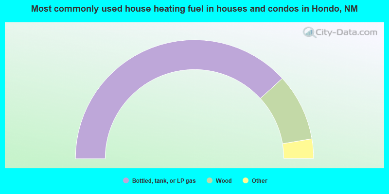
- 76.4%Bottled, tank, or LP gas
- 18.3%Wood
- 2.7%Utility gas
- 2.0%Electricity
- 0.7%Other fuel

- 76.3%Bottled, tank, or LP gas
- 19.4%Wood
- 4.3%Electricity
Hondo compared to New Mexico state average:
- Unemployed percentage below state average.
- Black race population percentage significantly below state average.
- Foreign-born population percentage significantly below state average.
- Length of stay since moving in significantly above state average.
- Number of rooms per house significantly below state average.
- House age significantly below state average.