Farmington, Connecticut
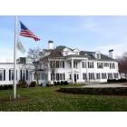
Farmington: FARMINGTON, CT - COUNTRY CLUB
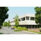
Farmington: office
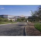
Farmington: farmington
Farmington: rapper 50 cents home
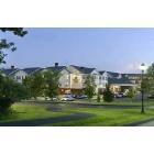
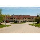
Farmington: hotel
- add
your


Submit your own pictures of this town and show them to the world
- OSM Map
- General Map
- Google Map
- MSN Map

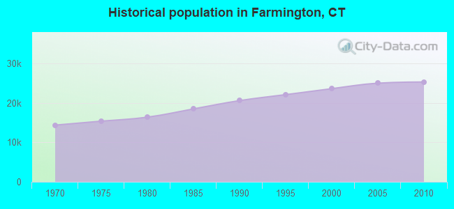
Population change since 2000: +7.2%
 |
| Males: 12,072 | |
| Females: 13,268 |
| Median resident age: | 44.2 years |
| Connecticut median age: | 39.2 years |
Zip codes: 06032.
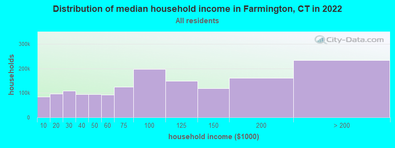
| Farmington: | $109,969 |
| CT: | $88,429 |
Estimated per capita income in 2022: $70,115 (it was $39,102 in 2000)
Farmington town income, earnings, and wages data
Estimated median house or condo value in 2022: $399,518 (it was $184,800 in 2000)
| Farmington: | $399,518 |
| CT: | $347,200 |
Mean prices in 2022: all housing units: $326,390; detached houses: $351,925; townhouses or other attached units: $238,893; in 2-unit structures: $226,606; in 3-to-4-unit structures: $205,937; in 5-or-more-unit structures: $157,099; mobile homes: $128,456
Detailed information about poverty and poor residents in Farmington, CT


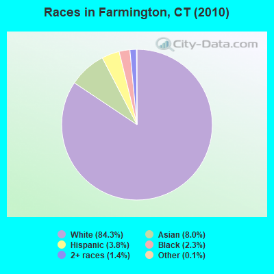
- 21,35684.3%White alone
- 2,0378.0%Asian alone
- 9663.8%Hispanic
- 5732.3%Black alone
- 3581.4%Two or more races
- 290.1%Other race alone
- 160.06%American Indian alone
- 50.02%Native Hawaiian and Other
Pacific Islander alone
Races in Farmington detailed stats: ancestries, foreign born residents, place of birth
According to our research of Connecticut and other state lists, there were 4 registered sex offenders living in Farmington, Connecticut as of May 08, 2024.
The ratio of all residents to sex offenders in Farmington is 6,335 to 1.
The ratio of registered sex offenders to all residents in this city is much lower than the state average.
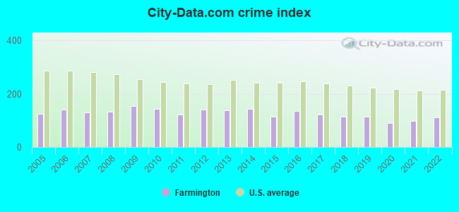
Type |
2009 |
2010 |
2011 |
2012 |
2013 |
2014 |
2015 |
2016 |
2017 |
2018 |
2019 |
2020 |
2021 |
2022 |
|---|---|---|---|---|---|---|---|---|---|---|---|---|---|---|
| Murders (per 100,000) | 0 (0.0) | 0 (0.0) | 0 (0.0) | 0 (0.0) | 0 (0.0) | 0 (0.0) | 0 (0.0) | 0 (0.0) | 0 (0.0) | 0 (0.0) | 0 (0.0) | 0 (0.0) | 0 (0.0) | 1 (3.8) |
| Rapes (per 100,000) | 6 (23.7) | 6 (23.7) | 0 (0.0) | 2 (7.9) | 3 (11.7) | 6 (23.4) | 3 (11.7) | 4 (15.6) | 4 (15.7) | 4 (15.6) | 0 (0.0) | 2 (7.8) | 5 (19.6) | 4 (15.0) |
| Robberies (per 100,000) | 9 (35.6) | 4 (15.8) | 12 (47.3) | 17 (66.9) | 11 (43.0) | 12 (46.7) | 1 (3.9) | 10 (38.9) | 7 (27.4) | 5 (19.5) | 3 (11.8) | 1 (3.9) | 6 (23.5) | 7 (26.3) |
| Assaults (per 100,000) | 4 (15.8) | 1 (3.9) | 4 (15.8) | 5 (19.7) | 6 (23.4) | 2 (7.8) | 3 (11.7) | 3 (11.7) | 8 (31.3) | 5 (19.5) | 1 (3.9) | 5 (19.6) | 3 (11.8) | 5 (18.8) |
| Burglaries (per 100,000) | 52 (205.7) | 40 (157.9) | 54 (212.7) | 50 (196.6) | 47 (183.7) | 53 (206.4) | 33 (128.4) | 36 (140.2) | 40 (156.5) | 40 (156.2) | 107 (419.2) | 43 (168.5) | 35 (137.2) | 23 (86.4) |
| Thefts (per 100,000) | 610 (2,413) | 634 (2,502) | 565 (2,226) | 549 (2,159) | 592 (2,314) | 591 (2,302) | 541 (2,105) | 597 (2,324) | 464 (1,816) | 466 (1,820) | 466 (1,826) | 310 (1,215) | 334 (1,309) | 425 (1,597) |
| Auto thefts (per 100,000) | 28 (110.8) | 24 (94.7) | 7 (27.6) | 30 (118.0) | 20 (78.2) | 10 (38.9) | 24 (93.4) | 21 (81.8) | 33 (129.2) | 21 (82.0) | 28 (109.7) | 58 (227.3) | 36 (141.1) | 37 (139.0) |
| Arson (per 100,000) | 0 (0.0) | 4 (15.8) | 0 (0.0) | 1 (3.9) | 0 (0.0) | 0 (0.0) | 0 (0.0) | 0 (0.0) | 0 (0.0) | 0 (0.0) | 1 (3.9) | 0 (0.0) | 0 (0.0) | 0 (0.0) |
| City-Data.com crime index | 152.6 | 143.2 | 123.4 | 139.8 | 138.6 | 143.9 | 113.5 | 135.8 | 120.9 | 112.6 | 115.5 | 90.0 | 98.4 | 112.2 |
The City-Data.com crime index weighs serious crimes and violent crimes more heavily. Higher means more crime, U.S. average is 246.1. It adjusts for the number of visitors and daily workers commuting into cities.
Crime rate in Farmington detailed stats: murders, rapes, robberies, assaults, burglaries, thefts, arson
Full-time law enforcement employees in 2021, including police officers: 59 (45 officers - 40 male; 5 female).
| Officers per 1,000 residents here: | 1.76 |
| Connecticut average: | 2.10 |
 Recent articles from our blog. Our writers, many of them Ph.D. graduates or candidates, create easy-to-read articles on a wide variety of topics.


Latest news from Farmington, CT collected exclusively by city-data.com from local newspapers, TV, and radio stations
Farmington, CT City Guides:
Ancestries: Irish (21.3%), Italian (18.8%), Polish (14.3%), English (13.3%), German (11.6%), French (6.0%).
Current Local Time: EST time zone
Incorporated on 12/1645
Elevation: 245 feet
Land area: 28.1 square miles.
Population density: 903 people per square mile (low).
2,807 residents are foreign born (6.5% Europe, 3.4% Asia).
| This town: | 11.9% |
| Connecticut: | 10.9% |
| Farmington town: | 1.5% ($2,806) |
| Connecticut: | 1.8% ($2,961) |
Nearest city with pop. 50,000+: New Britain, CT  (5.3 miles , pop. 71,538).
Nearest city with pop. 200,000+: North Hempstead, NY (78.6 miles , pop. 222,611).
Nearest city with pop. 1,000,000+: Bronx, NY (81.1 miles , pop. 1,332,650).
Nearest cities:
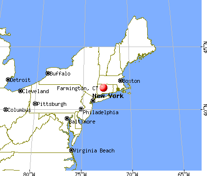
), Latitude: 41.73 N, Longitude: 72.85 W
Area code: 860
Farmington tourist attractions:
Farmington, Connecticut accommodation & food services, waste management - Economy and Business Data
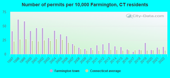
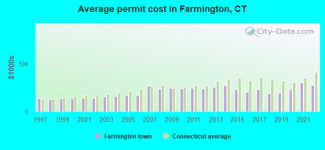
Single-family new house construction building permits:
- 2022: 32 buildings, average cost: $277,600
- 2021: 28 buildings, average cost: $305,700
- 2020: 19 buildings, average cost: $232,700
- 2019: 48 buildings, average cost: $194,800
- 2018: 20 buildings, average cost: $187,200
- 2017: 11 buildings, average cost: $231,900
- 2016: 21 buildings, average cost: $204,900
- 2015: 31 buildings, average cost: $233,500
- 2014: 34 buildings, average cost: $273,800
- 2013: 48 buildings, average cost: $259,800
- 2012: 43 buildings, average cost: $241,800
- 2011: 38 buildings, average cost: $248,600
- 2010: 27 buildings, average cost: $243,600
- 2009: 23 buildings, average cost: $244,600
- 2008: 28 buildings, average cost: $239,200
- 2007: 44 buildings, average cost: $270,200
- 2006: 77 buildings, average cost: $173,800
- 2005: 84 buildings, average cost: $173,900
- 2004: 100 buildings, average cost: $159,800
- 2003: 69 buildings, average cost: $158,300
- 2002: 111 buildings, average cost: $143,200
- 2001: 110 buildings, average cost: $143,000
- 2000: 98 buildings, average cost: $137,400
- 1999: 139 buildings, average cost: $136,400
- 1998: 147 buildings, average cost: $124,600
- 1997: 97 buildings, average cost: $135,100
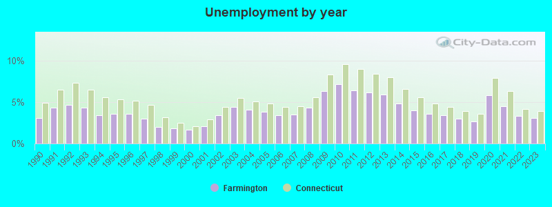
| Here: | 3.1% |
| Connecticut: | 3.9% |
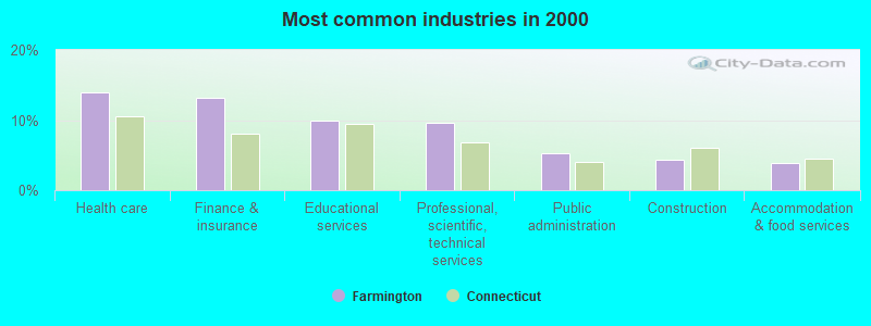
- Health care (13.9%)
- Finance & insurance (13.1%)
- Educational services (9.9%)
- Professional, scientific, technical services (9.6%)
- Public administration (5.2%)
- Construction (4.3%)
- Accommodation & food services (3.9%)
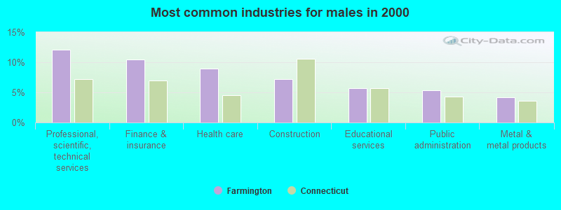
- Professional, scientific, technical services (12.0%)
- Finance & insurance (10.5%)
- Health care (9.0%)
- Construction (7.2%)
- Educational services (5.7%)
- Public administration (5.4%)
- Metal & metal products (4.2%)
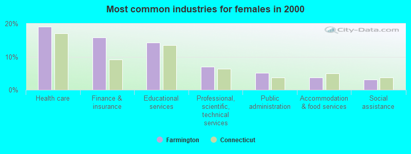
- Health care (19.1%)
- Finance & insurance (15.9%)
- Educational services (14.3%)
- Professional, scientific, technical services (6.9%)
- Public administration (5.1%)
- Accommodation & food services (3.7%)
- Social assistance (3.1%)
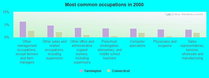
- Other management occupations, except farmers and farm managers (6.3%)
- Other sales and related occupations, including supervisors (4.7%)
- Other office and administrative support workers, including supervisors (3.8%)
- Preschool, kindergarten, elementary, and middle school teachers (3.6%)
- Computer specialists (3.5%)
- Physicians and surgeons (3.2%)
- Sales representatives, services, wholesale and manufacturing (3.1%)
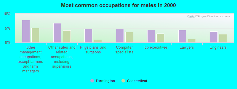
- Other management occupations, except farmers and farm managers (7.9%)
- Other sales and related occupations, including supervisors (6.7%)
- Physicians and surgeons (4.7%)
- Computer specialists (4.6%)
- Top executives (4.5%)
- Lawyers (4.3%)
- Engineers (3.8%)
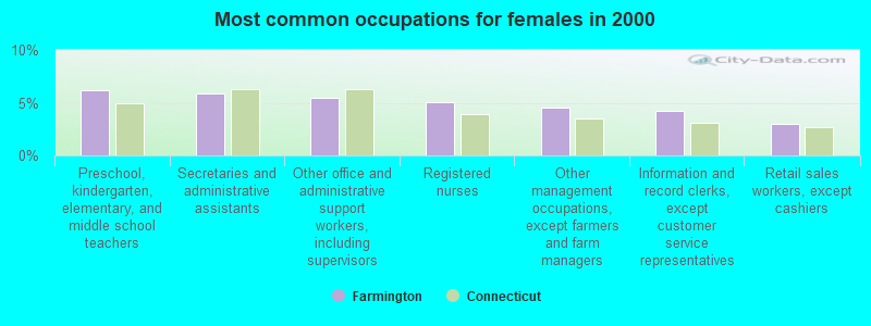
- Preschool, kindergarten, elementary, and middle school teachers (6.1%)
- Secretaries and administrative assistants (5.9%)
- Other office and administrative support workers, including supervisors (5.4%)
- Registered nurses (5.1%)
- Other management occupations, except farmers and farm managers (4.6%)
- Information and record clerks, except customer service representatives (4.2%)
- Retail sales workers, except cashiers (3.0%)
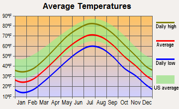
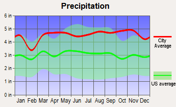
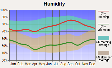
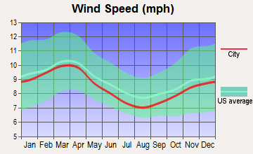
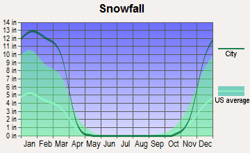
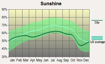
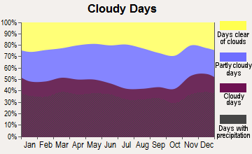
Average climate in Farmington, Connecticut
Based on data reported by over 4,000 weather stations
(lower is better)
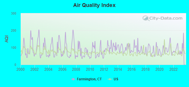
Air Quality Index (AQI) level in 2022 was 84.0. This is about average.
| City: | 84.0 |
| U.S.: | 72.6 |
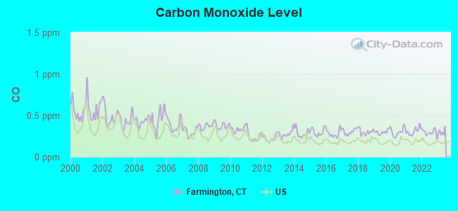
Carbon Monoxide (CO) [ppm] level in 2022 was 0.293. This is about average. Closest monitor was 5.7 miles away from the city center.
| City: | 0.293 |
| U.S.: | 0.251 |
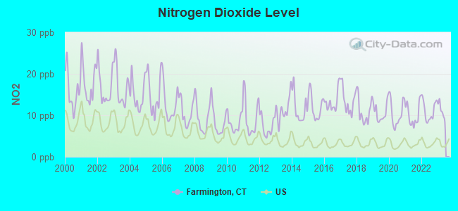
Nitrogen Dioxide (NO2) [ppb] level in 2022 was 11.1. This is significantly worse than average. Closest monitor was 4.6 miles away from the city center.
| City: | 11.1 |
| U.S.: | 5.1 |
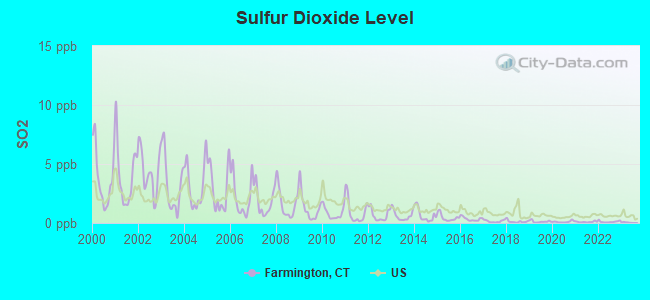
Sulfur Dioxide (SO2) [ppb] level in 2022 was 0.109. This is significantly better than average. Closest monitor was 4.6 miles away from the city center.
| City: | 0.109 |
| U.S.: | 1.515 |

Ozone [ppb] level in 2022 was 29.9. This is about average. Closest monitor was 5.7 miles away from the city center.
| City: | 29.9 |
| U.S.: | 33.3 |
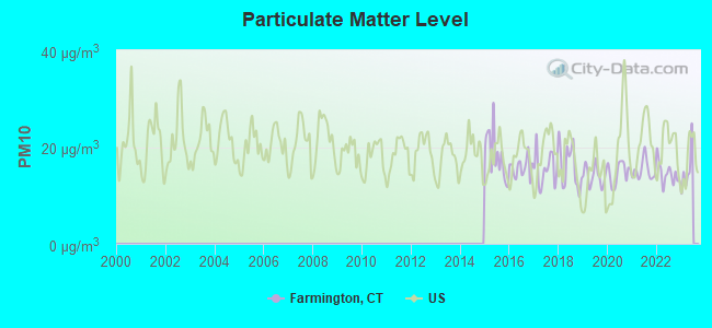
Particulate Matter (PM10) [µg/m3] level in 2022 was 14.5. This is better than average. Closest monitor was 5.0 miles away from the city center.
| City: | 14.5 |
| U.S.: | 19.2 |
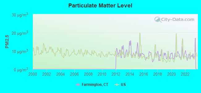
Particulate Matter (PM2.5) [µg/m3] level in 2022 was 7.20. This is about average. Closest monitor was 9.2 miles away from the city center.
| City: | 7.20 |
| U.S.: | 8.11 |
Tornado activity:
Farmington-area historical tornado activity is slightly above Connecticut state average. It is 19% smaller than the overall U.S. average.
On 10/3/1979, a category F4 (max. wind speeds 207-260 mph) tornado 13.8 miles away from the Farmington town center killed 3 people and injured 500 people and caused between $50,000,000 and $500,000,000 in damages.
On 7/10/1989, a category F4 tornado 24.5 miles away from the town center injured 40 people and caused between $50,000,000 and $500,000,000 in damages.
Earthquake activity:
Farmington-area historical earthquake activity is significantly above Connecticut state average. It is 70% smaller than the overall U.S. average.On 10/7/1983 at 10:18:46, a magnitude 5.3 (5.1 MB, 5.3 LG, 5.1 ML, Class: Moderate, Intensity: VI - VII) earthquake occurred 171.2 miles away from the city center
On 4/20/2002 at 10:50:47, a magnitude 5.3 (5.3 ML, Depth: 3.0 mi) earthquake occurred 196.9 miles away from Farmington center
On 4/20/2002 at 10:50:47, a magnitude 5.2 (5.2 MB, 4.2 MS, 5.2 MW, 5.0 MW) earthquake occurred 195.5 miles away from Farmington center
On 1/19/1982 at 00:14:42, a magnitude 4.7 (4.5 MB, 4.7 MD, 4.5 LG, Class: Light, Intensity: IV - V) earthquake occurred 137.8 miles away from the city center
On 10/16/2012 at 23:12:25, a magnitude 4.7 (4.7 ML, Depth: 10.0 mi) earthquake occurred 170.5 miles away from the city center
On 8/23/2011 at 17:51:04, a magnitude 5.8 (5.8 MW, Depth: 3.7 mi) earthquake occurred 377.9 miles away from the city center
Magnitude types: regional Lg-wave magnitude (LG), body-wave magnitude (MB), duration magnitude (MD), local magnitude (ML), surface-wave magnitude (MS), moment magnitude (MW)
Natural disasters:
The number of natural disasters in Hartford County (24) is greater than the US average (15).Major Disasters (Presidential) Declared: 13
Emergencies Declared: 11
Causes of natural disasters: Storms: 7, Hurricanes: 5, Floods: 4, Snowstorms: 4, Blizzards: 3, Snows: 3, Tropical Storms: 2, Winter Storms: 2, Snowfall: 1, Tornado: 1, Wind: 1 (Note: some incidents may be assigned to more than one category).

Main business address for: EDAC TECHNOLOGIES CORP (AIRCRAFT ENGINES & ENGINE PARTS).
Hospitals and medical centers in Farmington:
- C I B: WEST MEATH COMM RES (11 WEST MEATH LN)
- C R I: PLAINVILLE AVE GR HOME (723 PLAINVILLE AVE)
- JOHN DEMPSEY HOSPITAL (Government - Local, provides emergency services, 263 FARMINGTON AVE)
- AMBERWOODS OF FARMINGTON (416 COLT HIGHWAY)
- FARMINGTON REST HOME (RT 6 COLT HIGHWAY)
- TOUCHPOINTS AT FARMINGTON (SCOTT SWAMP RD)
- UCONN DIALYSIS CENTER (230 FARMINGTON AVENUE)
- GENTIVA HEALTH SERVICES (30 STANFORD DRIVE)
- INTERIM HEALTHCARE OF HARTFORD (231 FARMINGTON AVE)
Heliports located in Farmington:
See details about Heliports located in Farmington, CTAmtrak stations near Farmington:
- 9 miles: BERLIN (KENSINGTON, DEPOT RD.) . Services: ticket office, partially wheelchair accessible, enclosed waiting area, public restrooms, public payphones, free short-term parking, free long-term parking, call for car rental service, call for taxi service, public transit connection.
- 10 miles: HARTFORD (1 UNION PLACE) . Services: ticket office, partially wheelchair accessible, enclosed waiting area, public restrooms, public payphones, full-service food facilities, snack bar, vending machines, ATM, paid short-term parking, paid long-term parking, call for car rental service, taxi stand, intercity bus service, public transit connection.
- 14 miles: WINDSOR (41 CENTRAL ST.) . Services: enclosed waiting area, public restrooms, public payphones, free short-term parking, call for car rental service, call for taxi service, public transit connection.
Colleges/Universities in Farmington:
Other colleges/universities with over 2000 students near Farmington:
- Central Connecticut State University (about 6 miles; New Britain, CT; Full-time enrollment: 9,989)
- University of Hartford (about 9 miles; West Hartford, CT; FT enrollment: 6,398)
- Trinity College (about 9 miles; Hartford, CT; FT enrollment: 2,355)
- Capital Community College (about 10 miles; Hartford, CT; FT enrollment: 2,609)
- Goodwin College (about 11 miles; East Hartford, CT; FT enrollment: 3,017)
- Manchester Community College (about 15 miles; Manchester, CT; FT enrollment: 4,667)
- University of Connecticut-Tri-Campus (about 16 miles; Waterbury, CT; FT enrollment: 2,250)
Public high school in Farmington:
- FARMINGTON HIGH SCHOOL (Students: 1,049, Location: 10 MONTEITH DRIVE, Grades: 9-12)
Private high school in Farmington:
Public elementary/middle schools in Farmington:
- IRVING A. ROBBINS MIDDLE SCHOOL (Students: 725, Location: 20 WOLF PIT ROAD, Grades: 7-8)
- WEST WOODS UPPER ELEMENTARY SCHOOL (Students: 660, Location: 50 JUDSON LANE, Grades: 5-6)
- EAST FARMS SCHOOL (Students: 594, Location: 25 WOLF PIT ROAD, Grades: KG-4)
- NOAH WALLACE SCHOOL (Students: 472, Location: 2 SCHOOL STREET, Grades: KG-4)
Points of interest:
Notable locations in Farmington: Recreation Association Winding Trails Camp (A), Tunxis Plantation Country Club (B), Camp Courant (C), Westwoods Country Club (D), Farmington Industrial Park (E), Jacobs Corner (F), Lions Club Camp (G), Farmington Country Club (H), Farmington Club Polo Grounds (I), New Britain YMCA Camp (J), Farmington Fire Marshal's Office (K), Farmington Fire Department Farmington Fire Station (L), Unionville Museum (M), Farmington Fire Department / Tunxis Hose Fire Station (N), Tunxis Community College Library (O), The Farmington Library (P), Stanley-Whitman House Museum (Q), Julia Faxon Branch West Hartford Public Library (R), Hill-Stead Museum Library (S), Day-Lewis Museum (T). Display/hide their locations on the map
Shopping Centers: The Exchange Shopping Mall Shopping Center (1), Westfarms Shopping Center (2). Display/hide their locations on the map
Churches in Farmington include: Saint Marys Church (A), The Chapel (B), Holy Family Monastery (C), Church of Christ (D), First Church of Christ (E), Our Lady of Calvary Retreat (F), Philadelphia Missionary Baptist Church (G), Saint Brigid Church (H), Saint James Episcopal Church (I). Display/hide their locations on the map
Cemeteries: Hillside Cemetery (1), Riverside Cemetery (2), Old Farmington Cemetery (3), Old Cemetery (4). Display/hide their locations on the map
Lakes, reservoirs, and swamps: Walton Pond (A), Batterson Park Pond (B), South Reservoir (C), Farmington Reservoir (D), Lake Garda (E), Shade Swamp (F), Scott Swamp (G), Dead Wood Swamp (H). Display/hide their locations on the map
Streams, rivers, and creeks: Pequabuck River (A), Pope Brook (B), Poplar Swamp Brook (C), Roaring Brook (D), Unionville Brook (E), Great Brook (F), Hyde Brook (G). Display/hide their locations on the map
Parks in Farmington include: Farmington Historic District (1), Quirk Park (2), Town of Farmington Open Space (3), Carrington Park (4), Shade Swamp State Wildlife Area (5), Farmington River State Access Area (6). Display/hide their locations on the map
Tourist attractions: Avon Historical Society Museum (110 Main Street) (1), Hill-Stead Museum (35 Mountain Road) (2), Angus Steven V MD (Cultural Attractions- Events- & Facilities; 263 Farmington Avenue) (3), Allen Scott MD (Cultural Attractions- Events- & Facilities; 263 Farmington Avenue) (4), Chaudry Sarwat I MD (Cultural Attractions- Events- & Facilities; 263 Farmington Avenue) (5), Saha Animita MD (Cultural Attractions- Events- & Facilities; 263 Farmington Avenue) (6), Silverman Adam R MD (Cultural Attractions- Events- & Facilities; 263 Farmington Avenue) (7), Manger Thomas MD (Cultural Attractions- Events- & Facilities; 263 Farmington Avenue) (8), Steinberg Michael MD (Cultural Attractions- Events- & Facilities; 263 Farmington Avenue) (9). Display/hide their approximate locations on the map
Hotels: Studioplus (1 Batterson Park Road) (1), The Farmington Inn (827 Farmington Avenue) (2), Marriott Hartford Farmington (15 Farm Springs Road) (3), Centennial Inn Suites (5 Spring Lane) (4). Display/hide their approximate locations on the map
Birthplace of: Jordan Galland - Composer, Katie Orscher - Figure skater, Noah Porter - Lexicographer, Pawel Szajda - Film actor, Decius Wadsworth - Army officer, Kathleen Rubins - Astronaut, Sarah Porter - Educator, William S. Cowles - Admiral.
Drinking water stations with addresses in Farmington and their reported violations in the past:
WINDING TRAILS RECREATION ASSN - LOWER (Population served: 207, Groundwater):Past monitoring violations:COLONIAL EFFICIENCY APARTMENTS (Population served: 66, Groundwater):
- 2 routine major monitoring violations
Past monitoring violations:
- 3 regular monitoring violations
Drinking water stations with addresses in Farmington that have no violations reported:
- WINDING TRAILS RECREATION ASSN - UPPER (Population served: 207, Primary Water Source Type: Groundwater)
| This town: | 2.4 people |
| Connecticut: | 2.5 people |
| This town: | 64.3% |
| Whole state: | 66.3% |
| This town: | 4.5% |
| Whole state: | 6.6% |
Likely homosexual households (counted as self-reported same-sex unmarried-partner households)
- Lesbian couples: 0.4% of all households
- Gay men: 0.2% of all households
| This town: | 4.5% |
| Whole state: | 7.9% |
| This town: | 2.4% |
| Whole state: | 3.9% |
People in group quarters in Farmington in 2010:
- 154 people in nursing facilities/skilled-nursing facilities
- 39 people in group homes intended for adults
- 30 people in workers' group living quarters and job corps centers
- 16 people in other noninstitutional facilities
- 7 people in group homes for juveniles (non-correctional)
People in group quarters in Farmington in 2000:
- 229 people in nursing homes
- 92 people in homes for the mentally ill
- 3 people in other nonhousehold living situations
Banks with branches in Farmington (2011 data):
- Farmington Bank: at 32 Main Street, Gables Retirement Community Branch, Village Gate Branch, Village Square Branch, Westwoods Office, Westfarms Mall Branch. Info updated 2009/10/20: Bank assets: $1,615.5 mil, Deposits: $1,256.2 mil, local headquarters, positive income, Commercial Lending Specialization, 21 total offices, Holding Company: First Connecticut Bancorp, Inc.
- Bank of America, National Association: Farmington Branch at 781 Farmington Avenue, branch established on 1986/12/24. Info updated 2009/11/18: Bank assets: $1,451,969.3 mil, Deposits: $1,077,176.8 mil, headquarters in Charlotte, NC, positive income, 5782 total offices, Holding Company: Bank Of America Corporation
- Webster Bank, National Association: Farmington Village Branch at 2 High Street, branch established on 1958/04/11. Info updated 2008/12/23: Bank assets: $18,674.3 mil, Deposits: $13,861.5 mil, headquarters in Waterbury, CT, positive income, Commercial Lending Specialization, 167 total offices, Holding Company: Webster Financial Corporation
- InsurBanc: Insurbanc at 10 Executive Drive, branch established on 2001/04/12. Info updated 2011/07/21: Bank assets: $170.9 mil, Deposits: $130.0 mil, local headquarters, positive income, Commercial Lending Specialization, 1 total offices
For population 15 years and over in Farmington:
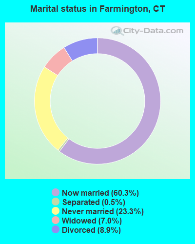
- Never married: 23.3%
- Now married: 60.3%
- Separated: 0.5%
- Widowed: 7.0%
- Divorced: 8.9%
For population 25 years and over in Farmington:
- High school or higher: 91.6%
- Bachelor's degree or higher: 49.2%
- Graduate or professional degree: 22.2%
- Unemployed: 3.5%
- Mean travel time to work (commute): 23.4 minutes
| Here: | 11.8 |
| Connecticut average: | 12.8 |
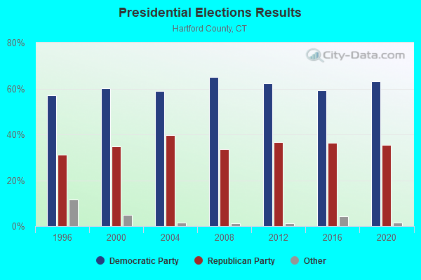
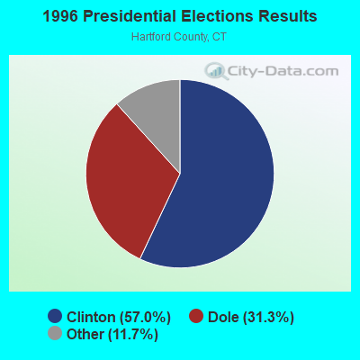
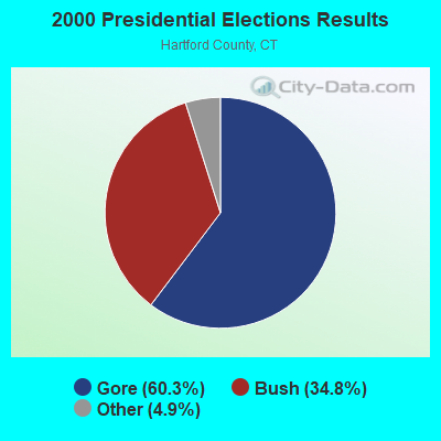
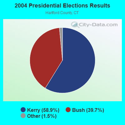
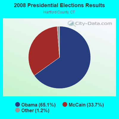
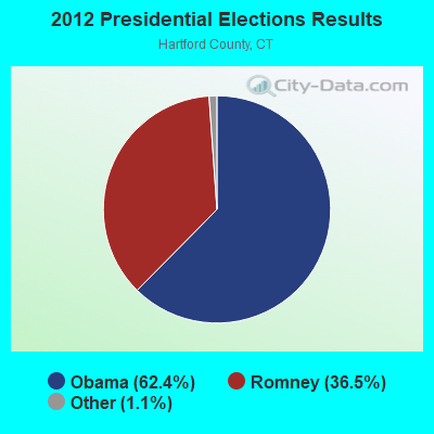
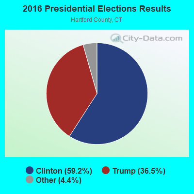
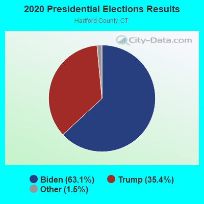
Graphs represent county-level data. Detailed 2008 Election Results
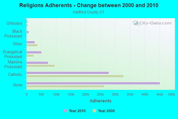
Religion statistics for Farmington, CT (based on Hartford County data)
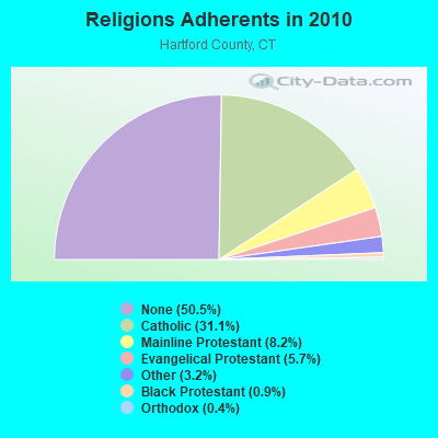
| Religion | Adherents | Congregations |
|---|---|---|
| Catholic | 278,203 | 100 |
| Mainline Protestant | 73,522 | 183 |
| Evangelical Protestant | 50,619 | 214 |
| Other | 28,183 | 94 |
| Black Protestant | 8,446 | 26 |
| Orthodox | 3,665 | 13 |
| None | 451,376 | - |
Food Environment Statistics:
| Hartford County: | 2.46 / 10,000 pop. |
| State: | 2.21 / 10,000 pop. |
| This county: | 0.06 / 10,000 pop. |
| Connecticut: | 0.07 / 10,000 pop. |
| Here: | 1.05 / 10,000 pop. |
| Connecticut: | 1.02 / 10,000 pop. |
| Here: | 2.32 / 10,000 pop. |
| Connecticut: | 2.27 / 10,000 pop. |
| This county: | 8.63 / 10,000 pop. |
| Connecticut: | 9.19 / 10,000 pop. |
| Hartford County: | 7.4% |
| Connecticut: | 7.3% |
| Hartford County: | 22.1% |
| Connecticut: | 21.5% |
| This county: | 16.0% |
| State: | 15.8% |
4.94% of this county's 2021 resident taxpayers lived in other counties in 2020 ($69,891 average adjusted gross income)
| Here: | 4.94% |
| Connecticut average: | 5.79% |
0.04% of residents moved from foreign countries ($102 average AGI)
Hartford County: 0.04% Connecticut average: 0.02%
Top counties from which taxpayers relocated into this county between 2020 and 2021:
| from New Haven County, CT | |
| from Tolland County, CT | |
| from Middlesex County, CT |
5.15% of this county's 2020 resident taxpayers moved to other counties in 2021 ($92,529 average adjusted gross income)
| Here: | 5.15% |
| Connecticut average: | 5.82% |
0.03% of residents moved to foreign countries ($235 average AGI)
Hartford County: 0.03% Connecticut average: 0.02%
Top counties to which taxpayers relocated from this county between 2020 and 2021:
| to Tolland County, CT | |
| to New Haven County, CT | |
| to Middlesex County, CT |
| Businesses in Farmington, CT | ||||
| Name | Count | Name | Count | |
|---|---|---|---|---|
| AT&T | 1 | J. Jill | 1 | |
| Abercrombie & Fitch | 1 | J.Crew | 1 | |
| Abercrombie Kids | 1 | JCPenney | 1 | |
| Aeropostale | 2 | Jones New York | 4 | |
| American Eagle Outfitters | 3 | Justice | 1 | |
| Ann Taylor | 2 | Lane Furniture | 1 | |
| Apple Store | 1 | LensCrafters | 1 | |
| Bakers | 1 | Macy's | 1 | |
| Banana Republic | 1 | Marriott | 2 | |
| Barnes & Noble | 1 | McDonald's | 1 | |
| Bath & Body Works | 1 | Motherhood Maternity | 2 | |
| Bebe | 1 | New Balance | 2 | |
| Bed Bath & Beyond | 1 | Nike | 11 | |
| Brooks Brothers | 1 | Nordstrom | 1 | |
| Brookstone | 1 | Pac Sun | 1 | |
| Burger King | 1 | Pottery Barn | 1 | |
| CVS | 1 | RadioShack | 1 | |
| Cache | 1 | Ruby Tuesday | 1 | |
| Clarks | 1 | Sephora | 1 | |
| Dunkin Donuts | 6 | Sprint Nextel | 2 | |
| Express | 1 | Starbucks | 2 | |
| Extended Stay Deluxe | 1 | Subway | 3 | |
| FedEx | 19 | T-Mobile | 1 | |
| Foot Locker | 1 | T.J.Maxx | 1 | |
| Forever 21 | 1 | Talbots | 1 | |
| GNC | 1 | The Limited | 1 | |
| GameStop | 1 | UPS | 21 | |
| Gap | 3 | Urban Outfitters | 1 | |
| Gymboree | 1 | Vans | 1 | |
| H&M | 1 | Verizon Wireless | 2 | |
| Hilton | 2 | Victoria's Secret | 2 | |
| Hollister Co. | 1 | Wendy's | 1 | |
| Hot Topic | 1 | |||
Strongest AM radio stations in Farmington:
- WTIC (1080 AM; 50 kW; HARTFORD, CT; Owner: INFINITY RADIO OPERATIONS INC.)
- WLAT (910 AM; 5 kW; NEW BRITAIN, CT; Owner: MEGA COMMUNICATIONS OF NEW BRITAIN LICENSEE, LLC)
- WPOP (1410 AM; 5 kW; HARTFORD, CT; Owner: CAPSTAR TX LIMITED PARTNERSHIP)
- WNNZ (640 AM; 50 kW; WESTFIELD, MA; Owner: CLEAR CHANNEL BROADCASTING LICENSES, INC.)
- WDRC (1360 AM; 5 kW; HARTFORD, CT; Owner: BUCKLEY BROADCASTING CORPORATION)
- WDZK (1550 AM; 5 kW; BLOOMFIELD, CT; Owner: ABC, INC.)
- WRYM (840 AM; 1 kW; NEW BRITAIN, CT)
- WXCT (990 AM; 2 kW; SOUTHINGTON, CT; Owner: THE ADD RADIO GROUP, INC.)
- WTMI (1290 AM; 1 kW; WEST HARTFORD, CT; Owner: MARLIN BROADCASTING, LLC)
- WPRX (1120 AM; 1 kW; BRISTOL, CT; Owner: NIEVEZQUEZ PRODUCTIONS, INC)
- WCRN (830 AM; 50 kW; WORCESTER, MA; Owner: CARTER BROADCASTING CORPORATION)
- WATR (1320 AM; 5 kW; WATERBURY, CT; Owner: WATR, INC.)
- WSNG (610 AM; 1 kW; TORRINGTON, CT; Owner: BUCKLEY BROADCASTING CORPORATION OF)
Strongest FM radio stations in Farmington:
- WRCH (100.5 FM; NEW BRITAIN, CT; Owner: INFINITY RADIO OPERATIONS INC.)
- WTIC-FM (96.5 FM; HARTFORD, CT; Owner: INFINITY RADIO OPERATIONS INC.)
- WWUH (91.3 FM; WEST HARTFORD, CT; Owner: UNIVERSITY OF HARTFORD)
- WCCC-FM (106.9 FM; HARTFORD, CT; Owner: MARLIN BROADCASTING, LLC)
- WJMJ (88.9 FM; HARTFORD, CT; Owner: ST. THOMAS SEMINARY)
- WWYZ (92.5 FM; WATERBURY, CT; Owner: CAPSTAR TX LIMITED PARTNERSHIP)
- WKSS (95.7 FM; HARTFORD-MERIDEN, CT; Owner: CAPSTAR TX LIMITED PARTNERSHIP)
- WHCN (105.9 FM; HARTFORD, CT; Owner: CAPSTAR TX LIMITED PARTNERSHIP)
- WZMX (93.7 FM; HARTFORD, CT; Owner: INFINITY RADIO OPERATIONS INC.)
- WMRQ (104.1 FM; WATERBURY, CT; Owner: CAPSTAR TX LIMITED PARTNERSHIP)
- WPKT (90.5 FM; MERIDEN, CT; Owner: CONNECTICUT PUBLIC BROADCASTING, INC)
- WDRC-FM (102.9 FM; HARTFORD, CT; Owner: BUCKLEY BROADCASTING CORPORATION)
- WKCI-FM (101.3 FM; HAMDEN, CT; Owner: CLEAR CHANNEL BROADCASTING LICENSES, INC.)
- WPLR (99.1 FM; NEW HAVEN, CT; Owner: COX RADIO, INC.)
- WFCS (107.7 FM; NEW BRITAIN, CT; Owner: CENTRAL CONNECTICUT STATE UNIVERSITY)
- WAQY (102.1 FM; SPRINGFIELD, MA; Owner: SAGA COMMUNICATIONS OF NEW ENGLAND, LLC)
- W227AJ (93.3 FM; NORTHFORD, CT; Owner: SACRED HEART UNIVERSITY)
- WHYN-FM (93.1 FM; SPRINGFIELD, MA; Owner: CLEAR CHANNEL BROADCASTING LICENSES, INC.)
- WZBG (97.3 FM; LITCHFIELD, CT; Owner: LOCAL GIRLS & BOYS B/CASTING CORP.)
- WRNX (100.9 FM; AMHERST, MA; Owner: WESTERN MASSACHUSETTS RADIO COMPANY)
TV broadcast stations around Farmington:
- WTIC-TV (Channel 61; HARTFORD, CT; Owner: TRIBUNE TELEVISION COMPANY)
- W11BJ (Channel 11; HARTFORD, CT; Owner: COMMUNICATIONS SITE MANAGEMENT LLC)
- WTXX (Channel 20; WATERBURY, CT; Owner: WTXX INC.)
- WVIT (Channel 30; NEW BRITAIN, CT; Owner: OUTLET BROADCASTING, INC)
- WEDH (Channel 24; HARTFORD, CT; Owner: CONNECTICUT PUBLIC BROADCASTING, INC.)
- WUVN (Channel 18; HARTFORD, CT; Owner: ENTRAVISION HOLDINGS, LLC)
- WFSB (Channel 3; HARTFORD, CT; Owner: MEREDITH CORPORATION)
- WHCT-LP (Channel 38; HARTFORD, CT; Owner: VENTURE TECHNOLOGIES GROUP, LLC)
- WUTH-CA (Channel 47; HARTFORD, CT; Owner: ENTRAVISION HOLDINGS, LLC)
- WHTX-LP (Channel 10; HARTFORD, CT; Owner: ENTRAVISION HOLDINGS, LLC)
- WRDM-LP (Channel 13; HARTFORD, CT; Owner: ZGS HARTFORD, INC.)
- WMLD-LP (Channel 6; HARTFORD, CT; Owner: HARVARD BROADCASTING, INC.)
- WTNH (Channel 8; NEW HAVEN, CT; Owner: WTNH BROADCASTING, INC.)
- WCTX (Channel 59; NEW HAVEN, CT; Owner: WTNH BROADCASTING, INC.)
- WEDY (Channel 65; NEW HAVEN, CT; Owner: CONNECTICUT PUBLIC BROADCASTING, INC.)
- WHPX (Channel 26; NEW LONDON, CT; Owner: PAXSON HARTFORD LICENSE, INC.)
- WYDN (Channel 48; WORCESTER, MA; Owner: EDUCATIONAL PUBLIC TV CORPORATION)
- WWLP (Channel 22; SPRINGFIELD, MA; Owner: WWLP BROADCASTING, LLC)
- W51BZ (Channel 51; NEW HAVEN, CT; Owner: it COMMUNICATIONS, INC.)
- W12BH (Channel 12; WATERBURY, CT; Owner: CONN.PUBLIC BROADCASTING, INC.)
- National Bridge Inventory (NBI) Statistics
- 67Number of bridges
- 850ft / 259mTotal length
- $3,915,000Total costs
- 1,492,859Total average daily traffic
- 135,900Total average daily truck traffic
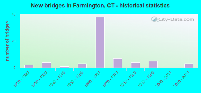
- New bridges - historical statistics
- 21920-1929
- 41930-1939
- 11940-1949
- 31950-1959
- 381960-1969
- 71970-1979
- 41980-1989
- 51990-1999
- 32010-2019
FCC Registered Commercial Land Mobile Towers: 7 (See the full list of FCC Registered Commercial Land Mobile Towers in Farmington, CT)
FCC Registered Private Land Mobile Towers: 3 (See the full list of FCC Registered Private Land Mobile Towers)
FCC Registered Broadcast Land Mobile Towers: 42 (See the full list of FCC Registered Broadcast Land Mobile Towers)
FCC Registered Microwave Towers: 54 (See the full list of FCC Registered Microwave Towers in this town)
FCC Registered Paging Towers: 9 (See the full list of FCC Registered Paging Towers)
FCC Registered Maritime Coast & Aviation Ground Towers: 1 (See the full list of FCC Registered Maritime Coast & Aviation Ground Towers)
FCC Registered Amateur Radio Licenses: 109 (See the full list of FCC Registered Amateur Radio Licenses in Farmington)
FAA Registered Aircraft Manufacturers and Dealers: 3 (See the full list of FAA Registered Manufacturers and Dealers in Farmington)
FAA Registered Aircraft: 10 (See the full list of FAA Registered Aircraft)
2002 - 2018 National Fire Incident Reporting System (NFIRS) incidents
- Fire incident types reported to NFIRS in Farmington, CT
- 60443.4%Structure Fires
- 43030.9%Outside Fires
- 28120.2%Mobile Property/Vehicle Fires
- 785.6%Other
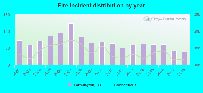 Based on the data from the years 2002 - 2018 the average number of fire incidents per year is 82. The highest number of reported fires - 148 took place in 2007, and the least - 46 in 2018. The data has a dropping trend.
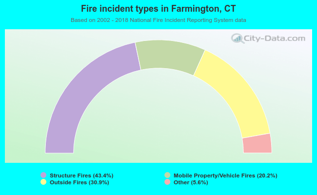 When looking into fire subcategories, the most incidents belonged to: Structure Fires (43.4%), and Outside Fires (30.9%).
Fire-safe hotels and motels in Farmington, Connecticut:
- Centennial Inn Suites, 5 Spring Ln, Farmington, Connecticut 06032 , Phone: (860) 677-4647, Fax: (860) 674-8487
- Extended Stay America - Hartford - Farmington, 1 Batterson Park Rd, Farmington, Connecticut 06032 , Phone: (860) 676-2790, Fax: (860) 676-2793
- Hampton Inn & Suites, 301 Colt Hwy, Farmington, Connecticut 06032 , Phone: (860) 674-8488, Fax: (860) 674-8478
| Most common first names in Farmington, CT among deceased individuals | ||
| Name | Count | Lived (average) |
|---|---|---|
| Mary | 139 | 84.6 years |
| John | 129 | 77.2 years |
| William | 99 | 76.5 years |
| Joseph | 93 | 81.3 years |
| Robert | 81 | 76.0 years |
| Helen | 79 | 82.7 years |
| Anna | 64 | 84.9 years |
| George | 63 | 79.0 years |
| Elizabeth | 60 | 79.9 years |
| Margaret | 58 | 84.0 years |
| Most common last names in Farmington, CT among deceased individuals | ||
| Last name | Count | Lived (average) |
|---|---|---|
| Smith | 33 | 83.6 years |
| Johnson | 27 | 83.7 years |
| Anderson | 17 | 80.1 years |
| Brown | 15 | 86.4 years |
| Thompson | 15 | 82.7 years |
| Jones | 12 | 80.5 years |
| Lewis | 12 | 81.2 years |
| Martin | 12 | 80.2 years |
| White | 12 | 86.7 years |
| Clark | 10 | 83.4 years |
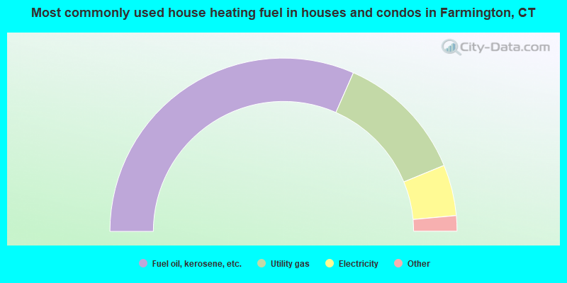
- 63.2%Fuel oil, kerosene, etc.
- 24.4%Utility gas
- 9.5%Electricity
- 2.5%Bottled, tank, or LP gas
- 0.2%Wood
- 0.1%Other fuel
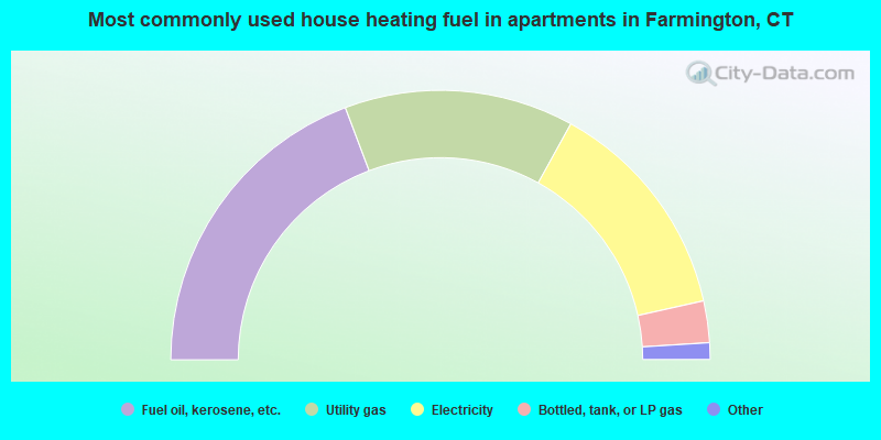
- 38.5%Fuel oil, kerosene, etc.
- 27.5%Utility gas
- 26.9%Electricity
- 5.0%Bottled, tank, or LP gas
- 1.7%Other fuel
- 0.3%No fuel used
Farmington compared to Connecticut state average:
- Unemployed percentage significantly below state average.
- Black race population percentage significantly below state average.
- Hispanic race population percentage significantly below state average.
- Median age above state average.
- Length of stay since moving in significantly above state average.
- Number of rooms per house significantly below state average.
- House age significantly below state average.
- Percentage of population with a bachelor's degree or higher above state average.
Farmington on our top lists:
- #21 on the list of "Top 101 cities with largest percentage of males in occupations: physicians and surgeons (population 5,000+)"
- #36 on the list of "Top 101 cities with largest percentage of females in occupations: physicians and surgeons (population 5,000+)"
- #38 on the list of "Top 101 cities with largest percentage of males in occupations: lawyers (population 5,000+)"
- #38 on the list of "Top 101 cities with largest percentage of males in industries: health care (population 5,000+)"
- #42 on the list of "Top 101 cities with largest percentage of females in occupations: lawyers (population 5,000+)"
- #44 on the list of "Top 101 cities with largest percentage of females in occupations: mathematical science occupations (population 5,000+)"
- #51 on the list of "Top 101 cities with largest percentage of males in occupations: other health diagnosing and treating practitioners and technical occupations (population 5,000+)"
- #68 on the list of "Top 101 cities with largest percentage of females in industries: finance and insurance (population 5,000+)"
- #88 on the list of "Top 101 cities with largest percentage of males in industries: jewelry, luggage, and leather goods stores (population 5,000+)"
- #98 on the list of "Top 101 cities with largest percentage of females in industries: metal and metal products (population 5,000+)"
- #2 on the list of "Top 101 counties with highest percentage of residents voting for Obama (Democrat) in the 2012 Presidential Election"
- #17 on the list of "Top 101 counties with the most Catholic congregations"
- #19 on the list of "Top 101 counties with the lowest Particulate Matter (PM10) Annual air pollution readings in 2012 (µg/m3)"
- #24 on the list of "Top 101 counties with the highest percentage of residents that visited a dentist within the past year"
- #29 on the list of "Top 101 counties with the most Mainline Protestant congregations"

|
|
Total of 612 patent applications in 2008-2024.