East Rutherford, Pennsylvania
Submit your own pictures of this place and show them to the world
- OSM Map
- General Map
- Google Map
- MSN Map

Population change since 2000: +5.9%
| Males: 128 | |
| Females: 68 |
| Median resident age: | 53.3 years |
| Pennsylvania median age: | 40.9 years |
| East Rutherford: | $49,609 |
| PA: | $71,798 |
Estimated per capita income in 2022: $26,212 (it was $13,456 in 2000)
Estimated median house or condo value in 2022: $149,754 (it was $64,500 in 2000)
| East Rutherford: | $149,754 |
| PA: | $245,500 |
Mean prices in 2022: all housing units: $97,292; detached houses: $97,486
Median gross rent in 2022: $1,476.
East Rutherford, PA residents, houses, and apartments details
Detailed information about poverty and poor residents in East Rutherford, PA
Compare current foreclosures near East Rutherford, PA:
| Photo | Address | Area | Beds / Baths | Price | Details |
|---|---|---|---|---|---|

|
#1
Amberson Rd
Spring Run, PA 17262
|
1,208 sq. feet
|
1 baths 3 beds |
$150,000
|
show details |

|
#2
Bridgeport Rd
Landisburg, PA 17040
|
1,428 sq. feet
|
2 baths 5 beds |
show details | |

|
#3
E Walnut St
Lewistown, PA 17044
|
1,495 sq. feet
|
3 baths 3 beds |
show details | |

|
#4
Miller Ln
Granville, PA 17029
|
1,128 sq. feet
|
1 baths 3 beds |
show details | |

|
#5
N Harmon Rd
Newburg, PA 17240
|
1,264 sq. feet
|
2 baths 4 beds |
show details | |

|
#6
W 6th St
Lewistown, PA 17044
|
1,044 sq. feet
|
1 baths 3 beds |
show details | |

|
#7
Big Spring Rd
Blain, PA 17006
|
1,944 sq. feet
|
- baths - beds |
show details | |

|
#8
Pannebaker Ave
Lewistown, PA 17044
|
1,152 sq. feet
|
- baths - beds |
show details | |

|
#9
S Main St
Lewistown, PA 17044
|
1,272 sq. feet
|
- baths - beds |
show details | |

|
#10
Country View Est # 15
Newville, PA 17241
|
- sq. feet
|
- baths - beds |
show details |
| Photo | Address | Area | Beds / Baths | Price | Details |
|---|---|---|---|---|---|

|
#11
Bob Cat Rd
Newville, PA 17241
|
2,466 sq. feet
|
- baths - beds |
show details | |

|
#12
S Spruce St
Lewistown, PA 17044
|
- sq. feet
|
- baths - beds |
show details | |

|
#13
Minick Dr
Newburg, PA 17240
|
- sq. feet
|
- baths - beds |
show details | |

|
#14
Gilbo Rd
Shirleysburg, PA 17260
|
- sq. feet
|
- baths - beds |
show details | |

|
#15
Lynn Ave
Newburg, PA 17240
|
1,774 sq. feet
|
- baths - beds |
show details | |

|
#16
Lynn Ave
Newburg, PA 17240
|
1,774 sq. feet
|
- baths - beds |
show details | |

|
#17
E Walnut St
Lewistown, PA 17044
|
1,344 sq. feet
|
- baths - beds |
show details | |

|
#18
Spanogle Ave
Lewistown, PA 17044
|
1,456 sq. feet
|
- baths - beds |
show details | |

|
#19
E Walnut St
Lewistown, PA 17044
|
1,440 sq. feet
|
- baths - beds |
show details | |

|
#20
Waggoners Gap Rd
Landisburg, PA 17040
|
- sq. feet
|
- baths - beds |
show details |
| Photo | Address | Area | Beds / Baths | Price | Details |
|---|---|---|---|---|---|

|
#21
Back Hollow Rd
Blain, PA 17006
|
1,424 sq. feet
|
- baths - beds |
show details | |

|
#22
Hunters Rd
Newville, PA 17241
|
1,104 sq. feet
|
- baths - beds |
show details | |

|
#23
S Wayne St
Lewistown, PA 17044
|
1,556 sq. feet
|
- baths - beds |
show details | |

|
#24
Nolan Rd
Mount Union, PA 17066
|
1,404 sq. feet
|
- baths - beds |
show details | |

|
#25
Wisteria Ln
Mc Veytown, PA 17051
|
1,904 sq. feet
|
- baths - beds |
show details | |

|
#26
Woodhaven Dr
Lewistown, PA 17044
|
- sq. feet
|
- baths - beds |
show details | |

|
#27
Hidden Valley Rd
Loysville, PA 17047
|
1,368 sq. feet
|
- baths - beds |
show details | |

|
#28
Caldwell Hill Rd
Lewistown, PA 17044
|
1,484 sq. feet
|
- baths - beds |
show details | |

|
#29
Center Rd
Newville, PA 17241
|
1,056 sq. feet
|
- baths - beds |
show details | |

|
#30
Us Highway 522 S
Lewistown, PA 17044
|
- sq. feet
|
- baths - beds |
show details |
| Photo | Address | Area | Beds / Baths | Price | Details |
|---|---|---|---|---|---|

|
#31
Country Ln
Mc Veytown, PA 17051
|
1,536 sq. feet
|
- baths - beds |
show details | |

|
#32
Alexander Ave
Mount Union, PA 17066
|
- sq. feet
|
- baths - beds |
show details | |

|
#33
Liverpool St
Mount Union, PA 17066
|
- sq. feet
|
- baths - beds |
show details | |

|
#34
W Pennsylvania Ave
Mount Union, PA 17066
|
- sq. feet
|
- baths - beds |
show details | |

|
#35
E Walnut St
Lewistown, PA 17044
|
1,192 sq. feet
|
- baths - beds |
show details | |

|
#36
Route 75 S
Port Royal, PA 17082
|
- sq. feet
|
- baths - beds |
show details | |

|
#37
E Main St
Newburg, PA 17240
|
- sq. feet
|
- baths - beds |
show details | |

|
#38
Knepp Ave
Lewistown, PA 17044
|
- sq. feet
|
- baths - beds |
show details | |

|
#39
Cottage Rd
Mifflin, PA 17058
|
- sq. feet
|
- baths - beds |
show details | |

|
#40
Groninger Valley Rd
Port Royal, PA 17082
|
- sq. feet
|
- baths - beds |
show details |
| Photo | Address | Area | Beds / Baths | Price | Details |
|---|---|---|---|---|---|

|
#41
Peachy Ann Dr
Newville, PA 17241
|
- sq. feet
|
- baths - beds |
show details | |

|
#42
Country View Est
Newville, PA 17241
|
- sq. feet
|
- baths - beds |
show details | |

|
#43
Us Highway 522 S
Mc Veytown, PA 17051
|
- sq. feet
|
- baths - beds |
show details | |

|
#44
Adele Ave
Carlisle, PA 17015
|
- sq. feet
|
- baths - beds |
show details | |

|
#45
Big Spring Rd
Doylesburg, PA 17219
|
- sq. feet
|
- baths - beds |
show details | |

|
Check over 1 million property listings on Foreclosure.com!
|
browse all offers | |||
 Recent articles from our blog. Our writers, many of them Ph.D. graduates or candidates, create easy-to-read articles on a wide variety of topics.

 | The 76ers Center City Arena Will Dramatically Kill Center City! (161 replies) |
| Eagles 2018/19 (110 replies) |
| Pittsburgh: Football and hockey town (74 replies) |
| South Philly: Pathetic... Brutal Beating After NHL Hockey Game (91 replies) |
| cheap fruit and veggie store near scranton? (19 replies) |
| Is Lehigh Valley All Philly or Some NY Fan Territory? (4 replies) |
Latest news from East Rutherford, PA collected exclusively by city-data.com from local newspapers, TV, and radio stations
Ancestries: German (64.1%), English (18.9%), Irish (9.4%), American (7.5%).
Current Local Time: EST time zone
Elevation: 620 feet
Land area: 0.23 square miles.
Population density: 860 people per square mile (low).

| East Rutherford CDP: | 0.7% ($442) |
| Pennsylvania: | 1.6% ($1,552) |
Nearest city with pop. 50,000+: Frederick, MD  (66.0 miles , pop. 52,767).
Nearest city with pop. 200,000+: Baltimore, MD (90.3 miles , pop. 651,154).
Nearest city with pop. 1,000,000+: Philadelphia, PA (132.5 miles , pop. 1,517,550).
Nearest cities:
), ), ), ), )Latitude: 40.37 N, Longitude: 77.60 W
Area code commonly used in this area: 717


| Here: | 3.3% |
| Pennsylvania: | 2.9% |

- Wood products (10.9%)
- Truck transportation (10.9%)
- Accommodation & food services (10.9%)
- Finance & insurance (9.8%)
- Construction (5.4%)
- Public administration (5.4%)
- Agriculture, forestry, fishing & hunting (4.3%)

- Wood products (17.5%)
- Construction (8.8%)
- Agriculture, forestry, fishing & hunting (7.0%)
- Transportation equipment (7.0%)
- Plastics & rubber products (7.0%)
- Furniture & related product manufacturing (7.0%)
- Truck transportation (7.0%)

- Accommodation & food services (22.9%)
- Truck transportation (17.1%)
- Finance & insurance (17.1%)
- Public administration (14.3%)
- Food (11.4%)
- Apparel (5.7%)
- Arts, entertainment, recreation (5.7%)

- Other production occupations, including supervisors (10.9%)
- Information and record clerks, except customer service representatives (7.6%)
- Other material moving workers, except laborers (7.6%)
- Woodworkers (6.5%)
- Waiters and waitresses (6.5%)
- Secretaries and administrative assistants (6.5%)
- Textile, apparel, and furnishings workers (6.5%)

- Other production occupations, including supervisors (17.5%)
- Other material moving workers, except laborers (12.3%)
- Woodworkers (10.5%)
- Agricultural workers, including supervisors (7.0%)
- Textile, apparel, and furnishings workers (7.0%)
- Driver/sales workers and truck drivers (7.0%)
- Top executives (5.3%)

- Information and record clerks, except customer service representatives (20.0%)
- Waiters and waitresses (17.1%)
- Secretaries and administrative assistants (17.1%)
- Computer specialists (8.6%)
- Material recording, scheduling, dispatching, and distributing workers (8.6%)
- Food processing workers (5.7%)
- Textile, apparel, and furnishings workers (5.7%)
Average climate in East Rutherford, Pennsylvania
Based on data reported by over 4,000 weather stations


(lower is better)

Air Quality Index (AQI) level in 2023 was 103. This is significantly worse than average.
| City: | 103 |
| U.S.: | 73 |

Nitrogen Dioxide (NO2) [ppb] level in 2013 was 2.78. This is significantly better than average. Closest monitor was 23.9 miles away from the city center.
| City: | 2.78 |
| U.S.: | 5.11 |

Sulfur Dioxide (SO2) [ppb] level in 2014 was 0.468. This is significantly better than average. Closest monitor was 23.9 miles away from the city center.
| City: | 0.468 |
| U.S.: | 1.515 |

Ozone [ppb] level in 2014 was 27.1. This is better than average. Closest monitor was 23.9 miles away from the city center.
| City: | 27.1 |
| U.S.: | 33.3 |

Particulate Matter (PM2.5) [µg/m3] level in 2023 was 14.2. This is significantly worse than average. Closest monitor was 23.6 miles away from the city center.
| City: | 14.2 |
| U.S.: | 8.1 |
Tornado activity:
East Rutherford-area historical tornado activity is slightly below Pennsylvania state average. It is 25% smaller than the overall U.S. average.
On 4/16/1961, a category F3 (max. wind speeds 158-206 mph) tornado 22.6 miles away from the East Rutherford place center caused between $50,000 and $500,000 in damages.
On 6/20/1989, a category F2 (max. wind speeds 113-157 mph) tornado 5.5 miles away from the place center injured one person and caused between $5000 and $50,000 in damages.
Earthquake activity:
East Rutherford-area historical earthquake activity is significantly above Pennsylvania state average. It is 62% smaller than the overall U.S. average.On 8/23/2011 at 17:51:04, a magnitude 5.8 (5.8 MW, Depth: 3.7 mi, Class: Moderate, Intensity: VI - VII) earthquake occurred 171.1 miles away from the city center
On 9/25/1998 at 19:52:52, a magnitude 5.2 (4.8 MB, 4.3 MS, 5.2 LG, 4.5 MW, Depth: 3.1 mi) earthquake occurred 165.2 miles away from East Rutherford center
On 1/16/1994 at 01:49:16, a magnitude 4.6 (4.6 MB, 4.6 LG, Depth: 3.1 mi, Class: Light, Intensity: IV - V) earthquake occurred 82.7 miles away from East Rutherford center
On 1/31/1986 at 16:46:43, a magnitude 5.0 (5.0 MB) earthquake occurred 204.2 miles away from East Rutherford center
On 1/16/1994 at 00:42:43, a magnitude 4.2 (4.2 MB, 4.0 LG, Depth: 3.1 mi) earthquake occurred 84.2 miles away from East Rutherford center
On 10/7/1983 at 10:18:46, a magnitude 5.3 (5.1 MB, 5.3 LG, 5.1 ML) earthquake occurred 298.9 miles away from East Rutherford center
Magnitude types: regional Lg-wave magnitude (LG), body-wave magnitude (MB), local magnitude (ML), surface-wave magnitude (MS), moment magnitude (MW)
Natural disasters:
The number of natural disasters in Juniata County (18) is near the US average (15).Major Disasters (Presidential) Declared: 14
Emergencies Declared: 4
Causes of natural disasters: Floods: 4, Hurricanes: 4, Snowstorms: 3, Storms: 3, Tropical Storms: 3, Winter Storms: 3, Blizzard: 1, Heavy Rain: 1, Snowfall: 1, Tropical Depression: 1, Other: 1 (Note: some incidents may be assigned to more than one category).
Colleges/universities with over 2000 students nearest to East Rutherford:
- Shippensburg University of Pennsylvania (about 23 miles; Shippensburg, PA; Full-time enrollment: 7,051)
- Dickinson College (about 25 miles; Carlisle, PA; FT enrollment: 2,505)
- Pennsylvania State University-Main Campus (about 33 miles; University Park, PA; FT enrollment: 45,483)
- Pennsylvania State University-World Campus (about 35 miles; University Park, PA; FT enrollment: 4,893)
- Messiah College (about 36 miles; Mechanicsburg, PA; FT enrollment: 3,035)
- Harrisburg Area Community College-Harrisburg (about 39 miles; Harrisburg, PA; FT enrollment: 13,276)
- Gettysburg College (about 42 miles; Gettysburg, PA; FT enrollment: 2,772)
Points of interest:
Notable location: East Waterford Community Fire Company (A). Display/hide its location on the map
Streams, rivers, and creeks: Horse Valley Run (A). Display/hide its location on the map
| This place: | 2.5 people |
| Pennsylvania: | 2.5 people |
| This place: | 67.5% |
| Whole state: | 65.0% |
| This place: | 12.5% |
| Whole state: | 6.6% |
No gay or lesbian households reported
For population 15 years and over in East Rutherford:

- Never married: 16.1%
- Now married: 33.0%
- Separated: 0.0%
- Widowed: 15.4%
- Divorced: 35.6%
For population 25 years and over in East Rutherford:
- High school or higher: 81.1%
- Bachelor's degree or higher: 0.0%
- Graduate or professional degree: 0.0%
- Mean travel time to work (commute): 43.1 minutes


| Here: | 2.4 |
| Pennsylvania average: | 11.4 |
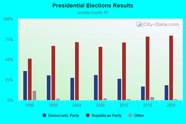
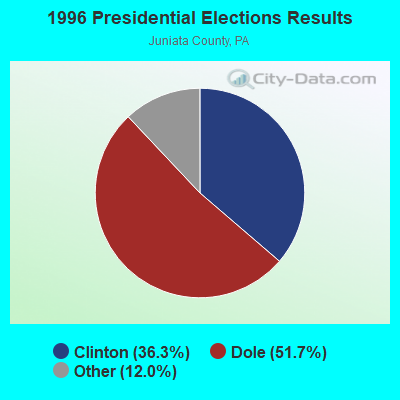


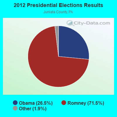


Graphs represent county-level data. Detailed 2008 Election Results
Religion statistics for East Rutherford, PA (based on Juniata County data)
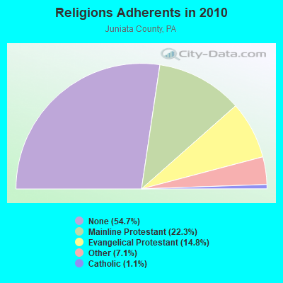
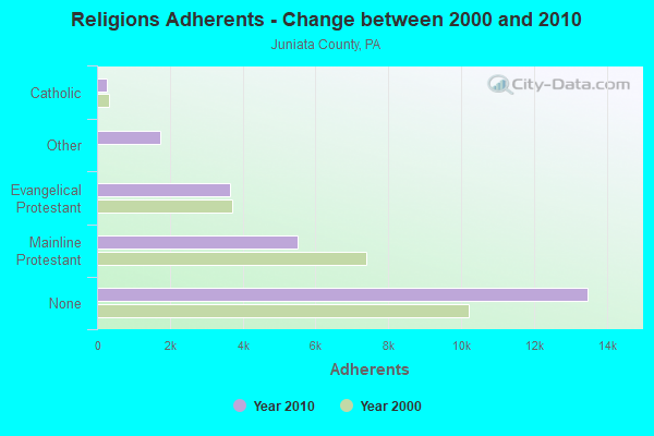
| Religion | Adherents | Congregations |
|---|---|---|
| Mainline Protestant | 5,497 | 33 |
| Evangelical Protestant | 3,645 | 31 |
| Other | 1,747 | 3 |
| Catholic | 264 | 1 |
| None | 13,483 | - |
Food Environment Statistics:
| Juniata County: | 2.17 / 10,000 pop. |
| Pennsylvania: | 2.04 / 10,000 pop. |
| Here: | 1.30 / 10,000 pop. |
| Pennsylvania: | 0.88 / 10,000 pop. |
| Juniata County: | 4.76 / 10,000 pop. |
| Pennsylvania: | 2.52 / 10,000 pop. |
| This county: | 6.50 / 10,000 pop. |
| Pennsylvania: | 7.12 / 10,000 pop. |
| Juniata County: | 9.4% |
| Pennsylvania: | 9.1% |
| Juniata County: | 29.4% |
| Pennsylvania: | 27.2% |
| Juniata County: | 13.6% |
| State: | 11.5% |
Strongest AM radio stations in East Rutherford:
- WIEZ (670 AM; daytime; 5 kW; LEWISTOWN, PA; Owner: FIRST MEDIA RADIO, LLC)
- WCBM (680 AM; 50 kW; BALTIMORE, MD; Owner: WCBM MARYLAND, INC.)
- WHUN (1150 AM; 5 kW; HUNTINGDON, PA; Owner: MEGAHERTZ LICENSES, LLC)
- WHYL (960 AM; 5 kW; CARLISLE, PA; Owner: CITADEL BROADCASTING COMPANY)
- WBAL (1090 AM; 50 kW; BALTIMORE, MD; Owner: HEARST RADIO, INC.)
- WHP (580 AM; 5 kW; HARRISBURG, PA; Owner: CLEAR CHANNEL BROADCASTING LICENSES, INC.)
- WMET (1150 AM; 50 kW; GAITHERSBURG, MD; Owner: BELTWAY ACQUISITION CORPORATION)
- WGOP (700 AM; daytime; 25 kW; WALKERSVILLE, MD; Owner: BIRACH BROADCASTING CORPORATION)
- WKVA (920 AM; 1 kW; LEWISTOWN, PA; Owner: WVNW, INC.)
- WTEM (980 AM; 50 kW; WASHINGTON, DC; Owner: AMFM RADIO LICENSES, L.L.C.)
- WWJZ (640 AM; 50 kW; MOUNT HOLLY, NJ; Owner: ABC, INC.)
- WVCH (740 AM; 50 kW; CHESTER, PA; Owner: WVCH COMMUNICATIONS, INC.)
- WZSK (1040 AM; daytime; 10 kW; EVERETT, PA; Owner: NEW MILLENNIUM COMMUNICATIONS GROUP, INC.)
Strongest FM radio stations in East Rutherford:
- WJUN-FM (92.5 FM; MEXICO, PA; Owner: STARVIEW MEDIA, INC.)
- WQJU (107.1 FM; MIFFLINTOWN, PA; Owner: CENTRAL PA CHRISTIAN INSTITUTE, INC.)
- WXMJ (99.5 FM; MOUNT UNION, PA; Owner: MEGAHERTZ LICENSES, LLC)
- WJRC (90.9 FM; LEWISTOWN, PA; Owner: SALT AND LIGHT MEDIA MINISTRIES, INC)
- WVNW (96.7 FM; BURNHAM, PA; Owner: WVNW, INC.)
- WLAK (103.5 FM; HUNTINGDON, PA; Owner: FIRST MEDIA RADIO, LLC)
- WBUS (93.7 FM; BOALSBURG, PA; Owner: DAME BROADCASTING, LLC)
- WCHX (105.5 FM; LEWISTOWN, PA; Owner: MIFFLIN COUNTY COMMUNICATIONS, INC.)
- WLZS (106.1 FM; BEAVER SPRINGS, PA; Owner: STARVIEW MEDIA, INC)
- WEEO-FM (103.7 FM; MCCONNELLSBURG, PA; Owner: ALLEGHENY MOUNTAIN NETWORK)
- WBHV (103.1 FM; STATE COLLEGE, PA; Owner: FOREVER BROADCASTING, LLC)
- WWLY (106.3 FM; HUNTINGDON, PA; Owner: MEGAHERTZ LICENSES,LLC)
- WQLV (98.9 FM; MILLERSBURG, PA; Owner: HEPCO COMMUNICATIONS, INC.)
- WITF-FM (89.5 FM; HARRISBURG, PA; Owner: WITF, INC.)
- WMAJ-FM (104.9 FM; HOLLIDAYSBURG, PA; Owner: FOREVER OF PA, LLC)
- W270AG (101.9 FM; STATE COLLEGE, PA; Owner: SALT & LIGHT MEDIA MINISTRIES, INC.)
- W294AE (106.7 FM; ALTOONA, PA; Owner: THE PENNSYLVANIA STATE UNIVERSITY)
- WMRF-FM (95.7 FM; LEWISTOWN, PA; Owner: FIRST MEDIA RADIO, LLC)
- WJHT (107.9 FM; PORT MATILDA, PA; Owner: DAME BROADCASTING, LLC)
- W267AC (101.3 FM; ALTOONA, PA; Owner: ALLEGHENY MOUNTAIN NETWORK)
TV broadcast stations around East Rutherford:
- W12CA (Channel 12; ELLIOTTSBURG, PA; Owner: HEIRLOOM MINISTRIES, INC.)
East Rutherford fatal accident list:
- National Bridge Inventory (NBI) Statistics
- 1Number of bridges
- 3ft / 1.0mTotal length
- 673Total average daily traffic
- 114Total average daily truck traffic
- 943Total future (year 2037) average daily traffic
FCC Registered Microwave Towers:
1- PERULACK, Approx. 3 Miles Wsw Of (Lat: 40.353333 Lon: -77.657222), Type: Tower, Structure height: 36.6 m, Call Sign: WQLQ216,
Assigned Frequencies: 6093.45 MHz, Grant Date: 01/09/2020, Expiration Date: 03/26/2030, Certifier: D J Bolton, Registrant: Fcc-Faa Licensing, LLC, 8932 Suite D Milford Haven Court, Lorton, VA 22199, Phone: (703) 615-6615, Fax: (703) 372-5176, Email:

- 44.4%Bottled, tank, or LP gas
- 33.3%Fuel oil, kerosene, etc.
- 22.2%Electricity

- 52.0%Fuel oil, kerosene, etc.
- 48.0%Electricity
East Rutherford compared to Pennsylvania state average:
- Median house value significantly below state average.
- Unemployed percentage significantly below state average.
- Black race population percentage significantly below state average.
- Hispanic race population percentage significantly below state average.
- Median age below state average.
- Foreign-born population percentage significantly below state average.
- Length of stay since moving in significantly above state average.
- House age above state average.
- Number of college students significantly below state average.
- Percentage of population with a bachelor's degree or higher significantly below state average.