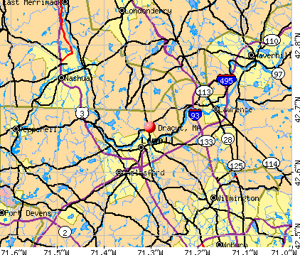
Dracut, Massachusetts
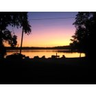
Dracut: Mascuppic lake at twilight - dracut ma
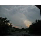
Dracut: June 2, 2011 - the day of the crazy tornados - clouds over Back to the Boathouse, Dracut Ma
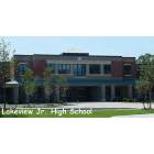
Dracut: Lakeview Junior High School
- add
your


Submit your own pictures of this town and show them to the world
- OSM Map
- General Map
- Google Map
- MSN Map
Population change since 2000: +3.1%
 |
| Males: 14,430 | |
| Females: 15,027 |
| Median resident age: | 39.9 years |
| Massachusetts median age: | 39.2 years |
Zip codes: 01826.
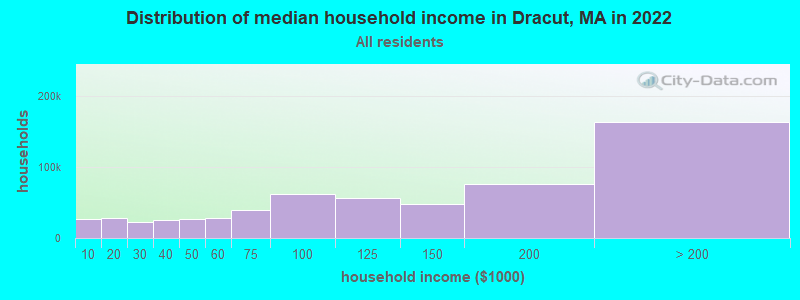
| Dracut: | $112,657 |
| MA: | $94,488 |
Estimated per capita income in 2022: $49,309 (it was $23,750 in 2000)
Dracut town income, earnings, and wages data
Estimated median house or condo value in 2022: $447,720 (it was $158,400 in 2000)
| Dracut: | $447,720 |
| MA: | $534,700 |
Mean prices in 2022: all housing units: $796,617; detached houses: $834,667; townhouses or other attached units: $772,440; in 2-unit structures: $786,250; in 3-to-4-unit structures: $655,835; in 5-or-more-unit structures: $590,321; mobile homes: $144,935
Detailed information about poverty and poor residents in Dracut, MA


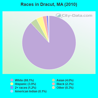
- 25,96588.1%White alone
- 1,1764.0%Asian alone
- 1,1493.9%Hispanic
- 6912.3%Black alone
- 3451.2%Two or more races
- 960.3%Other race alone
- 320.1%American Indian alone
- 30.01%Native Hawaiian and Other
Pacific Islander alone
Races in Dracut detailed stats: ancestries, foreign born residents, place of birth
According to our research of Massachusetts and other state lists, there were 10 registered sex offenders living in Dracut, Massachusetts as of May 08, 2024.
The ratio of all residents to sex offenders in Dracut is 2,946 to 1.
The ratio of registered sex offenders to all residents in this city is lower than the state average.
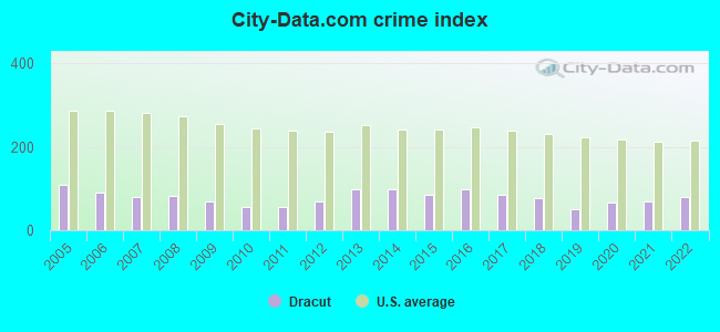
Type |
2009 |
2010 |
2011 |
2012 |
2013 |
2014 |
2015 |
2016 |
2017 |
2018 |
2019 |
2020 |
2021 |
2022 |
|---|---|---|---|---|---|---|---|---|---|---|---|---|---|---|
| Murders (per 100,000) | 0 (0.0) | 0 (0.0) | 0 (0.0) | 0 (0.0) | 0 (0.0) | 0 (0.0) | 0 (0.0) | 1 (3.2) | 0 (0.0) | 0 (0.0) | 0 (0.0) | 0 (0.0) | 0 (0.0) | 0 (0.0) |
| Rapes (per 100,000) | 4 (13.3) | 1 (3.4) | 1 (3.4) | 2 (6.7) | 4 (13.1) | 6 (19.3) | 4 (12.7) | 3 (9.5) | 4 (12.6) | 4 (12.5) | 2 (6.3) | 1 (3.2) | 6 (18.8) | 10 (31.3) |
| Robberies (per 100,000) | 9 (30.0) | 3 (10.2) | 11 (37.1) | 8 (26.6) | 8 (26.2) | 3 (9.7) | 1 (3.2) | 3 (9.5) | 4 (12.6) | 4 (12.5) | 4 (12.6) | 4 (12.6) | 3 (9.4) | 3 (9.4) |
| Assaults (per 100,000) | 11 (36.6) | 1 (3.4) | 1 (3.4) | 4 (13.3) | 8 (26.2) | 11 (35.4) | 15 (47.6) | 31 (98.1) | 33 (104.2) | 34 (106.5) | 24 (75.5) | 31 (97.8) | 49 (153.7) | 40 (125.4) |
| Burglaries (per 100,000) | 32 (106.5) | 26 (88.3) | 12 (40.5) | 77 (256.4) | 75 (245.6) | 69 (222.1) | 81 (257.3) | 64 (202.6) | 64 (202.0) | 48 (150.4) | 29 (91.2) | 23 (72.5) | 22 (69.0) | 21 (65.8) |
| Thefts (per 100,000) | 193 (642.3) | 269 (913.2) | 232 (782.8) | 212 (705.9) | 392 (1,284) | 395 (1,271) | 328 (1,042) | 316 (1,000) | 237 (748.0) | 208 (651.7) | 133 (418.4) | 215 (678.1) | 114 (357.6) | 154 (482.6) |
| Auto thefts (per 100,000) | 36 (119.8) | 20 (67.9) | 30 (101.2) | 22 (73.3) | 27 (88.4) | 21 (67.6) | 22 (69.9) | 24 (76.0) | 20 (63.1) | 21 (65.8) | 14 (44.0) | 34 (107.2) | 7 (22.0) | 13 (40.7) |
| Arson (per 100,000) | 0 (0.0) | 0 (0.0) | 0 (0.0) | 0 (0.0) | 0 (0.0) | 0 (0.0) | 1 (3.2) | 0 (0.0) | 0 (0.0) | 1 (3.1) | 1 (3.1) | 2 (6.3) | 4 (12.5) | 4 (12.5) |
| City-Data.com crime index | 69.7 | 54.6 | 56.8 | 68.0 | 99.2 | 97.2 | 85.9 | 96.7 | 83.8 | 76.9 | 50.6 | 66.6 | 69.5 | 80.1 |
The City-Data.com crime index weighs serious crimes and violent crimes more heavily. Higher means more crime, U.S. average is 246.1. It adjusts for the number of visitors and daily workers commuting into cities.
Crime rate in Dracut detailed stats: murders, rapes, robberies, assaults, burglaries, thefts, arson
Full-time law enforcement employees in 2021, including police officers: 46 (42 officers - 40 male; 2 female).
| Officers per 1,000 residents here: | 1.32 |
| Massachusetts average: | 2.53 |
 Recent articles from our blog. Our writers, many of them Ph.D. graduates or candidates, create easy-to-read articles on a wide variety of topics.


 | Haverhill teacher fired for inappropriate sex survey he gave in Dracut (1 reply) |
| 2021 Real Estate Observations (1729 replies) |
| Big MA Ancestry Data Thread by Town (31 replies) |
| Boston Racial Stigma- is it "cool" to hate on Boston? (632 replies) |
| These MA communities need to be avoided moving into:Dracut, Marshfield,Brewster (35 replies) |
| Buying a new house in Dracut, MA. (14 replies) |
Latest news from Dracut, MA collected exclusively by city-data.com from local newspapers, TV, and radio stations
Ancestries: Irish (29.1%), French (18.1%), French Canadian (15.8%), Italian (11.2%), English (10.0%), Polish (7.4%).
Current Local Time: EST time zone
Incorporated in 1701
Elevation: 156 feet
Land area: 20.9 square miles.
Population density: 1,410 people per square mile (low).
1,553 residents are foreign born (2.1% Asia, 1.5% Europe, 1.0% Latin America, 0.6% North America).
| This town: | 5.4% |
| Massachusetts: | 12.2% |
| Dracut town: | 1.4% ($2,218) |
| Massachusetts: | 1.3% ($2,336) |
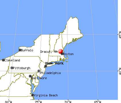
Nearest city with pop. 50,000+: Lowell, MA  (2.6 miles , pop. 105,167).
Nearest city with pop. 200,000+: Boston, MA (27.2 miles , pop. 589,141).
Nearest city with pop. 1,000,000+: Bronx, NY (182.9 miles , pop. 1,332,650).
Nearest cities:
), ), Latitude: 42.68 N, Longitude: 71.32 W

Dracut, Massachusetts accommodation & food services, waste management - Economy and Business Data
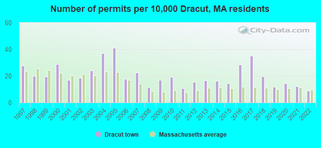
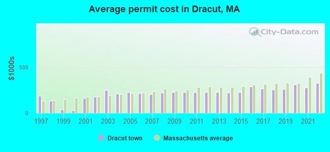
Single-family new house construction building permits:
- 2022: 25 buildings, average cost: $327,800
- 2021: 35 buildings, average cost: $273,600
- 2020: 41 buildings, average cost: $306,700
- 2019: 34 buildings, average cost: $261,500
- 2018: 56 buildings, average cost: $252,600
- 2017: 100 buildings, average cost: $263,900
- 2016: 81 buildings, average cost: $290,200
- 2015: 41 buildings, average cost: $225,000
- 2014: 47 buildings, average cost: $222,000
- 2013: 48 buildings, average cost: $227,600
- 2012: 44 buildings, average cost: $225,000
- 2011: 31 buildings, average cost: $225,000
- 2010: 55 buildings, average cost: $225,000
- 2009: 49 buildings, average cost: $225,000
- 2008: 33 buildings, average cost: $222,700
- 2007: 65 buildings, average cost: $205,400
- 2006: 51 buildings, average cost: $216,200
- 2005: 117 buildings, average cost: $227,800
- 2004: 106 buildings, average cost: $212,400
- 2003: 69 buildings, average cost: $248,000
- 2002: 53 buildings, average cost: $174,700
- 2001: 49 buildings, average cost: $161,200
- 2000: 82 buildings, average cost: $27,800
- 1999: 56 buildings, average cost: $40,700
- 1998: 57 buildings, average cost: $133,300
- 1997: 79 buildings, average cost: $190,000
| Here: | 3.3% |
| Massachusetts: | 3.5% |
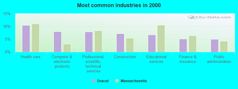
- Health care (10.4%)
- Computer & electronic products (8.0%)
- Professional, scientific, technical services (7.9%)
- Construction (7.2%)
- Educational services (6.8%)
- Finance & insurance (5.1%)
- Public administration (5.0%)
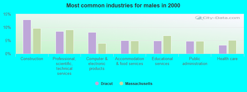
- Construction (12.9%)
- Professional, scientific, technical services (8.5%)
- Computer & electronic products (8.1%)
- Accommodation & food services (5.0%)
- Educational services (4.8%)
- Public administration (4.8%)
- Health care (3.3%)
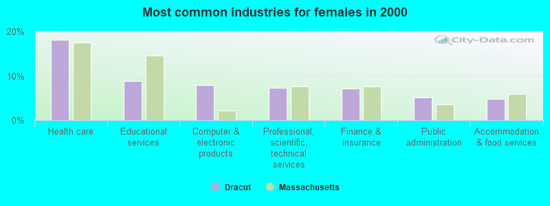
- Health care (18.1%)
- Educational services (8.8%)
- Computer & electronic products (7.9%)
- Professional, scientific, technical services (7.4%)
- Finance & insurance (7.2%)
- Public administration (5.2%)
- Accommodation & food services (4.8%)
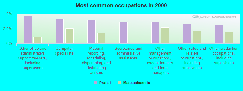
- Other office and administrative support workers, including supervisors (4.7%)
- Computer specialists (4.1%)
- Material recording, scheduling, dispatching, and distributing workers (4.0%)
- Secretaries and administrative assistants (3.7%)
- Other management occupations, except farmers and farm managers (3.6%)
- Other sales and related occupations, including supervisors (3.3%)
- Other production occupations, including supervisors (3.2%)
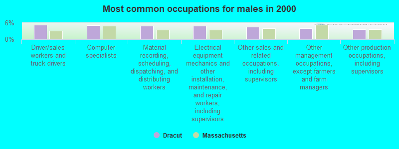
- Driver/sales workers and truck drivers (5.2%)
- Computer specialists (5.1%)
- Material recording, scheduling, dispatching, and distributing workers (4.9%)
- Electrical equipment mechanics and other installation, maintenance, and repair workers, including supervisors (4.9%)
- Other sales and related occupations, including supervisors (4.5%)
- Other management occupations, except farmers and farm managers (4.0%)
- Other production occupations, including supervisors (3.6%)

- Other office and administrative support workers, including supervisors (8.0%)
- Secretaries and administrative assistants (7.7%)
- Registered nurses (4.3%)
- Information and record clerks, except customer service representatives (3.5%)
- Other management occupations, except farmers and farm managers (3.2%)
- Preschool, kindergarten, elementary, and middle school teachers (3.2%)
- Computer specialists (3.2%)
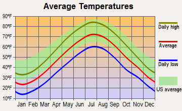
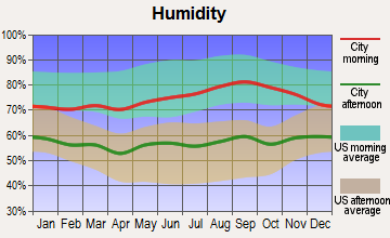
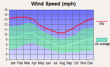
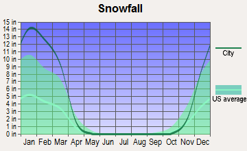
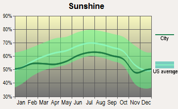
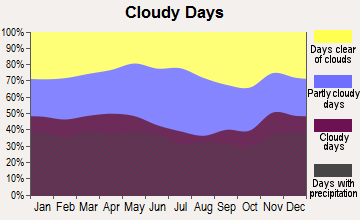
Average climate in Dracut, Massachusetts
Based on data reported by over 4,000 weather stations
(lower is better)
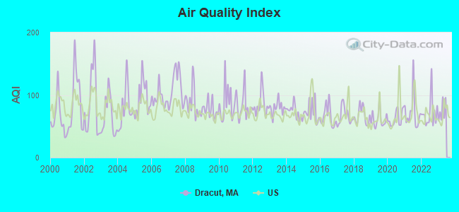
Air Quality Index (AQI) level in 2022 was 71.5. This is about average.
| City: | 71.5 |
| U.S.: | 72.6 |
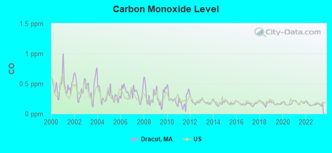
Carbon Monoxide (CO) [ppm] level in 2022 was 0.157. This is significantly better than average. Closest monitor was 2.2 miles away from the city center.
| City: | 0.157 |
| U.S.: | 0.251 |
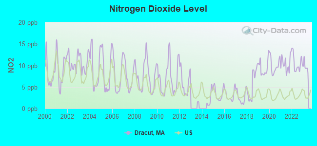
Nitrogen Dioxide (NO2) [ppb] level in 2022 was 10.5. This is significantly worse than average. Closest monitor was 2.2 miles away from the city center.
| City: | 10.5 |
| U.S.: | 5.1 |
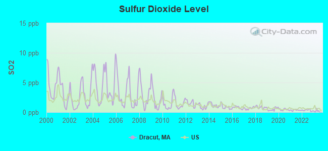
Sulfur Dioxide (SO2) [ppb] level in 2022 was 0.338. This is significantly better than average. Closest monitor was 2.2 miles away from the city center.
| City: | 0.338 |
| U.S.: | 1.515 |
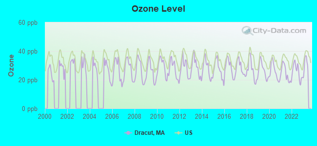
Ozone [ppb] level in 2022 was 25.7. This is better than average. Closest monitor was 2.2 miles away from the city center.
| City: | 25.7 |
| U.S.: | 33.3 |
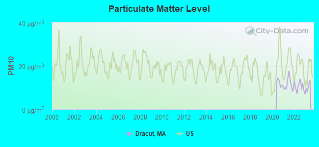
Particulate Matter (PM10) [µg/m3] level in 2022 was 10.6. This is significantly better than average. Closest monitor was 4.2 miles away from the city center.
| City: | 10.6 |
| U.S.: | 19.2 |
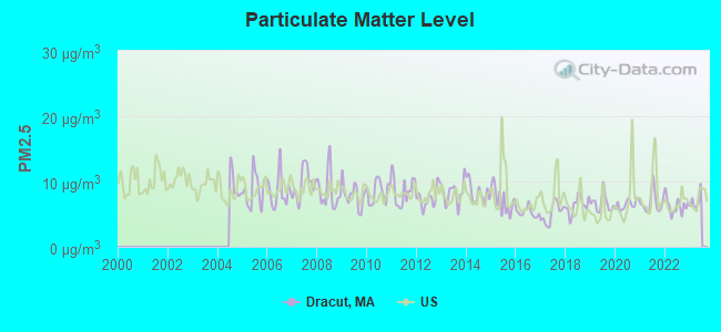
Particulate Matter (PM2.5) [µg/m3] level in 2022 was 6.25. This is better than average. Closest monitor was 2.1 miles away from the city center.
| City: | 6.25 |
| U.S.: | 8.11 |
Tornado activity:
Dracut-area historical tornado activity is near Massachusetts state average. It is 34% smaller than the overall U.S. average.
On 6/9/1953, a category F4 (max. wind speeds 207-260 mph) tornado 28.1 miles away from the Dracut town center killed 90 people and injured 1228 people and caused between $50,000,000 and $500,000,000 in damages.
On 9/29/1974, a category F3 (max. wind speeds 158-206 mph) tornado 6.9 miles away from the town center injured one person and caused between $50,000 and $500,000 in damages.
Earthquake activity:
Dracut-area historical earthquake activity is significantly above Massachusetts state average. It is 72% smaller than the overall U.S. average.On 4/20/2002 at 10:50:47, a magnitude 5.3 (5.3 ML, Depth: 3.0 mi, Class: Moderate, Intensity: VI - VII) earthquake occurred 174.1 miles away from the city center
On 10/7/1983 at 10:18:46, a magnitude 5.3 (5.1 MB, 5.3 LG, 5.1 ML) earthquake occurred 176.0 miles away from Dracut center
On 1/19/1982 at 00:14:42, a magnitude 4.7 (4.5 MB, 4.7 MD, 4.5 LG, Class: Light, Intensity: IV - V) earthquake occurred 58.7 miles away from the city center
On 4/20/2002 at 10:50:47, a magnitude 5.2 (5.2 MB, 4.2 MS, 5.2 MW, 5.0 MW) earthquake occurred 173.6 miles away from Dracut center
On 10/16/2012 at 23:12:25, a magnitude 4.7 (4.7 ML, Depth: 10.0 mi) earthquake occurred 71.8 miles away from Dracut center
On 8/22/1992 at 12:20:32, a magnitude 4.8 (4.8 MB, 3.8 MS, 4.7 LG, Depth: 6.2 mi) earthquake occurred 252.5 miles away from the city center
Magnitude types: regional Lg-wave magnitude (LG), body-wave magnitude (MB), duration magnitude (MD), local magnitude (ML), surface-wave magnitude (MS), moment magnitude (MW)
Natural disasters:
The number of natural disasters in Middlesex County (31) is a lot greater than the US average (15).Major Disasters (Presidential) Declared: 17
Emergencies Declared: 14
Causes of natural disasters: Floods: 12, Storms: 9, Hurricanes: 6, Snowstorms: 6, Winter Storms: 5, Blizzards: 2, Snows: 2, Explosion: 1, Heavy Rain: 1, Snowfall: 1, Water Main Break: 1, Wind: 1 (Note: some incidents may be assigned to more than one category).
Hospitals and medical centers near Dracut:
- HERITAGE SKILLED NURSING AND REHABILITATION (Nursing Home, about 2 miles away; LOWELL, MA)
- CHRISTIAN HILL CONV MOME (Nursing Home, about 2 miles away; LOWELL, MA)
- LOWELL HEALTH CARE CENTER (Nursing Home, about 2 miles away; LOWELL, MA)
- SAINTS MEDICAL CENTER INC Acute Care Hospitals (about 3 miles away; LOWELL, MA)
- LOWELL GENERAL HOSPITAL Acute Care Hospitals (about 3 miles away; LOWELL, MA)
- TRANS CARE UNIT AT LOWELL GENERAL HOSPITAL (Nursing Home, about 3 miles away; LOWELL, MA)
- DR HARRY SOLOMON MHC (Hospital, about 3 miles away; LOWELL, MA)
Colleges/universities with over 2000 students nearest to Dracut:
- University of Massachusetts-Lowell (about 2 miles; Lowell, MA; Full-time enrollment: 12,341)
- Merrimack College (about 10 miles; North Andover, MA; FT enrollment: 2,734)
- Middlesex Community College (about 11 miles; Bedford, MA; FT enrollment: 6,040)
- Northern Essex Community College (about 16 miles; Haverhill, MA; FT enrollment: 4,737)
- North Shore Community College (about 19 miles; Danvers, MA; FT enrollment: 5,195)
- Bentley University (about 21 miles; Waltham, MA; FT enrollment: 5,229)
- Tufts University (about 22 miles; Medford, MA; FT enrollment: 9,041)
Public high schools in Dracut:
- DRACUT SENIOR HIGH (Students: 1,231, Location: 1540 LAKEVIEW AVENUE, Grades: 9-12)
- PARKER AVENUE SCHOOL (Students: 159, Location: 77 PARKER AVENUE, Grades: 9-12)
Public elementary/middle schools in Dracut:
- BROOKSIDE ELEMENTARY (Students: 614, Location: 1560 LAKEVIEW AVENUE, Grades: KG-5)
- JOSEPH A CAMPBELL ELEMENTARY (Students: 557, Location: 1021 METHUEN STREET, Grades: PK-5)
- GREENMONT AVENUE (Students: 251, Location: 37 GREENMONT AVENUE, Grades: KG-5)
- JUSTUS C. RICHARDSON MIDDLE SCHOOL (Location: 1570 LAKEVIEW AVE, Grades: 6-8)
- GEORGE H. ENGLESBY ELEMENTARY SCHOOL (Location: 1580 LAKEVIEW AVE, Grades: KG-5)
Private elementary/middle school in Dracut:
Points of interest:
Notable locations in Dracut: Dracut Fire Department Station 3 (A), Dracut Fire Department Station 2 (B), Dracut Fire Department Station 1 Headquarters (C), Dracut High School Library (D), Moses Greeley Park Memorial Library (E). Display/hide their locations on the map
Churches in Dracut include: Saint Theresas Church (A), Saint Mary of the Assumption Church (B), Grace Bible Church (C), Collinsville Bible Church (D), Christ Church United of Dracut (E). Display/hide their locations on the map
Cemeteries: Oak Grove Cemetery (1), New Boston Cemetery (2), Varnum Cemetery (3), Bailey Cemetery (4), Richardson Cemetery (5), Hamblett Cemetery (6). Display/hide their locations on the map
Lakes, reservoirs, and swamps: Long Pond (A), Cedar Pond (B), Long Pond (C), Peters Pond (D), Beaver Brook Reservoir (E), Richardsons Brook Swamp (F), Spruce Swamp (G). Display/hide their locations on the map
Streams, rivers, and creeks: Gumpas Pond Brook (A), Double Brook (B), Nickel Mine Brook (C), Peppermint Brook (D), Trout Brook (E). Display/hide their locations on the map
Parks in Dracut include: Hovey Square (1), Lowell-Dracut State Forest (2). Display/hide their locations on the map
Tourist attraction: Lowell Amusement CO Inc (Amusement & Theme Parks; 321 Broadway Road) (1). Display/hide its approximate location on the map
Birthplace of: Charles A. Stott - Politician, James Mitchell Varnum - Judge, Joseph Bradley Varnum - Politician, Wendell Corey - Actor, Brian Frederick - College football player (Massachusetts Minutemen), John Varnum - Politician.
Drinking water stations with addresses in Dracut and their reported violations in the past:
DRACUT WATER SUPPLY DISTRICT (Population served: 24,307, Purch surface water):Past health violations:Past monitoring violations:
- MCL, Monthly (TCR) - In AUG-2014, Contaminant: Coliform. Follow-up actions: St AO (w/o penalty) issued (SEP-10-2014)
- Follow-up Or Routine LCR Tap M/R - In OCT-01-2005, Contaminant: Lead and Copper Rule. Follow-up actions: St AO (w/o penalty) issued (JAN-23-2006), St Compliance achieved (OCT-10-2006)
- 67 regular monitoring violations
| This town: | 2.7 people |
| Massachusetts: | 2.5 people |
| This town: | 71.8% |
| Whole state: | 63.0% |
| This town: | 7.3% |
| Whole state: | 7.0% |
Likely homosexual households (counted as self-reported same-sex unmarried-partner households)
- Lesbian couples: 0.5% of all households
- Gay men: 0.4% of all households
| This town: | 3.7% |
| Whole state: | 9.3% |
| This town: | 1.2% |
| Whole state: | 4.4% |
People in group quarters in Dracut in 2010:
- 8 people in group homes intended for adults
- 2 people in residential treatment centers for adults
- 2 people in other noninstitutional facilities
People in group quarters in Dracut in 2000:
- 31 people in homes for the mentally retarded
- 4 people in other group homes
- 4 people in religious group quarters
Banks with branches in Dracut (2011 data):
- Eastern Bank: Dracut Branch at 45 Broadway Road, branch established on 1987/06/05. Info updated 2011/03/30: Bank assets: $7,812.9 mil, Deposits: $6,295.8 mil, headquarters in Boston, MA, positive income, Commercial Lending Specialization, 94 total offices, Holding Company: Eastern Bank Corporation
- Enterprise Bank and Trust Company: Dracut Branch at 1168 Lakeview Avenue, branch established on 1997/11/03. Info updated 2006/11/03: Bank assets: $1,488.4 mil, Deposits: $1,333.6 mil, headquarters in Lowell, MA, positive income, Commercial Lending Specialization, 20 total offices, Holding Company: Enterprise Bancorp, Inc.
- Sovereign Bank, National Association: Dracut Branch at 1985 Lakeview Avenue, branch established on 1962/11/26. Info updated 2012/01/31: Bank assets: $78,146.9 mil, Deposits: $48,042.9 mil, headquarters in Wilmington, DE, positive income, Commercial Lending Specialization, 718 total offices, Holding Company: Banco Santander, S.A.
- TD Bank, National Association: Bridge Street Branch at 1255 Bridge Street, branch established on 1958/12/06. Info updated 2010/10/04: Bank assets: $188,912.6 mil, Deposits: $153,149.8 mil, headquarters in Wilmington, DE, positive income, 1314 total offices, Holding Company: Toronto-Dominion Bank, The
- The Lowell Five Cent Savings Bank: Dracut Branch at 2021 Lakeview Avenue, branch established on 1974/09/06. Info updated 2011/09/19: Bank assets: $738.4 mil, Deposits: $601.2 mil, headquarters in Lowell, MA, positive income, Mortgage Lending Specialization, 13 total offices, Holding Company: Lowell Five Bancorp Mhc
- Washington Savings Bank: Dracut Branch at 100 Broadway Road, branch established on 1997/09/27. Info updated 2012/03/30: Bank assets: $181.8 mil, Deposits: $141.5 mil, headquarters in Lowell, MA, positive income, 3 total offices
For population 15 years and over in Dracut:
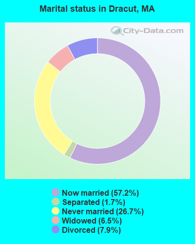
- Never married: 26.7%
- Now married: 57.2%
- Separated: 1.7%
- Widowed: 6.5%
- Divorced: 7.9%
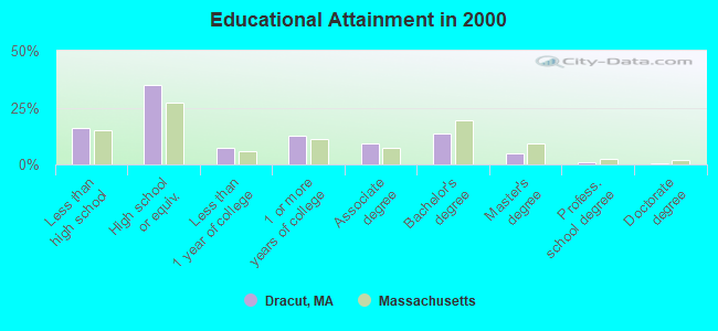
For population 25 years and over in Dracut:
- High school or higher: 83.9%
- Bachelor's degree or higher: 20.1%
- Graduate or professional degree: 6.5%
- Unemployed: 3.1%
- Mean travel time to work (commute): 28.1 minutes
| Here: | 11.5 |
| Massachusetts average: | 13.1 |


Graphs represent county-level data. Detailed 2008 Election Results
Religion statistics for Dracut, MA (based on Middlesex County data)


| Religion | Adherents | Congregations |
|---|---|---|
| Catholic | 718,209 | 107 |
| Mainline Protestant | 70,053 | 269 |
| Other | 68,480 | 199 |
| Evangelical Protestant | 41,270 | 304 |
| Orthodox | 23,641 | 28 |
| Black Protestant | 2,276 | 8 |
| None | 579,156 | - |
Food Environment Statistics:
| Middlesex County: | 1.71 / 10,000 pop. |
| Massachusetts: | 1.98 / 10,000 pop. |
| Middlesex County: | 0.03 / 10,000 pop. |
| State: | 0.05 / 10,000 pop. |
| Middlesex County: | 2.14 / 10,000 pop. |
| State: | 2.22 / 10,000 pop. |
| Middlesex County: | 1.38 / 10,000 pop. |
| Massachusetts: | 1.77 / 10,000 pop. |
| This county: | 7.84 / 10,000 pop. |
| Massachusetts: | 8.76 / 10,000 pop. |
| This county: | 7.8% |
| Massachusetts: | 8.1% |
| Middlesex County: | 21.5% |
| State: | 22.5% |
| This county: | 18.0% |
| State: | 16.5% |
6.91% of this county's 2021 resident taxpayers lived in other counties in 2020 ($102,955 average adjusted gross income)
| Here: | 6.91% |
| Massachusetts average: | 6.35% |
0.01% of residents moved from foreign countries ($137 average AGI)
Middlesex County: 0.01% Massachusetts average: 0.01%
Top counties from which taxpayers relocated into this county between 2020 and 2021:
| from Suffolk County, MA | |
| from Essex County, MA | |
| from Norfolk County, MA |
8.22% of this county's 2020 resident taxpayers moved to other counties in 2021 ($123,369 average adjusted gross income)
| Here: | 8.22% |
| Massachusetts average: | 7.18% |
0.01% of residents moved to foreign countries ($124 average AGI)
Middlesex County: 0.01% Massachusetts average: 0.02%
Top counties to which taxpayers relocated from this county between 2020 and 2021:
| to Suffolk County, MA | |
| to Essex County, MA | |
| to Worcester County, MA |
| Businesses in Dracut, MA | ||||
| Name | Count | Name | Count | |
|---|---|---|---|---|
| CVS | 2 | Ryder Rental & Truck Leasing | 1 | |
| DHL | 1 | Subway | 2 | |
| Dunkin Donuts | 4 | True Value | 2 | |
| FedEx | 1 | U-Haul | 2 | |
| H&R Block | 1 | UPS | 4 | |
| McDonald's | 1 | Wendy's | 1 | |
Strongest AM radio stations in Dracut:
- WCAP (980 AM; 5 kW; LOWELL, MA; Owner: NORTHEAST RADIO, INC.)
- WLLH (1400 AM; 1 kW; LOWELL, MA; Owner: MEGA COMMUNICATIONS OF LOWELL LICENSEE, LLC)
- WRKO (680 AM; 50 kW; BOSTON, MA; Owner: ENTERCOM BOSTON LICENSE, LLC)
- WCEC (1110 AM; daytime; 5 kW; SALEM, NH; Owner: COSTA-EAGLE RADIO VENTURES LTD PARTNERSHIP)
- WWZN (1510 AM; 50 kW; BOSTON, MA; Owner: ROSE CITY RADIO CORPORATION)
- WEEI (850 AM; 50 kW; BOSTON, MA; Owner: ENTERCOM BOSTON LICENSE, LLC)
- WKOX (1200 AM; 50 kW; FRAMINGHAM, MA; Owner: CAPSTAR TX LIMITED PARTNERSHIP)
- WBIX (1060 AM; 40 kW; NATICK, MA; Owner: LANGER BROADCASTING CORPORATION)
- WDER (1320 AM; 10 kW; DERRY, NH; Owner: BLOUNT COMMUNICATIONS, INC. OF NH)
- WBZ (1030 AM; 50 kW; BOSTON, MA; Owner: INFINITY BROADCASTING OPERATIONS, INC.)
- WRCA (1330 AM; 25 kW; WALTHAM, MA; Owner: WRCA LICENSE, LLC)
- WCRN (830 AM; 50 kW; WORCESTER, MA; Owner: CARTER BROADCASTING CORPORATION)
- WSMN (1590 AM; 5 kW; NASHUA, NH; Owner: 1590 BROADCASTING CORP.)
Strongest FM radio stations in Dracut:
- WJUL (91.5 FM; LOWELL, MA; Owner: UNIVERSITY OF MASSACHUSETTS, LOWELL)
- WKLB-FM (99.5 FM; LOWELL, MA; Owner: GREATER BOSTON RADIO, INC.)
- W227AM (93.3 FM; ANDOVER, MA; Owner: GREATER BOSTON RADIO, INC.)
- WHOB (106.3 FM; NASHUA, NH; Owner: TELE-MEDIA COMPANY OF NEW HAMPSHIRE, L.L.C.)
- WXRV (92.5 FM; HAVERHILL, MA; Owner: BEANPOT BROADCASTING CORP.)
- WXKS-FM (107.9 FM; MEDFORD, MA; Owner: AMFM RADIO LICENSES, L.L.C.)
- WBMX (98.5 FM; BOSTON, MA; Owner: INFINITY RADIO OPERATIONS INC.)
- WMJX (106.7 FM; BOSTON, MA; Owner: GREATER BOSTON RADIO, INC.)
- WJMN (94.5 FM; BOSTON, MA; Owner: AMFM RADIO LICENSES, L.L.C.)
- WCRB (102.5 FM; WALTHAM, MA; Owner: CHARLES RIVER BROADCASTING WCRB LICE)
- WTKK (96.9 FM; BOSTON, MA; Owner: GREATER BOSTON RADIO, INC.)
- WROR-FM (105.7 FM; FRAMINGHAM, MA; Owner: GREATER BOSTON RADIO, INC.)
- WBOS (92.9 FM; BROOKLINE, MA; Owner: GREATER BOSTON RADIO, INC.)
- WFEX (92.1 FM; PETERBOROUGH, NH; Owner: FNX BROADCASTING OF NEW HAMPSHIRE LLC)
- WGBH (89.7 FM; BOSTON, MA; Owner: WGBH EDUCATIONAL FOUNDATION)
- WGIR-FM (101.1 FM; MANCHESTER, NH; Owner: CAPSTAR TX LIMITED PARTNERSHIP)
- WQLL (96.5 FM; BEDFORD, NH; Owner: SAGA COMMUNICATIONS OF NEW ENGLAND, LLC)
- WBUR-FM (90.9 FM; BOSTON, MA; Owner: TRUSTEES OF BOSTON UNIVERSITY)
- WLMW (90.7 FM; MANCHESTER, NH; Owner: KNOWLEDGE FOR LIFE)
- WZID (95.7 FM; MANCHESTER, NH; Owner: SAGA COMMUNICATIONS OF NEW ENGLAND, LLC)
TV broadcast stations around Dracut:
- WFXZ-CA (Channel 24; BOSTON, MA; Owner: BOSTON BROADCASTING CORP.)
- WNDS (Channel 50; DERRY, NH; Owner: CTV OF DERRY, INC)
- WCVB-TV (Channel 5; BOSTON, MA; Owner: WCVB HEARST-ARGYLE TV, INC.)
- WGBH-TV (Channel 2; BOSTON, MA; Owner: WGBH EDUCATIONAL FOUNDATION)
- WUTF (Channel 66; MARLBOROUGH, MA; Owner: TELEFUTURA BOSTON LLC)
- WHDH-TV (Channel 7; BOSTON, MA; Owner: WHDH-TV)
- WMFP (Channel 62; LAWRENCE, MA; Owner: WSAH LICENSE, INC.)
- WBZ-TV (Channel 4; BOSTON, MA; Owner: VIACOM INC.)
- WGBX-TV (Channel 44; BOSTON, MA; Owner: WGBH EDUCATIONAL FOUNDATION)
- WSBK-TV (Channel 38; BOSTON, MA; Owner: VIACOM INC.)
- WLVI-TV (Channel 56; CAMBRIDGE, MA; Owner: WLVI, INC.)
- WFXT (Channel 25; BOSTON, MA; Owner: FOX TELEVISION STATIONS INC.)
- WUNI (Channel 27; WORCESTER, MA; Owner: ENTRAVISION HOLDINGS, LLC)
- WBPX (Channel 68; BOSTON, MA; Owner: PAXSON BOSTON-68 LICENSE, INC.)
- W40BO (Channel 40; BOSTON, MA; Owner: PAXSON COMMUNICATIONS LPTV, INC.)
- WTMU-LP (Channel 32; BOSTON, MA; Owner: ZGS BOSTON, INC.)
- WCEA-LP (Channel 58; BOSTON, MA; Owner: CHANNEL 19 TV CORPORATION)
- WHDN-LP (Channel 26; BOSTON, MA; Owner: GUENTER MARKSTEINER)
- WYCN-LP (Channel 13; NASHUA, NH; Owner: CENTER BROADCASTING CORP. OF NEW HAMPSHIRE)
- W33AK (Channel 33; NASHUA, NH; Owner: CENTER B/CING CORPORATION OF NEW HAMPSHIRE)
- National Bridge Inventory (NBI) Statistics
- 5Number of bridges
- 33ft / 10.2mTotal length
- $7,718,000Total costs
- 55,596Total average daily traffic
- 1,967Total average daily truck traffic
- 97,917Total future (year 2031) average daily traffic
FCC Registered Antenna Towers:
44 (See the full list of FCC Registered Antenna Towers in Dracut)FCC Registered Broadcast Land Mobile Towers:
12 (See the full list of FCC Registered Broadcast Land Mobile Towers in Dracut, MA)FCC Registered Microwave Towers:
13 (See the full list of FCC Registered Microwave Towers in this town)FCC Registered Amateur Radio Licenses:
106 (See the full list of FCC Registered Amateur Radio Licenses in Dracut)FAA Registered Aircraft:
4- Aircraft: PIPER PA-28R-201 (Category: Land, Seats: 4, Weight: Up to 12,499 Pounds, Speed: 108 mph), Engine: LYCOMING I0360 SER (180 HP) (Reciprocating)
N-Number: 1043Q, N1043Q, N-1043Q, Serial Number: 28R-7737025, Year manufactured: 1977, Airworthiness Date: 02/21/1977, Certificate Issue Date: 04/19/2004
Registrant (Individual): James A Philippou, 19 Brentwood Dr, Dracut, MA 01826 - Aircraft: CESSNA 182E (Category: Land, Seats: 4, Weight: Up to 12,499 Pounds, Speed: 119 mph), Engine: CONT MOTOR O-470 SERIES (230 HP) (Reciprocating)
N-Number: 3514Y, N3514Y, N-3514Y, Serial Number: 18254414, Year manufactured: 1962, Airworthiness Date: 09/26/1962, Certificate Issue Date: 04/23/1996
Registrant (Individual): Edward W Cielakie, 36 Lafayette St, Dracut, MA 01826 - Aircraft: PIPER PA-28R-200 (Category: Land, Seats: 4, Weight: Up to 12,499 Pounds, Speed: 107 mph), Engine: LYCOMING I0360 SER (180 HP) (Reciprocating)
N-Number: 428F, N428F, N-428F, Serial Number: 28R-35201, Year manufactured: 1969, Airworthiness Date: 04/24/1969, Certificate Issue Date: 05/24/1990
Registrant (Individual): David M Courtenay, 954 Mammoth Rd, Dracut, MA 01826 - Aircraft: LLOYD BRIAN G V-MAX (Category: Land, Weight: Up to 12,499 Pounds), Engine: AMA/EXPR UNKNOWN ENG (Reciprocating)
N-Number: 417BJ, N417BJ, N-417BJ, Serial Number: 001, Year manufactured: 2017, Airworthiness Date: 09/21/2017, Certificate Issue Date: 02/27/2017
Registrant (Individual): Brian G Lloyd, 184 Long Pond Dr, Dracut, MA 01826
Deregistered: Cancel Date: 05/29/2020
2002 - 2018 National Fire Incident Reporting System (NFIRS) incidents
- Fire incident types reported to NFIRS in Dracut, MA
- 55437.7%Outside Fires
- 54937.4%Structure Fires
- 19313.1%Mobile Property/Vehicle Fires
- 17311.8%Other
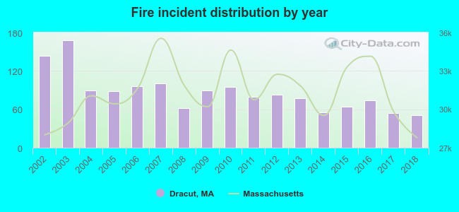 Based on the data from the years 2002 - 2018 the average number of fire incidents per year is 86. The highest number of reported fire incidents - 168 took place in 2003, and the least - 51 in 2018. The data has a declining trend.
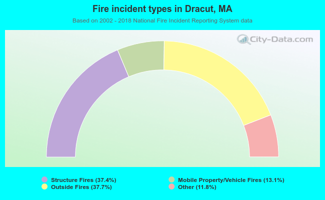 When looking into fire subcategories, the most incidents belonged to: Outside Fires (37.7%), and Structure Fires (37.4%).
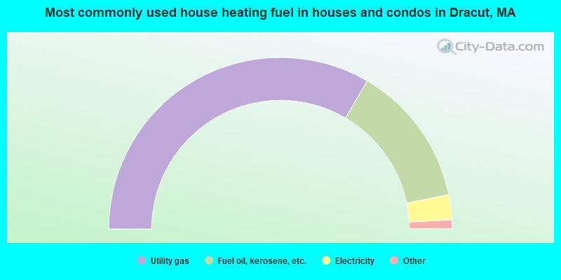
- 66.8%Utility gas
- 26.7%Fuel oil, kerosene, etc.
- 4.7%Electricity
- 0.7%Wood
- 0.6%Bottled, tank, or LP gas
- 0.2%Coal or coke
- 0.2%No fuel used
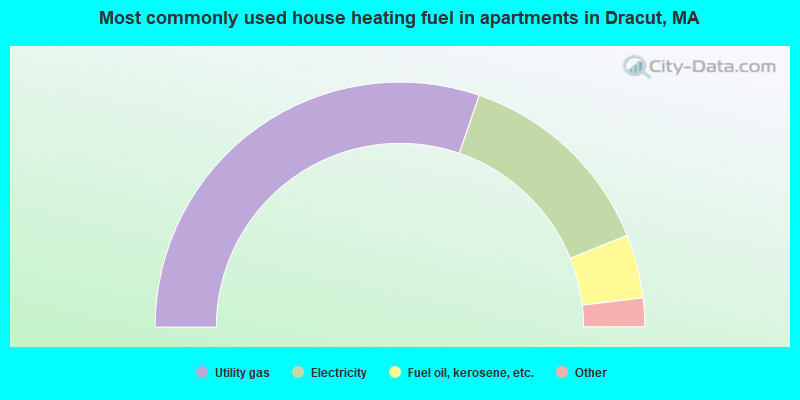
- 60.5%Utility gas
- 27.3%Electricity
- 8.4%Fuel oil, kerosene, etc.
- 2.6%Bottled, tank, or LP gas
- 0.7%Other fuel
- 0.5%No fuel used
Dracut compared to Massachusetts state average:
- Unemployed percentage significantly below state average.
- Black race population percentage below state average.
- Hispanic race population percentage significantly below state average.
- Foreign-born population percentage significantly below state average.
- Renting percentage below state average.
- Length of stay since moving in significantly above state average.
- Number of rooms per house significantly below state average.
- House age significantly below state average.
- Percentage of population with a bachelor's degree or higher below state average.
Dracut on our top lists:
- #15 on the list of "Top 101 cities with largest percentage of females in industries: computer and electronic products (population 5,000+)"
- #37 on the list of "Top 101 cities with largest percentage of females in industries: electrical and electronic goods merchant wholesalers (population 5,000+)"
- #51 on the list of "Top 101 cities with largest percentage of males in occupations: occupational and physical therapist assistants and aides (population 5,000+)"
- #57 on the list of "Top 101 cities with largest percentage of males in industries: computer and electronic products (population 5,000+)"
- #71 on the list of "Top 101 cities with largest percentage of females in occupations: other financial specialists (population 5,000+)"
- #78 on the list of "Top 101 cities with largest percentage of females in industries: lumber and other construction materials merchant wholesalers (population 5,000+)"
- #79 on the list of "Top 101 cities with largest percentage of males in occupations: drafters, engineering, and mapping technicians (population 5,000+)"
- #82 on the list of "Top 101 cities with largest percentage of females in occupations: air transportation workers (population 5,000+)"
- #91 on the list of "Top 101 cities with largest percentage of females in occupations: other construction workers and helpers (population 5,000+)"
- #93 on the list of "Top 101 cities with largest percentage of females in occupations: engineers (population 5,000+)"
- #60 (01826) on the list of "Top 101 zip codes with the largest percentage of Greek first ancestries (pop 5,000+)"
- #64 (01826) on the list of "Top 101 zip codes with the largest percentage of French Canadian first ancestries (pop 5,000+)"
- #4 on the list of "Top 101 counties with the most Orthodox adherents"
- #7 on the list of "Top 101 counties with the most Catholic adherents"
- #7 on the list of "Top 101 counties with the most Mainline Protestant congregations"
- #7 on the list of "Top 101 counties with the most Orthodox congregations"
- #8 on the list of "Top 101 counties with the lowest percentage of residents that keep firearms around their homes"

|
|
Total of 342 patent applications in 2008-2024.